Bridge Statistics for Pine Level, North Carolina (NC)
Condition, Traffic, Stress, Structural Evaluation, Project Costs
- National Bridge Inventory (NBI) Statistics
- 12Number of bridges
- 49ft / 15.3mTotal length
- 93,360Total average daily traffic
- 11,302Total average daily truck traffic
- National Bridge Inventory (NBI) Registered Bridges for Pine Level
- No street view available for this location
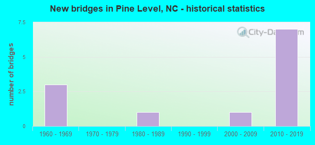
- New bridges - historical statistics
- 31960-1969
- 11980-1989
- 12000-2009
- 72010-2019


- Bridge Condition - Deck
- 40.0%Very good
- 40.0%Good
- 20.0%Satisfactory

- Bridge Condition - Superstructure
- 20.0%Excellent
- 20.0%Very good
- 40.0%Good
- 20.0%Satisfactory

- Bridge Condition - Substructure
- 20.0%Excellent
- 20.0%Very good
- 40.0%Satisfactory
- 20.0%Fair

- Bridge Condition - Channel
- 83.3%Good
- 16.7%Satisfactory
Find on map >> Show street view
Structure Number: 1010003, Location: 0.8 MI.N.JCT.SR1007 (Lat: 35.442414, Lng: -78.241614), Route carried "on" structure: State highway 2310, Year Built: 1981, Status: Open, Structure Length: 2.80m (9.19ft), Average Daily Traffic: 1,200 (year 2012), Truck Traffic: 6%, Average Future Daily Traffic: 2,400 (year 2040), Design Load: HS 20+Mod, Features Intersected: BAWDY CREEK
Minimum Vertical Clearance: 30+ m (98+ ft), Kilometerpoint: 0.000, Lanes on structure: 2, Owner: State Highway Agency, Approaching Roadway Width: 8.2m (26.9ft), Material/Design: Prestressed concrete, Design/Construction: Slab, Number Of Spans In Main Unit: 3, Length of Maximum Span: 8.8m (28.9ft), Curb-To-Curb Width: 9.3m (30.5ft), Out-to-Out Width: 10.0m (32.8ft)
Condition: Deck: Good, Superstructure: Good, Substructure: Satisfactory, Channel: Good, Operating Rating: 89.8 metric tons, Method Used To Determine Operating Rating: Load Factor (LF), Inventory Rating: 58.9 metric tons, Method Used To Determine Inventory Rating: Load Factor (LF), Structural Evaluation: Equal to present minimum criteria, Deck Geometry: Somewhat better than minimum adequacy, Waterway Adequacy: Better than present minimum criteria, Approach Roadway Alignment: Equal to present desirable criteria, Designated Inspection Frequency: Every 24 months, Inspection Date: Febuary 2022, Deck Structure Type: Concrete Cast-file-Place, Wearing Surface/Protective System: Wearing Surface: Bituminous
Find on map >> Show street view
Structure Number: 1010256, Location: 0.2MI.N.JCT SR2312 (Lat: 35.508267, Lng: -78.232958), Route carried "on" structure: State highway 2324, Year Built: 2001, Status: Open, Structure Length: 1.82m (5.97ft), Average Daily Traffic: 100 (year 1996), Truck Traffic: 6%, Average Future Daily Traffic: 200 (year 2040), Design Load: HS 20+Mod, Features Intersected: MOCASSIN CREEK
Minimum Vertical Clearance: 30+ m (98+ ft), Kilometerpoint: 0.000, Lanes on structure: 2, Owner: State Highway Agency, Approaching Roadway Width: 6.4m (21.0ft), Skew: 1 degrees, Material/Design: Prestressed concrete, Design/Construction: Slab, Number Of Spans In Main Unit: 1, Length of Maximum Span: 17.3m (56.8ft), Curb-To-Curb Width: 7.3m (24.0ft), Out-to-Out Width: 8.2m (26.9ft)
Condition: Deck: Good, Superstructure: Good, Substructure: Satisfactory, Channel: Good, Operating Rating: 66.2 metric tons, Method Used To Determine Operating Rating: Load Factor (LF), Inventory Rating: 39.9 metric tons, Method Used To Determine Inventory Rating: Load Factor (LF), Structural Evaluation: Equal to present minimum criteria, Deck Geometry: Equal to present minimum criteria, Waterway Adequacy: Better than present minimum criteria, Approach Roadway Alignment: Equal to present desirable criteria, Designated Inspection Frequency: Every 24 months, Inspection Date: October 2021, Deck Structure Type: Concrete Precast Panels, Wearing Surface/Protective System: Wearing Surface: Bituminous
Find on map >> Show street view
Structure Number: 1010327, Location: 0.3MI.W. OF JCT.US70A (Lat: 35.488461, Lng: -78.212592), Route carried "on" structure: State highway 2141, Year Built: 2014, Status: Open, Structure Length: 1.73m (5.68ft), Average Daily Traffic: 700 (year 2019), Truck Traffic: 6%, Average Future Daily Traffic: 1,400 (year 2040), Design Load: HL 93, Features Intersected: MOCCASIN CREEK
Minimum Vertical Clearance: 30+ m (98+ ft), Kilometerpoint: 0.000, Lanes on structure: 2, Owner: State Highway Agency, Approaching Roadway Width: 7.3m (24.0ft), Material/Design: Prestressed concrete, Design/Construction: Slab, Number Of Spans In Main Unit: 1, Length of Maximum Span: 16.4m (53.8ft), Curb-To-Curb Width: 8.2m (26.9ft), Out-to-Out Width: 9.1m (29.9ft)
Condition: Deck: Very good, Superstructure: Very good, Substructure: Very good, Channel: Good, Operating Rating: 70.7 metric tons, Method Used To Determine Operating Rating: Load and Resistance Factor (LRFR), Inventory Rating: 45.3 metric tons, Method Used To Determine Inventory Rating: Load and Resistance Factor (LRFR), Structural Evaluation: Equal to present desirable criteria, Deck Geometry: Somewhat better than minimum adequacy, Waterway Adequacy: Better than present minimum criteria, Approach Roadway Alignment: Equal to present desirable criteria, Designated Inspection Frequency: Every 24 months, Inspection Date: Febuary 2021, Deck Structure Type: Concrete Cast-file-Place, Wearing Surface/Protective System: Wearing Surface: Bituminous, Deck Protection: Epoxy Coated Reinforcing
Find on map >> Show street view
Structure Number: 1010423, Location: 0.05MI.N. JCT. OF US70 (Lat: 35.501078, Lng: -78.279381), Route carried "on" structure: State highway 2305, Year Built: 1963, Status: Posted for load, Structure Length: 1.09m (3.58ft), Average Daily Traffic: 460 (year 2017), Truck Traffic: 6%, Average Future Daily Traffic: 920 (year 2040), Features Intersected: BAWDY CREEK
Minimum Vertical Clearance: 30+ m (98+ ft), Kilometerpoint: 0.000, Lanes on structure: 2, Owner: State Highway Agency, Approaching Roadway Width: 6.0m (19.7ft), Material/Design: Wood or Timber, Design/Construction: Stringer/Multi-beam, Number Of Spans In Main Unit: 2, Length of Maximum Span: 5.1m (16.7ft), Curb-To-Curb Width: 7.3m (24.0ft), Out-to-Out Width: 8.3m (27.2ft)
Condition: Deck: Satisfactory, Superstructure: Satisfactory, Substructure: Fair, Channel: Good, Operating Rating: 26.3 metric tons, Method Used To Determine Operating Rating: Allowable Stress (AS), Inventory Rating: 16.3 metric tons, Method Used To Determine Inventory Rating: Allowable Stress (AS), Structural Evaluation: Somewhat better than minimum adequacy, Deck Geometry: Meets minimum limits, Waterway Adequacy: Better than present minimum criteria, Approach Roadway Alignment: Equal to present desirable criteria, Bridge Posting: Required (Relationship of Operating Rating to Maximum Legal Load: > 39.9% below), Designated Inspection Frequency: Every 24 months, Inspection Date: October 2020, Deck Structure Type: Concrete Cast-file-Place, Wearing Surface/Protective System: Wearing Surface: Bituminous
Find on map >> Show street view
Structure Number: 1010458, Location: 0.2MI.S.JCT.SR2516 (Lat: 35.469272, Lng: -78.263267), Route carried "on" structure: State highway 2597, Year Built: 1964, Status: Open, Structure Length: 0.76m (2.49ft), Average Daily Traffic: 600 (year 2018), Truck Traffic: 6%, Average Future Daily Traffic: 1,200 (year 2040), Design Load: HS 20+Mod, Features Intersected: BAWDY CREEK
Minimum Vertical Clearance: 30+ m (98+ ft), Kilometerpoint: 0.000, Lanes on structure: 2, Owner: State Highway Agency, Approaching Roadway Width: 6.0m (19.7ft), Material/Design: Steel, Design/Construction: Culvert, Number Of Spans In Main Unit: 2, Length of Maximum Span: 3.3m (10.8ft)
Condition: Channel: Good, Culverts: Fair, Operating Rating: 89.8 metric tons, Method Used To Determine Operating Rating: Load and Resistance Factor (LRFR), Inventory Rating: 89.8 metric tons, Method Used To Determine Inventory Rating: Load and Resistance Factor (LRFR), Structural Evaluation: Somewhat better than minimum adequacy, Waterway Adequacy: Better than present minimum criteria, Approach Roadway Alignment: Equal to present desirable criteria, Designated Inspection Frequency: Every 24 months, Inspection Date: March 2021
Find on map >> Show street view
Structure Number: 1010515, Location: O.5 MI.E.JCT.SR2312 (Lat: 35.502828, Lng: -78.228867), Route carried "on" structure: Alternate US 70, Year Built: 1960, Status: Open, Structure Length: 1.09m (3.58ft), Average Daily Traffic: 4,100 (year 2019), Truck Traffic: 7%, Average Future Daily Traffic: 8,200 (year 2040), Design Load: HS 20+Mod, Features Intersected: MOCASSIN CREEK
Minimum Vertical Clearance: 30+ m (98+ ft), Kilometerpoint: 0.000, Lanes on structure: 2, Owner: State Highway Agency, Approaching Roadway Width: 9.4m (30.8ft), Skew: 3 degrees, Material/Design: Concrete continuous, Design/Construction: Culvert, Number Of Spans In Main Unit: 3, Length of Maximum Span: 3.0m (9.8ft)
Condition: Channel: Satisfactory, Culverts: Fair, Operating Rating: 41.7 metric tons, Method Used To Determine Operating Rating: Field evaluation and documented engineering judgment, Inventory Rating: 32.6 metric tons, Method Used To Determine Inventory Rating: Field evaluation and documented engineering judgment, Structural Evaluation: Somewhat better than minimum adequacy, Waterway Adequacy: Better than present minimum criteria, Approach Roadway Alignment: Equal to present desirable criteria, Designated Inspection Frequency: Every 24 months, Inspection Date: October 2021
Find on map >> Show street view
Structure Number: 1010621, Location: 1.29 MI. S. JCT. SR2311 (Lat: 35.482861, Lng: -78.245250), Route carried "on" structure: State highway 2310, Year Built: 2017, Status: Open, Structure Length: 5.97m (19.59ft), Average Daily Traffic: 1,200 (year 2014), Truck Traffic: 6%, Average Future Daily Traffic: 2,400 (year 2040), Design Load: HL 93, Features Intersected: US70BYP.
Minimum Vertical Clearance: 30+ m (98+ ft), Kilometerpoint: 0.000, Lanes on structure: 2, Lanes under structure: 6, Owner: State Highway Agency, Approaching Roadway Width: 6.0m (19.7ft), Skew: 1 degrees, Material/Design: Steel, Design/Construction: Stringer/Multi-beam, Number Of Spans In Main Unit: 2, Length of Maximum Span: 28.9m (94.8ft), Curb-To-Curb Width: 12.0m (39.4ft), Out-to-Out Width: 13.1m (43.0ft)
Condition: Deck: Very good, Superstructure: Excellent, Substructure: Excellent, Operating Rating: 75.2 metric tons, Method Used To Determine Operating Rating: Load and Resistance Factor (LRFR), Inventory Rating: 55.3 metric tons, Method Used To Determine Inventory Rating: Load and Resistance Factor (LRFR), Structural Evaluation: Superior to present desirable criteria, Deck Geometry: Equal to present minimum criteria, Underclear: Meets minimum limits, Approach Roadway Alignment: Equal to present desirable criteria, Designated Inspection Frequency: Every 24 months, Inspection Date: November 2021, Deck Structure Type: Concrete Cast-file-Place, Wearing Surface/Protective System: Wearing Surface: Monolithic Concrete, Deck Protection: Epoxy Coated Reinforcing
Find on map >> Show street view
Structure Number: 101062, Location: 0.01 MI. W. JCT. SR2307 (Lat: 35.491500, Lng: -78.270361), Route carried "under" structure: Bypass US 70, Year Built: 2017, Structure Length: 0. m, Average Daily Traffic: 19,000 (year 2018), Truck Traffic: 12%, Features Intersected: US70BUS,NC210, Facility Carried by Structure: ,BYPASS
Minimum Vertical Clearance: 5.25m (17.22ft), Kilometerpoint: 0.000, Lanes on structure: 4, Lanes under structure: 3, Material/Design: Steel, Design/Construction: Stringer/Multi-beam, Length of Maximum Span: 44.5m (146.0ft)
Find on map >> Show street view
Structure Number: 101062, Location: 0.01 MI. W. JCT. SR2307 (Lat: 35.491500, Lng: -78.270361), Route carried "under" structure: Bypass US 70, Year Built: 2017, Structure Length: 0. m, Average Daily Traffic: 19,000 (year 2018), Truck Traffic: 12%, Features Intersected: US70BUS,NC210
Minimum Vertical Clearance: 5.53m (18.14ft), Kilometerpoint: 0.000, Lanes on structure: 4, Lanes under structure: 3, Material/Design: Steel, Design/Construction: Stringer/Multi-beam, Length of Maximum Span: 44.5m (146.0ft)
Find on map >> Show street view
Structure Number: 1010621, Location: 1.29 MI. S. JCT. SR2311 (Lat: 35.482861, Lng: -78.245250), Route carried "under" structure: Bypass US 70, Year Built: 2017, Structure Length: 0. m, Average Daily Traffic: 14,000 (year 2019), Truck Traffic: 14%, Features Intersected: SR2310
Minimum Vertical Clearance: 5.28m (17.32ft), Kilometerpoint: 0.000, Lanes on structure: 2, Lanes under structure: 3, Material/Design: Steel, Design/Construction: Stringer/Multi-beam, Length of Maximum Span: 28.9m (94.8ft)
Find on map >> Show street view
Structure Number: 1010621, Location: 1.29 MI. S. JCT. SR2311 (Lat: 35.482861, Lng: -78.245250), Route carried "under" structure: Bypass US 70, Year Built: 2017, Structure Length: 0. m, Average Daily Traffic: 14,000 (year 2019), Truck Traffic: 14%, Features Intersected: SR2310
Minimum Vertical Clearance: 5.41m (17.75ft), Kilometerpoint: 0.000, Lanes on structure: 2, Lanes under structure: 3, Material/Design: Steel, Design/Construction: Stringer/Multi-beam, Length of Maximum Span: 28.9m (94.8ft)