Bridge Statistics for Pinehurst, Idaho (ID)
Condition, Traffic, Stress, Structural Evaluation, Project Costs
- National Bridge Inventory (NBI) Statistics
- 36Number of bridges
- 456ft / 139mTotal length
- $29,128,000Total costs
- 102,485Total average daily traffic
- 18,056Total average daily truck traffic
- National Bridge Inventory (NBI) Registered Bridges for Pinehurst
- No street view available for this location
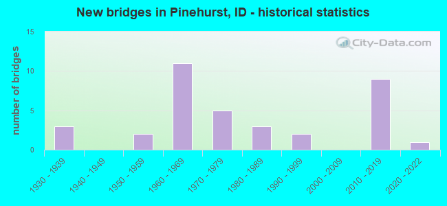
- New bridges - historical statistics
- 31930-1939
- 21950-1959
- 111960-1969
- 51970-1979
- 31980-1989
- 21990-1999
- 92010-2019
- 12020-2022


- Bridge Condition - Deck
- 3.7%Excellent
- 14.8%Very good
- 25.9%Good
- 40.7%Satisfactory
- 14.8%Fair

- Bridge Condition - Superstructure
- 3.7%Excellent
- 25.9%Very good
- 29.6%Good
- 33.3%Satisfactory
- 7.4%Fair

- Bridge Condition - Substructure
- 3.7%Excellent
- 29.6%Very good
- 3.7%Good
- 37.0%Satisfactory
- 22.2%Fair
- 3.7%Poor

- Bridge Condition - Channel
- 4.3%Excellent
- 26.1%Very good
- 4.3%Good
- 47.8%Satisfactory
- 8.7%Fair
- 8.7%Poor
Find on map >> Show street view
Structure Number: 1707, Location: 5.0 W. KELLOGG (Lat: 47.546222, Lng: -116.227111), Route carried "on" structure: Interstate 90, Year Built: 1965, Status: Open, Structure Length: 12.07m (39.60ft), Average Daily Traffic: 7,250 (year 2019), Truck Traffic: 20%, Average Future Daily Traffic: 10,875 (year 2039), Design Load: HS 20, Features Intersected: S 5750;PINE CR;PINEHURST
Minimum Vertical Clearance: 30+ m (98+ ft), Kilometerpoint: 72.781, Lanes on structure: 2, Lanes under structure: 2, Base Highway Network: Yes (Inventory Route: I, Subroute: 1), Owner: State Highway Agency, Approaching Roadway Width: 12.2m (40.0ft), Skew: 4 degrees, Material/Design: Prestressed concrete, Design/Construction: Stringer/Multi-beam, Number Of Spans In Main Unit: 5, Length of Maximum Span: 25.9m (85.0ft), Curb-To-Curb Width: 9.1m (29.9ft), Out-to-Out Width: 10.2m (33.5ft)
Condition: Deck: Satisfactory, Superstructure: Satisfactory, Substructure: Satisfactory, Channel: Satisfactory, Operating Rating: 81.6 metric tons, Method Used To Determine Operating Rating: Load Factor (LF), Inventory Rating: 48.1 metric tons, Method Used To Determine Inventory Rating: Load Factor (LF), Structural Evaluation: Equal to present minimum criteria, Deck Geometry: Meets minimum limits, Underclear: Meets minimum limits, Waterway Adequacy: Superior to present desirable criteria, Approach Roadway Alignment: Equal to present desirable criteria, Length Of Structure Improvement: 13.29m (43.60ft), Designated Inspection Frequency: Every 24 months, Underwater Inspection Frequency: Every 60 months, Inspection Date: June 2021, Underwater Inspection Date: September 2021, Bridge Improvement Cost: $2,734,000, Roadway Improvement Cost: $270,000, Total Project Cost: $4,101,000 ( Estimate for 2019), Deck Structure Type: Concrete Cast-file-Place, Wearing Surface/Protective System: Wearing Surface: Latex Concrete
Find on map >> Show street view
Structure Number: 17075, Location: 5.0 W. KELLOGG (Lat: 47.547064, Lng: -116.225744), Route carried "on" structure: Interstate 90, Year Built: 1965, Status: Open, Structure Length: 12.37m (40.58ft), Average Daily Traffic: 7,250 (year 2019), Truck Traffic: 20%, Average Future Daily Traffic: 10,875 (year 2039), Design Load: HS 20, Features Intersected: S 5750;PINE CR;PINEHURST
Minimum Vertical Clearance: 30+ m (98+ ft), Kilometerpoint: 72.782, Lanes on structure: 2, Lanes under structure: 2, Base Highway Network: Yes (Inventory Route: I, Subroute: 1), Owner: State Highway Agency, Approaching Roadway Width: 11.9m (39.0ft), Skew: 4 degrees, Material/Design: Prestressed concrete, Design/Construction: Stringer/Multi-beam, Number Of Spans In Main Unit: 5, Length of Maximum Span: 26.8m (87.9ft), Curb-To-Curb Width: 9.1m (29.9ft), Out-to-Out Width: 10.2m (33.5ft)
Condition: Deck: Satisfactory, Superstructure: Satisfactory, Substructure: Satisfactory, Channel: Satisfactory, Operating Rating: 78.0 metric tons, Method Used To Determine Operating Rating: Load Factor (LF), Inventory Rating: 45.4 metric tons, Method Used To Determine Inventory Rating: Load Factor (LF), Structural Evaluation: Equal to present minimum criteria, Deck Geometry: Meets minimum limits, Underclear: Meets minimum limits, Waterway Adequacy: Superior to present desirable criteria, Approach Roadway Alignment: Equal to present desirable criteria, Length Of Structure Improvement: 13.62m (44.69ft), Designated Inspection Frequency: Every 24 months, Underwater Inspection Frequency: Every 60 months, Inspection Date: June 2021, Underwater Inspection Date: September 2021, Bridge Improvement Cost: $2,803,000, Roadway Improvement Cost: $280,000, Total Project Cost: $4,204,000 ( Estimate for 2019), Deck Structure Type: Concrete Cast-file-Place, Wearing Surface/Protective System: Wearing Surface: Latex Concrete
Find on map >> Show street view
Structure Number: 17081, Location: 4.7 W. KELLOGG (Lat: 47.548022, Lng: -116.221139), Route carried "on" structure: Interstate 90, Year Built: 2015, Status: Open, Structure Length: 8.87m (29.10ft), Average Daily Traffic: 8,750 (year 2019), Truck Traffic: 17%, Average Future Daily Traffic: 13,125 (year 2039), Design Load: HL 93, Features Intersected: PINEHURST ROAD GS
Minimum Vertical Clearance: 30+ m (98+ ft), Kilometerpoint: 73.193, Lanes on structure: 3, Lanes under structure: 2, Base Highway Network: Yes (Inventory Route: I, Subroute: 1), Owner: State Highway Agency, Approaching Roadway Width: 12.4m (40.7ft), Skew: 5 degrees, Material/Design: Prestressed concrete, Design/Construction: Stringer/Multi-beam, Number Of Spans In Main Unit: 4, Length of Maximum Span: 21.9m (71.9ft), Curb-To-Curb Width: 15.0m (49.2ft), Out-to-Out Width: 15.8m (51.8ft)
Condition: Deck: Satisfactory, Superstructure: Very good, Substructure: Very good, Operating Rating: 52.5 metric tons, Method Used To Determine Operating Rating: Load and Resistance Factor Rating (LRFR) rating reported by rating factor(RF) method using HL-93 loadings, Inventory Rating: 34.0 metric tons, Method Used To Determine Inventory Rating: Load and Resistance Factor Rating (LRFR) rating reported by rating factor(RF) method using HL-93 loadings, Structural Evaluation: Equal to present desirable criteria, Deck Geometry: Meets minimum limits, Underclear: High priority of corrective action, Approach Roadway Alignment: Equal to present desirable criteria, Designated Inspection Frequency: Every 48 months, Inspection Date: July 2021, Deck Structure Type: Concrete Cast-file-Place, Wearing Surface/Protective System: Wearing Surface: Monolithic Concrete, Deck Protection: Epoxy Coated Reinforcing
Find on map >> Show street view
Structure Number: 17086, Location: 4.7 W. KELLOGG (Lat: 47.547778, Lng: -116.221944), Route carried "on" structure: Interstate 90, Year Built: 2014, Status: Open, Structure Length: 9.27m (30.41ft), Average Daily Traffic: 8,750 (year 2019), Truck Traffic: 17%, Average Future Daily Traffic: 13,125 (year 2039), Design Load: HL 93, Features Intersected: PINEHURST ROAD GS
Minimum Vertical Clearance: 30+ m (98+ ft), Kilometerpoint: 73.217, Lanes on structure: 3, Lanes under structure: 2, Base Highway Network: Yes (Inventory Route: I, Subroute: 1), Owner: State Highway Agency, Approaching Roadway Width: 17.1m (56.1ft), Skew: 5 degrees, Material/Design: Prestressed concrete, Design/Construction: Stringer/Multi-beam, Number Of Spans In Main Unit: 4, Length of Maximum Span: 24.8m (81.4ft), Curb-To-Curb Width: 16.3m (53.5ft), Out-to-Out Width: 17.1m (56.1ft)
Condition: Deck: Good, Superstructure: Very good, Substructure: Very good, Operating Rating: 54.1 metric tons, Method Used To Determine Operating Rating: Load and Resistance Factor Rating (LRFR) rating reported by rating factor(RF) method using HL-93 loadings, Inventory Rating: 38.6 metric tons, Method Used To Determine Inventory Rating: Load and Resistance Factor Rating (LRFR) rating reported by rating factor(RF) method using HL-93 loadings, Structural Evaluation: Equal to present desirable criteria, Deck Geometry: Equal to present minimum criteria, Underclear: High priority of corrective action, Approach Roadway Alignment: Equal to present desirable criteria, Designated Inspection Frequency: Every 48 months, Inspection Date: July 2021, Deck Structure Type: Concrete Cast-file-Place, Wearing Surface/Protective System: Wearing Surface: Epoxy Overlay, Deck Protection: Epoxy Coated Reinforcing
Find on map >> Show street view
Structure Number: 17405, Location: 5.1 W. KELLOGG (Lat: 47.544806, Lng: -116.228611), Route carried "on" structure: Ramp Interstate 90, Year Built: 1977, Status: Open, Structure Length: 3.78m (12.40ft), Average Daily Traffic: 800 (year 2019), Average Future Daily Traffic: 1,200 (year 2039), Design Load: HS 20, Features Intersected: PINE CREEK;EB OFF RAMP
Minimum Vertical Clearance: 30+ m (98+ ft), Kilometerpoint: 0.282, Lanes on structure: 1, Owner: State Highway Agency, Approaching Roadway Width: 7.6m (24.9ft), Skew: 3 degrees, Material/Design: Prestressed concrete, Design/Construction: Box Beam or Girders - Multiple, Number Of Spans In Main Unit: 2, Length of Maximum Span: 18.9m (62.0ft), Curb-To-Curb Width: 7.6m (24.9ft), Out-to-Out Width: 8.5m (27.9ft)
Condition: Deck: Good, Superstructure: Fair, Substructure: Satisfactory, Channel: Satisfactory, Operating Rating: 68.9 metric tons, Method Used To Determine Operating Rating: Load Factor (LF), Inventory Rating: 21.8 metric tons, Method Used To Determine Inventory Rating: Load Factor (LF), Structural Evaluation: Somewhat better than minimum adequacy, Deck Geometry: Better than present minimum criteria, Waterway Adequacy: Superior to present desirable criteria, Approach Roadway Alignment: Equal to present desirable criteria, Length Of Structure Improvement: 4.72m (15.49ft), Designated Inspection Frequency: Every 24 months, Inspection Date: June 2021, Bridge Improvement Cost: $1,023,000, Roadway Improvement Cost: $102,000, Total Project Cost: $1,125,000 ( Estimate for 2015), Deck Structure Type: Concrete Cast-file-Place, Wearing Surface/Protective System: Wearing Surface: Latex Concrete
Find on map >> Show street view
Structure Number: 1741, Location: 4.9 W. KELLOGG (Lat: 47.547167, Lng: -116.226778), Route carried "on" structure: Ramp Interstate 90, Year Built: 1965, Status: Open, Structure Length: 4.30m (14.11ft), Average Daily Traffic: 800 (year 2019), Average Future Daily Traffic: 1,200 (year 2039), Design Load: HS 20, Features Intersected: PINE CREEK;WB ON RAMP
Minimum Vertical Clearance: 30+ m (98+ ft), Kilometerpoint: 0.031, Lanes on structure: 2, Owner: State Highway Agency, Approaching Roadway Width: 8.5m (27.9ft), Skew: 2 degrees, Material/Design: Prestressed concrete, Design/Construction: Stringer/Multi-beam, Number Of Spans In Main Unit: 3, Length of Maximum Span: 14.0m (45.9ft), Curb-To-Curb Width: 8.5m (27.9ft), Out-to-Out Width: 9.6m (31.5ft)
Condition: Deck: Good, Superstructure: Very good, Substructure: Satisfactory, Channel: Satisfactory, Operating Rating: 50.8 metric tons, Method Used To Determine Operating Rating: Load Factor (LF), Inventory Rating: 29.9 metric tons, Method Used To Determine Inventory Rating: Load Factor (LF), Structural Evaluation: Equal to present minimum criteria, Deck Geometry: High priority of corrective action, Waterway Adequacy: Superior to present desirable criteria, Approach Roadway Alignment: Equal to present desirable criteria, Length Of Structure Improvement: 5.18m (16.99ft), Designated Inspection Frequency: Every 24 months, Inspection Date: June 2021, Bridge Improvement Cost: $1,178,000, Roadway Improvement Cost: $118,000, Total Project Cost: $1,767,000 ( Estimate for 2017), Deck Structure Type: Concrete Cast-file-Place, Wearing Surface/Protective System: Wearing Surface: Latex Concrete
Find on map >> Show street view
Structure Number: 20456, Location: 3.6 S. PINEHURST (Lat: 47.487056, Lng: -116.242028), Route carried "on" structure: County highway 5750, Year Built: 2013, Status: Open, Structure Length: 2.01m (6.59ft), Average Daily Traffic: 660 (year 2019), Truck Traffic: 9%, Average Future Daily Traffic: 990 (year 2039), Design Load: HL 93, Features Intersected: W.FK.PINE CREEK
Minimum Vertical Clearance: 30+ m (98+ ft), Kilometerpoint: 165.624, Lanes on structure: 2, Owner: County Highway Agency, Approaching Roadway Width: 7.9m (25.9ft), Skew: 2 degrees, Material/Design: Prestressed concrete, Design/Construction: Tee Beam, Number Of Spans In Main Unit: 1, Length of Maximum Span: 19.2m (63.0ft), Curb-To-Curb Width: 10.9m (35.8ft), Out-to-Out Width: 11.4m (37.4ft)
Condition: Deck: Very good, Superstructure: Very good, Substructure: Very good, Channel: Very good, Operating Rating: 50.2 metric tons, Method Used To Determine Operating Rating: Load and Resistance Factor Rating (LRFR) rating reported by rating factor(RF) method using HL-93 loadings, Inventory Rating: 33.0 metric tons, Method Used To Determine Inventory Rating: Load and Resistance Factor Rating (LRFR) rating reported by rating factor(RF) method using HL-93 loadings, Structural Evaluation: Equal to present desirable criteria, Deck Geometry: Equal to present minimum criteria, Waterway Adequacy: Equal to present desirable criteria, Approach Roadway Alignment: Equal to present desirable criteria, Designated Inspection Frequency: Every 48 months, Inspection Date: July 2019, Deck Structure Type: Concrete Precast Panels, Wearing Surface/Protective System: Wearing Surface: Bituminous
Find on map >> Show street view
Structure Number: 2046, Location: 3.4 S. PINEHURST (Lat: 47.490389, Lng: -116.239778), Route carried "on" structure: County highway 5750, Year Built: 1956, Status: Open, Structure Length: 2.19m (7.19ft), Average Daily Traffic: 660 (year 2019), Truck Traffic: 9%, Average Future Daily Traffic: 990 (year 2039), Design Load: HS 20, Features Intersected: PINE CREEK
Minimum Vertical Clearance: 30+ m (98+ ft), Kilometerpoint: 166.007, Lanes on structure: 2, Owner: County Highway Agency, Approaching Roadway Width: 8.5m (27.9ft), Material/Design: Prestressed concrete, Design/Construction: Stringer/Multi-beam, Number Of Spans In Main Unit: 1, Length of Maximum Span: 20.4m (66.9ft), Curb or Sidewalk Widths: Left: 0.2m (0.7ft), Right: 0.2m (0.7ft), Curb-To-Curb Width: 7.3m (24.0ft), Out-to-Out Width: 7.9m (25.9ft)
Condition: Deck: Good, Superstructure: Satisfactory, Substructure: Fair, Channel: Satisfactory, Operating Rating: 34.5 metric tons, Method Used To Determine Operating Rating: Field evaluation and documented engineering judgment, Inventory Rating: 20.9 metric tons, Method Used To Determine Inventory Rating: Field evaluation and documented engineering judgment, Structural Evaluation: Somewhat better than minimum adequacy, Deck Geometry: Meets minimum limits, Waterway Adequacy: Equal to present minimum criteria, Approach Roadway Alignment: Meets minimum limits, Length Of Structure Improvement: 2.96m (9.71ft), Designated Inspection Frequency: Every 24 months, Inspection Date: July 2020, Bridge Improvement Cost: $544,000, Roadway Improvement Cost: $54,000, Total Project Cost: $816,000 ( Estimate for 2019), Deck Structure Type: Concrete Cast-file-Place, Wearing Surface/Protective System: Wearing Surface: Bituminous
Find on map >> Show street view
Structure Number: 20465, Location: 3.0 S. PINEHURST (Lat: 47.495278, Lng: -116.240556), Route carried "on" structure: County highway 5750, Year Built: 1977, Status: Open, Structure Length: 2.93m (9.61ft), Average Daily Traffic: 800 (year 2019), Truck Traffic: 10%, Average Future Daily Traffic: 1,200 (year 2039), Design Load: HS 20, Features Intersected: PINE CREEK
Minimum Vertical Clearance: 30+ m (98+ ft), Kilometerpoint: 7.155, Lanes on structure: 2, Owner: County Highway Agency, Approaching Roadway Width: 10.4m (34.1ft), Skew: 3 degrees, Material/Design: Prestressed concrete, Design/Construction: Stringer/Multi-beam, Number Of Spans In Main Unit: 1, Length of Maximum Span: 28.7m (94.2ft), Curb-To-Curb Width: 8.7m (28.5ft), Out-to-Out Width: 9.7m (31.8ft)
Condition: Deck: Satisfactory, Superstructure: Good, Substructure: Satisfactory, Channel: Satisfactory, Operating Rating: 66.2 metric tons, Method Used To Determine Operating Rating: Load Factor (LF), Inventory Rating: 29.9 metric tons, Method Used To Determine Inventory Rating: Load Factor (LF), Structural Evaluation: Equal to present minimum criteria, Deck Geometry: Somewhat better than minimum adequacy, Waterway Adequacy: Equal to present minimum criteria, Approach Roadway Alignment: Equal to present desirable criteria, Length Of Structure Improvement: 3.81m (12.50ft), Designated Inspection Frequency: Every 24 months, Inspection Date: July 2020, Bridge Improvement Cost: $784,000, Roadway Improvement Cost: $78,000, Total Project Cost: $1,176,000 ( Estimate for 2016), Deck Structure Type: Concrete Cast-file-Place, Wearing Surface/Protective System: Wearing Surface: Monolithic Concrete
Find on map >> Show street view
Structure Number: 2047, Location: 2.2 S. PINEHURST (Lat: 47.507300, Lng: -116.242500), Route carried "on" structure: County highway 5750, Year Built: 1953, Status: Open, Structure Length: 2.65m (8.69ft), Average Daily Traffic: 800 (year 2019), Truck Traffic: 10%, Average Future Daily Traffic: 1,200 (year 2039), Design Load: H 20, Features Intersected: PINE CREEK
Minimum Vertical Clearance: 30+ m (98+ ft), Kilometerpoint: 8.517, Lanes on structure: 2, Owner: County Highway Agency, Approaching Roadway Width: 7.6m (24.9ft), Skew: 3 degrees, Material/Design: Concrete, Design/Construction: Tee Beam, Number Of Spans In Main Unit: 3, Length of Maximum Span: 8.5m (27.9ft), Curb or Sidewalk Widths: Left: 0.2m (0.7ft), Right: 0.2m (0.7ft), Curb-To-Curb Width: 7.9m (25.9ft), Out-to-Out Width: 8.7m (28.5ft)
Condition: Deck: Satisfactory, Superstructure: Satisfactory, Substructure: Fair, Channel: Fair, Operating Rating: 43.5 metric tons, Method Used To Determine Operating Rating: Load Factor (LF), Inventory Rating: 26.3 metric tons, Method Used To Determine Inventory Rating: Load Factor (LF), Structural Evaluation: Somewhat better than minimum adequacy, Deck Geometry: Somewhat better than minimum adequacy, Waterway Adequacy: Better than present minimum criteria, Approach Roadway Alignment: Equal to present desirable criteria, Length Of Structure Improvement: 3.44m (11.29ft), Designated Inspection Frequency: Every 24 months, Inspection Date: July 2021, Bridge Improvement Cost: $783,000, Roadway Improvement Cost: $78,000, Total Project Cost: $1,175,000 ( Estimate for 2019), Deck Structure Type: Concrete Precast Panels, Wearing Surface/Protective System: Wearing Surface: Bituminous
Find on map >> Show street view
Structure Number: 20475, Location: 1.9 S. PINEHURST (Lat: 47.510722, Lng: -116.242083), Route carried "on" structure: County highway 5750, Year Built: 1977, Status: Open, Structure Length: 2.93m (9.61ft), Average Daily Traffic: 800 (year 2019), Truck Traffic: 10%, Average Future Daily Traffic: 1,200 (year 2039), Design Load: HS 20, Features Intersected: PINE CREEK
Minimum Vertical Clearance: 30+ m (98+ ft), Kilometerpoint: 8.896, Lanes on structure: 2, Owner: County Highway Agency, Approaching Roadway Width: 10.4m (34.1ft), Skew: 3 degrees, Material/Design: Prestressed concrete, Design/Construction: Stringer/Multi-beam, Number Of Spans In Main Unit: 1, Length of Maximum Span: 28.7m (94.2ft), Curb-To-Curb Width: 8.7m (28.5ft), Out-to-Out Width: 9.7m (31.8ft)
Condition: Deck: Satisfactory, Superstructure: Good, Substructure: Fair, Channel: Satisfactory, Operating Rating: 66.2 metric tons, Method Used To Determine Operating Rating: Load Factor (LF), Inventory Rating: 29.9 metric tons, Method Used To Determine Inventory Rating: Load Factor (LF), Structural Evaluation: Somewhat better than minimum adequacy, Deck Geometry: Somewhat better than minimum adequacy, Waterway Adequacy: Equal to present minimum criteria, Approach Roadway Alignment: Equal to present desirable criteria, Length Of Structure Improvement: 3.75m (12.30ft), Designated Inspection Frequency: Every 24 months, Inspection Date: July 2020, Bridge Improvement Cost: $690,000, Roadway Improvement Cost: $69,000, Total Project Cost: $1,035,000 ( Estimate for 2020), Deck Structure Type: Concrete Cast-file-Place, Wearing Surface/Protective System: Wearing Surface: Monolithic Concrete
Find on map >> Show street view
Structure Number: 20481, Location: 1.3 S. PINEHURST (Lat: 47.519167, Lng: -116.241861), Route carried "on" structure: County highway 5750, Year Built: 2019, Status: Open, Structure Length: 4.02m (13.19ft), Average Daily Traffic: 800 (year 2019), Truck Traffic: 10%, Average Future Daily Traffic: 1,200 (year 2039), Design Load: HL 93, Features Intersected: PINE CREEK
Minimum Vertical Clearance: 30+ m (98+ ft), Kilometerpoint: 9.857, Lanes on structure: 2, Owner: County Highway Agency, Approaching Roadway Width: 7.3m (24.0ft), Skew: 3 degrees, Material/Design: Prestressed concrete, Design/Construction: Stringer/Multi-beam, Number Of Spans In Main Unit: 1, Length of Maximum Span: 39.6m (129.9ft), Curb-To-Curb Width: 10.3m (33.8ft), Out-to-Out Width: 11.3m (37.1ft)
Condition: Deck: Good, Superstructure: Good, Substructure: Very good, Channel: Very good, Operating Rating: 54.4 metric tons, Method Used To Determine Operating Rating: Load and Resistance Factor Rating (LRFR) rating reported by rating factor(RF) method using HL-93 loadings, Inventory Rating: 34.7 metric tons, Method Used To Determine Inventory Rating: Load and Resistance Factor Rating (LRFR) rating reported by rating factor(RF) method using HL-93 loadings, Structural Evaluation: Better than present minimum criteria, Deck Geometry: Equal to present minimum criteria, Waterway Adequacy: Equal to present desirable criteria, Approach Roadway Alignment: Equal to present desirable criteria, Designated Inspection Frequency: Every 48 months, Inspection Date: October 2021, Deck Structure Type: Concrete Precast Panels, Wearing Surface/Protective System: Wearing Surface: Bituminous, Membrane: Built-up
Find on map >> Show street view
Structure Number: 20487, Location: 1.0 N PINEHURST (Lat: 47.546444, Lng: -116.226250), Route carried "on" structure: County highway 5759, Year Built: 1935, Status: Open, Structure Length: 0.64m (2.10ft), Average Daily Traffic: 3,500 (year 2019), Truck Traffic: 6%, Average Future Daily Traffic: 5,250 (year 2039), Design Load: H 15, Features Intersected: LITTLE PINE CREEK
Minimum Vertical Clearance: 30+ m (98+ ft), Kilometerpoint: 13.232, Lanes on structure: 2, Owner: County Highway Agency, Approaching Roadway Width: 9.1m (29.9ft), Skew: 3 degrees, Material/Design: Steel, Design/Construction: Culvert, Number Of Spans In Main Unit: 2, Length of Maximum Span: 3.0m (9.8ft), Curb or Sidewalk Widths: Left: 4.3m (14.1ft), Right: 0.0m, Curb-To-Curb Width: 9.1m (29.9ft), Out-to-Out Width: 15.8m (51.8ft)
Condition: Channel: Good, Culverts: Satisfactory, Structural Evaluation: Equal to present minimum criteria, Deck Geometry: Meets minimum limits, Waterway Adequacy: Equal to present minimum criteria, Approach Roadway Alignment: Equal to present desirable criteria, Designated Inspection Frequency: Every 24 months, Inspection Date: July 2021
Find on map >> Show street view
Structure Number: 20496, Location: 7.2 W. KELLOGG (Lat: 47.549889, Lng: -116.271306), Route carried "on" structure: County highway 5752, Year Built: 2018, Status: Open, Structure Length: 5.27m (17.29ft), Average Daily Traffic: 2,300 (year 2019), Truck Traffic: 21%, Average Future Daily Traffic: 3,450 (year 2039), Design Load: HL 93, Features Intersected: I 90 EB-WB;KINGSTON IC
Minimum Vertical Clearance: 30+ m (98+ ft), Kilometerpoint: 0.064, Lanes on structure: 2, Lanes under structure: 4, Owner: State Highway Agency, Approaching Roadway Width: 11.6m (38.1ft), Skew: 1 degrees, Material/Design: Steel continuous, Design/Construction: Stringer/Multi-beam, Number Of Spans In Main Unit: 2, Length of Maximum Span: 25.9m (85.0ft), Curb-To-Curb Width: 12.0m (39.4ft), Out-to-Out Width: 12.8m (42.0ft)
Condition: Deck: Very good, Superstructure: Very good, Substructure: Very good, Operating Rating: 53.5 metric tons, Method Used To Determine Operating Rating: Load and Resistance Factor Rating (LRFR) rating reported by rating factor(RF) method using HL-93 loadings, Inventory Rating: 41.1 metric tons, Method Used To Determine Inventory Rating: Load and Resistance Factor Rating (LRFR) rating reported by rating factor(RF) method using HL-93 loadings, Structural Evaluation: Equal to present desirable criteria, Deck Geometry: Somewhat better than minimum adequacy, Underclear: Somewhat better than minimum adequacy, Approach Roadway Alignment: Equal to present desirable criteria, Designated Inspection Frequency: Every 48 months, Inspection Date: June 2021, Deck Structure Type: Concrete Cast-file-Place, Wearing Surface/Protective System: Wearing Surface: Epoxy Overlay, Deck Protection: Epoxy Coated Reinforcing
Find on map >> Show street view
Structure Number: 20501, Location: 0.17 S. ENAVILLE (Lat: 47.559167, Lng: -116.252222), Route carried "on" structure: County highway 5752, Year Built: 2016, Status: Open, Structure Length: 6.40m (21.00ft), Average Daily Traffic: 2,200 (year 2019), Truck Traffic: 23%, Average Future Daily Traffic: 3,300 (year 2039), Design Load: HL 93, Features Intersected: S.FK.COEUR D'ALENE RIVER
Minimum Vertical Clearance: 30+ m (98+ ft), Kilometerpoint: 2.084, Lanes on structure: 2, Owner: County Highway Agency, Approaching Roadway Width: 12.2m (40.0ft), Skew: 3 degrees, Material/Design: Prestressed concrete, Design/Construction: Stringer/Multi-beam, Number Of Spans In Main Unit: 2, Length of Maximum Span: 32.0m (105.0ft), Curb-To-Curb Width: 11.8m (38.7ft), Out-to-Out Width: 12.7m (41.7ft)
Condition: Deck: Good, Superstructure: Very good, Substructure: Very good, Channel: Excellent, Operating Rating: 59.3 metric tons, Method Used To Determine Operating Rating: Load and Resistance Factor Rating (LRFR) rating reported by rating factor(RF) method using HL-93 loadings, Inventory Rating: 42.4 metric tons, Method Used To Determine Inventory Rating: Load and Resistance Factor Rating (LRFR) rating reported by rating factor(RF) method using HL-93 loadings, Structural Evaluation: Equal to present desirable criteria, Deck Geometry: Somewhat better than minimum adequacy, Waterway Adequacy: Better than present minimum criteria, Approach Roadway Alignment: Equal to present desirable criteria, Designated Inspection Frequency: Every 48 months, Inspection Date: October 2018, Deck Structure Type: Concrete Cast-file-Place, Wearing Surface/Protective System: Wearing Surface: Monolithic Concrete, Deck Protection: Epoxy Coated Reinforcing
Find on map >> Show street view
Structure Number: 2059, Location: AT PINEHURST WCL (Lat: 47.541694, Lng: -116.241028), Route carried "on" structure: City street 5764, Year Built: 1967, Status: Open, Structure Length: 3.69m (12.11ft), Average Daily Traffic: 2,200 (year 2019), Truck Traffic: 6%, Average Future Daily Traffic: 3,300 (year 2039), Design Load: HS 20, Features Intersected: PINE CREEK
Minimum Vertical Clearance: 30+ m (98+ ft), Kilometerpoint: 2.527, Lanes on structure: 2, Owner: City or Municipal Highway Agency, Approaching Roadway Width: 9.1m (29.9ft), Material/Design: Concrete, Design/Construction: Tee Beam, Number Of Spans In Main Unit: 3, Length of Maximum Span: 11.9m (39.0ft), Curb or Sidewalk Widths: Left: 1.1m (3.6ft), Right: 0.5m (1.6ft), Curb-To-Curb Width: 8.5m (27.9ft), Out-to-Out Width: 10.8m (35.4ft)
Condition: Deck: Satisfactory, Superstructure: Satisfactory, Substructure: Fair, Channel: Fair, Operating Rating: 59.9 metric tons, Method Used To Determine Operating Rating: Load Factor (LF), Inventory Rating: 35.4 metric tons, Method Used To Determine Inventory Rating: Load Factor (LF), Structural Evaluation: Somewhat better than minimum adequacy, Deck Geometry: Meets minimum limits, Waterway Adequacy: Superior to present desirable criteria, Approach Roadway Alignment: Equal to present desirable criteria, Length Of Structure Improvement: 4.66m (15.29ft), Designated Inspection Frequency: Every 24 months, Inspection Date: October 2021, Bridge Improvement Cost: $1,464,000, Roadway Improvement Cost: $146,000, Total Project Cost: $2,196,000 ( Estimate for 2019), Deck Structure Type: Concrete Precast Panels
Find on map >> Show street view
Structure Number: 30705, Location: 3.5 N. 0.6 E. ENAVILLE (Lat: 47.610583, Lng: -116.238139), Route carried "on" structure: County highway , Year Built: 1968, Status: Open, Structure Length: 13.72m (45.01ft), Average Daily Traffic: 30 (year 2019), Truck Traffic: 33%, Average Future Daily Traffic: 45 (year 2039), Design Load: HS 20, Features Intersected: CD'A RIVER;N.FK.CD'A R, Facility Carried by Structure: LITTLE N FORK RD
Minimum Vertical Clearance: 30+ m (98+ ft), Kilometerpoint: 191.525, Lanes on structure: 2, Owner: County Highway Agency, Approaching Roadway Width: 8.4m (27.6ft), Material/Design: Prestressed concrete, Design/Construction: Stringer/Multi-beam, Number Of Spans In Main Unit: 5, Length of Maximum Span: 27.1m (88.9ft), Curb or Sidewalk Widths: Left: 0.5m (1.6ft), Right: 0.5m (1.6ft), Curb-To-Curb Width: 7.9m (25.9ft), Out-to-Out Width: 9.0m (29.5ft)
Condition: Deck: Fair, Superstructure: Good, Substructure: Satisfactory, Channel: Poor, Operating Rating: 47.2 metric tons, Method Used To Determine Operating Rating: Field evaluation and documented engineering judgment, Inventory Rating: 28.1 metric tons, Method Used To Determine Inventory Rating: Field evaluation and documented engineering judgment, Structural Evaluation: Equal to present minimum criteria, Deck Geometry: Equal to present minimum criteria, Waterway Adequacy: Equal to present desirable criteria, Approach Roadway Alignment: Equal to present minimum criteria, Designated Inspection Frequency: Every 24 months, Underwater Inspection Frequency: Every 60 months, Inspection Date: July 2021, Underwater Inspection Date: September 2021, Deck Structure Type: Concrete Cast-file-Place, Wearing Surface/Protective System: Wearing Surface: Monolithic Concrete
Find on map >> Show street view
Structure Number: 3072, Location: 4.0 S. 0.9 W. PINEHURST (Lat: 47.481500, Lng: -116.251611), Route carried "on" structure: County highway , Year Built: 1975, Status: Open, Structure Length: 3.05m (10.01ft), Average Daily Traffic: 150 (year 2019), Truck Traffic: 10%, Average Future Daily Traffic: 225 (year 2039), Design Load: HS 20, Features Intersected: W.FK.PINE CREEK, Facility Carried by Structure: ROSS GULCH
Minimum Vertical Clearance: 30+ m (98+ ft), Kilometerpoint: 160.946, Lanes on structure: 2, Owner: County Highway Agency, Approaching Roadway Width: 7.3m (24.0ft), Material/Design: Prestressed concrete, Design/Construction: Tee Beam, Number Of Spans In Main Unit: 1, Length of Maximum Span: 29.9m (98.1ft), Curb-To-Curb Width: 6.1m (20.0ft), Out-to-Out Width: 6.3m (20.7ft)
Condition: Deck: Satisfactory, Superstructure: Satisfactory, Substructure: Satisfactory, Channel: Satisfactory, Operating Rating: 34.5 metric tons, Method Used To Determine Operating Rating: Field evaluation and documented engineering judgment, Inventory Rating: 20.9 metric tons, Method Used To Determine Inventory Rating: Field evaluation and documented engineering judgment, Structural Evaluation: Equal to present minimum criteria, Deck Geometry: Meets minimum limits, Waterway Adequacy: Somewhat better than minimum adequacy, Approach Roadway Alignment: Meets minimum limits, Length Of Structure Improvement: 3.96m (12.99ft), Designated Inspection Frequency: Every 24 months, Inspection Date: July 2021, Bridge Improvement Cost: $600,000, Roadway Improvement Cost: $60,000, Total Project Cost: $900,000 ( Estimate for 2019), Deck Structure Type: Concrete Precast Panels, Wearing Surface/Protective System: Wearing Surface: Monolithic Concrete
Find on map >> Show street view
Structure Number: 3075, Location: 0.4 S. 0.5 W. PINEHURST (Lat: 47.532639, Lng: -116.244583), Route carried "on" structure: County highway , Year Built: 1981, Status: Open, Structure Length: 3.32m (10.89ft), Average Daily Traffic: 300 (year 2019), Truck Traffic: 10%, Average Future Daily Traffic: 450 (year 2039), Design Load: HS 20, Features Intersected: PINE CREEK, Facility Carried by Structure: OHIO AVENUE
Minimum Vertical Clearance: 30+ m (98+ ft), Kilometerpoint: 161.783, Lanes on structure: 2, Owner: County Highway Agency, Approaching Roadway Width: 9.8m (32.2ft), Material/Design: Prestressed concrete, Design/Construction: Tee Beam, Number Of Spans In Main Unit: 2, Length of Maximum Span: 16.5m (54.1ft), Curb or Sidewalk Widths: Left: 0.0m, Right: 1.2m (3.9ft), Curb-To-Curb Width: 7.6m (24.9ft), Out-to-Out Width: 9.6m (31.5ft)
Condition: Deck: Satisfactory, Superstructure: Satisfactory, Substructure: Fair, Channel: Satisfactory, Operating Rating: 45.0 metric tons, Method Used To Determine Operating Rating: Allowable Stress (AS), Inventory Rating: 32.4 metric tons, Method Used To Determine Inventory Rating: Allowable Stress (AS), Structural Evaluation: Somewhat better than minimum adequacy, Deck Geometry: Somewhat better than minimum adequacy, Waterway Adequacy: Better than present minimum criteria, Approach Roadway Alignment: Equal to present minimum criteria, Length Of Structure Improvement: 4.21m (13.81ft), Designated Inspection Frequency: Every 24 months, Inspection Date: July 2020, Bridge Improvement Cost: $1,093,000, Roadway Improvement Cost: $109,000, Total Project Cost: $1,640,000 ( Estimate for 2018), Deck Structure Type: Concrete Precast Panels, Wearing Surface/Protective System: Wearing Surface: Monolithic Concrete
Find on map >> Show street view
Structure Number: 30785, Location: 0.6 N. ENAVILLE (Lat: 47.569556, Lng: -116.252528), Route carried "on" structure: County highway , Year Built: 1930, Status: Posted for load, Structure Length: 8.05m (26.41ft), Average Daily Traffic: 1,100 (year 2019), Truck Traffic: 28%, Average Future Daily Traffic: 1,650 (year 2039), Design Load: H 15, Features Intersected: STC 5752;N.FK.CD'A RIVER, Facility Carried by Structure: OLD RIVER ROAD
Minimum Vertical Clearance: 4.50m (14.76ft), Kilometerpoint: 161.320, Lanes on structure: 1, Lanes under structure: 2, Owner: County Highway Agency, Approaching Roadway Width: 6.1m (20.0ft), Skew: 1 degrees, Material/Design: Steel, Design/Construction: Truss - Thru, Number Of Spans In Main Unit: 1, Number Of Approach Spans: 4, Length of Maximum Span: 45.7m (149.9ft), Curb or Sidewalk Widths: Left: 0.1m (0.3ft), Right: 0.1m (0.3ft), Curb-To-Curb Width: 5.5m (18.0ft), Out-to-Out Width: 5.9m (19.4ft)
Condition: Deck: Fair, Superstructure: Fair, Substructure: Poor, Channel: Satisfactory, Operating Rating: 14.5 metric tons, Method Used To Determine Operating Rating: Load Factor (LF), Inventory Rating: 9.1 metric tons, Method Used To Determine Inventory Rating: Load Factor (LF), Structural Evaluation: High priority of replacement, Deck Geometry: High priority of replacement, Underclear: High priority of replacement, Waterway Adequacy: Superior to present desirable criteria, Approach Roadway Alignment: Somewhat better than minimum adequacy, Bridge Posting: Required (Relationship of Operating Rating to Maximum Legal Load: > 39.9% below), Length Of Structure Improvement: 9.17m (30.09ft), Designated Inspection Frequency: Every 12 months, Critical Feature Inspection Frequency: Every 24 months, Underwater Inspection Frequency: Every 60 months, Inspection Date: June 2021, Critical Feature Inspection Date: June 2020, Underwater Inspection Date: October 2021, Bridge Improvement Cost: $1,490,000, Roadway Improvement Cost: $149,000, Total Project Cost: $2,235,000 ( Estimate for 2019), Deck Structure Type: Wood or Timber, Wearing Surface/Protective System: Wearing Surface: Wood or Timber
Find on map >> Show street view
Structure Number: 30813, Location: 4.5 S. 0.8 E. PINEHURST (Lat: 47.469833, Lng: -116.219806), Route carried "on" structure: County highway , Year Built: 2021, Status: Open, Structure Length: 1.37m (4.49ft), Average Daily Traffic: 30 (year 2021), Truck Traffic: 5%, Average Future Daily Traffic: 45 (year 2041), Design Load: HL 93, Features Intersected: TRAPPER CREEK, Facility Carried by Structure: TRAPPER CREEK RD
Minimum Vertical Clearance: 30+ m (98+ ft), Kilometerpoint: 0.266, Lanes on structure: 2, Owner: County Highway Agency, Approaching Roadway Width: 7.3m (24.0ft), Material/Design: Steel, Design/Construction: Stringer/Multi-beam, Number Of Spans In Main Unit: 1, Length of Maximum Span: 12.8m (42.0ft), Curb-To-Curb Width: 5.5m (18.0ft), Out-to-Out Width: 5.5m (18.0ft)
Condition: Deck: Excellent, Superstructure: Excellent, Substructure: Excellent, Channel: Very good, Operating Rating: 41.7 metric tons, Method Used To Determine Operating Rating: No rating analysis performed, Inventory Rating: 32.7 metric tons, Method Used To Determine Inventory Rating: No rating analysis performed, Structural Evaluation: Superior to present desirable criteria, Deck Geometry: Meets minimum limits, Waterway Adequacy: Superior to present desirable criteria, Approach Roadway Alignment: Equal to present minimum criteria, Designated Inspection Frequency: Every 24 months, Inspection Date: November 2021, Deck Structure Type: Corrugated Steel, Wearing Surface/Protective System: Wearing Surface: Gravel
Find on map >> Show street view
Structure Number: 30815, Location: 4.6 S. 0.8 E. PINEHURST (Lat: 47.472278, Lng: -116.216861), Route carried "on" structure: County highway , Year Built: 1978, Status: Open, Structure Length: 2.29m (7.51ft), Average Daily Traffic: 30 (year 2019), Truck Traffic: 33%, Average Future Daily Traffic: 45 (year 2039), Design Load: HS 20, Features Intersected: E. FK. PINE CREEK, Facility Carried by Structure: E.FK.PINE CREEK RD
Minimum Vertical Clearance: 30+ m (98+ ft), Kilometerpoint: 3.790, Lanes on structure: 2, Owner: County Highway Agency, Approaching Roadway Width: 7.3m (24.0ft), Skew: 3 degrees, Material/Design: Prestressed concrete, Design/Construction: Stringer/Multi-beam, Number Of Spans In Main Unit: 1, Length of Maximum Span: 22.3m (73.2ft), Curb-To-Curb Width: 7.5m (24.6ft), Out-to-Out Width: 8.4m (27.6ft)
Condition: Deck: Satisfactory, Superstructure: Very good, Substructure: Fair, Channel: Poor, Operating Rating: 58.1 metric tons, Method Used To Determine Operating Rating: Load Factor (LF), Inventory Rating: 31.8 metric tons, Method Used To Determine Inventory Rating: Load Factor (LF), Structural Evaluation: Somewhat better than minimum adequacy, Deck Geometry: Equal to present minimum criteria, Waterway Adequacy: Better than present minimum criteria, Approach Roadway Alignment: Equal to present minimum criteria, Length Of Structure Improvement: 3.05m (10.01ft), Designated Inspection Frequency: Every 24 months, Inspection Date: July 2021, Bridge Improvement Cost: $660,000, Roadway Improvement Cost: $60,000, Total Project Cost: $990,000 ( Estimate for 2019), Deck Structure Type: Concrete Cast-file-Place, Wearing Surface/Protective System: Wearing Surface: Monolithic Concrete
Find on map >> Show street view
Structure Number: 3082, Location: 4.4 S. 0.5 E. PINEHURST (Lat: 47.475000, Lng: -116.220833), Route carried "on" structure: County highway , Year Built: 1986, Status: Open, Structure Length: 1.74m (5.71ft), Average Daily Traffic: 130 (year 2019), Truck Traffic: 15%, Average Future Daily Traffic: 195 (year 2039), Design Load: HS 20, Features Intersected: E. FK. PINE CREEK, Facility Carried by Structure: E.FK.PINE CREEK RD
Minimum Vertical Clearance: 30+ m (98+ ft), Kilometerpoint: 4.191, Lanes on structure: 2, Owner: County Highway Agency, Approaching Roadway Width: 8.5m (27.9ft), Skew: 2 degrees, Material/Design: Prestressed concrete, Design/Construction: Tee Beam, Number Of Spans In Main Unit: 1, Length of Maximum Span: 16.8m (55.1ft), Curb-To-Curb Width: 7.5m (24.6ft), Out-to-Out Width: 8.4m (27.6ft)
Condition: Deck: Satisfactory, Superstructure: Good, Substructure: Satisfactory, Channel: Satisfactory, Operating Rating: 63.5 metric tons, Method Used To Determine Operating Rating: Load Factor (LF), Inventory Rating: 28.1 metric tons, Method Used To Determine Inventory Rating: Load Factor (LF), Structural Evaluation: Equal to present minimum criteria, Deck Geometry: Somewhat better than minimum adequacy, Waterway Adequacy: Equal to present minimum criteria, Approach Roadway Alignment: Equal to present desirable criteria, Designated Inspection Frequency: Every 24 months, Inspection Date: July 2020, Deck Structure Type: Concrete Cast-file-Place, Wearing Surface/Protective System: Wearing Surface: Monolithic Concrete
Find on map >> Show street view
Structure Number: 30855, Location: 3.4 N. 0.4 E. ENAVILLE (Lat: 47.610333, Lng: -116.240472), Route carried "on" structure: County highway , Year Built: 1985, Status: Open, Structure Length: 4.30m (14.11ft), Average Daily Traffic: 100 (year 2019), Truck Traffic: 10%, Average Future Daily Traffic: 150 (year 2039), Design Load: HS 20, Features Intersected: LITTLE N.FK.CDA RIVER, Facility Carried by Structure: OLD RIVER ROAD
Minimum Vertical Clearance: 30+ m (98+ ft), Kilometerpoint: 167.409, Lanes on structure: 2, Owner: County Highway Agency, Approaching Roadway Width: 10.7m (35.1ft), Material/Design: Prestressed concrete, Design/Construction: Stringer/Multi-beam, Number Of Spans In Main Unit: 1, Length of Maximum Span: 41.5m (136.2ft), Curb or Sidewalk Widths: Left: 0.4m (1.3ft), Right: 0.4m (1.3ft), Curb-To-Curb Width: 9.3m (30.5ft), Out-to-Out Width: 10.1m (33.1ft)
Condition: Deck: Very good, Superstructure: Good, Substructure: Good, Channel: Very good, Operating Rating: 78.0 metric tons, Method Used To Determine Operating Rating: Allowable Stress (AS), Inventory Rating: 46.8 metric tons, Method Used To Determine Inventory Rating: Allowable Stress (AS), Structural Evaluation: Better than present minimum criteria, Deck Geometry: Better than present minimum criteria, Waterway Adequacy: Equal to present desirable criteria, Approach Roadway Alignment: Equal to present desirable criteria, Designated Inspection Frequency: Every 48 months, Inspection Date: July 2019, Deck Structure Type: Concrete Cast-file-Place, Wearing Surface/Protective System: Wearing Surface: Monolithic Concrete
Find on map >> Show street view
Structure Number: 3087, Location: 8.3 W. KELLOGG (Lat: 47.550389, Lng: -116.294833), Route carried "on" structure: County highway , Year Built: 1967, Status: Open, Structure Length: 7.10m (23.29ft), Average Daily Traffic: 250 (year 2019), Truck Traffic: 16%, Average Future Daily Traffic: 375 (year 2039), Design Load: HS 20, Features Intersected: I 90 EB-WB;HILLTOP RD.GS, Facility Carried by Structure: HILLTOP ROAD
Minimum Vertical Clearance: 30+ m (98+ ft), Kilometerpoint: 161.116, Lanes on structure: 2, Lanes under structure: 4, Owner: State Highway Agency, Approaching Roadway Width: 8.5m (27.9ft), Material/Design: Prestressed concrete, Design/Construction: Stringer/Multi-beam, Number Of Spans In Main Unit: 4, Length of Maximum Span: 17.7m (58.1ft), Curb or Sidewalk Widths: Left: 0.4m (1.3ft), Right: 1.1m (3.6ft), Curb-To-Curb Width: 7.3m (24.0ft), Out-to-Out Width: 9.6m (31.5ft)
Condition: Deck: Fair, Superstructure: Satisfactory, Substructure: Satisfactory, Operating Rating: 67.1 metric tons, Method Used To Determine Operating Rating: Load Factor (LF), Inventory Rating: 40.8 metric tons, Method Used To Determine Inventory Rating: Load Factor (LF), Structural Evaluation: Equal to present minimum criteria, Deck Geometry: Somewhat better than minimum adequacy, Underclear: Equal to present minimum criteria, Approach Roadway Alignment: Equal to present desirable criteria, Length Of Structure Improvement: 8.17m (26.80ft), Designated Inspection Frequency: Every 24 months, Inspection Date: May 2021, Bridge Improvement Cost: $1,950,000, Roadway Improvement Cost: $200,000, Total Project Cost: $2,925,000 ( Estimate for 2017), Deck Structure Type: Concrete Cast-file-Place, Wearing Surface/Protective System: Wearing Surface: Monolithic Concrete
Find on map >> Show street view
Structure Number: 30875, Location: 6.2 W. KELLOGG (Lat: 47.545417, Lng: -116.252472), Route carried "on" structure: County highway , Year Built: 1967, Status: Open, Structure Length: 6.55m (21.49ft), Average Daily Traffic: 490 (year 2019), Truck Traffic: 10%, Average Future Daily Traffic: 735 (year 2039), Design Load: HS 20, Features Intersected: I 90;SHIPLETT ROAD GS, Facility Carried by Structure: SHIPLETT ROAD
Minimum Vertical Clearance: 30+ m (98+ ft), Kilometerpoint: 160.948, Lanes on structure: 2, Lanes under structure: 4, Owner: State Highway Agency, Approaching Roadway Width: 7.3m (24.0ft), Material/Design: Prestressed concrete, Design/Construction: Stringer/Multi-beam, Number Of Spans In Main Unit: 4, Length of Maximum Span: 17.4m (57.1ft), Curb or Sidewalk Widths: Left: 0.5m (1.6ft), Right: 1.1m (3.6ft), Curb-To-Curb Width: 7.3m (24.0ft), Out-to-Out Width: 9.6m (31.5ft)
Condition: Deck: Fair, Superstructure: Satisfactory, Substructure: Satisfactory, Operating Rating: 66.2 metric tons, Method Used To Determine Operating Rating: Load Factor (LF), Inventory Rating: 38.1 metric tons, Method Used To Determine Inventory Rating: Load Factor (LF), Structural Evaluation: Equal to present minimum criteria, Deck Geometry: Meets minimum limits, Underclear: Equal to present minimum criteria, Approach Roadway Alignment: Equal to present desirable criteria, Length Of Structure Improvement: 7.86m (25.79ft), Designated Inspection Frequency: Every 24 months, Inspection Date: May 2020, Bridge Improvement Cost: $1,447,000, Roadway Improvement Cost: $15,000, Total Project Cost: $2,171,000 ( Estimate for 2020), Deck Structure Type: Concrete Cast-file-Place, Wearing Surface/Protective System: Wearing Surface: Monolithic Concrete
Find on map >> Show street view
Structure Number: 30986, Location: 4.4 S. 0.5 E. PINEHURST (Lat: 47.476722, Lng: -116.221639), Route carried "on" structure: County highway , Year Built: 1998, Status: Open, Structure Length: 1.86m (6.10ft), Average Daily Traffic: 30 (year 2019), Truck Traffic: 5%, Average Future Daily Traffic: 45 (year 2039), Design Load: HS 20, Features Intersected: E. FK. PINE CREEK, Facility Carried by Structure: HUNTER TRAPPER RD
Minimum Vertical Clearance: 30+ m (98+ ft), Kilometerpoint: 179.146, Lanes on structure: 1, Owner: County Highway Agency, Approaching Roadway Width: 4.3m (14.1ft), Material/Design: Steel, Design/Construction: Stringer/Multi-beam, Number Of Spans In Main Unit: 1, Length of Maximum Span: 18.0m (59.1ft), Curb-To-Curb Width: 4.3m (14.1ft), Out-to-Out Width: 4.3m (14.1ft)
Condition: Deck: Very good, Superstructure: Good, Substructure: Very good, Channel: Very good, Operating Rating: 59.9 metric tons, Method Used To Determine Operating Rating: Load Factor (LF), Inventory Rating: 36.3 metric tons, Method Used To Determine Inventory Rating: Load Factor (LF), Structural Evaluation: Better than present minimum criteria, Deck Geometry: Equal to present minimum criteria, Waterway Adequacy: Equal to present minimum criteria, Approach Roadway Alignment: Equal to present minimum criteria, Length Of Structure Improvement: 2.68m (8.79ft), Designated Inspection Frequency: Every 48 months, Inspection Date: July 2021, Bridge Improvement Cost: $407,000, Roadway Improvement Cost: $41,000, Total Project Cost: $672,000, Deck Structure Type: Corrugated Steel, Wearing Surface/Protective System: Wearing Surface: Bituminous
Find on map >> Show street view
Structure Number: L59844, Location: 5.6 mi S of I90 (Lat: 47.476669, Lng: -116.221669), Route carried "on" structure: Federal lands road , Year Built: 1998, Status: Open, Structure Length: 1.92m (6.30ft), Average Daily Traffic: 25 (year 2011), Truck Traffic: 10%, Average Future Daily Traffic: 35 (year 2040), Design Load: HS 20, Features Intersected: East Fork Pine Creek, Facility Carried by Structure: 4002: HUNTER-TRAPP
Minimum Vertical Clearance: 30+ m (98+ ft), Kilometerpoint: 0.032, Lanes on structure: 1, Owner: Bureau of Land Management, Approaching Roadway Width: 4.3m (14.1ft), Material/Design: Steel, Design/Construction: Stringer/Multi-beam, Number Of Spans In Main Unit: 1, Length of Maximum Span: 18.0m (59.1ft), Curb-To-Curb Width: 4.3m (14.1ft), Out-to-Out Width: 4.3m (14.1ft)
Condition: Deck: Good, Superstructure: Good, Substructure: Very good, Channel: Very good, Operating Rating: 36.3 metric tons, Method Used To Determine Operating Rating: Load and Resistance Factor Rating (LRFR) rating reported by rating factor(RF) method using HL-93 loadings, Inventory Rating: 27.9 metric tons, Method Used To Determine Inventory Rating: Load and Resistance Factor Rating (LRFR) rating reported by rating factor(RF) method using HL-93 loadings, Structural Evaluation: Better than present minimum criteria, Deck Geometry: Equal to present minimum criteria, Waterway Adequacy: Equal to present minimum criteria, Approach Roadway Alignment: Equal to present minimum criteria, Designated Inspection Frequency: Every 24 months, Inspection Date: August 2021, Deck Structure Type: Corrugated Steel, Wearing Surface/Protective System: Wearing Surface: Bituminous
Find on map >> Show street view
Structure Number: 1707, Location: 5.0 W. KELLOGG (Lat: 47.546222, Lng: -116.227111), Route carried "under" structure: County highway 5750, Year Built: 1965, Structure Length: 0. m, Average Daily Traffic: 3,300 (year 2018), Truck Traffic: 6%, Features Intersected: S 5750;PINE CR;PINEHURST, Facility Carried by Structure: I 90 EBL
Minimum Vertical Clearance: 4.98m (16.34ft), Kilometerpoint: 13.258, Lanes on structure: 2, Lanes under structure: 2, Material/Design: Prestressed concrete, Design/Construction: Stringer/Multi-beam, Length of Maximum Span: 25.9m (85.0ft)
Find on map >> Show street view
Structure Number: 17075, Location: 5.0 W. KELLOGG (Lat: 47.547064, Lng: -116.225744), Route carried "under" structure: County highway 5750, Year Built: 1965, Structure Length: 0. m, Average Daily Traffic: 3,300 (year 2018), Truck Traffic: 6%, Features Intersected: S 5750;PINE CR;PINEHURST, Facility Carried by Structure: I 90 WBL
Minimum Vertical Clearance: 5.05m (16.57ft), Kilometerpoint: 13.290, Lanes on structure: 2, Lanes under structure: 2, Material/Design: Prestressed concrete, Design/Construction: Stringer/Multi-beam, Length of Maximum Span: 26.8m (87.9ft)
Find on map >> Show street view
Structure Number: 17081, Location: 4.7 W. KELLOGG (Lat: 47.548022, Lng: -116.221139), Route carried "under" structure: County highway 5759, Year Built: 2015, Structure Length: 0. m, Average Daily Traffic: 1,400 (year 2018), Truck Traffic: 17%, Features Intersected: PINEHURST ROAD GS, Facility Carried by Structure: I 90 WBL
Minimum Vertical Clearance: 6.93m (22.74ft), Kilometerpoint: 13.671, Lanes on structure: 3, Lanes under structure: 2, Material/Design: Prestressed concrete, Design/Construction: Stringer/Multi-beam, Length of Maximum Span: 21.9m (71.9ft)
Find on map >> Show street view
Structure Number: 17086, Location: 4.7 W. KELLOGG (Lat: 47.547778, Lng: -116.221944), Route carried "under" structure: County highway 5759, Year Built: 2014, Structure Length: 0. m, Average Daily Traffic: 1,400 (year 2018), Truck Traffic: 17%, Features Intersected: PINEHURST ROAD GS, Facility Carried by Structure: I 90 EBL
Minimum Vertical Clearance: 6.86m (22.51ft), Kilometerpoint: 13.702, Lanes on structure: 3, Lanes under structure: 2, Material/Design: Prestressed concrete, Design/Construction: Stringer/Multi-beam, Length of Maximum Span: 24.8m (81.4ft)
Find on map >> Show street view
Structure Number: 20496, Location: 7.2 W. KELLOGG (Lat: 47.549889, Lng: -116.271306), Route carried "under" structure: Interstate 90, Year Built: 2018, Structure Length: 0. m, Average Daily Traffic: 14,000 (year 2018), Truck Traffic: 21%, Features Intersected: I 90 EB-WB;KINGSTON IC, Facility Carried by Structure: STC5752;CDA RVR RD
Minimum Vertical Clearance: 5.33m (17.49ft), Kilometerpoint: 69.228, Lanes on structure: 2, Lanes under structure: 4, Material/Design: Steel continuous, Design/Construction: Stringer/Multi-beam, Length of Maximum Span: 25.9m (85.0ft)
Find on map >> Show street view
Structure Number: 30785, Location: 0.6 N. ENAVILLE (Lat: 47.569556, Lng: -116.252528), Route carried "under" structure: County highway 5752, Year Built: 1930, Structure Length: 0. m, Average Daily Traffic: 1,100 (year 2018), Truck Traffic: 28%, Features Intersected: STC 5752;N.FK.CD'A RIVER, Facility Carried by Structure: OLD RIVER ROAD
Minimum Vertical Clearance: 5.87m (19.26ft), Kilometerpoint: 3.364, Lanes on structure: 1, Lanes under structure: 2, Material/Design: Steel, Design/Construction: Truss - Thru, Length of Maximum Span: 45.7m (149.9ft)
Find on map >> Show street view
Structure Number: 3087, Location: 8.3 W. KELLOGG (Lat: 47.550389, Lng: -116.294833), Route carried "under" structure: Interstate 90, Year Built: 1967, Structure Length: 0. m, Average Daily Traffic: 13,000 (year 2018), Truck Traffic: 22%, Features Intersected: I 90 EB-WB;HILLTOP RD.GS, Facility Carried by Structure: HILLTOP ROAD
Minimum Vertical Clearance: 5.79m (19.00ft), Kilometerpoint: 67.398, Lanes on structure: 2, Lanes under structure: 4, Material/Design: Prestressed concrete, Design/Construction: Stringer/Multi-beam, Length of Maximum Span: 17.7m (58.1ft)
Find on map >> Show street view
Structure Number: 30875, Location: 6.2 W. KELLOGG (Lat: 47.545417, Lng: -116.252472), Route carried "under" structure: Interstate 90, Year Built: 1967, Structure Length: 0. m, Average Daily Traffic: 14,000 (year 2018), Truck Traffic: 21%, Features Intersected: I 90;SHIPLETT ROAD GS, Facility Carried by Structure: SHIPLETT ROAD
Minimum Vertical Clearance: 5.13m (16.83ft), Kilometerpoint: 70.739, Lanes on structure: 2, Lanes under structure: 4, Material/Design: Prestressed concrete, Design/Construction: Stringer/Multi-beam, Length of Maximum Span: 17.4m (57.1ft)