Bridge Statistics for Pinetop-Lakeside, Arizona (AZ)
Condition, Traffic, Stress, Structural Evaluation, Project Costs
- National Bridge Inventory (NBI) Statistics
- 12Number of bridges
- 210ft / 63.7mTotal length
- 576,252Total average daily traffic
- 40,192Total average daily truck traffic
- 670,786Total future (year 2037) average daily traffic
- National Bridge Inventory (NBI) Registered Bridges for Pinetop-Lakeside
- No street view available for this location
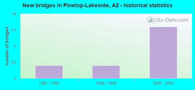
- New bridges - historical statistics
- 21980-1989
- 21990-1999
- 82000-2009


- Bridge Condition - Deck
- 8.3%Very good
- 75.0%Good
- 16.7%Satisfactory

- Bridge Condition - Superstructure
- 58.3%Very good
- 33.3%Good
- 8.3%Satisfactory

- Bridge Condition - Substructure
- 25.0%Very good
- 58.3%Good
- 16.7%Satisfactory

- Bridge Condition - Channel
- 55.6%Very good
- 33.3%Good
- 11.1%Fair
Find on map >> Show street view
Structure Number: 2505, Location: 1 mi E of Scottsdale Rd (Lat: 33.629700, Lng: -111.890300), Route carried "on" structure: State highway 101, Year Built: 1999, Status: Open, Structure Length: 6.86m (22.51ft), Average Daily Traffic: 157,576 (year 2017), Truck Traffic: 7%, Average Future Daily Traffic: 252,000 (year 2037), Design Load: HS 20, Features Intersected: Frank Lloyd Wright Blvd
Minimum Vertical Clearance: 7.62m (25.00ft), Kilometerpoint: 60.801, Lanes on structure: 10, Lanes under structure: 8, Owner: State Highway Agency, Approaching Roadway Width: 47.5m (155.8ft), Skew: 30 degrees, Material/Design: Prestressed concrete, Design/Construction: Box Beam or Girders - Single/Spread, Number Of Spans In Main Unit: 1, Length of Maximum Span: 67.1m (220.1ft), Curb-To-Curb Width: 47.9m (157.2ft), Out-to-Out Width: 49.7m (163.1ft)
Condition: Deck: Good, Superstructure: Good, Substructure: Satisfactory, Operating Rating: 89.8 metric tons, Method Used To Determine Operating Rating: Load Factor (LF), Inventory Rating: 61.7 metric tons, Method Used To Determine Inventory Rating: Load Factor (LF), Structural Evaluation: Equal to present minimum criteria, Deck Geometry: Superior to present desirable criteria, Underclear: Superior to present desirable criteria, Approach Roadway Alignment: Equal to present desirable criteria, Designated Inspection Frequency: Every 24 months, Inspection Date: October 2020, Deck Structure Type: Concrete Cast-file-Place, Wearing Surface/Protective System: Wearing Surface: Bituminous
Find on map >> Show street view
Structure Number: 2506, Location: 12 mi E I-17 & 13 mi (Lat: 33.630900, Lng: -111.890300), Route carried "on" structure: State highway 101, Year Built: 2000, Status: Open, Structure Length: 8.38m (27.49ft), Average Daily Traffic: 66,141 (year 2017), Truck Traffic: 7%, Average Future Daily Traffic: 66,151 (year 2038), Design Load: HS 20, Features Intersected: CAP Canal
Minimum Vertical Clearance: 30+ m (98+ ft), Kilometerpoint: 60.608, Lanes on structure: 5, Owner: State Highway Agency, Approaching Roadway Width: 23.8m (78.1ft), Skew: 1 degrees, Material/Design: Prestressed concrete continuous, Design/Construction: Stringer/Multi-beam, Number Of Spans In Main Unit: 3, Length of Maximum Span: 29.6m (97.1ft), Curb-To-Curb Width: 23.9m (78.4ft), Out-to-Out Width: 24.9m (81.7ft)
Condition: Deck: Good, Superstructure: Very good, Substructure: Good, Channel: Very good, Operating Rating: 89.8 metric tons, Method Used To Determine Operating Rating: Load Factor (LF), Inventory Rating: 34.5 metric tons, Method Used To Determine Inventory Rating: Load Factor (LF), Structural Evaluation: Better than present minimum criteria, Deck Geometry: Equal to present minimum criteria, Waterway Adequacy: Equal to present desirable criteria, Approach Roadway Alignment: Equal to present desirable criteria, Designated Inspection Frequency: Every 24 months, Inspection Date: October 2020, Deck Structure Type: Concrete Cast-file-Place, Wearing Surface/Protective System: Wearing Surface: Bituminous
Find on map >> Show street view
Structure Number: 2507, Location: 12 m E I-17 & 13 m N (Lat: 33.631000, Lng: -111.890500), Route carried "on" structure: State highway 101, Year Built: 2000, Status: Open, Structure Length: 8.38m (27.49ft), Average Daily Traffic: 68,907 (year 2017), Truck Traffic: 7%, Average Future Daily Traffic: 68,917 (year 2038), Design Load: HS 20, Features Intersected: CAP Canal
Minimum Vertical Clearance: 30+ m (98+ ft), Kilometerpoint: 60.608, Lanes on structure: 5, Owner: State Highway Agency, Approaching Roadway Width: 23.8m (78.1ft), Skew: 1 degrees, Material/Design: Prestressed concrete continuous, Design/Construction: Stringer/Multi-beam, Number Of Spans In Main Unit: 3, Length of Maximum Span: 29.6m (97.1ft), Curb-To-Curb Width: 23.9m (78.4ft), Out-to-Out Width: 24.9m (81.7ft)
Condition: Deck: Good, Superstructure: Very good, Substructure: Good, Channel: Very good, Operating Rating: 89.8 metric tons, Method Used To Determine Operating Rating: Load Factor (LF), Inventory Rating: 32.7 metric tons, Method Used To Determine Inventory Rating: Load Factor (LF), Structural Evaluation: Better than present minimum criteria, Deck Geometry: Equal to present minimum criteria, Waterway Adequacy: Equal to present desirable criteria, Approach Roadway Alignment: Equal to present desirable criteria, Designated Inspection Frequency: Every 24 months, Inspection Date: October 2020, Deck Structure Type: Concrete Cast-file-Place, Wearing Surface/Protective System: Wearing Surface: Bituminous
Find on map >> Show street view
Structure Number: 2508, Location: 2 mi E Scottsdale/Greenwa (Lat: 33.631300, Lng: -111.891000), Route carried "on" structure: ServiceState highway 101, Year Built: 2000, Status: Open, Structure Length: 3.05m (10.01ft), Average Daily Traffic: 18,815 (year 2019), Truck Traffic: 7%, Average Future Daily Traffic: 18,825 (year 2039), Design Load: HS 20, Features Intersected: CAP Canal, Facility Carried by Structure: CAP Canal Br WFR
Minimum Vertical Clearance: 30+ m (98+ ft), Kilometerpoint: 60.608, Lanes on structure: 3, Owner: State Highway Agency, Approaching Roadway Width: 8.8m (28.9ft), Skew: 1 degrees, Material/Design: Prestressed concrete, Design/Construction: Stringer/Multi-beam, Number Of Spans In Main Unit: 1, Length of Maximum Span: 29.0m (95.1ft), Curb-To-Curb Width: 12.0m (39.4ft), Out-to-Out Width: 13.0m (42.7ft)
Condition: Deck: Good, Superstructure: Very good, Substructure: Very good, Channel: Very good, Operating Rating: 89.8 metric tons, Method Used To Determine Operating Rating: Load Factor (LF), Inventory Rating: 39.9 metric tons, Method Used To Determine Inventory Rating: Load Factor (LF), Structural Evaluation: Equal to present desirable criteria, Deck Geometry: Meets minimum limits, Waterway Adequacy: Equal to present desirable criteria, Approach Roadway Alignment: Equal to present desirable criteria, Designated Inspection Frequency: Every 24 months, Inspection Date: Febuary 2020, Deck Structure Type: Concrete Cast-file-Place, Wearing Surface/Protective System: Wearing Surface: Monolithic Concrete
Find on map >> Show street view
Structure Number: 2509, Location: 2 mi E Scottsdale/Greenwa (Lat: 33.631100, Lng: -111.889800), Route carried "on" structure: ServiceState highway 101, Year Built: 1999, Status: Open, Structure Length: 3.05m (10.01ft), Average Daily Traffic: 22,563 (year 2019), Truck Traffic: 7%, Average Future Daily Traffic: 22,573 (year 2039), Design Load: HS 20, Features Intersected: CAP Canal, Facility Carried by Structure: CAP Canal Br EFR
Minimum Vertical Clearance: 30+ m (98+ ft), Kilometerpoint: 60.608, Lanes on structure: 4, Owner: State Highway Agency, Approaching Roadway Width: 15.8m (51.8ft), Skew: 1 degrees, Material/Design: Prestressed concrete, Design/Construction: Stringer/Multi-beam, Number Of Spans In Main Unit: 1, Length of Maximum Span: 29.0m (95.1ft), Curb-To-Curb Width: 15.6m (51.2ft), Out-to-Out Width: 16.6m (54.5ft)
Condition: Deck: Satisfactory, Superstructure: Very good, Substructure: Very good, Channel: Very good, Operating Rating: 89.8 metric tons, Method Used To Determine Operating Rating: Load Factor (LF), Inventory Rating: 43.5 metric tons, Method Used To Determine Inventory Rating: Load Factor (LF), Structural Evaluation: Equal to present desirable criteria, Deck Geometry: Meets minimum limits, Waterway Adequacy: Equal to present desirable criteria, Approach Roadway Alignment: Equal to present desirable criteria, Designated Inspection Frequency: Every 24 months, Inspection Date: Febuary 2020, Deck Structure Type: Concrete Cast-file-Place, Wearing Surface/Protective System: Wearing Surface: Monolithic Concrete
Find on map >> Show street view
Structure Number: 2639, Location: 15.6 mi E Jct SR 87 (Lat: 34.325900, Lng: -111.104900), Route carried "on" structure: State highway 260, Year Built: 2005, Status: Open, Structure Length: 3.96m (12.99ft), Average Daily Traffic: 3,044 (year 2017), Truck Traffic: 10%, Average Future Daily Traffic: 3,054 (year 2037), Design Load: HS 20, Features Intersected: Wash
Minimum Vertical Clearance: 30+ m (98+ ft), Kilometerpoint: 430.854, Lanes on structure: 2, Owner: State Highway Agency, Approaching Roadway Width: 11.6m (38.1ft), Material/Design: Prestressed concrete, Design/Construction: Stringer/Multi-beam, Number Of Spans In Main Unit: 1, Length of Maximum Span: 38.1m (125.0ft), Curb-To-Curb Width: 12.8m (42.0ft), Out-to-Out Width: 13.8m (45.3ft)
Condition: Deck: Good, Superstructure: Very good, Substructure: Good, Channel: Good, Operating Rating: 89.8 metric tons, Method Used To Determine Operating Rating: Load Factor (LF), Inventory Rating: 34.5 metric tons, Method Used To Determine Inventory Rating: Load Factor (LF), Structural Evaluation: Better than present minimum criteria, Deck Geometry: Equal to present desirable criteria, Waterway Adequacy: Equal to present desirable criteria, Approach Roadway Alignment: Equal to present desirable criteria, Designated Inspection Frequency: Every 24 months, Inspection Date: September 2020, Deck Structure Type: Concrete Cast-file-Place, Wearing Surface/Protective System: Wearing Surface: Bituminous, Deck Protection: Epoxy Coated Reinforcing
Find on map >> Show street view
Structure Number: 2683, Location: 0.3 mi E of McQueen/L 202 (Lat: 33.282639, Lng: -111.816556), Route carried "on" structure: State highway 202, Year Built: 2005, Status: Open, Structure Length: 4.02m (13.19ft), Average Daily Traffic: 155,763 (year 2018), Truck Traffic: 7%, Average Future Daily Traffic: 155,773 (year 2038), Design Load: HS 20, Features Intersected: Consolidated Canal
Minimum Vertical Clearance: 30.45m (99.90ft), Kilometerpoint: 74.513, Lanes on structure: 9, Owner: State Highway Agency, Approaching Roadway Width: 49.4m (162.1ft), Skew: 31 degrees, Material/Design: Prestressed concrete, Design/Construction: Box Beam or Girders - Single/Spread, Number Of Spans In Main Unit: 1, Length of Maximum Span: 38.4m (126.0ft), Curb-To-Curb Width: 49.6m (162.7ft), Out-to-Out Width: 51.5m (169.0ft)
Condition: Deck: Very good, Superstructure: Very good, Substructure: Good, Channel: Very good, Operating Rating: 89.8 metric tons, Method Used To Determine Operating Rating: Load Factor (LF), Inventory Rating: 52.6 metric tons, Method Used To Determine Inventory Rating: Load Factor (LF), Structural Evaluation: Better than present minimum criteria, Deck Geometry: Superior to present desirable criteria, Approach Roadway Alignment: Equal to present desirable criteria, Designated Inspection Frequency: Every 24 months, Inspection Date: January 2022, Deck Structure Type: Concrete Cast-file-Place, Wearing Surface/Protective System: Wearing Surface: Bituminous
Find on map >> Show street view
Structure Number: 2692, Location: 1 mi Eof Dobson Rd & 202L (Lat: 33.286600, Lng: -111.858800), Route carried "on" structure: City street , Year Built: 2004, Status: Open, Structure Length: 6.40m (21.00ft), Average Daily Traffic: 41,700 (year 2019), Truck Traffic: 8%, Average Future Daily Traffic: 41,710 (year 2039), Design Load: HS 20, Features Intersected: SR 202L, Facility Carried by Structure: Alma School Road
Minimum Vertical Clearance: 7.62m (25.00ft), Kilometerpoint: 0.000, Lanes on structure: 10, Lanes under structure: 8, Owner: State Highway Agency, Approaching Roadway Width: 38.7m (127.0ft), Skew: 20 degrees, Material/Design: Prestressed concrete continuous, Design/Construction: Box Beam or Girders - Multiple, Number Of Spans In Main Unit: 2, Length of Maximum Span: 31.4m (103.0ft), Curb or Sidewalk Widths: Left: 1.8m (5.9ft), Right: 1.8m (5.9ft), Curb-To-Curb Width: 38.7m (127.0ft), Out-to-Out Width: 44.0m (144.4ft)
Condition: Deck: Good, Superstructure: Good, Substructure: Good, Operating Rating: 58.1 metric tons, Method Used To Determine Operating Rating: Load Factor (LF), Inventory Rating: 34.5 metric tons, Method Used To Determine Inventory Rating: Load Factor (LF), Structural Evaluation: Better than present minimum criteria, Deck Geometry: Somewhat better than minimum adequacy, Underclear: Meets minimum limits, Approach Roadway Alignment: Equal to present desirable criteria, Designated Inspection Frequency: Every 24 months, Inspection Date: January 2022, Deck Structure Type: Concrete Cast-file-Place, Wearing Surface/Protective System: Wearing Surface: Monolithic Concrete
Find on map >> Show street view
Structure Number: 2737, Location: 24.3 mi E Jct SR 87 (Lat: 35.757269, Lng: -110.140753), Route carried "on" structure: State highway 264, Year Built: 2003, Status: Open, Structure Length: 8.08m (26.51ft), Average Daily Traffic: 1,968 (year 2017), Truck Traffic: 7%, Average Future Daily Traffic: 1,978 (year 2038), Design Load: HS 20, Features Intersected: Jeddito Wash
Minimum Vertical Clearance: 30+ m (98+ ft), Kilometerpoint: 657.481, Lanes on structure: 2, Owner: State Highway Agency, Approaching Roadway Width: 13.4m (44.0ft), Material/Design: Prestressed concrete continuous, Design/Construction: Stringer/Multi-beam, Number Of Spans In Main Unit: 3, Length of Maximum Span: 26.5m (86.9ft), Curb-To-Curb Width: 13.4m (44.0ft), Out-to-Out Width: 14.4m (47.2ft)
Condition: Deck: Good, Superstructure: Very good, Substructure: Very good, Channel: Good, Operating Rating: 89.8 metric tons, Method Used To Determine Operating Rating: Load Factor (LF), Inventory Rating: 34.5 metric tons, Method Used To Determine Inventory Rating: Load Factor (LF), Structural Evaluation: Equal to present desirable criteria, Deck Geometry: Equal to present desirable criteria, Waterway Adequacy: Superior to present desirable criteria, Approach Roadway Alignment: Equal to present desirable criteria, Designated Inspection Frequency: Every 24 months, Inspection Date: August 2020, Deck Structure Type: Concrete Cast-file-Place, Wearing Surface/Protective System: Wearing Surface: Monolithic Concrete
Find on map >> Show street view
Structure Number: 2801, Location: SR202 @ Williams Field Rd (Lat: 33.306833, Lng: -111.746944), Route carried "on" structure: City street , Year Built: 2006, Status: Open, Structure Length: 7.89m (25.89ft), Average Daily Traffic: 35,555 (year 2015), Truck Traffic: 5%, Average Future Daily Traffic: 35,565 (year 2040), Design Load: HS 20, Features Intersected: SR 202, Facility Carried by Structure: Williams Field Rd
Minimum Vertical Clearance: 7.62m (25.00ft), Kilometerpoint: 0.000, Lanes on structure: 10, Lanes under structure: 10, Owner: State Highway Agency, Approaching Roadway Width: 37.8m (124.0ft), Skew: 20 degrees, Material/Design: Prestressed concrete continuous, Design/Construction: Box Beam or Girders - Multiple, Number Of Spans In Main Unit: 2, Length of Maximum Span: 38.7m (127.0ft), Curb or Sidewalk Widths: Left: 1.8m (5.9ft), Right: 1.8m (5.9ft), Curb-To-Curb Width: 39.0m (128.0ft), Out-to-Out Width: 43.3m (142.1ft)
Condition: Deck: Good, Superstructure: Satisfactory, Substructure: Good, Operating Rating: 63.5 metric tons, Method Used To Determine Operating Rating: Load Factor (LF), Inventory Rating: 38.1 metric tons, Method Used To Determine Inventory Rating: Load Factor (LF), Structural Evaluation: Equal to present minimum criteria, Deck Geometry: Somewhat better than minimum adequacy, Underclear: Equal to present minimum criteria, Approach Roadway Alignment: Equal to present desirable criteria, Designated Inspection Frequency: Every 24 months, Inspection Date: March 2020, Deck Structure Type: Concrete Cast-file-Place, Wearing Surface/Protective System: Wearing Surface: Monolithic Concrete
Find on map >> Show street view
Structure Number: 8641, Location: 0.1 mi NE Billy Creek Dr (Lat: 34.150900, Lng: -109.959000), Route carried "on" structure: City street , Year Built: 1981, Status: Open, Structure Length: 1.52m (4.99ft), Average Daily Traffic: 720 (year 2018), Truck Traffic: 1%, Average Future Daily Traffic: 730 (year 2038), Design Load: HS 20, Features Intersected: Billy Creek, Facility Carried by Structure: Meadow Drive
Minimum Vertical Clearance: 30+ m (98+ ft), Kilometerpoint: 0.000, Lanes on structure: 2, Owner: City or Municipal Highway Agency, Approaching Roadway Width: 7.3m (24.0ft), Skew: 4 degrees, Material/Design: Steel, Design/Construction: Stringer/Multi-beam, Number Of Spans In Main Unit: 1, Length of Maximum Span: 14.9m (48.9ft), Curb-To-Curb Width: 9.0m (29.5ft), Out-to-Out Width: 9.5m (31.2ft)
Condition: Deck: Satisfactory, Superstructure: Good, Substructure: Satisfactory, Channel: Fair, Operating Rating: 61.7 metric tons, Method Used To Determine Operating Rating: Load Factor (LF), Inventory Rating: 37.2 metric tons, Method Used To Determine Inventory Rating: Load Factor (LF), Structural Evaluation: Equal to present minimum criteria, Deck Geometry: Somewhat better than minimum adequacy, Waterway Adequacy: Equal to present desirable criteria, Approach Roadway Alignment: Equal to present minimum criteria, Designated Inspection Frequency: Every 24 months, Inspection Date: May 2020, Deck Structure Type: Corrugated Steel, Wearing Surface/Protective System: Wearing Surface: Bituminous
Find on map >> Show street view
Structure Number: 8773, Location: 0.1 mi NE Jct SR 260 (Lat: 34.157464, Lng: -109.973175), Route carried "on" structure: City street , Year Built: 1983, Status: Open, Structure Length: 2.13m (6.99ft), Average Daily Traffic: 3,500 (year 2020), Truck Traffic: 10%, Average Future Daily Traffic: 3,510 (year 2040), Design Load: HS 20, Features Intersected: Billy Creek, Facility Carried by Structure: Porter Mountain Rd
Minimum Vertical Clearance: 30+ m (98+ ft), Kilometerpoint: 0.000, Lanes on structure: 2, Owner: City or Municipal Highway Agency, Approaching Roadway Width: 7.6m (24.9ft), Skew: 4 degrees, Material/Design: Concrete continuous, Design/Construction: Slab, Number Of Spans In Main Unit: 3, Length of Maximum Span: 7.6m (24.9ft), Curb-To-Curb Width: 9.2m (30.2ft), Out-to-Out Width: 10.1m (33.1ft)
Condition: Deck: Good, Superstructure: Good, Substructure: Good, Channel: Good, Operating Rating: 76.2 metric tons, Method Used To Determine Operating Rating: Load Factor (LF), Inventory Rating: 45.4 metric tons, Method Used To Determine Inventory Rating: Load Factor (LF), Structural Evaluation: Better than present minimum criteria, Deck Geometry: Meets minimum limits, Waterway Adequacy: Equal to present desirable criteria, Approach Roadway Alignment: Equal to present minimum criteria, Designated Inspection Frequency: Every 24 months, Inspection Date: May 2020, Deck Structure Type: Concrete Cast-file-Place, Wearing Surface/Protective System: Wearing Surface: Bituminous