Bridge Statistics for Pitcher, New York (NY)
Condition, Traffic, Stress, Structural Evaluation, Project Costs
- National Bridge Inventory (NBI) Statistics
- 12Number of bridges
- 75ft / 23.3mTotal length
- $9,715,000Total costs
- 5,098Total average daily traffic
- 620Total average daily truck traffic
- 7,135Total future (year 2036) average daily traffic
- National Bridge Inventory (NBI) Registered Bridges for Pitcher
- No street view available for this location
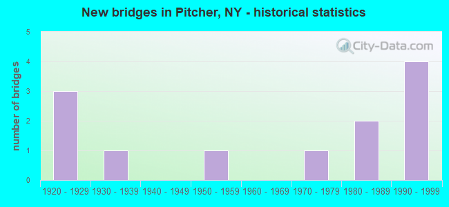
- New bridges - historical statistics
- 31920-1929
- 11930-1939
- 11950-1959
- 11970-1979
- 21980-1989
- 41990-1999

- Reconstructed bridges - Historical Statistics
- 21980-1989
- 01990-1999
- 02000-2009
- 12010-2019
- 12020-2022

- Bridge Condition - Deck
- 10.0%Excellent
- 20.0%Very good
- 20.0%Good
- 10.0%Satisfactory
- 30.0%Fair
- 10.0%Poor

- Bridge Condition - Superstructure
- 20.0%Very good
- 20.0%Good
- 40.0%Satisfactory
- 10.0%Fair
- 10.0%Poor

- Bridge Condition - Substructure
- 10.0%Excellent
- 30.0%Good
- 30.0%Satisfactory
- 20.0%Fair
- 10.0%Poor

- Bridge Condition - Channel
- 8.3%Excellent
- 8.3%Very good
- 8.3%Good
- 33.3%Satisfactory
- 25.0%Fair
- 16.7%Poor
Find on map >> Show street view
Structure Number: 101871, Location: 4.3 MI SW JCT CR42 & SH26 (Lat: 42.596761, Lng: -75.839244), Route carried "on" structure: State highway 26, Year Built: 1955, Year Reconstructed: 1994, Status: Open, Structure Length: 0.91m (2.99ft), Average Daily Traffic: 870 (year 2018), Truck Traffic: 13%, Average Future Daily Traffic: 1,218 (year 2038), Design Load: HS 25 or greater, Features Intersected: TRIB OTSELIC CRK
Minimum Vertical Clearance: 30+ m (98+ ft), Kilometerpoint: 3.990, Lanes on structure: 2, Base Highway Network: Yes, Owner: State Highway Agency, Approaching Roadway Width: 9.8m (32.2ft), Material/Design: Prestressed concrete, Design/Construction: Box Beam or Girders - Multiple, Number Of Spans In Main Unit: 1, Length of Maximum Span: 8.5m (27.9ft), Curb-To-Curb Width: 9.4m (30.8ft), Out-to-Out Width: 10.1m (33.1ft)
Condition: Deck: Good, Superstructure: Good, Substructure: Satisfactory, Channel: Satisfactory, Inventory Rating: 43.5 metric tons, Method Used To Determine Inventory Rating: Load Factor (LF), Structural Evaluation: Equal to present minimum criteria, Deck Geometry: Equal to present minimum criteria, Waterway Adequacy: Meets minimum limits, Approach Roadway Alignment: Equal to present desirable criteria, Length Of Structure Improvement: 0.91m (2.99ft), Designated Inspection Frequency: Every 24 months, Inspection Date: July 2020, Bridge Improvement Cost: $295,000, Roadway Improvement Cost: $173,000, Total Project Cost: $468,000 ( Estimate for 2021), Wearing Surface/Protective System: Wearing Surface: Integral Concrete
Find on map >> Show street view
Structure Number: 101872, Location: 2.6 MI SW JCT CR42 & SH26 (Lat: 42.609958, Lng: -75.829558), Route carried "on" structure: State highway 26, Year Built: 1924, Status: Open, Structure Length: 2.71m (8.89ft), Average Daily Traffic: 870 (year 2018), Truck Traffic: 13%, Average Future Daily Traffic: 1,218 (year 2038), Features Intersected: OTSELIC RIVER
Minimum Vertical Clearance: 30+ m (98+ ft), Kilometerpoint: 5.808, Lanes on structure: 2, Base Highway Network: Yes, Owner: State Highway Agency, Approaching Roadway Width: 8.5m (27.9ft), Skew: 3 degrees, Material/Design: Steel, Design/Construction: Stringer/Multi-beam, Number Of Spans In Main Unit: 2, Length of Maximum Span: 12.8m (42.0ft), Curb-To-Curb Width: 9.1m (29.9ft), Out-to-Out Width: 9.7m (31.8ft)
Condition: Deck: Fair, Superstructure: Poor, Substructure: Poor, Channel: Poor, Operating Rating: 58.1 metric tons, Method Used To Determine Operating Rating: Load Factor (LF), Inventory Rating: 34.5 metric tons, Method Used To Determine Inventory Rating: Load Factor (LF), Structural Evaluation: Meets minimum limits, Deck Geometry: Equal to present minimum criteria, Waterway Adequacy: Meets minimum limits, Approach Roadway Alignment: Equal to present desirable criteria, Length Of Structure Improvement: 2.71m (8.89ft), Designated Inspection Frequency: Every 24 months, Inspection Date: September 2021, Bridge Improvement Cost: $680,000, Roadway Improvement Cost: $398,000, Total Project Cost: $1,078,000 ( Estimate for 2021), Deck Structure Type: Concrete Cast-file-Place, Wearing Surface/Protective System: Wearing Surface: Bituminous
Find on map >> Show street view
Structure Number: 101873, Location: 1.2 MI SW JCT CR42 & SH26 (Lat: 42.626442, Lng: -75.814058), Route carried "on" structure: State highway 26, Year Built: 1924, Status: Open, Structure Length: 1.19m (3.90ft), Average Daily Traffic: 870 (year 2018), Truck Traffic: 13%, Average Future Daily Traffic: 1,218 (year 2038), Features Intersected: GLENN BROOK
Minimum Vertical Clearance: 30+ m (98+ ft), Kilometerpoint: 8.093, Lanes on structure: 2, Base Highway Network: Yes, Owner: State Highway Agency, Approaching Roadway Width: 8.5m (27.9ft), Material/Design: Steel, Design/Construction: Stringer/Multi-beam, Number Of Spans In Main Unit: 1, Length of Maximum Span: 10.6m (34.8ft), Curb-To-Curb Width: 10.2m (33.5ft), Out-to-Out Width: 10.8m (35.4ft)
Condition: Deck: Fair, Superstructure: Satisfactory, Substructure: Satisfactory, Channel: Satisfactory, Operating Rating: 59.0 metric tons, Method Used To Determine Operating Rating: Load Factor (LF), Inventory Rating: 29.0 metric tons, Method Used To Determine Inventory Rating: Load Factor (LF), Structural Evaluation: Equal to present minimum criteria, Deck Geometry: Equal to present minimum criteria, Waterway Adequacy: Somewhat better than minimum adequacy, Approach Roadway Alignment: Equal to present desirable criteria, Length Of Structure Improvement: 1.18m (3.87ft), Designated Inspection Frequency: Every 24 months, Inspection Date: June 2020, Bridge Improvement Cost: $435,000, Roadway Improvement Cost: $254,000, Total Project Cost: $689,000 ( Estimate for 2021), Deck Structure Type: Concrete Cast-file-Place, Wearing Surface/Protective System: Wearing Surface: Bituminous
Find on map >> Show street view
Structure Number: 101874, Location: 0.7 MI SW JCT CR42 & SH26 (Lat: 42.631294, Lng: -75.806456), Route carried "on" structure: State highway 26, Year Built: 1924, Year Reconstructed: 2018, Status: Open, Structure Length: 2.38m (7.81ft), Average Daily Traffic: 870 (year 2018), Truck Traffic: 13%, Average Future Daily Traffic: 1,218 (year 2038), Features Intersected: OTSELIC RIVER
Minimum Vertical Clearance: 30+ m (98+ ft), Kilometerpoint: 8.946, Lanes on structure: 2, Base Highway Network: Yes, Owner: State Highway Agency, Approaching Roadway Width: 9.4m (30.8ft), Material/Design: Steel, Design/Construction: Stringer/Multi-beam, Number Of Spans In Main Unit: 2, Length of Maximum Span: 11.5m (37.7ft), Curb-To-Curb Width: 9.5m (31.2ft), Out-to-Out Width: 10.1m (33.1ft)
Condition: Deck: Very good, Superstructure: Fair, Substructure: Fair, Channel: Fair, Operating Rating: 57.2 metric tons, Method Used To Determine Operating Rating: Load Factor (LF), Inventory Rating: 34.5 metric tons, Method Used To Determine Inventory Rating: Load Factor (LF), Structural Evaluation: Somewhat better than minimum adequacy, Deck Geometry: Equal to present minimum criteria, Waterway Adequacy: Somewhat better than minimum adequacy, Approach Roadway Alignment: Equal to present desirable criteria, Length Of Structure Improvement: 2.37m (7.78ft), Designated Inspection Frequency: Every 24 months, Inspection Date: September 2020, Bridge Improvement Cost: $667,000, Roadway Improvement Cost: $391,000, Total Project Cost: $1,058,000 ( Estimate for 2021), Deck Structure Type: Concrete Cast-file-Place, Wearing Surface/Protective System: Wearing Surface: Bituminous
Find on map >> Show street view
Structure Number: 107391, Location: 4.1 MI SW JCT SH 26 + SH (Lat: 42.593083, Lng: -75.843497), Route carried "on" structure: State highway 26, Year Built: 1986, Status: Open, Structure Length: 0.67m (2.20ft), Average Daily Traffic: 870 (year 2018), Truck Traffic: 13%, Average Future Daily Traffic: 1,218 (year 2038), Design Load: HS 20, Features Intersected: UNKNOWN CREEK
Minimum Vertical Clearance: 30+ m (98+ ft), Kilometerpoint: 3.443, Lanes on structure: 2, Base Highway Network: Yes, Owner: State Highway Agency, Approaching Roadway Width: 9.8m (32.2ft), Skew: 5 degrees, Material/Design: Concrete, Design/Construction: Culvert, Number Of Spans In Main Unit: 2, Length of Maximum Span: 3.0m (9.8ft), Curb-To-Curb Width: 11.7m (38.4ft), Out-to-Out Width: 17.6m (57.7ft)
Condition: Channel: Fair, Culverts: Satisfactory, Operating Rating: 74.5 metric tons, Method Used To Determine Operating Rating: Field evaluation and documented engineering judgment, Inventory Rating: 29.4 metric tons, Method Used To Determine Inventory Rating: Field evaluation and documented engineering judgment, Structural Evaluation: Equal to present minimum criteria, Deck Geometry: Better than present minimum criteria, Waterway Adequacy: Somewhat better than minimum adequacy, Approach Roadway Alignment: Equal to present minimum criteria, Length Of Structure Improvement: 0.67m (2.20ft), Designated Inspection Frequency: Every 24 months, Inspection Date: August 2020, Bridge Improvement Cost: $209,000, Roadway Improvement Cost: $123,000, Total Project Cost: $332,000 ( Estimate for 2021)
Find on map >> Show street view
Structure Number: 335126, Location: 1.8 MI SW OF PHARSALIA (Lat: 42.566008, Lng: -75.800756), Route carried "on" structure: Other road , Year Built: 1936, Year Reconstructed: 1987, Status: Open, Structure Length: 1.28m (4.20ft), Average Daily Traffic: 26 (year 2017), Truck Traffic: 5%, Average Future Daily Traffic: 36 (year 2037), Features Intersected: BRAKEL CREEK, Facility Carried by Structure: BURDICK HILL RD
Minimum Vertical Clearance: 30+ m (98+ ft), Kilometerpoint: 2.237, Lanes on structure: 1, Owner: County Highway Agency, Approaching Roadway Width: 4.6m (15.1ft), Material/Design: Steel, Design/Construction: Stringer/Multi-beam, Number Of Spans In Main Unit: 1, Length of Maximum Span: 11.2m (36.7ft), Curb-To-Curb Width: 5.2m (17.1ft), Out-to-Out Width: 6.1m (20.0ft)
Condition: Deck: Poor, Superstructure: Satisfactory, Substructure: Good, Channel: Very good, Operating Rating: 75.3 metric tons, Method Used To Determine Operating Rating: Allowable Stress (AS), Inventory Rating: 45.4 metric tons, Method Used To Determine Inventory Rating: Allowable Stress (AS), Structural Evaluation: Equal to present minimum criteria, Deck Geometry: High priority of corrective action, Waterway Adequacy: Equal to present desirable criteria, Approach Roadway Alignment: Meets minimum limits, Length Of Structure Improvement: 1.28m (4.20ft), Designated Inspection Frequency: Every 24 months, Inspection Date: April 2020, Bridge Improvement Cost: $314,000, Roadway Improvement Cost: $184,000, Total Project Cost: $499,000 ( Estimate for 2021), Deck Structure Type: Wood or Timber, Wearing Surface/Protective System: Wearing Surface: Bituminous
Find on map >> Show street view
Structure Number: 335127, Location: 2.7 MILES SW OF PHARSALIA (Lat: 42.557172, Lng: -75.816950), Route carried "on" structure: Other road , Year Built: 1991, Year Reconstructed: 2020, Status: Open, Structure Length: 1.77m (5.81ft), Average Daily Traffic: 36 (year 2019), Truck Traffic: 5%, Average Future Daily Traffic: 50 (year 2039), Design Load: HS 20+Mod, Features Intersected: BRAKEL CREEK, Facility Carried by Structure: BENTLEY ROAD
Minimum Vertical Clearance: 30+ m (98+ ft), Kilometerpoint: 1.384, Lanes on structure: 2, Owner: County Highway Agency, Approaching Roadway Width: 7.3m (24.0ft), Material/Design: Steel, Design/Construction: Stringer/Multi-beam, Number Of Spans In Main Unit: 1, Length of Maximum Span: 15.5m (50.9ft), Curb-To-Curb Width: 7.3m (24.0ft), Out-to-Out Width: 7.8m (25.6ft)
Condition: Deck: Excellent, Superstructure: Good, Substructure: Good, Channel: Good, Inventory Rating: 62.6 metric tons, Method Used To Determine Inventory Rating: Allowable Stress (AS), Structural Evaluation: Better than present minimum criteria, Deck Geometry: Equal to present minimum criteria, Waterway Adequacy: Somewhat better than minimum adequacy, Approach Roadway Alignment: Equal to present desirable criteria, Length Of Structure Improvement: 1.76m (5.77ft), Designated Inspection Frequency: Every 24 months, Inspection Date: May 2021, Bridge Improvement Cost: $470,000, Roadway Improvement Cost: $276,000, Total Project Cost: $746,000 ( Estimate for 2021), Deck Structure Type: Wood or Timber, Wearing Surface/Protective System: Wearing Surface: Bituminous
Find on map >> Show street view
Structure Number: 335129, Location: 0.1 MI NORTH OF PITCHER (Lat: 42.582317, Lng: -75.864753), Route carried "on" structure: County highway , Year Built: 1988, Status: Open, Structure Length: 2.62m (8.60ft), Average Daily Traffic: 458 (year 2016), Truck Traffic: 8%, Average Future Daily Traffic: 641 (year 2036), Design Load: HS 20, Features Intersected: OTSELIC RIVER, Facility Carried by Structure: COUNTY ROAD 12
Minimum Vertical Clearance: 30+ m (98+ ft), Kilometerpoint: 0.129, Lanes on structure: 2, Owner: County Highway Agency, Approaching Roadway Width: 6.1m (20.0ft), Material/Design: Prestressed concrete, Design/Construction: Box Beam or Girders - Multiple, Number Of Spans In Main Unit: 2, Length of Maximum Span: 12.8m (42.0ft), Curb-To-Curb Width: 7.1m (23.3ft), Out-to-Out Width: 8.0m (26.2ft)
Condition: Deck: Fair, Superstructure: Satisfactory, Substructure: Fair, Channel: Poor, Operating Rating: 81.6 metric tons, Method Used To Determine Operating Rating: Field evaluation and documented engineering judgment, Inventory Rating: 32.7 metric tons, Method Used To Determine Inventory Rating: Field evaluation and documented engineering judgment, Structural Evaluation: Somewhat better than minimum adequacy, Deck Geometry: Meets minimum limits, Waterway Adequacy: Meets minimum limits, Approach Roadway Alignment: Equal to present minimum criteria, Length Of Structure Improvement: 2.62m (8.60ft), Designated Inspection Frequency: Every 24 months, Inspection Date: June 2020, Bridge Improvement Cost: $630,000, Roadway Improvement Cost: $369,000, Total Project Cost: $999,000 ( Estimate for 2021), Wearing Surface/Protective System: Wearing Surface: Integral Concrete
Find on map >> Show street view
Structure Number: 335131, Location: 6.8 KM N JCT RTS 12 & 26 (Lat: 42.632283, Lng: -75.877428), Route carried "on" structure: County highway , Year Built: 1998, Status: Open, Structure Length: 2.99m (9.81ft), Average Daily Traffic: 73 (year 2016), Truck Traffic: 16%, Average Future Daily Traffic: 102 (year 2036), Design Load: HS 25 or greater, Features Intersected: MUD CREEK, Facility Carried by Structure: COUNTY ROAD 12A
Minimum Vertical Clearance: 30+ m (98+ ft), Kilometerpoint: 0.386, Lanes on structure: 2, Owner: County Highway Agency, Approaching Roadway Width: 7.3m (24.0ft), Material/Design: Steel, Design/Construction: Stringer/Multi-beam, Number Of Spans In Main Unit: 1, Length of Maximum Span: 29.2m (95.8ft), Curb-To-Curb Width: 7.2m (23.6ft), Out-to-Out Width: 7.8m (25.6ft)
Condition: Deck: Very good, Superstructure: Very good, Substructure: Excellent, Channel: Excellent, Operating Rating: 92.5 metric tons, Method Used To Determine Operating Rating: Load Factor (LF), Inventory Rating: 55.3 metric tons, Method Used To Determine Inventory Rating: Load Factor (LF), Structural Evaluation: Equal to present desirable criteria, Deck Geometry: Somewhat better than minimum adequacy, Waterway Adequacy: Equal to present desirable criteria, Approach Roadway Alignment: Equal to present desirable criteria, Length Of Structure Improvement: 2.98m (9.78ft), Designated Inspection Frequency: Every 24 months, Inspection Date: June 2020, Bridge Improvement Cost: $546,000, Roadway Improvement Cost: $320,000, Total Project Cost: $865,000 ( Estimate for 2021), Deck Structure Type: Concrete Cast-file-Place, Wearing Surface/Protective System: Wearing Surface: Integral Concrete, Deck Protection: Epoxy Coated Reinforcing
Find on map >> Show street view
Structure Number: 335132, Location: 1.9 MI NE OF PITCHER (Lat: 42.598467, Lng: -75.841122), Route carried "on" structure: Other road , Year Built: 1978, Status: Open, Structure Length: 2.35m (7.71ft), Average Daily Traffic: 46 (year 2017), Truck Traffic: 5%, Average Future Daily Traffic: 64 (year 2037), Features Intersected: OTSELIC RIVER, Facility Carried by Structure: TR 23 FOULDS RD
Minimum Vertical Clearance: 30+ m (98+ ft), Kilometerpoint: 0.515, Lanes on structure: 2, Owner: County Highway Agency, Approaching Roadway Width: 6.1m (20.0ft), Material/Design: Wood or Timber, Design/Construction: Stringer/Multi-beam, Number Of Spans In Main Unit: 1, Length of Maximum Span: 23.1m (75.8ft), Curb-To-Curb Width: 7.6m (24.9ft), Out-to-Out Width: 7.9m (25.9ft)
Condition: Deck: Satisfactory, Superstructure: Satisfactory, Substructure: Satisfactory, Channel: Fair, Operating Rating: 40.8 metric tons, Method Used To Determine Operating Rating: Allowable Stress (AS), Inventory Rating: 29.9 metric tons, Method Used To Determine Inventory Rating: Allowable Stress (AS), Structural Evaluation: Equal to present minimum criteria, Deck Geometry: Equal to present minimum criteria, Waterway Adequacy: Meets minimum limits, Approach Roadway Alignment: Equal to present desirable criteria, Length Of Structure Improvement: 2.34m (7.68ft), Designated Inspection Frequency: Every 24 months, Inspection Date: June 2020, Bridge Improvement Cost: $578,000, Roadway Improvement Cost: $339,000, Total Project Cost: $917,000 ( Estimate for 2021), Deck Structure Type: Wood or Timber, Wearing Surface/Protective System: Wearing Surface: Bituminous
Find on map >> Show street view
Structure Number: 335133, Location: .3 MI E OF SH 26/N.PITCHR (Lat: 42.619731, Lng: -75.815119), Route carried "on" structure: Other road , Year Built: 1995, Status: Open, Structure Length: 3.29m (10.79ft), Average Daily Traffic: 31 (year 2019), Truck Traffic: 5%, Average Future Daily Traffic: 43 (year 2039), Design Load: HS 25 or greater, Features Intersected: OTSELIC RIVER, Facility Carried by Structure: MILL ROAD
Minimum Vertical Clearance: 30+ m (98+ ft), Kilometerpoint: 0.177, Lanes on structure: 1, Owner: County Highway Agency, Approaching Roadway Width: 3.0m (9.8ft), Material/Design: Steel, Design/Construction: Truss - Thru, Number Of Spans In Main Unit: 1, Length of Maximum Span: 30.4m (99.7ft), Curb-To-Curb Width: 4.3m (14.1ft), Out-to-Out Width: 4.6m (15.1ft)
Condition: Deck: Good, Superstructure: Very good, Substructure: Good, Channel: Satisfactory, Operating Rating: 56.2 metric tons, Method Used To Determine Operating Rating: Load Factor (LF), Inventory Rating: 33.6 metric tons, Method Used To Determine Inventory Rating: Load Factor (LF), Structural Evaluation: Better than present minimum criteria, Deck Geometry: Equal to present minimum criteria, Waterway Adequacy: Equal to present minimum criteria, Approach Roadway Alignment: Equal to present desirable criteria, Length Of Structure Improvement: 3.10m (10.17ft), Designated Inspection Frequency: Every 24 months, Critical Feature Inspection Frequency: Every 24 months, Inspection Date: April 2021, Critical Feature Inspection Date: April 2021, Bridge Improvement Cost: $1,201,000, Roadway Improvement Cost: $703,000, Total Project Cost: $1,905,000 ( Estimate for 2021), Deck Structure Type: Wood or Timber, Wearing Surface/Protective System: Wearing Surface: Bituminous
Find on map >> Show street view
Structure Number: 335134, Location: 0.2 MI NW OF NYS RT 26 (Lat: 42.629631, Lng: -75.817872), Route carried "on" structure: Other road , Year Built: 1992, Status: Open, Structure Length: 1.16m (3.81ft), Average Daily Traffic: 78 (year 2019), Truck Traffic: 5%, Average Future Daily Traffic: 109 (year 2039), Design Load: HS 20, Features Intersected: GLEN BROOK, Facility Carried by Structure: KEMAK RD
Minimum Vertical Clearance: 30+ m (98+ ft), Kilometerpoint: 0.451, Lanes on structure: 2, Owner: County Highway Agency, Approaching Roadway Width: 4.9m (16.1ft), Skew: 5 degrees, Material/Design: Steel, Design/Construction: Culvert, Number Of Spans In Main Unit: 2, Length of Maximum Span: 5.4m (17.7ft)
Condition: Channel: Satisfactory, Culverts: Satisfactory, Operating Rating: 76.0 metric tons, Method Used To Determine Operating Rating: Field evaluation and documented engineering judgment, Inventory Rating: 29.4 metric tons, Method Used To Determine Inventory Rating: Field evaluation and documented engineering judgment, Structural Evaluation: Equal to present minimum criteria, Waterway Adequacy: Meets minimum limits, Approach Roadway Alignment: Equal to present desirable criteria, Length Of Structure Improvement: 1.15m (3.77ft), Designated Inspection Frequency: Every 24 months, Inspection Date: July 2020, Bridge Improvement Cost: $100,000, Roadway Improvement Cost: $59,000, Total Project Cost: $159,000 ( Estimate for 2021)