Bridge Statistics for Plantersville, Mississippi (MS)
Condition, Traffic, Stress, Structural Evaluation, Project Costs
- National Bridge Inventory (NBI) Statistics
- 14Number of bridges
- 138ft / 42.0mTotal length
- $1,225,000Total costs
- 15,704Total average daily traffic
- 1,404Total average daily truck traffic
- 23,855Total future (year 2036) average daily traffic
- National Bridge Inventory (NBI) Registered Bridges for Plantersville
- No street view available for this location
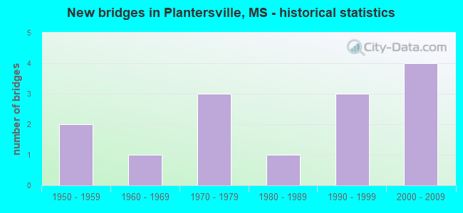
- New bridges - historical statistics
- 21950-1959
- 11960-1969
- 31970-1979
- 11980-1989
- 31990-1999
- 42000-2009

- Bridge Condition - Deck
- 57.1%Good
- 14.3%Satisfactory
- 28.6%Fair

- Bridge Condition - Superstructure
- 28.6%Very good
- 28.6%Good
- 14.3%Satisfactory
- 14.3%Fair
- 14.3%Poor

- Bridge Condition - Substructure
- 14.3%Very good
- 42.9%Good
- 28.6%Fair
- 14.3%Poor

- Bridge Condition - Channel
- 28.6%Very good
- 14.3%Good
- 35.7%Satisfactory
- 14.3%Fair
- 7.1%Poor

- Bridge Condition - Culverts
- 71.4%Good
- 14.3%Satisfactory
- 14.3%Fair
Find on map >> Show street view
Structure Number: 31000060411317, Location: 5.0 MI S SR 178 (Lat: 34.198839, Lng: -88.659011), Route carried "on" structure: US 6, Year Built: 1985, Status: Open, Structure Length: 1.05m (3.44ft), Average Daily Traffic: 2,500 (year 2020), Truck Traffic: 11%, Average Future Daily Traffic: 2,500 (year 2040), Design Load: HS 20, Features Intersected: GARRETT CREEK
Minimum Vertical Clearance: 30+ m (98+ ft), Kilometerpoint: 8.645, Lanes on structure: 2, Owner: State Highway Agency, Approaching Roadway Width: 12.2m (40.0ft), Skew: 1 degrees, Material/Design: Concrete, Design/Construction: Culvert, Number Of Spans In Main Unit: 2, Length of Maximum Span: 4.9m (16.1ft)
Condition: Channel: Satisfactory, Culverts: Good, Inventory Rating: 58.5 metric tons, Method Used To Determine Inventory Rating: Load Factor (LF), Structural Evaluation: Better than present minimum criteria, Waterway Adequacy: Superior to present desirable criteria, Approach Roadway Alignment: Equal to present desirable criteria, Designated Inspection Frequency: Every 24 months, Inspection Date: November 2020
Find on map >> Show street view
Structure Number: 31000060411348, Location: 7.8 MI S SR 178 (Lat: 34.162311, Lng: -88.647781), Route carried "on" structure: State highway 6, Year Built: 1955, Status: Open, Structure Length: 1.04m (3.41ft), Average Daily Traffic: 2,500 (year 2020), Truck Traffic: 11%, Average Future Daily Traffic: 2,500 (year 2040), Design Load: H 15, Features Intersected: SMITH CREEK
Minimum Vertical Clearance: 30+ m (98+ ft), Kilometerpoint: 13.044, Lanes on structure: 2, Owner: State Highway Agency, Approaching Roadway Width: 7.3m (24.0ft), Skew: 1 degrees, Material/Design: Concrete, Design/Construction: Culvert, Number Of Spans In Main Unit: 2, Length of Maximum Span: 4.9m (16.1ft)
Condition: Channel: Fair, Culverts: Fair, Operating Rating: 59.4 metric tons, Method Used To Determine Operating Rating: Load Factor (LF), Inventory Rating: 36.0 metric tons, Method Used To Determine Inventory Rating: Load Factor (LF), Structural Evaluation: Somewhat better than minimum adequacy, Waterway Adequacy: Equal to present minimum criteria, Approach Roadway Alignment: Equal to present desirable criteria, Designated Inspection Frequency: Every 24 months, Inspection Date: November 2020
Find on map >> Show street view
Structure Number: SA4100000000142, Location: SEC 14 T10S R 6E B (Lat: 34.207194, Lng: -88.640750), Route carried "on" structure: County highway 3127, Year Built: 1964, Status: Posted for load, Structure Length: 1.07m (3.51ft), Average Daily Traffic: 10 (year 2021), Average Future Daily Traffic: 15 (year 2043), Features Intersected: GARRETT CREEK, Facility Carried by Structure: CR 1027
Minimum Vertical Clearance: 30+ m (98+ ft), Kilometerpoint: 0.160, Lanes on structure: 1, Owner: County Highway Agency, Approaching Roadway Width: 4.4m (14.4ft), Material/Design: Steel, Design/Construction: Girder and Floorbeam System, Number Of Spans In Main Unit: 1, Length of Maximum Span: 9.4m (30.8ft), Curb-To-Curb Width: 4.7m (15.4ft), Out-to-Out Width: 4.7m (15.4ft)
Condition: Deck: Satisfactory, Superstructure: Poor, Substructure: Fair, Channel: Poor, Operating Rating: 9.9 metric tons, Method Used To Determine Operating Rating: Load Factor (LF), Inventory Rating: 5.9 metric tons, Method Used To Determine Inventory Rating: Load Factor (LF), Structural Evaluation: High priority of replacement, Deck Geometry: Better than present minimum criteria, Waterway Adequacy: Equal to present desirable criteria, Approach Roadway Alignment: Equal to present desirable criteria, Bridge Posting: Required (Relationship of Operating Rating to Maximum Legal Load: > 39.9% below), Length Of Structure Improvement: 1.74m (5.71ft), Designated Inspection Frequency: Every 12 months, Critical Feature Inspection Frequency: Every 12 months, Inspection Date: November 2021, Critical Feature Inspection Date: November 2021, Bridge Improvement Cost: $155,000, Roadway Improvement Cost: $124,000, Total Project Cost: $279,000 ( Estimate for 2021), Deck Structure Type: Wood or Timber, Wearing Surface/Protective System: Wearing Surface: Gravel
Find on map >> Show street view
Structure Number: SA4100000000144, Location: SEC 21 T10S R 6E B (Lat: 34.197722, Lng: -88.682806), Route carried "on" structure: County highway 2840, Year Built: 2008, Status: Open, Structure Length: 13.11m (43.01ft), Average Daily Traffic: 2,100 (year 2022), Truck Traffic: 8%, Average Future Daily Traffic: 3,150 (year 2040), Design Load: HS 20, Features Intersected: TOWN CREEK, Facility Carried by Structure: CR 814
Minimum Vertical Clearance: 30+ m (98+ ft), Kilometerpoint: 2.253, Lanes on structure: 2, Owner: County Highway Agency, Approaching Roadway Width: 6.7m (22.0ft), Material/Design: Prestressed concrete, Design/Construction: Stringer/Multi-beam, Number Of Spans In Main Unit: 7, Length of Maximum Span: 33.5m (109.9ft), Curb or Sidewalk Widths: Left: 0.5m (1.6ft), Right: 0.5m (1.6ft), Curb-To-Curb Width: 9.1m (29.9ft), Out-to-Out Width: 10.1m (33.1ft)
Condition: Deck: Good, Superstructure: Very good, Substructure: Very good, Channel: Very good, Operating Rating: 57.8 metric tons, Method Used To Determine Operating Rating: Load Factor (LF), Inventory Rating: 25.2 metric tons, Method Used To Determine Inventory Rating: Load Factor (LF), Structural Evaluation: Equal to present minimum criteria, Deck Geometry: Meets minimum limits, Waterway Adequacy: Equal to present desirable criteria, Approach Roadway Alignment: Equal to present desirable criteria, Designated Inspection Frequency: Every 24 months, Inspection Date: January 2022, Deck Structure Type: Concrete Cast-file-Place, Wearing Surface/Protective System: Wearing Surface: Monolithic Concrete
Find on map >> Show street view
Structure Number: SA4100000000145, Location: SEC 21 T10S R 6E B (Lat: 34.200611, Lng: -88.679083), Route carried "on" structure: County highway 2840, Year Built: 2008, Status: Open, Structure Length: 4.70m (15.42ft), Average Daily Traffic: 219 (year 2022), Truck Traffic: 8%, Average Future Daily Traffic: 3,150 (year 2040), Design Load: HS 20, Features Intersected: RELIEF FOR TOWN CK, Facility Carried by Structure: CR 814
Minimum Vertical Clearance: 30+ m (98+ ft), Kilometerpoint: 2.735, Lanes on structure: 2, Owner: County Highway Agency, Approaching Roadway Width: 6.7m (22.0ft), Material/Design: Concrete, Design/Construction: Channel Beam, Number Of Spans In Main Unit: 5, Length of Maximum Span: 9.4m (30.8ft), Curb or Sidewalk Widths: Left: 0.5m (1.6ft), Right: 0.5m (1.6ft), Curb-To-Curb Width: 9.1m (29.9ft), Out-to-Out Width: 10.1m (33.1ft)
Condition: Deck: Good, Superstructure: Good, Substructure: Good, Channel: Very good, Operating Rating: 59.8 metric tons, Method Used To Determine Operating Rating: Load Factor (LF), Inventory Rating: 36.0 metric tons, Method Used To Determine Inventory Rating: Load Factor (LF), Structural Evaluation: Better than present minimum criteria, Deck Geometry: Equal to present minimum criteria, Waterway Adequacy: Equal to present desirable criteria, Approach Roadway Alignment: Equal to present desirable criteria, Designated Inspection Frequency: Every 24 months, Inspection Date: January 2022, Deck Structure Type: Concrete Precast Panels, Wearing Surface/Protective System: Wearing Surface: Monolithic Concrete
Find on map >> Show street view
Structure Number: SA4100000000146, Location: SEC 21 T10S R 6E B (Lat: 34.202944, Lng: -88.676111), Route carried "on" structure: County highway 2840, Year Built: 2007, Status: Open, Structure Length: 8.46m (27.76ft), Average Daily Traffic: 2,105 (year 2022), Truck Traffic: 9%, Average Future Daily Traffic: 3,150 (year 2040), Design Load: HS 20, Features Intersected: RELIEF FOR TOWN CK, Facility Carried by Structure: CR 814
Minimum Vertical Clearance: 30+ m (98+ ft), Kilometerpoint: 3.218, Lanes on structure: 2, Owner: County Highway Agency, Approaching Roadway Width: 6.7m (22.0ft), Material/Design: Concrete, Design/Construction: Channel Beam, Number Of Spans In Main Unit: 9, Length of Maximum Span: 9.4m (30.8ft), Curb or Sidewalk Widths: Left: 0.5m (1.6ft), Right: 0.5m (1.6ft), Curb-To-Curb Width: 9.1m (29.9ft), Out-to-Out Width: 10.1m (33.1ft)
Condition: Deck: Good, Superstructure: Good, Substructure: Good, Channel: Very good, Operating Rating: 59.8 metric tons, Method Used To Determine Operating Rating: Load Factor (LF), Inventory Rating: 36.0 metric tons, Method Used To Determine Inventory Rating: Load Factor (LF), Structural Evaluation: Better than present minimum criteria, Deck Geometry: Meets minimum limits, Waterway Adequacy: Equal to present desirable criteria, Approach Roadway Alignment: Equal to present desirable criteria, Designated Inspection Frequency: Every 24 months, Inspection Date: January 2022, Deck Structure Type: Concrete Precast Panels, Wearing Surface/Protective System: Wearing Surface: Monolithic Concrete
Find on map >> Show street view
Structure Number: SA4100000000147, Location: SEC 22 T10S R 6E B (Lat: 34.206333, Lng: -88.658194), Route carried "on" structure: County highway 2840, Year Built: 1974, Status: Open, Structure Length: 1.04m (3.41ft), Average Daily Traffic: 1,905 (year 2022), Truck Traffic: 8%, Average Future Daily Traffic: 2,850 (year 2040), Design Load: HS 20, Features Intersected: LITTLE GARRETT CREEK, Facility Carried by Structure: CR 814
Minimum Vertical Clearance: 30+ m (98+ ft), Kilometerpoint: 6.115, Lanes on structure: 2, Owner: County Highway Agency, Approaching Roadway Width: 6.7m (22.0ft), Skew: 1 degrees, Material/Design: Concrete, Design/Construction: Culvert, Number Of Spans In Main Unit: 2, Length of Maximum Span: 4.9m (16.1ft)
Condition: Channel: Satisfactory, Culverts: Good, Operating Rating: 46.1 metric tons, Method Used To Determine Operating Rating: Load Factor (LF), Inventory Rating: 27.5 metric tons, Method Used To Determine Inventory Rating: Load Factor (LF), Structural Evaluation: Equal to present minimum criteria, Waterway Adequacy: Equal to present desirable criteria, Approach Roadway Alignment: Equal to present desirable criteria, Designated Inspection Frequency: Every 24 months, Inspection Date: January 2022
Find on map >> Show street view
Structure Number: SA4100000000148, Location: SEC 23 T10S R 6E B (Lat: 34.206417, Lng: -88.646056), Route carried "on" structure: County highway 2840, Year Built: 1974, Status: Open, Structure Length: 1.34m (4.40ft), Average Daily Traffic: 1,905 (year 2022), Truck Traffic: 8%, Average Future Daily Traffic: 2,850 (year 2040), Design Load: HS 20, Features Intersected: GARRETT CREEK, Facility Carried by Structure: CR 814
Minimum Vertical Clearance: 30+ m (98+ ft), Kilometerpoint: 7.563, Lanes on structure: 2, Owner: County Highway Agency, Approaching Roadway Width: 6.7m (22.0ft), Skew: 3 degrees, Material/Design: Concrete, Design/Construction: Culvert, Number Of Spans In Main Unit: 1, Length of Maximum Span: 6.1m (20.0ft)
Condition: Channel: Good, Culverts: Good, Operating Rating: 62.1 metric tons, Method Used To Determine Operating Rating: Load Factor (LF), Inventory Rating: 37.3 metric tons, Method Used To Determine Inventory Rating: Load Factor (LF), Structural Evaluation: Better than present minimum criteria, Waterway Adequacy: Equal to present desirable criteria, Approach Roadway Alignment: Equal to present desirable criteria, Designated Inspection Frequency: Every 24 months, Inspection Date: January 2022
Find on map >> Show street view
Structure Number: SA4100000000149, Location: SEC 24 T10S R 6E B (Lat: 34.191778, Lng: -88.615278), Route carried "on" structure: County highway 2840, Year Built: 1958, Status: Open, Structure Length: 0.85m (2.79ft), Average Daily Traffic: 1,100 (year 2022), Truck Traffic: 8%, Average Future Daily Traffic: 1,650 (year 2040), Design Load: HS 20, Features Intersected: SMITH CREEK, Facility Carried by Structure: CR 814
Minimum Vertical Clearance: 30+ m (98+ ft), Kilometerpoint: 9.816, Lanes on structure: 2, Owner: County Highway Agency, Approaching Roadway Width: 7.3m (24.0ft), Material/Design: Concrete, Design/Construction: Culvert, Number Of Spans In Main Unit: 2, Length of Maximum Span: 3.7m (12.1ft)
Condition: Channel: Satisfactory, Culverts: Satisfactory, Operating Rating: 51.3 metric tons, Method Used To Determine Operating Rating: Load Factor (LF), Inventory Rating: 30.7 metric tons, Method Used To Determine Inventory Rating: Load Factor (LF), Structural Evaluation: Equal to present minimum criteria, Waterway Adequacy: Better than present minimum criteria, Approach Roadway Alignment: Equal to present minimum criteria, Designated Inspection Frequency: Every 24 months, Inspection Date: January 2022
Find on map >> Show street view
Structure Number: SA4100000000151, Location: SEC 35 T10S R 6E (Lat: 34.173444, Lng: -88.633333), Route carried "on" structure: County highway 274, Year Built: 1991, Status: Posted for load, Structure Length: 2.39m (7.84ft), Average Daily Traffic: 40 (year 2021), Average Future Daily Traffic: 60 (year 2043), Features Intersected: SMITH CREEK, Facility Carried by Structure: CR 1093
Minimum Vertical Clearance: 30+ m (98+ ft), Kilometerpoint: 0.482, Lanes on structure: 2, Owner: County Highway Agency, Approaching Roadway Width: 4.9m (16.1ft), Skew: 2 degrees, Material/Design: Steel, Design/Construction: Girder and Floorbeam System, Number Of Spans In Main Unit: 1, Number Of Approach Spans: 2, Length of Maximum Span: 12.3m (40.4ft), Curb or Sidewalk Widths: Left: 0.3m (1.0ft), Right: 0.3m (1.0ft), Curb-To-Curb Width: 8.1m (26.6ft), Out-to-Out Width: 8.5m (27.9ft)
Condition: Deck: Fair, Superstructure: Satisfactory, Substructure: Fair, Channel: Fair, Operating Rating: 31.4 metric tons, Method Used To Determine Operating Rating: Load Factor (LF), Inventory Rating: 22.3 metric tons, Method Used To Determine Inventory Rating: Load Factor (LF), Structural Evaluation: Somewhat better than minimum adequacy, Deck Geometry: Equal to present minimum criteria, Waterway Adequacy: Equal to present desirable criteria, Approach Roadway Alignment: Equal to present minimum criteria, Bridge Posting: Required (Relationship of Operating Rating to Maximum Legal Load: 0.1 - 9.9% below), Length Of Structure Improvement: 3.25m (10.66ft), Designated Inspection Frequency: Every 12 months, Critical Feature Inspection Frequency: Every 12 months, Inspection Date: December 2021, Critical Feature Inspection Date: December 2021, Bridge Improvement Cost: $296,000, Roadway Improvement Cost: $237,000, Total Project Cost: $533,000 ( Estimate for 2021), Deck Structure Type: Wood or Timber, Wearing Surface/Protective System: Wearing Surface: Bituminous
Find on map >> Show street view
Structure Number: SA4100000000152, Location: SEC 36 T10S R 6E B (Lat: 34.162194, Lng: -88.619000), Route carried "on" structure: County highway 285, Year Built: 1999, Status: Open, Structure Length: 1.14m (3.74ft), Average Daily Traffic: 100 (year 2016), Average Future Daily Traffic: 150 (year 2036), Design Load: HS 20, Features Intersected: CARMICHAEL CREEK, Facility Carried by Structure: CR 598
Minimum Vertical Clearance: 30+ m (98+ ft), Kilometerpoint: 1.126, Lanes on structure: 2, Owner: County Highway Agency, Approaching Roadway Width: 6.7m (22.0ft), Skew: 4 degrees, Material/Design: Concrete, Design/Construction: Culvert, Number Of Spans In Main Unit: 2, Length of Maximum Span: 3.7m (12.1ft)
Condition: Channel: Good, Culverts: Good, Operating Rating: 68.3 metric tons, Method Used To Determine Operating Rating: Load Factor (LF), Inventory Rating: 40.9 metric tons, Method Used To Determine Inventory Rating: Load Factor (LF), Structural Evaluation: Better than present minimum criteria, Waterway Adequacy: Equal to present desirable criteria, Approach Roadway Alignment: Equal to present desirable criteria, Designated Inspection Frequency: Every 24 months, Inspection Date: Febuary 2020
Find on map >> Show street view
Structure Number: SA410000000016, Location: SEC 30 T10S R 7E B (Lat: 34.188972, Lng: -88.601167), Route carried "on" structure: County highway 2840, Year Built: 1994, Status: Open, Structure Length: 3.11m (10.20ft), Average Daily Traffic: 1,100 (year 2022), Truck Traffic: 8%, Average Future Daily Traffic: 1,650 (year 2040), Design Load: HS 20, Features Intersected: CARMICHAEL CREEK, Facility Carried by Structure: CR 814
Minimum Vertical Clearance: 30+ m (98+ ft), Kilometerpoint: 11.104, Lanes on structure: 2, Owner: County Highway Agency, Approaching Roadway Width: 7.3m (24.0ft), Material/Design: Prestressed concrete, Design/Construction: Stringer/Multi-beam, Number Of Spans In Main Unit: 3, Length of Maximum Span: 12.2m (40.0ft), Curb or Sidewalk Widths: Left: 0.5m (1.6ft), Right: 0.5m (1.6ft), Curb-To-Curb Width: 9.1m (29.9ft), Out-to-Out Width: 10.1m (33.1ft)
Condition: Deck: Good, Superstructure: Very good, Substructure: Good, Channel: Satisfactory, Operating Rating: 69.3 metric tons, Method Used To Determine Operating Rating: Load Factor (LF), Inventory Rating: 41.5 metric tons, Method Used To Determine Inventory Rating: Load Factor (LF), Structural Evaluation: Better than present minimum criteria, Deck Geometry: Somewhat better than minimum adequacy, Waterway Adequacy: Equal to present desirable criteria, Approach Roadway Alignment: Equal to present desirable criteria, Designated Inspection Frequency: Every 24 months, Inspection Date: January 2022, Deck Structure Type: Concrete Cast-file-Place, Wearing Surface/Protective System: Wearing Surface: Monolithic Concrete
Find on map >> Show street view
Structure Number: SA4100000000161, Location: SEC 31 T10S R 7E (Lat: 34.163611, Lng: -88.614167), Route carried "on" structure: County highway 279, Year Built: 2005, Status: Open, Structure Length: 0.83m (2.72ft), Average Daily Traffic: 80 (year 2016), Average Future Daily Traffic: 120 (year 2036), Design Load: HS 20, Features Intersected: CARMICHAEL CREEK E FORK, Facility Carried by Structure: CR 1201
Minimum Vertical Clearance: 30+ m (98+ ft), Kilometerpoint: 0.160, Lanes on structure: 2, Owner: County Highway Agency, Approaching Roadway Width: 6.7m (22.0ft), Skew: 1 degrees, Material/Design: Concrete, Design/Construction: Culvert, Number Of Spans In Main Unit: 2, Length of Maximum Span: 3.7m (12.1ft)
Condition: Channel: Very good, Culverts: Good, Operating Rating: 69.9 metric tons, Method Used To Determine Operating Rating: Load Factor (LF), Inventory Rating: 41.8 metric tons, Method Used To Determine Inventory Rating: Load Factor (LF), Structural Evaluation: Better than present minimum criteria, Waterway Adequacy: Equal to present desirable criteria, Approach Roadway Alignment: Equal to present desirable criteria, Designated Inspection Frequency: Every 24 months, Inspection Date: Febuary 2020
Find on map >> Show street view
Structure Number: SA4100000000162, Location: SEC_31_T10S_R 7E (Lat: 34.173028, Lng: -88.605556), Route carried "on" structure: County highway 281, Year Built: 1978, Status: Posted for load, Structure Length: 1.86m (6.10ft), Average Daily Traffic: 40 (year 2021), Average Future Daily Traffic: 60 (year 2043), Features Intersected: CARMICHAEL CREEK, Facility Carried by Structure: CR 712
Minimum Vertical Clearance: 30+ m (98+ ft), Kilometerpoint: 0.965, Lanes on structure: 1, Owner: County Highway Agency, Approaching Roadway Width: 4.6m (15.1ft), Material/Design: Steel, Design/Construction: Girder and Floorbeam System, Number Of Spans In Main Unit: 1, Length of Maximum Span: 18.3m (60.0ft), Curb-To-Curb Width: 4.5m (14.8ft), Out-to-Out Width: 4.9m (16.1ft)
Condition: Deck: Fair, Superstructure: Fair, Substructure: Poor, Channel: Satisfactory, Operating Rating: 4.9 metric tons, Method Used To Determine Operating Rating: Load Factor (LF), Inventory Rating: 2.9 metric tons, Method Used To Determine Inventory Rating: Load Factor (LF), Structural Evaluation: High priority of replacement, Deck Geometry: Equal to present minimum criteria, Waterway Adequacy: Equal to present desirable criteria, Approach Roadway Alignment: High priority of corrective action, Bridge Posting: Required (Relationship of Operating Rating to Maximum Legal Load: > 39.9% below), Length Of Structure Improvement: 2.58m (8.46ft), Designated Inspection Frequency: Every 12 months, Critical Feature Inspection Frequency: Every 12 months, Inspection Date: November 2021, Critical Feature Inspection Date: November 2021, Bridge Improvement Cost: $229,000, Roadway Improvement Cost: $184,000, Total Project Cost: $413,000 ( Estimate for 2021), Deck Structure Type: Wood or Timber, Wearing Surface/Protective System: Wearing Surface: Bituminous