Bridge Statistics for Platte City, Missouri (MO)
Condition, Traffic, Stress, Structural Evaluation, Project Costs
- National Bridge Inventory (NBI) Statistics
- 21Number of bridges
- 374ft / 114mTotal length
- 169,575Total average daily traffic
- 26,542Total average daily truck traffic
- National Bridge Inventory (NBI) Registered Bridges for Platte City
- No street view available for this location
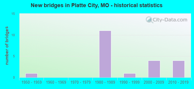
- New bridges - historical statistics
- 11950-1959
- 111980-1989
- 11990-1999
- 42000-2009
- 42010-2019


- Bridge Condition - Deck
- 62.5%Good
- 37.5%Satisfactory

- Bridge Condition - Superstructure
- 12.5%Very good
- 62.5%Good
- 25.0%Satisfactory

- Bridge Condition - Substructure
- 12.5%Very good
- 25.0%Good
- 25.0%Satisfactory
- 37.5%Fair

- Bridge Condition - Channel
- 12.5%Very good
- 62.5%Satisfactory
- 25.0%Fair

- Bridge Condition - Culverts
- 75.0%Good
- 25.0%Satisfactory
Find on map >> Show street view
Structure Number: 2795, Location: S 7 T 52 N R 34 W (Lat: 39.339208, Lng: -94.752119), Route carried "on" structure: County highway , Year Built: 1984, Status: Open, Structure Length: 8.23m (27.00ft), Average Daily Traffic: 1,464 (year 2021), Truck Traffic: 10%, Average Future Daily Traffic: 2,635 (year 2041), Design Load: HS 20+Mod, Features Intersected: IS 435, Facility Carried by Structure: NW 136TH ST E
Minimum Vertical Clearance: 30+ m (98+ ft), Kilometerpoint: 2.337, Lanes on structure: 2, Lanes under structure: 4, Owner: State Highway Agency, Approaching Roadway Width: 12.2m (40.0ft), Skew: 1 degrees, Material/Design: Steel continuous, Design/Construction: Stringer/Multi-beam, Number Of Spans In Main Unit: 4, Length of Maximum Span: 26.5m (86.9ft), Curb or Sidewalk Widths: Left: 0.2m (0.7ft), Right: 0.2m (0.7ft), Curb-To-Curb Width: 13.0m (42.7ft), Out-to-Out Width: 13.9m (45.6ft)
Condition: Deck: Good, Superstructure: Good, Substructure: Satisfactory, Operating Rating: 55.8 metric tons, Method Used To Determine Operating Rating: Allowable Stress (AS), Inventory Rating: 40.5 metric tons, Method Used To Determine Inventory Rating: Allowable Stress (AS), Structural Evaluation: Equal to present minimum criteria, Deck Geometry: Better than present minimum criteria, Underclear: Better than present minimum criteria, Approach Roadway Alignment: Equal to present desirable criteria, Designated Inspection Frequency: Every 24 months, Inspection Date: October 2020, Deck Structure Type: Concrete Cast-file-Place, Wearing Surface/Protective System: Wearing Surface: Monolithic Concrete, Deck Protection: Epoxy Coated Reinforcing
Find on map >> Show street view
Structure Number: 2893, Location: S 16 T 53 N R 34 W (Lat: 39.401086, Lng: -94.726886), Route carried "on" structure: County highway 130, Year Built: 2002, Status: Open, Structure Length: 9.85m (32.32ft), Average Daily Traffic: 200 (year 2020), Truck Traffic: 10%, Average Future Daily Traffic: 370 (year 2040), Design Load: HS 20, Features Intersected: PLATTE RVR, Facility Carried by Structure: INTER-URBAN RVR
Minimum Vertical Clearance: 30+ m (98+ ft), Kilometerpoint: 0.000, Lanes on structure: 2, Owner: County Highway Agency, Approaching Roadway Width: 7.3m (24.0ft), Material/Design: Steel continuous, Design/Construction: Stringer/Multi-beam, Number Of Spans In Main Unit: 3, Length of Maximum Span: 42.7m (140.1ft), Curb-To-Curb Width: 7.3m (24.0ft), Out-to-Out Width: 7.4m (24.3ft)
Condition: Deck: Good, Superstructure: Satisfactory, Substructure: Good, Channel: Satisfactory, Operating Rating: 55.8 metric tons, Method Used To Determine Operating Rating: Load Factor (LF), Inventory Rating: 33.3 metric tons, Method Used To Determine Inventory Rating: Load Factor (LF), Structural Evaluation: Equal to present minimum criteria, Deck Geometry: Somewhat better than minimum adequacy, Waterway Adequacy: Superior to present desirable criteria, Approach Roadway Alignment: Equal to present desirable criteria, Designated Inspection Frequency: Every 24 months, Inspection Date: April 2020, Deck Structure Type: Concrete Cast-file-Place, Wearing Surface/Protective System: Wearing Surface: Integral Concrete
Find on map >> Show street view
Structure Number: 2906, Location: S 5 T 52 N R 34 W (Lat: 39.346133, Lng: -94.748436), Route carried "on" structure: Ramp State highway , Year Built: 1985, Status: Open, Structure Length: 12.68m (41.60ft), Average Daily Traffic: 4,903 (year 2021), Truck Traffic: 18%, Average Future Daily Traffic: 10,051 (year 2041), Design Load: HS 20+Mod, Features Intersected: IS 29, Facility Carried by Structure: RP IS435S TO IS29N
Minimum Vertical Clearance: 30+ m (98+ ft), Kilometerpoint: 0.454, Lanes on structure: 1, Lanes under structure: 4, Base Highway Network: Yes, Owner: State Highway Agency, Approaching Roadway Width: 7.9m (25.9ft), Material/Design: Steel continuous, Design/Construction: Stringer/Multi-beam, Number Of Spans In Main Unit: 3, Number Of Approach Spans: 1, Length of Maximum Span: 42.1m (138.1ft), Curb or Sidewalk Widths: Left: 0.2m (0.7ft), Right: 0.2m (0.7ft), Curb-To-Curb Width: 7.6m (24.9ft), Out-to-Out Width: 8.6m (28.2ft)
Condition: Deck: Satisfactory, Superstructure: Good, Substructure: Fair, Operating Rating: 83.7 metric tons, Method Used To Determine Operating Rating: Load Factor (LF), Inventory Rating: 50.4 metric tons, Method Used To Determine Inventory Rating: Load Factor (LF), Structural Evaluation: Somewhat better than minimum adequacy, Deck Geometry: Better than present minimum criteria, Underclear: Somewhat better than minimum adequacy, Approach Roadway Alignment: Equal to present desirable criteria, Designated Inspection Frequency: Every 24 months, Critical Feature Inspection Frequency: Every 24 months, Inspection Date: September 2020, Critical Feature Inspection Date: September 2020, Deck Structure Type: Concrete Cast-file-Place, Wearing Surface/Protective System: Wearing Surface: Monolithic Concrete, Deck Protection: Epoxy Coated Reinforcing
Find on map >> Show street view
Structure Number: 2907, Location: S 5 T 52 N R 34 W (Lat: 39.345675, Lng: -94.748511), Route carried "on" structure: Interstate 435, Year Built: 1987, Status: Open, Structure Length: 15.97m (52.40ft), Average Daily Traffic: 2,023 (year 2021), Truck Traffic: 6%, Average Future Daily Traffic: 4,147 (year 2041), Design Load: HS 20+Mod, Features Intersected: IS 29, RP IS435S TO IS29
Minimum Vertical Clearance: 30+ m (98+ ft), Kilometerpoint: 71.226, Lanes on structure: 1, Lanes under structure: 5, Base Highway Network: Yes, Owner: State Highway Agency, Approaching Roadway Width: 7.9m (25.9ft), Material/Design: Steel continuous, Design/Construction: Stringer/Multi-beam, Number Of Spans In Main Unit: 4, Number Of Approach Spans: 1, Length of Maximum Span: 40.5m (132.9ft), Curb or Sidewalk Widths: Left: 0.2m (0.7ft), Right: 0.2m (0.7ft), Curb-To-Curb Width: 7.6m (24.9ft), Out-to-Out Width: 8.6m (28.2ft)
Condition: Deck: Satisfactory, Superstructure: Good, Substructure: Satisfactory, Operating Rating: 69.3 metric tons, Method Used To Determine Operating Rating: Load Factor (LF), Inventory Rating: 41.4 metric tons, Method Used To Determine Inventory Rating: Load Factor (LF), Structural Evaluation: Equal to present minimum criteria, Deck Geometry: High priority of replacement, Underclear: Equal to present minimum criteria, Approach Roadway Alignment: Equal to present desirable criteria, Designated Inspection Frequency: Every 24 months, Inspection Date: October 2020, Deck Structure Type: Concrete Cast-file-Place, Wearing Surface/Protective System: Wearing Surface: Monolithic Concrete, Deck Protection: Epoxy Coated Reinforcing
Find on map >> Show street view
Structure Number: 30383, Location: S 5 T 52 N R 34 W (Lat: 39.339522, Lng: -94.757672), Route carried "on" structure: County highway , Year Built: 1980, Status: Open, Structure Length: 0.79m (2.59ft), Average Daily Traffic: 40 (year 2020), Truck Traffic: 10%, Average Future Daily Traffic: 76 (year 2040), Features Intersected: PARRIE CR, Facility Carried by Structure: 136TH ST
Minimum Vertical Clearance: 30+ m (98+ ft), Kilometerpoint: 0.000, Lanes on structure: 2, Owner: County Highway Agency, Approaching Roadway Width: 9.1m (29.9ft), Skew: 4 degrees, Material/Design: Concrete continuous, Design/Construction: Culvert, Number Of Spans In Main Unit: 2, Length of Maximum Span: 3.7m (12.1ft)
Condition: Channel: Satisfactory, Culverts: Good, Operating Rating: 54.0 metric tons, Method Used To Determine Operating Rating: Load Factor (LF), Inventory Rating: 32.4 metric tons, Method Used To Determine Inventory Rating: Load Factor (LF), Structural Evaluation: Better than present minimum criteria, Waterway Adequacy: Better than present minimum criteria, Approach Roadway Alignment: Equal to present desirable criteria, Designated Inspection Frequency: Every 24 months, Inspection Date: April 2020, Wearing Surface/Protective System: Wearing Surface: Bituminous
Find on map >> Show street view
Structure Number: 30597, Location: S 10 T 52 N R 35 W (Lat: 39.335111, Lng: -94.815519), Route carried "on" structure: County highway 175, Year Built: 2004, Status: Open, Structure Length: 13.72m (45.01ft), Average Daily Traffic: 400 (year 2020), Truck Traffic: 10%, Average Future Daily Traffic: 740 (year 2040), Design Load: HS 20, Features Intersected: PLATTE RVR, Facility Carried by Structure: HUMPHREYS ACCESS
Minimum Vertical Clearance: 30+ m (98+ ft), Kilometerpoint: 0.000, Lanes on structure: 2, Owner: County Highway Agency, Approaching Roadway Width: 9.8m (32.2ft), Skew: 3 degrees, Material/Design: Steel continuous, Design/Construction: Stringer/Multi-beam, Number Of Spans In Main Unit: 3, Length of Maximum Span: 5.2m (17.1ft), Curb-To-Curb Width: 9.8m (32.2ft), Out-to-Out Width: 9.9m (32.5ft)
Condition: Deck: Good, Superstructure: Good, Substructure: Good, Channel: Satisfactory, Operating Rating: 80.1 metric tons, Method Used To Determine Operating Rating: Load Factor (LF), Inventory Rating: 47.7 metric tons, Method Used To Determine Inventory Rating: Load Factor (LF), Structural Evaluation: Better than present minimum criteria, Deck Geometry: Better than present minimum criteria, Waterway Adequacy: Superior to present desirable criteria, Approach Roadway Alignment: Equal to present minimum criteria, Designated Inspection Frequency: Every 24 months, Inspection Date: April 2020, Deck Structure Type: Concrete Cast-file-Place, Wearing Surface/Protective System: Wearing Surface: Monolithic Concrete
Find on map >> Show street view
Structure Number: 31645, Location: S 12 T 52 N R 35 W (Lat: 39.327306, Lng: -94.782081), Route carried "on" structure: County highway 205, Year Built: 2006, Status: Open, Structure Length: 0.88m (2.89ft), Average Daily Traffic: 40 (year 2020), Truck Traffic: 5%, Average Future Daily Traffic: 74 (year 2040), Features Intersected: DRAIN DTCH, Facility Carried by Structure: SEVEN BRIDGES RD
Minimum Vertical Clearance: 30+ m (98+ ft), Kilometerpoint: 0.000, Lanes on structure: 2, Owner: City or Municipal Highway Agency, Approaching Roadway Width: 10.7m (35.1ft), Material/Design: Steel, Design/Construction: Culvert, Number Of Spans In Main Unit: 1, Length of Maximum Span: 8.8m (28.9ft)
Condition: Channel: Very good, Culverts: Good, Operating Rating: 54.0 metric tons, Method Used To Determine Operating Rating: Load Factor (LF), Inventory Rating: 32.4 metric tons, Method Used To Determine Inventory Rating: Load Factor (LF), Structural Evaluation: Better than present minimum criteria, Waterway Adequacy: Superior to present desirable criteria, Approach Roadway Alignment: Equal to present desirable criteria, Designated Inspection Frequency: Every 24 months, Inspection Date: April 2020
Find on map >> Show street view
Structure Number: 32412, Location: S 34 T 53 N R 35 W (Lat: 39.356533, Lng: -94.826006), Route carried "on" structure: County highway 176, Year Built: 2007, Status: Open, Structure Length: 0.79m (2.59ft), Average Daily Traffic: 120 (year 2020), Truck Traffic: 10%, Average Future Daily Traffic: 222 (year 2040), Features Intersected: BR OF PLATTE RVR, Facility Carried by Structure: N FARLEY RD
Minimum Vertical Clearance: 30+ m (98+ ft), Kilometerpoint: 0.000, Lanes on structure: 2, Owner: County Highway Agency, Approaching Roadway Width: 6.7m (22.0ft), Skew: 2 degrees, Material/Design: Concrete, Design/Construction: Culvert, Number Of Spans In Main Unit: 2, Length of Maximum Span: 3.7m (12.1ft)
Condition: Channel: Satisfactory, Culverts: Satisfactory, Operating Rating: 54.0 metric tons, Method Used To Determine Operating Rating: Field evaluation and documented engineering judgment, Inventory Rating: 32.4 metric tons, Method Used To Determine Inventory Rating: Field evaluation and documented engineering judgment, Structural Evaluation: Equal to present minimum criteria, Waterway Adequacy: Better than present minimum criteria, Approach Roadway Alignment: Equal to present desirable criteria, Designated Inspection Frequency: Every 24 months, Inspection Date: April 2020
Find on map >> Show street view
Structure Number: 32908, Location: S 25 T 53 N R 35 W (Lat: 39.368289, Lng: -94.772236), Route carried "on" structure: State highway HH, Year Built: 2010, Status: Open, Structure Length: 4.81m (15.78ft), Average Daily Traffic: 674 (year 2021), Truck Traffic: 11%, Average Future Daily Traffic: 1,213 (year 2041), Features Intersected: IS 29
Minimum Vertical Clearance: 30+ m (98+ ft), Kilometerpoint: 0.066, Lanes on structure: 2, Lanes under structure: 4, Owner: State Highway Agency, Approaching Roadway Width: 8.5m (27.9ft), Skew: 2 degrees, Material/Design: Prestressed concrete continuous, Design/Construction: Box Beam or Girders - Multiple, Number Of Spans In Main Unit: 2, Length of Maximum Span: 23.5m (77.1ft), Curb-To-Curb Width: 8.5m (27.9ft), Out-to-Out Width: 9.3m (30.5ft)
Condition: Deck: Good, Superstructure: Good, Substructure: Very good, Operating Rating: 68.4 metric tons, Method Used To Determine Operating Rating: Load Factor (LF), Inventory Rating: 40.5 metric tons, Method Used To Determine Inventory Rating: Load Factor (LF), Structural Evaluation: Better than present minimum criteria, Deck Geometry: Somewhat better than minimum adequacy, Underclear: Somewhat better than minimum adequacy, Approach Roadway Alignment: Equal to present desirable criteria, Designated Inspection Frequency: Every 24 months, Inspection Date: October 2020, Deck Structure Type: Concrete Cast-file-Place, Wearing Surface/Protective System: Wearing Surface: Monolithic Concrete, Deck Protection: Epoxy Coated Reinforcing
Find on map >> Show street view
Structure Number: 35339, Location: S 3 T 52 N R 35 W (Lat: 39.339583, Lng: -94.825722), Route carried "on" structure: County highway 176, Year Built: 2015, Status: Open, Structure Length: 0.73m (2.40ft), Average Daily Traffic: 50 (year 2020), Truck Traffic: 10%, Average Future Daily Traffic: 93 (year 2040), Features Intersected: HETTICH BR, Facility Carried by Structure: N FARLEY RD
Minimum Vertical Clearance: 30+ m (98+ ft), Kilometerpoint: 3.219, Lanes on structure: 2, Owner: County Highway Agency, Approaching Roadway Width: 11.6m (38.1ft), Skew: 3 degrees, Material/Design: Steel, Design/Construction: Culvert, Number Of Spans In Main Unit: 2, Length of Maximum Span: 3.4m (11.2ft)
Condition: Channel: Fair, Culverts: Good, Operating Rating: 54.0 metric tons, Method Used To Determine Operating Rating: Load Factor (LF), Inventory Rating: 32.4 metric tons, Method Used To Determine Inventory Rating: Load Factor (LF), Structural Evaluation: Better than present minimum criteria, Waterway Adequacy: Superior to present desirable criteria, Approach Roadway Alignment: Equal to present desirable criteria, Designated Inspection Frequency: Every 24 months, Inspection Date: April 2020
Find on map >> Show street view
Structure Number: 4174, Location: S 25 T 53 N R 35 W (Lat: 39.369467, Lng: -94.786858), Route carried "on" structure: State highway 92, Year Built: 1995, Status: Open, Structure Length: 24.11m (79.10ft), Average Daily Traffic: 7,021 (year 2021), Truck Traffic: 9%, Average Future Daily Traffic: 13,340 (year 2041), Design Load: HS 20, Features Intersected: PLATTE RVR
Minimum Vertical Clearance: 30+ m (98+ ft), Kilometerpoint: 13.742, Lanes on structure: 2, Base Highway Network: Yes, Owner: State Highway Agency, Approaching Roadway Width: 12.2m (40.0ft), Material/Design: Prestressed concrete continuous, Design/Construction: Tee Beam, Number Of Spans In Main Unit: 7, Length of Maximum Span: 35.2m (115.5ft), Curb or Sidewalk Widths: Left: 0.2m (0.7ft), Right: 0.2m (0.7ft), Curb-To-Curb Width: 11.8m (38.7ft), Out-to-Out Width: 12.7m (41.7ft)
Condition: Deck: Satisfactory, Superstructure: Very good, Substructure: Fair, Channel: Satisfactory, Operating Rating: 81.0 metric tons, Method Used To Determine Operating Rating: Load Factor (LF), Inventory Rating: 39.6 metric tons, Method Used To Determine Inventory Rating: Load Factor (LF), Structural Evaluation: Somewhat better than minimum adequacy, Deck Geometry: Somewhat better than minimum adequacy, Waterway Adequacy: Equal to present desirable criteria, Approach Roadway Alignment: Better than present minimum criteria, Designated Inspection Frequency: Every 24 months, Inspection Date: October 2020, Deck Structure Type: Concrete Cast-file-Place, Wearing Surface/Protective System: Wearing Surface: Monolithic Concrete, Deck Protection: Epoxy Coated Reinforcing
Find on map >> Show street view
Structure Number: 6225, Location: S 25 T 53 N R 35 W (Lat: 39.377689, Lng: -94.780731), Route carried "on" structure: Interstate 29, Year Built: 1950, Year Reconstructed: 1985, Status: Posted for load, Structure Length: 21.46m (70.41ft), Average Daily Traffic: 17,004 (year 2021), Truck Traffic: 20%, Average Future Daily Traffic: 34,858 (year 2041), Design Load: H 20, Features Intersected: PLATTE RVR
Minimum Vertical Clearance: 30+ m (98+ ft), Kilometerpoint: 167.100, Lanes on structure: 2, Base Highway Network: Yes, Owner: State Highway Agency, Approaching Roadway Width: 11.6m (38.1ft), Material/Design: Steel continuous, Design/Construction: Stringer/Multi-beam, Number Of Spans In Main Unit: 3, Number Of Approach Spans: 7, Length of Maximum Span: 35.1m (115.2ft), Curb-To-Curb Width: 11.6m (38.1ft), Out-to-Out Width: 12.7m (41.7ft)
Condition: Deck: Good, Superstructure: Satisfactory, Substructure: Fair, Channel: Fair, Operating Rating: 39.6 metric tons, Method Used To Determine Operating Rating: Load Factor (LF), Inventory Rating: 23.4 metric tons, Method Used To Determine Inventory Rating: Load Factor (LF), Structural Evaluation: Somewhat better than minimum adequacy, Deck Geometry: Equal to present minimum criteria, Waterway Adequacy: Meets minimum limits, Approach Roadway Alignment: Equal to present desirable criteria, Designated Inspection Frequency: Every 24 months, Inspection Date: July 2020, Deck Structure Type: Concrete Cast-file-Place, Wearing Surface/Protective System: Wearing Surface: Epoxy Overlay
Find on map >> Show street view
Structure Number: 2795, Location: S 7 T 52 N R 34 W (Lat: 39.339208, Lng: -94.752119), Route carried "under" structure: Interstate 435, Year Built: 1984, Structure Length: 0. m, Average Daily Traffic: 6,369 (year 2021), Truck Traffic: 17%, Features Intersected: IS 435, Facility Carried by Structure: NW 136TH ST E
Minimum Vertical Clearance: 7.47m (24.51ft), Kilometerpoint: 72.137, Lanes on structure: 2, Lanes under structure: 2, Material/Design: Steel continuous, Design/Construction: Stringer/Multi-beam, Length of Maximum Span: 26.5m (86.9ft)
Find on map >> Show street view
Structure Number: 2795, Location: S 7 T 52 N R 34 W (Lat: 39.339208, Lng: -94.752119), Route carried "under" structure: Interstate 435, Year Built: 1984, Structure Length: 0. m, Average Daily Traffic: 5,994 (year 2021), Truck Traffic: 19%, Features Intersected: IS 435, Facility Carried by Structure: NW 136TH ST E
Minimum Vertical Clearance: 5.94m (19.49ft), Kilometerpoint: 17.304, Lanes on structure: 2, Lanes under structure: 2, Material/Design: Steel continuous, Design/Construction: Stringer/Multi-beam, Length of Maximum Span: 26.5m (86.9ft)
Find on map >> Show street view
Structure Number: 2906, Location: S 5 T 52 N R 34 W (Lat: 39.346133, Lng: -94.748436), Route carried "under" structure: Interstate 29, Year Built: 1985, Structure Length: 0. m, Average Daily Traffic: 20,760 (year 2021), Truck Traffic: 19%, Features Intersected: IS 29
Minimum Vertical Clearance: 5.18m (16.99ft), Kilometerpoint: 35.299, Lanes on structure: 1, Lanes under structure: 2, Material/Design: Steel continuous, Design/Construction: Stringer/Multi-beam, Length of Maximum Span: 42.1m (138.1ft)
Find on map >> Show street view
Structure Number: 2906, Location: S 5 T 52 N R 34 W (Lat: 39.346133, Lng: -94.748436), Route carried "under" structure: Interstate 29, Year Built: 1985, Structure Length: 0. m, Average Daily Traffic: 17,515 (year 2021), Truck Traffic: 6%, Features Intersected: IS 29
Minimum Vertical Clearance: 4.88m (16.01ft), Kilometerpoint: 171.930, Lanes on structure: 1, Lanes under structure: 2, Material/Design: Steel continuous, Design/Construction: Stringer/Multi-beam, Length of Maximum Span: 42.1m (138.1ft)
Find on map >> Show street view
Structure Number: 2907, Location: S 5 T 52 N R 34 W (Lat: 39.345675, Lng: -94.748511), Route carried "under" structure: Ramp State highway , Year Built: 1987, Structure Length: 0. m, Average Daily Traffic: 4,903 (year 2021), Truck Traffic: 18%, Features Intersected: RP IS435S TO IS29N, Facility Carried by Structure: IS 435 N
Minimum Vertical Clearance: 5.08m (16.67ft), Kilometerpoint: 0.472, Lanes on structure: 1, Lanes under structure: 1, Material/Design: Steel continuous, Design/Construction: Stringer/Multi-beam, Length of Maximum Span: 40.5m (132.9ft)
Find on map >> Show street view
Structure Number: 2907, Location: S 5 T 52 N R 34 W (Lat: 39.345675, Lng: -94.748511), Route carried "under" structure: Interstate 29, Year Built: 1987, Structure Length: 0. m, Average Daily Traffic: 20,760 (year 2021), Truck Traffic: 19%, Features Intersected: IS 29, Facility Carried by Structure: IS 435 N
Minimum Vertical Clearance: 5.13m (16.83ft), Kilometerpoint: 35.309, Lanes on structure: 1, Lanes under structure: 2, Material/Design: Steel continuous, Design/Construction: Stringer/Multi-beam, Length of Maximum Span: 40.5m (132.9ft)
Find on map >> Show street view
Structure Number: 2907, Location: S 5 T 52 N R 34 W (Lat: 39.345675, Lng: -94.748511), Route carried "under" structure: Interstate 29, Year Built: 1987, Structure Length: 0. m, Average Daily Traffic: 17,515 (year 2021), Truck Traffic: 6%, Features Intersected: IS 29, Facility Carried by Structure: IS 435 N
Minimum Vertical Clearance: 5.11m (16.77ft), Kilometerpoint: 171.883, Lanes on structure: 1, Lanes under structure: 2, Material/Design: Steel continuous, Design/Construction: Stringer/Multi-beam, Length of Maximum Span: 40.5m (132.9ft)
Find on map >> Show street view
Structure Number: 32908, Location: S 25 T 53 N R 35 W (Lat: 39.368289, Lng: -94.772236), Route carried "under" structure: Interstate 29, Year Built: 2010, Structure Length: 0. m, Average Daily Traffic: 17,004 (year 2021), Truck Traffic: 20%, Features Intersected: IS 29, Facility Carried by Structure: RT HH E
Minimum Vertical Clearance: 4.88m (16.01ft), Kilometerpoint: 168.513, Lanes on structure: 2, Lanes under structure: 2, Material/Design: Prestressed concrete continuous, Design/Construction: Box Beam or Girders - Multiple, Length of Maximum Span: 23.5m (77.1ft)
Find on map >> Show street view
Structure Number: 32908, Location: S 25 T 53 N R 35 W (Lat: 39.368289, Lng: -94.772236), Route carried "under" structure: Interstate 29, Year Built: 2010, Structure Length: 0. m, Average Daily Traffic: 24,816 (year 2021), Truck Traffic: 19%, Features Intersected: IS 29, Facility Carried by Structure: RT HH E
Minimum Vertical Clearance: 4.88m (16.01ft), Kilometerpoint: 38.669, Lanes on structure: 2, Lanes under structure: 2, Material/Design: Prestressed concrete continuous, Design/Construction: Box Beam or Girders - Multiple, Length of Maximum Span: 23.5m (77.1ft)