Bridge Statistics for Plattsburgh, New York (NY)
Condition, Traffic, Stress, Structural Evaluation, Project Costs
- National Bridge Inventory (NBI) Statistics
- 18Number of bridges
- 220ft / 66.7mTotal length
- $42,927,000Total costs
- 145,289Total average daily traffic
- 7,662Total average daily truck traffic
- National Bridge Inventory (NBI) Registered Bridges for Plattsburgh
- No street view available for this location
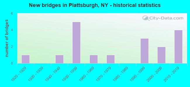
- New bridges - historical statistics
- 11920-1929
- 11940-1949
- 51950-1959
- 11960-1969
- 11970-1979
- 31990-1999
- 22000-2009
- 42010-2019
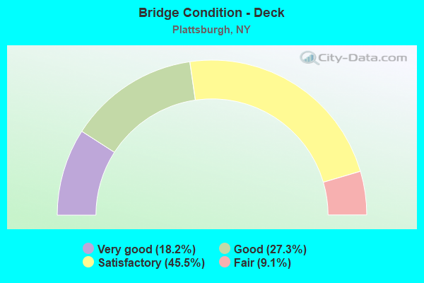
- Bridge Condition - Deck
- 18.2%Very good
- 27.3%Good
- 45.5%Satisfactory
- 9.1%Fair
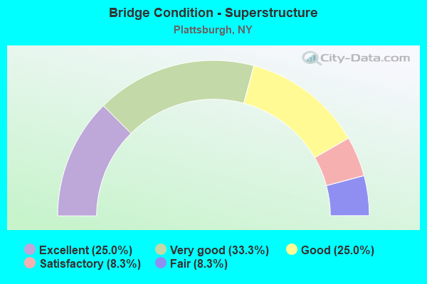
- Bridge Condition - Superstructure
- 25.0%Excellent
- 33.3%Very good
- 25.0%Good
- 8.3%Satisfactory
- 8.3%Fair
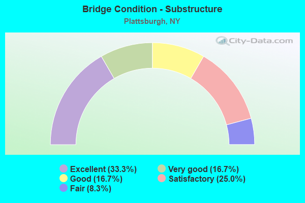
- Bridge Condition - Substructure
- 33.3%Excellent
- 16.7%Very good
- 16.7%Good
- 25.0%Satisfactory
- 8.3%Fair
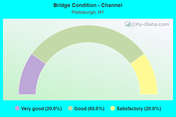
- Bridge Condition - Channel
- 20.0%Very good
- 60.0%Good
- 20.0%Satisfactory
Find on map >> Show street view
Structure Number: 1017299, Location: 1.6 MI NE JCT I87 & SH 3 (Lat: 44.714253, Lng: -73.464283), Route carried "on" structure: State highway 22, Year Built: 1996, Status: Open, Structure Length: 7.74m (25.39ft), Average Daily Traffic: 14,118 (year 2017), Truck Traffic: 6%, Average Future Daily Traffic: 17,150 (year 2040), Design Load: HS 25 or greater, Features Intersected: RTE I87, RTE I87
Minimum Vertical Clearance: 30+ m (98+ ft), Kilometerpoint: 28.672, Lanes on structure: 6, Lanes under structure: 6, Base Highway Network: Yes, Owner: State Highway Agency, Approaching Roadway Width: 29.3m (96.1ft), Skew: 21 degrees, Material/Design: Steel continuous, Design/Construction: Stringer/Multi-beam, Number Of Spans In Main Unit: 2, Length of Maximum Span: 38.7m (127.0ft), Curb-To-Curb Width: 29.3m (96.1ft), Out-to-Out Width: 33.5m (109.9ft)
Condition: Deck: Good, Superstructure: Good, Substructure: Very good, Operating Rating: 84.4 metric tons, Method Used To Determine Operating Rating: Load Factor (LF), Inventory Rating: 50.8 metric tons, Method Used To Determine Inventory Rating: Load Factor (LF), Structural Evaluation: Better than present minimum criteria, Deck Geometry: Superior to present desirable criteria, Underclear: Meets minimum limits, Approach Roadway Alignment: Equal to present desirable criteria, Length Of Structure Improvement: 7.74m (25.39ft), Designated Inspection Frequency: Every 24 months, Inspection Date: July 2020, Bridge Improvement Cost: $5,365,000, Roadway Improvement Cost: $3,142,000, Total Project Cost: $8,506,000 ( Estimate for 2021), Deck Structure Type: Concrete Cast-file-Place, Wearing Surface/Protective System: Wearing Surface: Integral Concrete, Deck Protection: Epoxy Coated Reinforcing
Find on map >> Show street view
Structure Number: 103401, Location: .4 MI South of I87-EXIT 3 (Lat: 44.706919, Lng: -73.477650), Route carried "on" structure: County highway , Year Built: 2010, Status: Open, Structure Length: 8.17m (26.80ft), Average Daily Traffic: 7,887 (year 2017), Truck Traffic: 2%, Average Future Daily Traffic: 9,581 (year 2040), Design Load: HL 93, Features Intersected: RTE I87, RTE I87, Facility Carried by Structure: TOM MILLER ROAD
Minimum Vertical Clearance: 30+ m (98+ ft), Kilometerpoint: 3.797, Lanes on structure: 2, Lanes under structure: 4, Owner: State Highway Agency, Approaching Roadway Width: 14.3m (46.9ft), Skew: 24 degrees, Material/Design: Steel continuous, Design/Construction: Stringer/Multi-beam, Number Of Spans In Main Unit: 2, Length of Maximum Span: 39.9m (130.9ft), Curb or Sidewalk Widths: Left: 1.7m (5.6ft), Right: 1.7m (5.6ft), Curb-To-Curb Width: 14.4m (47.2ft), Out-to-Out Width: 18.3m (60.0ft)
Condition: Deck: Good, Superstructure: Excellent, Substructure: Excellent, Operating Rating: 57.0 metric tons, Method Used To Determine Operating Rating: Load and Resistance Factor Rating (LRFR) rating reported by rating factor(RF) method using HL-93 loadings, Inventory Rating: 43.7 metric tons, Method Used To Determine Inventory Rating: Load and Resistance Factor Rating (LRFR) rating reported by rating factor(RF) method using HL-93 loadings, Structural Evaluation: Superior to present desirable criteria, Deck Geometry: Superior to present desirable criteria, Underclear: High priority of corrective action, Approach Roadway Alignment: Equal to present desirable criteria, Length Of Structure Improvement: 8.16m (26.77ft), Designated Inspection Frequency: Every 24 months, Inspection Date: July 2020, Bridge Improvement Cost: $3,186,000, Roadway Improvement Cost: $1,866,000, Total Project Cost: $5,052,000 ( Estimate for 2021), Deck Structure Type: Concrete Cast-file-Place, Wearing Surface/Protective System: Wearing Surface: Integral Concrete, Deck Protection: Epoxy Coated Reinforcing
Find on map >> Show street view
Structure Number: 1034021, Location: .5 MI NE I87 - EXIT 38 (Lat: 44.717239, Lng: -73.458692), Route carried "on" structure: Interstate 87, Year Built: 2011, Status: Open, Structure Length: 3.99m (13.09ft), Average Daily Traffic: 9,221 (year 2011), Truck Traffic: 15%, Design Load: HL 93, Features Intersected: CANADIAN PACIFIC RR
Minimum Vertical Clearance: 30+ m (98+ ft), Kilometerpoint: 27.015, Lanes on structure: 3, Base Highway Network: Yes, Owner: State Highway Agency, Approaching Roadway Width: 14.9m (48.9ft), Skew: 1 degrees, Material/Design: Steel, Design/Construction: Stringer/Multi-beam, Number Of Spans In Main Unit: 1, Length of Maximum Span: 39.0m (128.0ft), Curb-To-Curb Width: 15.0m (49.2ft), Out-to-Out Width: 15.9m (52.2ft)
Condition: Deck: Satisfactory, Superstructure: Excellent, Substructure: Excellent, Operating Rating: 61.7 metric tons, Method Used To Determine Operating Rating: Load Factor (LF), Inventory Rating: 36.3 metric tons, Method Used To Determine Inventory Rating: Load Factor (LF), Structural Evaluation: Superior to present desirable criteria, Deck Geometry: Meets minimum limits, Underclear: Superior to present desirable criteria, Approach Roadway Alignment: Equal to present desirable criteria, Length Of Structure Improvement: 3.99m (13.09ft), Designated Inspection Frequency: Every 24 months, Inspection Date: June 2021, Bridge Improvement Cost: $1,479,000, Roadway Improvement Cost: $866,000, Total Project Cost: $2,345,000 ( Estimate for 2021), Deck Structure Type: Concrete Cast-file-Place, Wearing Surface/Protective System: Wearing Surface: Integral Concrete, Deck Protection: Epoxy Coated Reinforcing
Find on map >> Show street view
Structure Number: 1034022, Location: .5 MI NE I87 - EXIT 38 (Lat: 44.717008, Lng: -73.458583), Route carried "on" structure: Interstate 87, Year Built: 2013, Status: Open, Structure Length: 3.99m (13.09ft), Average Daily Traffic: 7,460 (year 2017), Truck Traffic: 16%, Average Future Daily Traffic: 9,734 (year 2040), Design Load: HL 93, Features Intersected: CANADIAN PACIFIC RR
Minimum Vertical Clearance: 30+ m (98+ ft), Kilometerpoint: 27.015, Lanes on structure: 3, Base Highway Network: Yes, Owner: State Highway Agency, Approaching Roadway Width: 14.9m (48.9ft), Skew: 1 degrees, Material/Design: Steel, Design/Construction: Stringer/Multi-beam, Number Of Spans In Main Unit: 1, Length of Maximum Span: 39.0m (128.0ft), Curb-To-Curb Width: 15.0m (49.2ft), Out-to-Out Width: 15.9m (52.2ft)
Condition: Deck: Satisfactory, Superstructure: Excellent, Substructure: Excellent, Operating Rating: 61.7 metric tons, Method Used To Determine Operating Rating: Load Factor (LF), Inventory Rating: 36.3 metric tons, Method Used To Determine Inventory Rating: Load Factor (LF), Structural Evaluation: Superior to present desirable criteria, Deck Geometry: Meets minimum limits, Underclear: Better than present minimum criteria, Approach Roadway Alignment: Equal to present desirable criteria, Length Of Structure Improvement: 3.99m (13.09ft), Designated Inspection Frequency: Every 24 months, Inspection Date: June 2021, Bridge Improvement Cost: $1,548,000, Roadway Improvement Cost: $906,000, Total Project Cost: $2,454,000 ( Estimate for 2021), Deck Structure Type: Concrete Cast-file-Place, Wearing Surface/Protective System: Wearing Surface: Integral Concrete, Deck Protection: Epoxy Coated Reinforcing
Find on map >> Show street view
Structure Number: 103403, Location: BETWEEN EXITS 38 & 39-I87 (Lat: 44.721631, Lng: -73.450494), Route carried "on" structure: Interstate 87, Year Built: 1958, Status: Open, Structure Length: 1.22m (4.00ft), Average Daily Traffic: 14,919 (year 2017), Truck Traffic: 16%, Average Future Daily Traffic: 19,469 (year 2040), Design Load: HS 20, Features Intersected: DEAD CREEK
Minimum Vertical Clearance: 30+ m (98+ ft), Kilometerpoint: 27.852, Lanes on structure: 4, Base Highway Network: Yes, Owner: State Highway Agency, Approaching Roadway Width: 20.7m (67.9ft), Skew: 20 degrees, Material/Design: Concrete continuous, Design/Construction: Culvert, Number Of Spans In Main Unit: 2, Length of Maximum Span: 5.4m (17.7ft)
Condition: Channel: Good, Culverts: Satisfactory, Operating Rating: 88.9 metric tons, Method Used To Determine Operating Rating: Load Factor (LF), Inventory Rating: 53.5 metric tons, Method Used To Determine Inventory Rating: Load Factor (LF), Structural Evaluation: Equal to present minimum criteria, Waterway Adequacy: Equal to present minimum criteria, Approach Roadway Alignment: Equal to present desirable criteria, Length Of Structure Improvement: 1.21m (3.97ft), Designated Inspection Frequency: Every 24 months, Inspection Date: August 2021, Bridge Improvement Cost: $1,893,000, Roadway Improvement Cost: $1,109,000, Total Project Cost: $3,002,000 ( Estimate for 2021), Deck Structure Type: Concrete Cast-file-Place
Find on map >> Show street view
Structure Number: 1034041, Location: 3.7 MI N JCT RT I87 & 374 (Lat: 44.728944, Lng: -73.439906), Route carried "on" structure: State highway 314, Year Built: 1958, Year Reconstructed: 1993, Status: Open, Structure Length: 7.50m (24.61ft), Average Daily Traffic: 1,557 (year 2017), Truck Traffic: 7%, Average Future Daily Traffic: 1,564 (year 2040), Design Load: HS 20, Features Intersected: RTE I87, RTE I87
Minimum Vertical Clearance: 30+ m (98+ ft), Kilometerpoint: 0.483, Lanes on structure: 2, Lanes under structure: 5, Base Highway Network: Yes, Owner: State Highway Agency, Approaching Roadway Width: 11.0m (36.1ft), Skew: 2 degrees, Material/Design: Prestressed concrete continuous, Design/Construction: Box Beam or Girders - Multiple, Number Of Spans In Main Unit: 4, Length of Maximum Span: 23.4m (76.8ft), Curb-To-Curb Width: 9.8m (32.2ft), Out-to-Out Width: 10.7m (35.1ft)
Condition: Deck: Satisfactory, Superstructure: Very good, Substructure: Satisfactory, Operating Rating: 73.5 metric tons, Method Used To Determine Operating Rating: Load Factor (LF), Inventory Rating: 36.3 metric tons, Method Used To Determine Inventory Rating: Load Factor (LF), Structural Evaluation: Equal to present minimum criteria, Deck Geometry: Meets minimum limits, Underclear: High priority of corrective action, Approach Roadway Alignment: Equal to present desirable criteria, Length Of Structure Improvement: 7.49m (24.57ft), Designated Inspection Frequency: Every 24 months, Inspection Date: April 2020, Bridge Improvement Cost: $1,222,000, Roadway Improvement Cost: $716,000, Total Project Cost: $1,938,000 ( Estimate for 2021), Deck Structure Type: Concrete Cast-file-Place, Wearing Surface/Protective System: Wearing Surface: Integral Concrete
Find on map >> Show street view
Structure Number: 1034042, Location: 3.7MI N JCT I87 & RTE 374 (Lat: 44.728833, Lng: -73.440017), Route carried "on" structure: State highway 314, Year Built: 1958, Year Reconstructed: 1992, Status: Open, Structure Length: 7.50m (24.61ft), Average Daily Traffic: 1,557 (year 2017), Truck Traffic: 7%, Average Future Daily Traffic: 1,564 (year 2040), Design Load: HS 20+Mod, Features Intersected: RTE I87, RTE I87
Minimum Vertical Clearance: 30+ m (98+ ft), Kilometerpoint: 0.499, Lanes on structure: 2, Lanes under structure: 5, Base Highway Network: Yes, Owner: State Highway Agency, Approaching Roadway Width: 11.0m (36.1ft), Skew: 2 degrees, Material/Design: Prestressed concrete continuous, Design/Construction: Box Beam or Girders - Multiple, Number Of Spans In Main Unit: 4, Length of Maximum Span: 23.4m (76.8ft), Curb-To-Curb Width: 9.8m (32.2ft), Out-to-Out Width: 10.7m (35.1ft)
Condition: Deck: Satisfactory, Superstructure: Very good, Substructure: Satisfactory, Operating Rating: 73.5 metric tons, Method Used To Determine Operating Rating: Load Factor (LF), Inventory Rating: 36.3 metric tons, Method Used To Determine Inventory Rating: Load Factor (LF), Structural Evaluation: Equal to present minimum criteria, Deck Geometry: Meets minimum limits, Underclear: High priority of corrective action, Approach Roadway Alignment: Equal to present desirable criteria, Length Of Structure Improvement: 7.49m (24.57ft), Designated Inspection Frequency: Every 24 months, Inspection Date: April 2020, Bridge Improvement Cost: $1,222,000, Roadway Improvement Cost: $716,000, Total Project Cost: $1,938,000 ( Estimate for 2021), Deck Structure Type: Concrete Cast-file-Place, Wearing Surface/Protective System: Wearing Surface: Integral Concrete
Find on map >> Show street view
Structure Number: 221961, Location: CITY OF PLATTSBURGH (Lat: 44.717669, Lng: -73.442972), Route carried "on" structure: US 9, Year Built: 2005, Status: Open, Structure Length: 2.13m (6.99ft), Average Daily Traffic: 8,294 (year 2020), Truck Traffic: 3%, Average Future Daily Traffic: 8,332 (year 2040), Design Load: HS 25 or greater, Features Intersected: DEAD CREEK
Minimum Vertical Clearance: 30+ m (98+ ft), Kilometerpoint: 21.319, Lanes on structure: 2, Base Highway Network: Yes, Owner: City or Municipal Highway Agency, Approaching Roadway Width: 14.6m (47.9ft), Skew: 23 degrees, Material/Design: Prestressed concrete, Design/Construction: Box Beam or Girders - Multiple, Number Of Spans In Main Unit: 1, Length of Maximum Span: 20.0m (65.6ft), Curb or Sidewalk Widths: Left: 2.2m (7.2ft), Right: 2.2m (7.2ft), Curb-To-Curb Width: 14.6m (47.9ft), Out-to-Out Width: 20.1m (65.9ft)
Condition: Deck: Satisfactory, Superstructure: Good, Substructure: Excellent, Channel: Very good, Operating Rating: 97.2 metric tons, Method Used To Determine Operating Rating: Load and Resistance Factor Rating (LRFR) rating reported by rating factor(RF) method using HL-93 loadings, Inventory Rating: 86.5 metric tons, Method Used To Determine Inventory Rating: Load and Resistance Factor Rating (LRFR) rating reported by rating factor(RF) method using HL-93 loadings, Structural Evaluation: Better than present minimum criteria, Deck Geometry: Superior to present desirable criteria, Waterway Adequacy: Somewhat better than minimum adequacy, Approach Roadway Alignment: Equal to present desirable criteria, Length Of Structure Improvement: 2.13m (6.99ft), Designated Inspection Frequency: Every 24 months, Inspection Date: July 2021, Bridge Improvement Cost: $619,000, Roadway Improvement Cost: $362,000, Total Project Cost: $981,000 ( Estimate for 2021), Deck Structure Type: Concrete Cast-file-Place, Wearing Surface/Protective System: Wearing Surface: Integral Concrete, Deck Protection: Epoxy Coated Reinforcing
Find on map >> Show street view
Structure Number: 221962, Location: CITY OF PLATTSBURGH (Lat: 44.697556, Lng: -73.451056), Route carried "on" structure: US 9, Year Built: 1921, Status: Open, Structure Length: 5.06m (16.60ft), Average Daily Traffic: 6,132 (year 2020), Truck Traffic: 4%, Average Future Daily Traffic: 6,160 (year 2040), Features Intersected: SARANAC RIVER
Minimum Vertical Clearance: 30+ m (98+ ft), Kilometerpoint: 18.568, Lanes on structure: 2, Base Highway Network: Yes, Owner: City or Municipal Highway Agency, Approaching Roadway Width: 12.2m (40.0ft), Material/Design: Concrete, Design/Construction: Arch - Deck, Number Of Spans In Main Unit: 3, Length of Maximum Span: 15.5m (50.9ft), Curb or Sidewalk Widths: Left: 1.8m (5.9ft), Right: 1.8m (5.9ft), Curb-To-Curb Width: 12.2m (40.0ft), Out-to-Out Width: 17.1m (56.1ft)
Condition: Superstructure: Satisfactory, Substructure: Satisfactory, Channel: Satisfactory, Operating Rating: 38.2 metric tons, Method Used To Determine Operating Rating: Field evaluation and documented engineering judgment, Inventory Rating: 10.3 metric tons, Method Used To Determine Inventory Rating: Field evaluation and documented engineering judgment, Structural Evaluation: High priority of corrective action, Deck Geometry: Somewhat better than minimum adequacy, Waterway Adequacy: Somewhat better than minimum adequacy, Approach Roadway Alignment: Equal to present minimum criteria, Length Of Structure Improvement: 5.05m (16.57ft), Designated Inspection Frequency: Every 24 months, Inspection Date: September 2020, Bridge Improvement Cost: $4,435,000, Roadway Improvement Cost: $2,597,000, Total Project Cost: $7,032,000 ( Estimate for 2021), Wearing Surface/Protective System: Wearing Surface: Bituminous
Find on map >> Show street view
Structure Number: 221963, Location: BROAD ST OVER SARANAC RIV (Lat: 44.695450, Lng: -73.451111), Route carried "on" structure: City street , Year Built: 2001, Status: Open, Structure Length: 4.97m (16.31ft), Average Daily Traffic: 5,682 (year 2018), Truck Traffic: 5%, Average Future Daily Traffic: 5,708 (year 2040), Design Load: HS 25 or greater, Features Intersected: SARANAC RIVER, Facility Carried by Structure: BROAD STREET
Minimum Vertical Clearance: 30+ m (98+ ft), Kilometerpoint: 2.027, Lanes on structure: 2, Owner: City or Municipal Highway Agency, Approaching Roadway Width: 11.0m (36.1ft), Material/Design: Steel, Design/Construction: Stringer/Multi-beam, Number Of Spans In Main Unit: 1, Length of Maximum Span: 49.0m (160.8ft), Curb or Sidewalk Widths: Left: 1.7m (5.6ft), Right: 1.7m (5.6ft), Curb-To-Curb Width: 11.0m (36.1ft), Out-to-Out Width: 15.0m (49.2ft)
Condition: Deck: Very good, Superstructure: Very good, Substructure: Good, Channel: Good, Operating Rating: 89.8 metric tons, Method Used To Determine Operating Rating: Load Factor (LF), Inventory Rating: 54.4 metric tons, Method Used To Determine Inventory Rating: Load Factor (LF), Structural Evaluation: Better than present minimum criteria, Deck Geometry: Meets minimum limits, Waterway Adequacy: Equal to present minimum criteria, Approach Roadway Alignment: Equal to present desirable criteria, Length Of Structure Improvement: 4.96m (16.27ft), Designated Inspection Frequency: Every 24 months, Inspection Date: May 2021, Bridge Improvement Cost: $1,729,000, Roadway Improvement Cost: $1,013,000, Total Project Cost: $2,742,000 ( Estimate for 2021), Deck Structure Type: Concrete Cast-file-Place, Wearing Surface/Protective System: Wearing Surface: Integral Concrete, Deck Protection: Epoxy Coated Reinforcing
Find on map >> Show street view
Structure Number: 221965, Location: IN PLATTSBURGH (Lat: 44.687772, Lng: -73.458167), Route carried "on" structure: State highway 22, Year Built: 1994, Status: Open, Structure Length: 7.35m (24.11ft), Average Daily Traffic: 11,804 (year 2017), Truck Traffic: 4%, Average Future Daily Traffic: 14,339 (year 2040), Design Load: HS 25 or greater, Features Intersected: SARANAC RIVER
Minimum Vertical Clearance: 30+ m (98+ ft), Kilometerpoint: 25.261, Lanes on structure: 3, Base Highway Network: Yes, Owner: City or Municipal Highway Agency, Approaching Roadway Width: 11.6m (38.1ft), Skew: 1 degrees, Material/Design: Steel continuous, Design/Construction: Stringer/Multi-beam, Number Of Spans In Main Unit: 2, Length of Maximum Span: 36.5m (119.8ft), Curb or Sidewalk Widths: Left: 1.5m (4.9ft), Right: 1.5m (4.9ft), Curb-To-Curb Width: 11.6m (38.1ft), Out-to-Out Width: 15.2m (49.9ft)
Condition: Deck: Good, Superstructure: Good, Substructure: Very good, Channel: Good, Operating Rating: 78.9 metric tons, Method Used To Determine Operating Rating: Load Factor (LF), Inventory Rating: 47.2 metric tons, Method Used To Determine Inventory Rating: Load Factor (LF), Structural Evaluation: Better than present minimum criteria, Deck Geometry: High priority of replacement, Waterway Adequacy: Equal to present desirable criteria, Approach Roadway Alignment: Equal to present desirable criteria, Length Of Structure Improvement: 7.34m (24.08ft), Designated Inspection Frequency: Every 24 months, Inspection Date: August 2020, Bridge Improvement Cost: $2,556,000, Roadway Improvement Cost: $1,497,000, Total Project Cost: $4,053,000 ( Estimate for 2021), Deck Structure Type: Concrete Cast-file-Place, Wearing Surface/Protective System: Wearing Surface: Integral Concrete, Deck Protection: Epoxy Coated Reinforcing
Find on map >> Show street view
Structure Number: 221966, Location: IN PLATTSBURGH (Lat: 44.699842, Lng: -73.450575), Route carried "on" structure: Business City street , Year Built: 1979, Status: Open, Structure Length: 5.03m (16.50ft), Average Daily Traffic: 3,188 (year 2016), Truck Traffic: 2%, Average Future Daily Traffic: 3,944 (year 2040), Design Load: HS 20, Features Intersected: Access Road, DELAWARE &, Facility Carried by Structure: CUMBERLAND AVENUE
Minimum Vertical Clearance: 30+ m (98+ ft), Kilometerpoint: 0.080, Lanes on structure: 2, Owner: City or Municipal Highway Agency, Approaching Roadway Width: 9.1m (29.9ft), Material/Design: Prestressed concrete continuous, Design/Construction: Box Beam or Girders - Multiple, Number Of Spans In Main Unit: 4, Length of Maximum Span: 11.8m (38.7ft), Curb or Sidewalk Widths: Left: 1.5m (4.9ft), Right: 1.5m (4.9ft), Curb-To-Curb Width: 9.1m (29.9ft), Out-to-Out Width: 12.8m (42.0ft)
Condition: Deck: Fair, Superstructure: Fair, Substructure: Fair, Operating Rating: 57.2 metric tons, Method Used To Determine Operating Rating: Load Factor (LF), Inventory Rating: 27.2 metric tons, Method Used To Determine Inventory Rating: Load Factor (LF), Structural Evaluation: Somewhat better than minimum adequacy, Deck Geometry: Meets minimum limits, Underclear: Equal to present minimum criteria, Approach Roadway Alignment: Equal to present desirable criteria, Length Of Structure Improvement: 5.02m (16.47ft), Designated Inspection Frequency: Every 24 months, Inspection Date: October 2020, Bridge Improvement Cost: $1,094,000, Roadway Improvement Cost: $641,000, Total Project Cost: $1,735,000 ( Estimate for 2021), Deck Structure Type: Concrete Cast-file-Place, Wearing Surface/Protective System: Wearing Surface: Integral Concrete
Find on map >> Show street view
Structure Number: 22673, Location: 2MI E OF USRT9 & POST RD (Lat: 44.680758, Lng: -73.442528), Route carried "on" structure: Other road , Year Built: 1940, Year Reconstructed: 1993, Status: Open, Structure Length: 2.04m (6.69ft), Average Daily Traffic: 50 (year 2014), Truck Traffic: 10%, Average Future Daily Traffic: 70 (year 2034), Features Intersected: CANADIAN PACIFIC RR, Facility Carried by Structure: MARINA ACCESS RD
Minimum Vertical Clearance: 30+ m (98+ ft), Kilometerpoint: 0.000, Lanes on structure: 1, Owner: Railroad, Approaching Roadway Width: 3.7m (12.1ft), Material/Design: Steel, Design/Construction: Truss - Thru, Number Of Spans In Main Unit: 1, Length of Maximum Span: 19.8m (65.0ft), Curb-To-Curb Width: 3.7m (12.1ft), Out-to-Out Width: 4.2m (13.8ft)
Condition: Deck: Very good, Superstructure: Very good, Substructure: Good, Operating Rating: 58.3 metric tons, Method Used To Determine Operating Rating: Field evaluation and documented engineering judgment, Inventory Rating: 23.0 metric tons, Method Used To Determine Inventory Rating: Field evaluation and documented engineering judgment, Structural Evaluation: Equal to present minimum criteria, Deck Geometry: Meets minimum limits, Underclear: High priority of corrective action, Approach Roadway Alignment: High priority of corrective action, Length Of Structure Improvement: 2.04m (6.69ft), Designated Inspection Frequency: Every 24 months, Critical Feature Inspection Frequency: Every 24 months, Inspection Date: September 2021, Critical Feature Inspection Date: September 2021, Bridge Improvement Cost: $725,000, Roadway Improvement Cost: $424,000, Total Project Cost: $1,149,000 ( Estimate for 2021), Deck Structure Type: Steel plate, Wearing Surface/Protective System: Wearing Surface: Other
Find on map >> Show street view
Structure Number: 1017299, Location: 1.6 MI NE JCT I87 & SH 3 (Lat: 44.714253, Lng: -73.464283), Route carried "under" structure: Interstate 87, Year Built: 1996, Structure Length: 0. m, Average Daily Traffic: 10,300 (year 1978), Features Intersected: RTE I87, RTE I87, Facility Carried by Structure: RTE 22
Minimum Vertical Clearance: 5.13m (16.83ft), Kilometerpoint: 25.342, Lanes on structure: 6, Lanes under structure: 3, Material/Design: Steel continuous, Design/Construction: Stringer/Multi-beam, Length of Maximum Span: 38.7m (127.0ft)
Find on map >> Show street view
Structure Number: 103401, Location: .4 MI South of I87-EXIT 3 (Lat: 44.706919, Lng: -73.477650), Route carried "under" structure: Interstate 87, Year Built: 2010, Structure Length: 0. m, Average Daily Traffic: 1 (year 1971), Features Intersected: RTE I87, RTE I87, Facility Carried by Structure: TOM MILLER ROAD
Minimum Vertical Clearance: 5.41m (17.75ft), Kilometerpoint: 25.293, Lanes on structure: 2, Lanes under structure: 2, Material/Design: Steel continuous, Design/Construction: Stringer/Multi-beam, Length of Maximum Span: 39.9m (130.9ft)
Find on map >> Show street view
Structure Number: 1034041, Location: 3.7 MI N JCT RT I87 & 374 (Lat: 44.728944, Lng: -73.439906), Route carried "under" structure: Interstate 87, Year Built: 1958, Structure Length: 0. m, Average Daily Traffic: 17,500 (year 2000), Features Intersected: RTE I87, RTE I87, Facility Carried by Structure: RTE 314
Minimum Vertical Clearance: 5.44m (17.85ft), Kilometerpoint: 29.155, Lanes on structure: 2, Lanes under structure: 2, Material/Design: Prestressed concrete continuous, Design/Construction: Box Beam or Girders - Multiple, Length of Maximum Span: 23.4m (76.8ft)
Find on map >> Show street view
Structure Number: 1034042, Location: 3.7MI N JCT I87 & RTE 374 (Lat: 44.728833, Lng: -73.440017), Route carried "under" structure: Interstate 87, Year Built: 1958, Structure Length: 0. m, Average Daily Traffic: 17,500 (year 2000), Features Intersected: RTE I87, RTE I87, Facility Carried by Structure: RTE 314
Minimum Vertical Clearance: 5.36m (17.59ft), Kilometerpoint: 29.155, Lanes on structure: 2, Lanes under structure: 2, Material/Design: Prestressed concrete continuous, Design/Construction: Box Beam or Girders - Multiple, Length of Maximum Span: 23.4m (76.8ft)
Find on map >> Show street view
Structure Number: 336672, Location: CITY OF PLATTSBURGH (Lat: 44.695381, Lng: -73.467231), Route carried "under" structure: City street , Year Built: 1969, Structure Length: 0. m, Average Daily Traffic: 8,119 (year 2020), Truck Traffic: 2%, Features Intersected: BROAD STREET, Facility Carried by Structure: SUNY PEDESTRIAN
Minimum Vertical Clearance: 4.44m (14.57ft), Kilometerpoint: 0.274, Lanes under structure: 2, Material/Design: Steel, Design/Construction: Stringer/Multi-beam, Length of Maximum Span: 23.7m (77.8ft)