Bridge Statistics for Pleasant Gap, Pennsylvania (PA)
Condition, Traffic, Stress, Structural Evaluation, Project Costs
- National Bridge Inventory (NBI) Statistics
- 37Number of bridges
- 558ft / 170mTotal length
- $887,000Total costs
- 273,566Total average daily traffic
- 37,710Total average daily truck traffic
- National Bridge Inventory (NBI) Registered Bridges for Pleasant Gap
- No street view available for this location
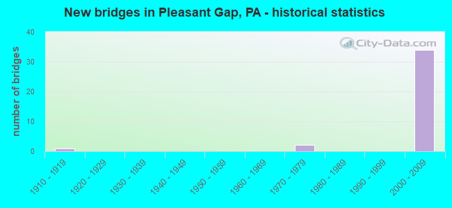
- New bridges - historical statistics
- 11910-1919
- 21970-1979
- 342000-2009

- Reconstructed bridges - Historical Statistics
- 11980-1989
- 01990-1999
- 12000-2009


- Bridge Condition - Deck
- 5.9%Very good
- 88.2%Good
- 5.9%Fair

- Bridge Condition - Superstructure
- 64.7%Very good
- 29.4%Good
- 5.9%Fair

- Bridge Condition - Substructure
- 82.4%Good
- 11.8%Satisfactory
- 5.9%Fair

- Bridge Condition - Channel
- 28.6%Excellent
- 28.6%Very good
- 14.3%Satisfactory
- 28.6%Fair
Find on map >> Show street view
Structure Number: 9217, Location: 5 MI SE BELLEFONTE (Lat: 40.885528, Lng: -77.725208), Route carried "on" structure: State highway 26, Year Built: 1973, Status: Open, Structure Length: 3.23m (10.60ft), Average Daily Traffic: 7,773 (year 2022), Truck Traffic: 10%, Average Future Daily Traffic: 3,659 (year 2040), Design Load: HS 20, Features Intersected: SEDA-COG/NIT&BALD EGL RR
Minimum Vertical Clearance: 30+ m (98+ ft), Kilometerpoint: 28.057, Lanes on structure: 2, Base Highway Network: Yes, Owner: State Highway Agency, Approaching Roadway Width: 11.0m (36.1ft), Skew: 1 degrees, Material/Design: Steel, Design/Construction: Stringer/Multi-beam, Number Of Spans In Main Unit: 1, Length of Maximum Span: 30.5m (100.1ft), Curb or Sidewalk Widths: Left: 0.2m (0.7ft), Right: 0.2m (0.7ft), Curb-To-Curb Width: 13.4m (44.0ft), Out-to-Out Width: 14.6m (47.9ft)
Condition: Deck: Good, Superstructure: Good, Substructure: Good, Operating Rating: 62.6 metric tons, Method Used To Determine Operating Rating: Allowable Stress (AS), Inventory Rating: 34.5 metric tons, Method Used To Determine Inventory Rating: Allowable Stress (AS), Structural Evaluation: Better than present minimum criteria, Deck Geometry: Equal to present minimum criteria, Underclear: High priority of corrective action, Approach Roadway Alignment: Equal to present desirable criteria, Length Of Structure Improvement: 3.20m (10.50ft), Designated Inspection Frequency: Every 24 months, Inspection Date: July 2020, Deck Structure Type: Concrete Cast-file-Place, Wearing Surface/Protective System: Wearing Surface: Monolithic Concrete
Find on map >> Show street view
Structure Number: 9345, Location: PLEASANT GAP (Lat: 40.858919, Lng: -77.730514), Route carried "on" structure: State highway 144, Year Built: 1918, Year Reconstructed: 1980, Status: Open, Structure Length: 0.67m (2.20ft), Average Daily Traffic: 5,955 (year 2020), Truck Traffic: 5%, Average Future Daily Traffic: 8,800 (year 2040), Design Load: H 15, Features Intersected: GAP RUN
Minimum Vertical Clearance: 30+ m (98+ ft), Kilometerpoint: 12.749, Lanes on structure: 2, Base Highway Network: Yes, Owner: State Highway Agency, Approaching Roadway Width: 9.4m (30.8ft), Skew: 3 degrees, Material/Design: Concrete, Design/Construction: Slab, Number Of Spans In Main Unit: 1, Length of Maximum Span: 6.1m (20.0ft), Curb-To-Curb Width: 9.5m (31.2ft), Out-to-Out Width: 10.2m (33.5ft)
Condition: Deck: Fair, Superstructure: Fair, Substructure: Fair, Channel: Fair, Operating Rating: 75.3 metric tons, Method Used To Determine Operating Rating: Field evaluation and documented engineering judgment, Inventory Rating: 45.4 metric tons, Method Used To Determine Inventory Rating: Field evaluation and documented engineering judgment, Structural Evaluation: Somewhat better than minimum adequacy, Deck Geometry: High priority of corrective action, Waterway Adequacy: Equal to present minimum criteria, Approach Roadway Alignment: Equal to present desirable criteria, Length Of Structure Improvement: 0.70m (2.30ft), Designated Inspection Frequency: Every 24 months, Inspection Date: June 2020, Bridge Improvement Cost: $23,000, Roadway Improvement Cost: $189,000, Total Project Cost: $312,000, Deck Structure Type: Concrete Cast-file-Place, Wearing Surface/Protective System: Wearing Surface: Bituminous, Membrane: Preformed Fabric
Find on map >> Show street view
Structure Number: 9795, Location: 0.75 MI W of PLEASANT GAP (Lat: 40.871589, Lng: -77.760314), Route carried "on" structure: ServiceCity street , Year Built: 1972, Year Reconstructed: 2014, Status: Open, Structure Length: 1.13m (3.71ft), Average Daily Traffic: 75 (year 2021), Truck Traffic: 1%, Average Future Daily Traffic: 94 (year 2043), Design Load: HS 20, Features Intersected: LOGAN BRANCH, Facility Carried by Structure: T-371 KROUT LANE
Minimum Vertical Clearance: 30+ m (98+ ft), Kilometerpoint: 0.000, Lanes on structure: 1, Owner: Town or Township Highway Agency, Approaching Roadway Width: 3.7m (12.1ft), Material/Design: Steel, Design/Construction: Stringer/Multi-beam, Number Of Spans In Main Unit: 1, Length of Maximum Span: 7.3m (24.0ft), Curb-To-Curb Width: 3.7m (12.1ft), Out-to-Out Width: 4.9m (16.1ft)
Condition: Deck: Very good, Superstructure: Very good, Substructure: Good, Channel: Fair, Operating Rating: 63.5 metric tons, Method Used To Determine Operating Rating: Load Factor (LF), Inventory Rating: 38.1 metric tons, Method Used To Determine Inventory Rating: Load Factor (LF), Structural Evaluation: Better than present minimum criteria, Deck Geometry: Meets minimum limits, Waterway Adequacy: Somewhat better than minimum adequacy, Approach Roadway Alignment: Equal to present desirable criteria, Length Of Structure Improvement: 1.10m (3.61ft), Designated Inspection Frequency: Every 24 months, Inspection Date: June 2021, Bridge Improvement Cost: $43,000, Roadway Improvement Cost: $243,000, Total Project Cost: $575,000, Deck Structure Type: Concrete Cast-file-Place, Wearing Surface/Protective System: Wearing Surface: Monolithic Concrete, Deck Protection: Epoxy Coated Reinforcing
Find on map >> Show street view
Structure Number: 40799, Location: 5 MI SE BELLEFONTE (Lat: 40.889944, Lng: -77.732956), Route carried "on" structure: Ramp State highway 26, Year Built: 2000, Status: Open, Structure Length: 11.89m (39.01ft), Average Daily Traffic: 1,797 (year 2020), Truck Traffic: 18%, Average Future Daily Traffic: 1,988 (year 2040), Design Load: HS 25 or greater, Features Intersected: SR 99-I 99
Minimum Vertical Clearance: 30+ m (98+ ft), Kilometerpoint: 28.498, Lanes on structure: 1, Lanes under structure: 8, Base Highway Network: Yes, Owner: State Highway Agency, Approaching Roadway Width: 8.8m (28.9ft), Skew: 4 degrees, Material/Design: Steel continuous, Design/Construction: Stringer/Multi-beam, Number Of Spans In Main Unit: 3, Length of Maximum Span: 41.8m (137.1ft), Curb or Sidewalk Widths: Left: 0.2m (0.7ft), Right: 0.2m (0.7ft), Curb-To-Curb Width: 9.4m (30.8ft), Out-to-Out Width: 10.3m (33.8ft)
Condition: Deck: Good, Superstructure: Good, Substructure: Good, Operating Rating: 81.6 metric tons, Method Used To Determine Operating Rating: Load Factor (LF), Inventory Rating: 49.0 metric tons, Method Used To Determine Inventory Rating: Load Factor (LF), Structural Evaluation: Better than present minimum criteria, Deck Geometry: Superior to present desirable criteria, Underclear: Better than present minimum criteria, Approach Roadway Alignment: Equal to present desirable criteria, Length Of Structure Improvement: 12.80m (41.99ft), Designated Inspection Frequency: Every 24 months, Inspection Date: July 2020, Deck Structure Type: Concrete Cast-file-Place, Wearing Surface/Protective System: Wearing Surface: Monolithic Concrete, Deck Protection: Epoxy Coated Reinforcing
Find on map >> Show street view
Structure Number: 41003, Location: 1 MI N PLEASANT GAP (Lat: 40.884433, Lng: -77.740317), Route carried "on" structure: State highway , Year Built: 2000, Status: Open, Structure Length: 6.46m (21.19ft), Average Daily Traffic: 3,166 (year 2022), Truck Traffic: 1%, Average Future Daily Traffic: 4,432 (year 2040), Design Load: HS 25 or greater, Features Intersected: SR 99-I 99, Facility Carried by Structure: ON TSR 430
Minimum Vertical Clearance: 30+ m (98+ ft), Kilometerpoint: 0.000, Lanes on structure: 2, Lanes under structure: 8, Owner: State Highway Agency, Approaching Roadway Width: 7.6m (24.9ft), Skew: 20 degrees, Material/Design: Prestressed concrete continuous, Design/Construction: Stringer/Multi-beam, Number Of Spans In Main Unit: 2, Length of Maximum Span: 32.0m (105.0ft), Curb or Sidewalk Widths: Left: 0.1m (0.3ft), Right: 0.1m (0.3ft), Curb-To-Curb Width: 16.2m (53.1ft), Out-to-Out Width: 17.0m (55.8ft)
Condition: Deck: Good, Superstructure: Good, Substructure: Good, Operating Rating: 96.2 metric tons, Method Used To Determine Operating Rating: Load Factor (LF), Inventory Rating: 47.2 metric tons, Method Used To Determine Inventory Rating: Load Factor (LF), Structural Evaluation: Better than present minimum criteria, Deck Geometry: Superior to present desirable criteria, Underclear: Better than present minimum criteria, Approach Roadway Alignment: Better than present minimum criteria, Length Of Structure Improvement: 7.40m (24.28ft), Designated Inspection Frequency: Every 24 months, Inspection Date: July 2020, Deck Structure Type: Concrete Cast-file-Place, Wearing Surface/Protective System: Wearing Surface: Monolithic Concrete, Deck Protection: Epoxy Coated Reinforcing
Find on map >> Show street view
Structure Number: 41162, Location: 3.8 MI E.OF STATE COLLEGE (Lat: 40.862117, Lng: -77.789000), Route carried "on" structure: Interstate 99, Year Built: 2001, Status: Open, Structure Length: 11.73m (38.48ft), Average Daily Traffic: 16,224 (year 2021), Truck Traffic: 13%, Average Future Daily Traffic: 17,236 (year 2041), Design Load: HS 25 or greater, Features Intersected: ROCKVIEW RD TR SPRING CR
Minimum Vertical Clearance: 30+ m (98+ ft), Kilometerpoint: 35.476, Lanes on structure: 2, Lanes under structure: 2, Base Highway Network: Yes, Owner: State Highway Agency, Approaching Roadway Width: 11.6m (38.1ft), Skew: 11 degrees, Material/Design: Prestressed concrete continuous, Design/Construction: Stringer/Multi-beam, Number Of Spans In Main Unit: 4, Length of Maximum Span: 29.0m (95.1ft), Curb or Sidewalk Widths: Left: 0.1m (0.3ft), Right: 0.1m (0.3ft), Curb-To-Curb Width: 12.2m (40.0ft), Out-to-Out Width: 13.1m (43.0ft)
Condition: Deck: Good, Superstructure: Very good, Substructure: Good, Channel: Excellent, Operating Rating: 98.0 metric tons, Method Used To Determine Operating Rating: Load Factor (LF), Inventory Rating: 48.1 metric tons, Method Used To Determine Inventory Rating: Load Factor (LF), Structural Evaluation: Better than present minimum criteria, Deck Geometry: Better than present minimum criteria, Underclear: Superior to present desirable criteria, Waterway Adequacy: Superior to present desirable criteria, Approach Roadway Alignment: Equal to present desirable criteria, Length Of Structure Improvement: 12.70m (41.67ft), Designated Inspection Frequency: Every 24 months, Inspection Date: April 2021, Deck Structure Type: Concrete Cast-file-Place, Wearing Surface/Protective System: Wearing Surface: Monolithic Concrete, Deck Protection: Epoxy Coated Reinforcing
Find on map >> Show street view
Structure Number: 41163, Location: 3.8 MI.E.OF STATE COLLEGE (Lat: 40.862228, Lng: -77.789294), Route carried "on" structure: Interstate 99, Year Built: 2001, Status: Open, Structure Length: 11.73m (38.48ft), Average Daily Traffic: 17,388 (year 2021), Truck Traffic: 13%, Average Future Daily Traffic: 18,538 (year 2041), Design Load: HS 25 or greater, Features Intersected: ROCKVIEW RD TR SPRING CR
Minimum Vertical Clearance: 30+ m (98+ ft), Kilometerpoint: 35.525, Lanes on structure: 2, Lanes under structure: 2, Base Highway Network: Yes, Owner: State Highway Agency, Approaching Roadway Width: 11.6m (38.1ft), Skew: 11 degrees, Material/Design: Prestressed concrete continuous, Design/Construction: Stringer/Multi-beam, Number Of Spans In Main Unit: 4, Length of Maximum Span: 29.0m (95.1ft), Curb or Sidewalk Widths: Left: 0.1m (0.3ft), Right: 0.1m (0.3ft), Curb-To-Curb Width: 12.2m (40.0ft), Out-to-Out Width: 13.1m (43.0ft)
Condition: Deck: Good, Superstructure: Very good, Substructure: Good, Channel: Excellent, Operating Rating: 97.1 metric tons, Method Used To Determine Operating Rating: Load Factor (LF), Inventory Rating: 48.1 metric tons, Method Used To Determine Inventory Rating: Load Factor (LF), Structural Evaluation: Better than present minimum criteria, Deck Geometry: Better than present minimum criteria, Underclear: Superior to present desirable criteria, Waterway Adequacy: Superior to present desirable criteria, Approach Roadway Alignment: Equal to present desirable criteria, Length Of Structure Improvement: 12.70m (41.67ft), Designated Inspection Frequency: Every 24 months, Inspection Date: April 2021, Deck Structure Type: Concrete Cast-file-Place, Wearing Surface/Protective System: Wearing Surface: Monolithic Concrete, Deck Protection: Epoxy Coated Reinforcing
Find on map >> Show street view
Structure Number: 41175, Location: 6 MI N. OF STATE COLLEGE (Lat: 40.872511, Lng: -77.778608), Route carried "on" structure: Interstate 99, Year Built: 2001, Status: Open, Structure Length: 7.47m (24.51ft), Average Daily Traffic: 11,304 (year 2021), Truck Traffic: 18%, Average Future Daily Traffic: 12,362 (year 2041), Design Load: HS 25 or greater, Features Intersected: SR 150-PA 150
Minimum Vertical Clearance: 30+ m (98+ ft), Kilometerpoint: 37.086, Lanes on structure: 3, Lanes under structure: 5, Base Highway Network: Yes, Owner: State Highway Agency, Approaching Roadway Width: 11.6m (38.1ft), Skew: 3 degrees, Material/Design: Steel, Design/Construction: Stringer/Multi-beam, Number Of Spans In Main Unit: 1, Length of Maximum Span: 73.2m (240.2ft), Curb or Sidewalk Widths: Left: 0.2m (0.7ft), Right: 0.2m (0.7ft), Curb-To-Curb Width: 15.9m (52.2ft), Out-to-Out Width: 16.8m (55.1ft)
Condition: Deck: Good, Superstructure: Very good, Substructure: Satisfactory, Operating Rating: 61.7 metric tons, Method Used To Determine Operating Rating: Load Factor (LF), Inventory Rating: 37.2 metric tons, Method Used To Determine Inventory Rating: Load Factor (LF), Structural Evaluation: Equal to present minimum criteria, Deck Geometry: Somewhat better than minimum adequacy, Underclear: Equal to present minimum criteria, Approach Roadway Alignment: Equal to present desirable criteria, Length Of Structure Improvement: 8.40m (27.56ft), Designated Inspection Frequency: Every 24 months, Inspection Date: April 2021, Deck Structure Type: Concrete Cast-file-Place, Wearing Surface/Protective System: Wearing Surface: Monolithic Concrete, Deck Protection: Epoxy Coated Reinforcing
Find on map >> Show street view
Structure Number: 41176, Location: 6 MI. N. STATE COLLEGE (Lat: 40.873008, Lng: -77.778469), Route carried "on" structure: Interstate 99, Year Built: 2001, Status: Open, Structure Length: 7.10m (23.29ft), Average Daily Traffic: 12,230 (year 2021), Truck Traffic: 17%, Average Future Daily Traffic: 13,086 (year 2041), Design Load: HS 25 or greater, Features Intersected: SR 150-PA 150
Minimum Vertical Clearance: 30+ m (98+ ft), Kilometerpoint: 37.136, Lanes on structure: 3, Lanes under structure: 5, Base Highway Network: Yes, Owner: State Highway Agency, Approaching Roadway Width: 15.2m (49.9ft), Skew: 3 degrees, Material/Design: Steel, Design/Construction: Stringer/Multi-beam, Number Of Spans In Main Unit: 1, Length of Maximum Span: 68.9m (226.0ft), Curb or Sidewalk Widths: Left: 0.2m (0.7ft), Right: 0.2m (0.7ft), Curb-To-Curb Width: 15.8m (51.8ft), Out-to-Out Width: 16.7m (54.8ft)
Condition: Deck: Good, Superstructure: Very good, Substructure: Satisfactory, Operating Rating: 53.5 metric tons, Method Used To Determine Operating Rating: Load Factor (LF), Inventory Rating: 31.8 metric tons, Method Used To Determine Inventory Rating: Load Factor (LF), Structural Evaluation: Equal to present minimum criteria, Deck Geometry: Somewhat better than minimum adequacy, Underclear: Equal to present minimum criteria, Approach Roadway Alignment: Equal to present desirable criteria, Length Of Structure Improvement: 8.00m (26.25ft), Designated Inspection Frequency: Every 24 months, Inspection Date: April 2021, Deck Structure Type: Concrete Cast-file-Place, Wearing Surface/Protective System: Wearing Surface: Monolithic Concrete, Deck Protection: Epoxy Coated Reinforcing
Find on map >> Show street view
Structure Number: 41327, Location: 30 FT WEST OF SR 144 (Lat: 40.889561, Lng: -77.760814), Route carried "on" structure: ServiceCity street 7221, Year Built: 2001, Status: Open, Structure Length: 1.04m (3.41ft), Average Daily Traffic: 30 (year 2021), Average Future Daily Traffic: 47 (year 2043), Design Load: HS 25 or greater, Features Intersected: LOGAN BRANCH, Facility Carried by Structure: T-423 MANN ROAD
Minimum Vertical Clearance: 30+ m (98+ ft), Kilometerpoint: 0.000, Lanes on structure: 2, Owner: Town or Township Highway Agency, Approaching Roadway Width: 7.3m (24.0ft), Material/Design: Concrete, Design/Construction: Culvert, Number Of Spans In Main Unit: 2, Length of Maximum Span: 4.6m (15.1ft), Curb or Sidewalk Widths: Left: 0.0m, Right: 1.5m (4.9ft), Curb-To-Curb Width: 6.7m (22.0ft), Out-to-Out Width: 9.0m (29.5ft)
Condition: Channel: Satisfactory, Culverts: Satisfactory, Operating Rating: 80.7 metric tons, Method Used To Determine Operating Rating: Load Factor (LF), Inventory Rating: 48.1 metric tons, Method Used To Determine Inventory Rating: Load Factor (LF), Structural Evaluation: Equal to present minimum criteria, Deck Geometry: Somewhat better than minimum adequacy, Waterway Adequacy: Equal to present desirable criteria, Approach Roadway Alignment: Equal to present desirable criteria, Length Of Structure Improvement: 1.20m (3.94ft), Designated Inspection Frequency: Every 24 months, Inspection Date: June 2021, Wearing Surface/Protective System: Wearing Surface: Bituminous, Membrane: Preformed Fabric, Deck Protection: Epoxy Coated Reinforcing
Find on map >> Show street view
Structure Number: 41663, Location: 1 MI S SR 150 INTERCHANGE (Lat: 40.866433, Lng: -77.784786), Route carried "on" structure: Interstate 99, Year Built: 2001, Status: Open, Structure Length: 3.78m (12.40ft), Average Daily Traffic: 16,224 (year 2021), Truck Traffic: 13%, Average Future Daily Traffic: 17,236 (year 2041), Design Load: HS 25 or greater, Features Intersected: PRISON ROAD D
Minimum Vertical Clearance: 30+ m (98+ ft), Kilometerpoint: 36.281, Lanes on structure: 2, Lanes under structure: 2, Base Highway Network: Yes, Owner: State Highway Agency, Approaching Roadway Width: 12.2m (40.0ft), Skew: 12 degrees, Material/Design: Prestressed concrete, Design/Construction: Stringer/Multi-beam, Number Of Spans In Main Unit: 1, Length of Maximum Span: 36.3m (119.1ft), Curb or Sidewalk Widths: Left: 0.1m (0.3ft), Right: 0.1m (0.3ft), Curb-To-Curb Width: 12.2m (40.0ft), Out-to-Out Width: 13.1m (43.0ft)
Condition: Deck: Good, Superstructure: Very good, Substructure: Good, Inventory Rating: 51.7 metric tons, Method Used To Determine Inventory Rating: Load Factor (LF), Structural Evaluation: Better than present minimum criteria, Deck Geometry: Better than present minimum criteria, Underclear: Somewhat better than minimum adequacy, Approach Roadway Alignment: Equal to present desirable criteria, Length Of Structure Improvement: 4.70m (15.42ft), Designated Inspection Frequency: Every 24 months, Inspection Date: April 2021, Deck Structure Type: Concrete Cast-file-Place, Wearing Surface/Protective System: Wearing Surface: Monolithic Concrete, Deck Protection: Epoxy Coated Reinforcing
Find on map >> Show street view
Structure Number: 41666, Location: 1 MI S SR 150 INTERCHANGE (Lat: 40.866542, Lng: -77.785122), Route carried "on" structure: Interstate 99, Year Built: 2001, Status: Open, Structure Length: 3.78m (12.40ft), Average Daily Traffic: 17,388 (year 2021), Truck Traffic: 13%, Average Future Daily Traffic: 18,538 (year 2041), Design Load: HS 25 or greater, Features Intersected: PRISON ROAD D
Minimum Vertical Clearance: 30+ m (98+ ft), Kilometerpoint: 36.326, Lanes on structure: 2, Lanes under structure: 2, Base Highway Network: Yes, Owner: State Highway Agency, Approaching Roadway Width: 11.6m (38.1ft), Skew: 12 degrees, Material/Design: Prestressed concrete, Design/Construction: Stringer/Multi-beam, Number Of Spans In Main Unit: 1, Length of Maximum Span: 36.3m (119.1ft), Curb or Sidewalk Widths: Left: 0.1m (0.3ft), Right: 0.1m (0.3ft), Curb-To-Curb Width: 13.2m (43.3ft), Out-to-Out Width: 14.1m (46.3ft)
Condition: Deck: Good, Superstructure: Very good, Substructure: Good, Inventory Rating: 51.7 metric tons, Method Used To Determine Inventory Rating: Load Factor (LF), Structural Evaluation: Better than present minimum criteria, Deck Geometry: Superior to present desirable criteria, Underclear: Somewhat better than minimum adequacy, Approach Roadway Alignment: Equal to present desirable criteria, Length Of Structure Improvement: 4.70m (15.42ft), Designated Inspection Frequency: Every 24 months, Inspection Date: April 2021, Deck Structure Type: Concrete Cast-file-Place, Wearing Surface/Protective System: Wearing Surface: Monolithic Concrete, Deck Protection: Epoxy Coated Reinforcing
Find on map >> Show street view
Structure Number: 41667, Location: 1/2 MI N SR 150 INTERCHAN (Lat: 40.875539, Lng: -77.773581), Route carried "on" structure: Interstate 99, Year Built: 2001, Status: Open, Structure Length: 2.87m (9.42ft), Average Daily Traffic: 11,304 (year 2021), Truck Traffic: 18%, Average Future Daily Traffic: 12,362 (year 2041), Design Load: HS 25 or greater, Features Intersected: PRISON ROAD E/VENTURE DR
Minimum Vertical Clearance: 30+ m (98+ ft), Kilometerpoint: 37.086, Lanes on structure: 3, Lanes under structure: 2, Base Highway Network: Yes, Owner: State Highway Agency, Approaching Roadway Width: 17.1m (56.1ft), Skew: 10 degrees, Material/Design: Prestressed concrete, Design/Construction: Stringer/Multi-beam, Number Of Spans In Main Unit: 1, Length of Maximum Span: 27.4m (89.9ft), Curb or Sidewalk Widths: Left: 0.1m (0.3ft), Right: 0.1m (0.3ft), Curb-To-Curb Width: 17.7m (58.1ft), Out-to-Out Width: 18.6m (61.0ft)
Condition: Deck: Good, Superstructure: Good, Substructure: Good, Operating Rating: 77.1 metric tons, Method Used To Determine Operating Rating: Load Factor (LF), Inventory Rating: 43.5 metric tons, Method Used To Determine Inventory Rating: Load Factor (LF), Structural Evaluation: Better than present minimum criteria, Deck Geometry: Better than present minimum criteria, Underclear: Meets minimum limits, Approach Roadway Alignment: Equal to present desirable criteria, Length Of Structure Improvement: 3.60m (11.81ft), Designated Inspection Frequency: Every 24 months, Inspection Date: April 2021, Deck Structure Type: Concrete Cast-file-Place, Wearing Surface/Protective System: Wearing Surface: Monolithic Concrete, Deck Protection: Epoxy Coated Reinforcing
Find on map >> Show street view
Structure Number: 41668, Location: 1/2 MI N SR 150 INTERCHAN (Lat: 40.875814, Lng: -77.773683), Route carried "on" structure: Interstate 99, Year Built: 2001, Status: Open, Structure Length: 2.87m (9.42ft), Average Daily Traffic: 12,230 (year 2021), Truck Traffic: 17%, Average Future Daily Traffic: 13,086 (year 2041), Design Load: HS 25 or greater, Features Intersected: PRISON ROAD E/VENTURE DR
Minimum Vertical Clearance: 30+ m (98+ ft), Kilometerpoint: 37.136, Lanes on structure: 3, Lanes under structure: 2, Base Highway Network: Yes, Owner: State Highway Agency, Approaching Roadway Width: 16.8m (55.1ft), Material/Design: Prestressed concrete, Design/Construction: Stringer/Multi-beam, Number Of Spans In Main Unit: 1, Length of Maximum Span: 27.4m (89.9ft), Curb or Sidewalk Widths: Left: 0.1m (0.3ft), Right: 0.1m (0.3ft), Curb-To-Curb Width: 17.6m (57.7ft), Out-to-Out Width: 18.5m (60.7ft)
Condition: Deck: Good, Superstructure: Good, Substructure: Good, Operating Rating: 78.0 metric tons, Method Used To Determine Operating Rating: Load Factor (LF), Inventory Rating: 47.2 metric tons, Method Used To Determine Inventory Rating: Load Factor (LF), Structural Evaluation: Better than present minimum criteria, Deck Geometry: Better than present minimum criteria, Underclear: Meets minimum limits, Approach Roadway Alignment: Equal to present desirable criteria, Length Of Structure Improvement: 3.60m (11.81ft), Designated Inspection Frequency: Every 24 months, Inspection Date: April 2021, Deck Structure Type: Concrete Cast-file-Place, Wearing Surface/Protective System: Wearing Surface: Monolithic Concrete, Deck Protection: Epoxy Coated Reinforcing
Find on map >> Show street view
Structure Number: 41681, Location: 2 MI NW PLEASANT GAP (Lat: 40.880706, Lng: -77.761272), Route carried "on" structure: Interstate 99, Year Built: 2001, Status: Open, Structure Length: 28.04m (91.99ft), Average Daily Traffic: 11,304 (year 2021), Truck Traffic: 18%, Average Future Daily Traffic: 12,362 (year 2041), Design Load: HS 25 or greater, Features Intersected: SR 144/SEDA-COG/NIT& B E
Minimum Vertical Clearance: 30+ m (98+ ft), Kilometerpoint: 38.695, Lanes on structure: 2, Lanes under structure: 2, Base Highway Network: Yes, Owner: State Highway Agency, Approaching Roadway Width: 11.6m (38.1ft), Skew: 11 degrees, Material/Design: Steel continuous, Design/Construction: Stringer/Multi-beam, Number Of Spans In Main Unit: 4, Length of Maximum Span: 74.7m (245.1ft), Curb or Sidewalk Widths: Left: 0.1m (0.3ft), Right: 0.1m (0.3ft), Curb-To-Curb Width: 12.2m (40.0ft), Out-to-Out Width: 13.0m (42.7ft)
Condition: Deck: Good, Superstructure: Very good, Substructure: Good, Channel: Very good, Operating Rating: 90.7 metric tons, Method Used To Determine Operating Rating: Load Factor (LF), Inventory Rating: 54.4 metric tons, Method Used To Determine Inventory Rating: Load Factor (LF), Structural Evaluation: Better than present minimum criteria, Deck Geometry: Better than present minimum criteria, Underclear: High priority of corrective action, Waterway Adequacy: Superior to present desirable criteria, Approach Roadway Alignment: Equal to present desirable criteria, Length Of Structure Improvement: 28.50m (93.50ft), Designated Inspection Frequency: Every 24 months, Inspection Date: July 2021, Deck Structure Type: Concrete Cast-file-Place, Wearing Surface/Protective System: Wearing Surface: Monolithic Concrete, Deck Protection: Epoxy Coated Reinforcing
Find on map >> Show street view
Structure Number: 41684, Location: 2 MILES N W PLEASANT GAP (Lat: 40.880947, Lng: -77.761261), Route carried "on" structure: Interstate 99, Year Built: 2001, Status: Open, Structure Length: 28.04m (91.99ft), Average Daily Traffic: 12,230 (year 2021), Truck Traffic: 17%, Average Future Daily Traffic: 13,086 (year 2041), Design Load: HS 25 or greater, Features Intersected: SR 144/SEDA-COG/NIT& B E
Minimum Vertical Clearance: 30+ m (98+ ft), Kilometerpoint: 38.761, Lanes on structure: 2, Lanes under structure: 2, Base Highway Network: Yes, Owner: State Highway Agency, Approaching Roadway Width: 11.6m (38.1ft), Skew: 1 degrees, Material/Design: Steel continuous, Design/Construction: Stringer/Multi-beam, Number Of Spans In Main Unit: 4, Length of Maximum Span: 74.7m (245.1ft), Curb or Sidewalk Widths: Left: 0.1m (0.3ft), Right: 0.1m (0.3ft), Curb-To-Curb Width: 12.2m (40.0ft), Out-to-Out Width: 13.0m (42.7ft)
Condition: Deck: Good, Superstructure: Very good, Substructure: Good, Channel: Very good, Operating Rating: 90.7 metric tons, Method Used To Determine Operating Rating: Load Factor (LF), Inventory Rating: 54.4 metric tons, Method Used To Determine Inventory Rating: Load Factor (LF), Structural Evaluation: Better than present minimum criteria, Deck Geometry: Better than present minimum criteria, Underclear: High priority of corrective action, Waterway Adequacy: Superior to present desirable criteria, Approach Roadway Alignment: Equal to present desirable criteria, Length Of Structure Improvement: 28.50m (93.50ft), Designated Inspection Frequency: Every 24 months, Inspection Date: July 2021, Deck Structure Type: Concrete Cast-file-Place, Wearing Surface/Protective System: Wearing Surface: Monolithic Concrete, Deck Protection: Epoxy Coated Reinforcing
Find on map >> Show street view
Structure Number: 41696, Location: 4 MI SE BELLEFONTE (Lat: 40.889067, Lng: -77.733267), Route carried "on" structure: Ramp State highway , Year Built: 2001, Status: Open, Structure Length: 34.96m (114.70ft), Average Daily Traffic: 1,496 (year 2021), Truck Traffic: 8%, Average Future Daily Traffic: 2,043 (year 2041), Design Load: HS 25 or greater, Features Intersected: SR 99 AND SR 8021, Facility Carried by Structure: SR 8021-PA 8021
Minimum Vertical Clearance: 30+ m (98+ ft), Kilometerpoint: 0.000, Lanes on structure: 1, Lanes under structure: 15, Base Highway Network: Yes, Owner: State Highway Agency, Approaching Roadway Width: 8.8m (28.9ft), Material/Design: Steel continuous, Design/Construction: Stringer/Multi-beam, Number Of Spans In Main Unit: 7, Length of Maximum Span: 56.4m (185.0ft), Curb or Sidewalk Widths: Left: 0.1m (0.3ft), Right: 0.1m (0.3ft), Curb-To-Curb Width: 9.4m (30.8ft), Out-to-Out Width: 10.3m (33.8ft)
Condition: Deck: Good, Superstructure: Very good, Substructure: Good, Operating Rating: 78.9 metric tons, Method Used To Determine Operating Rating: Load Factor (LF), Inventory Rating: 47.2 metric tons, Method Used To Determine Inventory Rating: Load Factor (LF), Structural Evaluation: Better than present minimum criteria, Deck Geometry: Superior to present desirable criteria, Underclear: High priority of corrective action, Approach Roadway Alignment: Equal to present desirable criteria, Length Of Structure Improvement: 32.40m (106.30ft), Designated Inspection Frequency: Every 24 months, Inspection Date: April 2021, Deck Structure Type: Concrete Cast-file-Place, Wearing Surface/Protective System: Wearing Surface: Monolithic Concrete, Deck Protection: Epoxy Coated Reinforcing
Find on map >> Show street view
Structure Number: 43342, Location: PLEASANT GAP (Lat: 40.876353, Lng: -77.730542), Route carried "on" structure: State highway 26, Year Built: 2006, Status: Open, Structure Length: 3.05m (10.01ft), Average Daily Traffic: 7,547 (year 2021), Truck Traffic: 10%, Average Future Daily Traffic: 8,974 (year 2040), Features Intersected: SEDA COG/NIT&BALD EGL RR
Minimum Vertical Clearance: 30+ m (98+ ft), Kilometerpoint: 25.901, Lanes on structure: 2, Base Highway Network: Yes, Owner: State Highway Agency, Approaching Roadway Width: 13.4m (44.0ft), Skew: 2 degrees, Material/Design: Prestressed concrete, Design/Construction: Box Beam or Girders - Single/Spread, Number Of Spans In Main Unit: 1, Length of Maximum Span: 29.9m (98.1ft), Curb-To-Curb Width: 13.4m (44.0ft), Out-to-Out Width: 14.3m (46.9ft)
Condition: Deck: Good, Superstructure: Very good, Substructure: Good, Operating Rating: 49.9 metric tons, Method Used To Determine Operating Rating: Load Factor (LF), Inventory Rating: 27.2 metric tons, Method Used To Determine Inventory Rating: Load Factor (LF), Structural Evaluation: Equal to present minimum criteria, Deck Geometry: Equal to present minimum criteria, Underclear: High priority of corrective action, Approach Roadway Alignment: Equal to present desirable criteria, Designated Inspection Frequency: Every 24 months, Inspection Date: June 2020, Deck Structure Type: Concrete Cast-file-Place, Wearing Surface/Protective System: Wearing Surface: Monolithic Concrete, Deck Protection: Epoxy Coated Reinforcing
Find on map >> Show street view
Structure Number: 40799, Location: 5 MI SE BELLEFONTE (Lat: 40.889944, Lng: -77.732956), Route carried "under" structure: Interstate 99, Year Built: 2000, Structure Length: 0. m, Average Daily Traffic: 11,304 (year 2021), Truck Traffic: 18%, Features Intersected: SR 99-I 99, Facility Carried by Structure: SR 26-PA 26 RAMP
Minimum Vertical Clearance: 5.83m (19.13ft), Kilometerpoint: 41.109, Lanes on structure: 1, Lanes under structure: 4, Material/Design: Steel continuous, Design/Construction: Stringer/Multi-beam, Length of Maximum Span: 41.8m (137.1ft)
Find on map >> Show street view
Structure Number: 40799, Location: 5 MI SE BELLEFONTE (Lat: 40.889944, Lng: -77.732956), Route carried "under" structure: Interstate 99, Year Built: 2000, Structure Length: 0. m, Average Daily Traffic: 9,837 (year 2021), Truck Traffic: 23%, Features Intersected: SR 99-I 99, Facility Carried by Structure: SR 26-PA 26 RAMP
Minimum Vertical Clearance: 6.89m (22.60ft), Kilometerpoint: 41.165, Lanes on structure: 1, Lanes under structure: 4, Material/Design: Steel continuous, Design/Construction: Stringer/Multi-beam, Length of Maximum Span: 41.8m (137.1ft)
Find on map >> Show street view
Structure Number: 41003, Location: 1 MI N PLEASANT GAP (Lat: 40.884433, Lng: -77.740317), Route carried "under" structure: Interstate 99, Year Built: 2000, Structure Length: 0. m, Average Daily Traffic: 11,304 (year 2021), Truck Traffic: 18%, Features Intersected: SR 99-I 99, Facility Carried by Structure: ON TSR 430
Minimum Vertical Clearance: 5.25m (17.22ft), Kilometerpoint: 40.304, Lanes on structure: 2, Lanes under structure: 4, Material/Design: Prestressed concrete continuous, Design/Construction: Stringer/Multi-beam, Length of Maximum Span: 32.0m (105.0ft)
Find on map >> Show street view
Structure Number: 41003, Location: 1 MI N PLEASANT GAP (Lat: 40.884433, Lng: -77.740317), Route carried "under" structure: Interstate 99, Year Built: 2000, Structure Length: 0. m, Average Daily Traffic: 12,230 (year 2021), Truck Traffic: 17%, Features Intersected: SR 99-I 99, Facility Carried by Structure: ON TSR 430
Minimum Vertical Clearance: 6.00m (19.69ft), Kilometerpoint: 40.372, Lanes on structure: 2, Lanes under structure: 4, Material/Design: Prestressed concrete continuous, Design/Construction: Stringer/Multi-beam, Length of Maximum Span: 32.0m (105.0ft)
Find on map >> Show street view
Structure Number: 41162, Location: 3.8 MI E.OF STATE COLLEGE (Lat: 40.862117, Lng: -77.789000), Route carried "under" structure: ServiceOther road , Year Built: 2001, Structure Length: 0. m, Features Intersected: ROCKVIEW RD TR SPRING CR, Facility Carried by Structure: SR 99-I 99
Minimum Vertical Clearance: 13.72m (45.01ft), Kilometerpoint: 0.000, Lanes on structure: 2, Lanes under structure: 2, Material/Design: Prestressed concrete continuous, Design/Construction: Stringer/Multi-beam, Length of Maximum Span: 29.0m (95.1ft)
Find on map >> Show street view
Structure Number: 41163, Location: 3.8 MI.E.OF STATE COLLEGE (Lat: 40.862228, Lng: -77.789294), Route carried "under" structure: ServiceOther road , Year Built: 2001, Structure Length: 0. m, Features Intersected: ROCKVIEW RD TR SPRING CR, Facility Carried by Structure: SR 99-I 99
Minimum Vertical Clearance: 14.23m (46.69ft), Kilometerpoint: 0.000, Lanes on structure: 2, Lanes under structure: 2, Material/Design: Prestressed concrete continuous, Design/Construction: Stringer/Multi-beam, Length of Maximum Span: 29.0m (95.1ft)
Find on map >> Show street view
Structure Number: 41175, Location: 6 MI N. OF STATE COLLEGE (Lat: 40.872511, Lng: -77.778608), Route carried "under" structure: State highway 150, Year Built: 2001, Structure Length: 0. m, Average Daily Traffic: 9,362 (year 2022), Truck Traffic: 3%, Features Intersected: SR 150-PA 150, Facility Carried by Structure: SR 99-I 99
Minimum Vertical Clearance: 5.09m (16.70ft), Kilometerpoint: 5.042, Lanes on structure: 3, Lanes under structure: 2, Material/Design: Steel, Design/Construction: Stringer/Multi-beam, Length of Maximum Span: 73.2m (240.2ft)
Find on map >> Show street view
Structure Number: 41175, Location: 6 MI N. OF STATE COLLEGE (Lat: 40.872511, Lng: -77.778608), Route carried "under" structure: State highway 150, Year Built: 2001, Structure Length: 0. m, Average Daily Traffic: 9,382 (year 2022), Truck Traffic: 3%, Features Intersected: SR 150-PA 150, Facility Carried by Structure: SR 99-I 99
Minimum Vertical Clearance: 5.11m (16.77ft), Kilometerpoint: 5.042, Lanes on structure: 3, Lanes under structure: 3, Material/Design: Steel, Design/Construction: Stringer/Multi-beam, Length of Maximum Span: 73.2m (240.2ft)
Find on map >> Show street view
Structure Number: 41176, Location: 6 MI. N. STATE COLLEGE (Lat: 40.873008, Lng: -77.778469), Route carried "under" structure: State highway 150, Year Built: 2001, Structure Length: 0. m, Average Daily Traffic: 9,362 (year 2022), Truck Traffic: 3%, Features Intersected: SR 150-PA 150, Facility Carried by Structure: SR 99-I 99
Minimum Vertical Clearance: 6.44m (21.13ft), Kilometerpoint: 5.042, Lanes on structure: 3, Lanes under structure: 2, Material/Design: Steel, Design/Construction: Stringer/Multi-beam, Length of Maximum Span: 68.9m (226.0ft)
Find on map >> Show street view
Structure Number: 41176, Location: 6 MI. N. STATE COLLEGE (Lat: 40.873008, Lng: -77.778469), Route carried "under" structure: State highway 150, Year Built: 2001, Structure Length: 0. m, Average Daily Traffic: 9,382 (year 2022), Truck Traffic: 3%, Features Intersected: SR 150-PA 150, Facility Carried by Structure: SR 99-I 99
Minimum Vertical Clearance: 6.55m (21.49ft), Kilometerpoint: 5.042, Lanes on structure: 3, Lanes under structure: 3, Material/Design: Steel, Design/Construction: Stringer/Multi-beam, Length of Maximum Span: 68.9m (226.0ft)
Find on map >> Show street view
Structure Number: 41663, Location: 1 MI S SR 150 INTERCHANGE (Lat: 40.866433, Lng: -77.784786), Route carried "under" structure: ServiceOther road , Year Built: 2001, Structure Length: 0. m, Average Daily Traffic: 50 (year 2003), Features Intersected: PRISON ROAD D, Facility Carried by Structure: SR 99-I 99
Minimum Vertical Clearance: 5.51m (18.08ft), Kilometerpoint: 0.000, Lanes on structure: 2, Lanes under structure: 2, Material/Design: Prestressed concrete, Design/Construction: Stringer/Multi-beam, Length of Maximum Span: 36.3m (119.1ft)
Find on map >> Show street view
Structure Number: 41666, Location: 1 MI S SR 150 INTERCHANGE (Lat: 40.866542, Lng: -77.785122), Route carried "under" structure: ServiceOther road , Year Built: 2001, Structure Length: 0. m, Average Daily Traffic: 50 (year 2003), Features Intersected: PRISON ROAD D, Facility Carried by Structure: SR 99-I 99
Minimum Vertical Clearance: 5.57m (18.27ft), Kilometerpoint: 0.000, Lanes on structure: 2, Lanes under structure: 2, Material/Design: Prestressed concrete, Design/Construction: Stringer/Multi-beam, Length of Maximum Span: 36.3m (119.1ft)
Find on map >> Show street view
Structure Number: 41667, Location: 1/2 MI N SR 150 INTERCHAN (Lat: 40.875539, Lng: -77.773581), Route carried "under" structure: ServiceOther road , Year Built: 2001, Structure Length: 0. m, Average Daily Traffic: 50 (year 2003), Features Intersected: PRISON ROAD E/VENTURE DR, Facility Carried by Structure: SR 99-I 99
Minimum Vertical Clearance: 5.57m (18.27ft), Kilometerpoint: 0.000, Lanes on structure: 3, Lanes under structure: 2, Material/Design: Prestressed concrete, Design/Construction: Stringer/Multi-beam, Length of Maximum Span: 27.4m (89.9ft)
Find on map >> Show street view
Structure Number: 41668, Location: 1/2 MI N SR 150 INTERCHAN (Lat: 40.875814, Lng: -77.773683), Route carried "under" structure: ServiceOther road , Year Built: 2001, Structure Length: 0. m, Average Daily Traffic: 50 (year 2003), Features Intersected: PRISON ROAD E/VENTURE DR, Facility Carried by Structure: SR 99-I 99
Minimum Vertical Clearance: 5.46m (17.91ft), Kilometerpoint: 0.000, Lanes on structure: 3, Lanes under structure: 2, Material/Design: Prestressed concrete, Design/Construction: Stringer/Multi-beam, Length of Maximum Span: 27.4m (89.9ft)
Find on map >> Show street view
Structure Number: 41681, Location: 2 MI NW PLEASANT GAP (Lat: 40.880706, Lng: -77.761272), Route carried "under" structure: State highway 144, Year Built: 2001, Structure Length: 0. m, Average Daily Traffic: 1,300 (year 2020), Truck Traffic: 7%, Features Intersected: SR 144/SEDA-COG/NIT& B E, Facility Carried by Structure: SR 99-I 99
Minimum Vertical Clearance: 28.27m (92.75ft), Kilometerpoint: 17.146, Lanes on structure: 2, Lanes under structure: 2, Material/Design: Steel continuous, Design/Construction: Stringer/Multi-beam, Length of Maximum Span: 74.7m (245.1ft)
Find on map >> Show street view
Structure Number: 41684, Location: 2 MILES N W PLEASANT GAP (Lat: 40.880947, Lng: -77.761261), Route carried "under" structure: State highway 144, Year Built: 2001, Structure Length: 0. m, Average Daily Traffic: 1,300 (year 2020), Truck Traffic: 7%, Features Intersected: SR 144/SEDA-COG/NIT& B E, Facility Carried by Structure: SR 99-I 99
Minimum Vertical Clearance: 30+ m (98+ ft), Kilometerpoint: 17.146, Lanes on structure: 2, Lanes under structure: 2, Material/Design: Steel continuous, Design/Construction: Stringer/Multi-beam, Length of Maximum Span: 74.7m (245.1ft)
Find on map >> Show street view
Structure Number: 41696, Location: 4 MI SE BELLEFONTE (Lat: 40.889067, Lng: -77.733267), Route carried "under" structure: Interstate 99, Year Built: 2001, Structure Length: 0. m, Average Daily Traffic: 9,837 (year 2021), Truck Traffic: 23%, Features Intersected: SR 99 AND SR 8021, Facility Carried by Structure: SR 8021-PA 8021
Minimum Vertical Clearance: 5.59m (18.34ft), Kilometerpoint: 41.165, Lanes on structure: 1, Lanes under structure: 5, Material/Design: Steel continuous, Design/Construction: Stringer/Multi-beam, Length of Maximum Span: 56.4m (185.0ft)
Find on map >> Show street view
Structure Number: 41696, Location: 4 MI SE BELLEFONTE (Lat: 40.889067, Lng: -77.733267), Route carried "under" structure: Ramp State highway 26, Year Built: 2001, Structure Length: 0. m, Average Daily Traffic: 1,797 (year 2020), Truck Traffic: 18%, Features Intersected: SR 99 AND SR 8021, Facility Carried by Structure: SR 8021-PA 8021
Minimum Vertical Clearance: 5.54m (18.18ft), Kilometerpoint: 28.498, Lanes on structure: 1, Lanes under structure: 5, Material/Design: Steel continuous, Design/Construction: Stringer/Multi-beam, Length of Maximum Span: 56.4m (185.0ft)
Find on map >> Show street view
Structure Number: 41696, Location: 4 MI SE BELLEFONTE (Lat: 40.889067, Lng: -77.733267), Route carried "under" structure: Interstate 99, Year Built: 2001, Structure Length: 0. m, Average Daily Traffic: 11,304 (year 2021), Truck Traffic: 18%, Features Intersected: SR 99 AND SR 8021, Facility Carried by Structure: SR 8021-PA 8021
Minimum Vertical Clearance: 7.03m (23.06ft), Kilometerpoint: 41.109, Lanes on structure: 1, Lanes under structure: 5, Material/Design: Steel continuous, Design/Construction: Stringer/Multi-beam, Length of Maximum Span: 56.4m (185.0ft)