Bridge Statistics for Pleasant Garden, North Carolina (NC)
Condition, Traffic, Stress, Structural Evaluation, Project Costs
- National Bridge Inventory (NBI) Statistics
- 42Number of bridges
- 341ft / 104mTotal length
- 264,920Total average daily traffic
- 40,622Total average daily truck traffic
- National Bridge Inventory (NBI) Registered Bridges for Pleasant Garden
- No street view available for this location
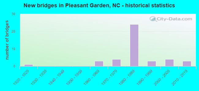
- New bridges - historical statistics
- 11920-1929
- 31960-1969
- 41970-1979
- 241980-1989
- 31990-1999
- 42000-2009
- 32010-2019


- Bridge Condition - Deck
- 9.5%Very good
- 23.8%Good
- 47.6%Satisfactory
- 19.0%Fair

- Bridge Condition - Superstructure
- 23.8%Very good
- 19.0%Good
- 33.3%Satisfactory
- 14.3%Fair
- 9.5%Poor

- Bridge Condition - Substructure
- 9.5%Very good
- 57.1%Good
- 14.3%Satisfactory
- 14.3%Fair
- 4.8%Poor

- Bridge Condition - Culverts
- 33.3%Good
- 66.7%Satisfactory
Find on map >> Show street view
Structure Number: 810004, Location: 1.4 MI. S. JCT. SR1104 (Lat: 35.922511, Lng: -79.825333), Route carried "on" structure: Interstate 73, Year Built: 1980, Status: Open, Structure Length: 5.63m (18.47ft), Average Daily Traffic: 12,500 (year 2018), Truck Traffic: 23%, Average Future Daily Traffic: 25,000 (year 2040), Design Load: HS 20+Mod, Features Intersected: NC62
Minimum Vertical Clearance: 30+ m (98+ ft), Kilometerpoint: 0.000, Lanes on structure: 2, Lanes under structure: 3, Base Highway Network: Yes (Inventory Route: 2, Subroute: 20), Owner: State Highway Agency, Approaching Roadway Width: 11.5m (37.7ft), Skew: 12 degrees, Material/Design: Steel, Design/Construction: Stringer/Multi-beam, Number Of Spans In Main Unit: 3, Number Of Approach Spans: 2, Length of Maximum Span: 33.5m (109.9ft), Curb-To-Curb Width: 11.9m (39.0ft), Out-to-Out Width: 13.0m (42.7ft)
Condition: Deck: Satisfactory, Superstructure: Satisfactory, Substructure: Good, Operating Rating: 81.6 metric tons, Method Used To Determine Operating Rating: Load Factor (LF), Inventory Rating: 48.9 metric tons, Method Used To Determine Inventory Rating: Load Factor (LF), Structural Evaluation: Equal to present minimum criteria, Deck Geometry: Equal to present minimum criteria, Underclear: Equal to present minimum criteria, Approach Roadway Alignment: Equal to present desirable criteria, Designated Inspection Frequency: Every 24 months, Inspection Date: Febuary 2022, Deck Structure Type: Concrete Cast-file-Place, Wearing Surface/Protective System: Wearing Surface: Monolithic Concrete
Find on map >> Show street view
Structure Number: 810005, Location: 1.4 MI. S. JCT. SR1104 (Lat: 35.922553, Lng: -79.825722), Route carried "on" structure: Interstate 73, Year Built: 1980, Status: Open, Structure Length: 5.82m (19.09ft), Average Daily Traffic: 12,500 (year 2018), Truck Traffic: 23%, Average Future Daily Traffic: 25,000 (year 2040), Design Load: HS 20+Mod, Features Intersected: NC62
Minimum Vertical Clearance: 30+ m (98+ ft), Kilometerpoint: 0.000, Lanes on structure: 2, Lanes under structure: 3, Base Highway Network: Yes (Inventory Route: 2, Subroute: 20), Owner: State Highway Agency, Approaching Roadway Width: 11.5m (37.7ft), Skew: 12 degrees, Material/Design: Steel, Design/Construction: Stringer/Multi-beam, Number Of Spans In Main Unit: 3, Number Of Approach Spans: 2, Length of Maximum Span: 33.5m (109.9ft), Curb-To-Curb Width: 12.1m (39.7ft), Out-to-Out Width: 13.0m (42.7ft)
Condition: Deck: Satisfactory, Superstructure: Satisfactory, Substructure: Good, Operating Rating: 80.7 metric tons, Method Used To Determine Operating Rating: Load Factor (LF), Inventory Rating: 48.0 metric tons, Method Used To Determine Inventory Rating: Load Factor (LF), Structural Evaluation: Equal to present minimum criteria, Deck Geometry: Equal to present minimum criteria, Underclear: Equal to present minimum criteria, Approach Roadway Alignment: Equal to present desirable criteria, Designated Inspection Frequency: Every 24 months, Inspection Date: Febuary 2022, Deck Structure Type: Concrete Cast-file-Place, Wearing Surface/Protective System: Wearing Surface: Monolithic Concrete
Find on map >> Show street view
Structure Number: 810006, Location: 1.3 MI. N. JCT. NC62 (Lat: 35.942669, Lng: -79.824997), Route carried "on" structure: Interstate 73, Year Built: 1980, Status: Open, Structure Length: 6.82m (22.38ft), Average Daily Traffic: 14,750 (year 2018), Truck Traffic: 23%, Average Future Daily Traffic: 29,500 (year 2040), Design Load: HS 20+Mod, Features Intersected: SR1104
Minimum Vertical Clearance: 30+ m (98+ ft), Kilometerpoint: 0.000, Lanes on structure: 2, Lanes under structure: 2, Base Highway Network: Yes (Inventory Route: 2, Subroute: 20), Owner: State Highway Agency, Approaching Roadway Width: 11.5m (37.7ft), Skew: 14 degrees, Material/Design: Steel, Design/Construction: Stringer/Multi-beam, Number Of Spans In Main Unit: 3, Length of Maximum Span: 37.7m (123.7ft), Curb-To-Curb Width: 11.9m (39.0ft), Out-to-Out Width: 13.0m (42.7ft)
Condition: Deck: Satisfactory, Superstructure: Satisfactory, Substructure: Good, Operating Rating: 83.4 metric tons, Method Used To Determine Operating Rating: Load Factor (LF), Inventory Rating: 49.8 metric tons, Method Used To Determine Inventory Rating: Load Factor (LF), Structural Evaluation: Equal to present minimum criteria, Deck Geometry: Equal to present minimum criteria, Underclear: Superior to present desirable criteria, Approach Roadway Alignment: Equal to present desirable criteria, Designated Inspection Frequency: Every 24 months, Inspection Date: Febuary 2022, Deck Structure Type: Concrete Cast-file-Place, Wearing Surface/Protective System: Wearing Surface: Monolithic Concrete
Find on map >> Show street view
Structure Number: 810007, Location: 1.3 MI. N. JCT. NC62 (Lat: 35.943000, Lng: -79.825181), Route carried "on" structure: Interstate 73, Year Built: 1980, Status: Open, Structure Length: 7.01m (23.00ft), Average Daily Traffic: 14,750 (year 2018), Truck Traffic: 23%, Average Future Daily Traffic: 29,500 (year 2040), Design Load: HS 20+Mod, Features Intersected: SR1104
Minimum Vertical Clearance: 30+ m (98+ ft), Kilometerpoint: 27.737, Lanes on structure: 2, Lanes under structure: 2, Base Highway Network: Yes (Inventory Route: 2, Subroute: 20), Owner: State Highway Agency, Approaching Roadway Width: 11.2m (36.7ft), Skew: 14 degrees, Material/Design: Steel, Design/Construction: Stringer/Multi-beam, Number Of Spans In Main Unit: 3, Length of Maximum Span: 37.7m (123.7ft), Curb-To-Curb Width: 12.1m (39.7ft), Out-to-Out Width: 13.0m (42.7ft)
Condition: Deck: Satisfactory, Superstructure: Satisfactory, Substructure: Good, Operating Rating: 84.3 metric tons, Method Used To Determine Operating Rating: Load Factor (LF), Inventory Rating: 49.8 metric tons, Method Used To Determine Inventory Rating: Load Factor (LF), Structural Evaluation: Equal to present minimum criteria, Deck Geometry: Equal to present minimum criteria, Underclear: Superior to present desirable criteria, Approach Roadway Alignment: Equal to present desirable criteria, Designated Inspection Frequency: Every 24 months, Inspection Date: Febuary 2022, Deck Structure Type: Concrete Cast-file-Place, Wearing Surface/Protective System: Wearing Surface: Monolithic Concrete
Find on map >> Show street view
Structure Number: 810009, Location: 0.5 MI. S. JCT. SR3393 (Lat: 35.941075, Lng: -79.690394), Route carried "on" structure: State highway 3392, Year Built: 1994, Status: Open, Structure Length: 1.43m (4.69ft), Average Daily Traffic: 100 (year 2013), Truck Traffic: 6%, Average Future Daily Traffic: 200 (year 2025), Design Load: HS 20+Mod, Features Intersected: PRONG ALAMANCE CREEK
Minimum Vertical Clearance: 30+ m (98+ ft), Kilometerpoint: 0.000, Lanes on structure: 2, Owner: State Highway Agency, Approaching Roadway Width: 7.3m (24.0ft), Material/Design: Prestressed concrete, Design/Construction: Slab, Number Of Spans In Main Unit: 1, Length of Maximum Span: 13.4m (44.0ft), Curb-To-Curb Width: 7.3m (24.0ft), Out-to-Out Width: 8.2m (26.9ft)
Condition: Deck: Good, Superstructure: Good, Substructure: Good, Channel: Good, Operating Rating: 89.8 metric tons, Method Used To Determine Operating Rating: Load Factor (LF), Inventory Rating: 57.1 metric tons, Method Used To Determine Inventory Rating: Load Factor (LF), Structural Evaluation: Better than present minimum criteria, Deck Geometry: Equal to present minimum criteria, Waterway Adequacy: Better than present minimum criteria, Approach Roadway Alignment: Equal to present desirable criteria, Designated Inspection Frequency: Every 24 months, Inspection Date: August 2020, Deck Structure Type: Concrete Precast Panels, Wearing Surface/Protective System: Wearing Surface: Bituminous
Find on map >> Show street view
Structure Number: 81001, Location: 0.45 MI. N. JCT. SR3397 (Lat: 35.940458, Lng: -79.700081), Route carried "on" structure: State highway 3394, Year Built: 1963, Status: Posted for load, Structure Length: 0.94m (3.08ft), Average Daily Traffic: 3,200 (year 2019), Truck Traffic: 7%, Average Future Daily Traffic: 6,400 (year 2040), Features Intersected: BRANCH OF BIG ALAMANCE C
Minimum Vertical Clearance: 30+ m (98+ ft), Kilometerpoint: 0.000, Lanes on structure: 2, Owner: State Highway Agency, Approaching Roadway Width: 6.7m (22.0ft), Material/Design: Prestressed concrete, Design/Construction: Channel Beam, Number Of Spans In Main Unit: 1, Length of Maximum Span: 8.8m (28.9ft), Curb or Sidewalk Widths: Left: 0.1m (0.3ft), Right: 0.1m (0.3ft), Curb-To-Curb Width: 7.3m (24.0ft), Out-to-Out Width: 7.7m (25.3ft)
Condition: Deck: Fair, Superstructure: Fair, Substructure: Satisfactory, Channel: Good, Operating Rating: 43.5 metric tons, Method Used To Determine Operating Rating: Load Factor (LF), Inventory Rating: 23.5 metric tons, Method Used To Determine Inventory Rating: Load Factor (LF), Structural Evaluation: Somewhat better than minimum adequacy, Deck Geometry: High priority of replacement, Waterway Adequacy: Better than present minimum criteria, Approach Roadway Alignment: Equal to present desirable criteria, Bridge Posting: Required (Relationship of Operating Rating to Maximum Legal Load: 0.1 - 9.9% below), Designated Inspection Frequency: Every 24 months, Inspection Date: September 2020, Deck Structure Type: Concrete Cast-file-Place, Wearing Surface/Protective System: Wearing Surface: Bituminous
Find on map >> Show street view
Structure Number: 810011, Location: 0.4 MI. S. JCT. US421 (Lat: 35.955036, Lng: -79.700589), Route carried "on" structure: State highway 3394, Year Built: 2009, Status: Open, Structure Length: 3.35m (10.99ft), Average Daily Traffic: 3,500 (year 2019), Truck Traffic: 7%, Average Future Daily Traffic: 7,000 (year 2025), Design Load: HS 25 or greater, Features Intersected: LITTLE ALAMANCE CREEK
Minimum Vertical Clearance: 30+ m (98+ ft), Kilometerpoint: 0.000, Lanes on structure: 2, Owner: State Highway Agency, Approaching Roadway Width: 8.5m (27.9ft), Material/Design: Steel, Design/Construction: Stringer/Multi-beam, Number Of Spans In Main Unit: 1, Length of Maximum Span: 32.3m (106.0ft), Curb-To-Curb Width: 9.9m (32.5ft), Out-to-Out Width: 11.0m (36.1ft)
Condition: Deck: Good, Superstructure: Very good, Substructure: Very good, Channel: Good, Operating Rating: 89.8 metric tons, Method Used To Determine Operating Rating: Load Factor (LF), Inventory Rating: 58.0 metric tons, Method Used To Determine Inventory Rating: Load Factor (LF), Structural Evaluation: Equal to present desirable criteria, Deck Geometry: Meets minimum limits, Waterway Adequacy: Better than present minimum criteria, Approach Roadway Alignment: Equal to present desirable criteria, Designated Inspection Frequency: Every 24 months, Inspection Date: July 2021, Deck Structure Type: Concrete Cast-file-Place, Wearing Surface/Protective System: Wearing Surface: Monolithic Concrete, Deck Protection: Epoxy Coated Reinforcing
Find on map >> Show street view
Structure Number: 810016, Location: 0.35 MI. S. JCT. SR3412 (Lat: 35.957983, Lng: -79.713036), Route carried "on" structure: State highway 3411, Year Built: 1982, Status: Open, Structure Length: 2.80m (9.19ft), Average Daily Traffic: 530 (year 2015), Truck Traffic: 6%, Average Future Daily Traffic: 1,060 (year 2025), Design Load: HS 20+Mod, Features Intersected: BIG ALAMANCE CREEK
Minimum Vertical Clearance: 30+ m (98+ ft), Kilometerpoint: 0.000, Lanes on structure: 2, Owner: State Highway Agency, Approaching Roadway Width: 6.7m (22.0ft), Material/Design: Prestressed concrete, Design/Construction: Slab, Number Of Spans In Main Unit: 3, Length of Maximum Span: 8.8m (28.9ft), Curb-To-Curb Width: 7.6m (24.9ft), Out-to-Out Width: 8.3m (27.2ft)
Condition: Deck: Satisfactory, Superstructure: Satisfactory, Substructure: Good, Channel: Good, Operating Rating: 89.8 metric tons, Method Used To Determine Operating Rating: Load Factor (LF), Inventory Rating: 60.7 metric tons, Method Used To Determine Inventory Rating: Load Factor (LF), Structural Evaluation: Equal to present minimum criteria, Deck Geometry: Meets minimum limits, Waterway Adequacy: Better than present minimum criteria, Approach Roadway Alignment: Equal to present desirable criteria, Designated Inspection Frequency: Every 24 months, Inspection Date: August 2020, Deck Structure Type: Concrete Precast Panels, Wearing Surface/Protective System: Wearing Surface: Bituminous
Find on map >> Show street view
Structure Number: 810023, Location: 0.35 MI.N.JCT.NC62 (Lat: 35.924603, Lng: -79.797356), Route carried "on" structure: State highway 3433, Year Built: 2008, Status: Open, Structure Length: 3.10m (10.17ft), Average Daily Traffic: 990 (year 2017), Truck Traffic: 6%, Average Future Daily Traffic: 1,980 (year 2040), Design Load: HS 20+Mod, Features Intersected: POLE CAT CREEK
Minimum Vertical Clearance: 30+ m (98+ ft), Kilometerpoint: 0.000, Lanes on structure: 2, Owner: State Highway Agency, Approaching Roadway Width: 9.1m (29.9ft), Skew: 1 degrees, Material/Design: Prestressed concrete, Design/Construction: Slab, Number Of Spans In Main Unit: 3, Length of Maximum Span: 14.6m (47.9ft), Curb-To-Curb Width: 9.1m (29.9ft), Out-to-Out Width: 10.0m (32.8ft)
Condition: Deck: Very good, Superstructure: Very good, Substructure: Very good, Channel: Good, Operating Rating: 78.0 metric tons, Method Used To Determine Operating Rating: Load Factor (LF), Inventory Rating: 46.2 metric tons, Method Used To Determine Inventory Rating: Load Factor (LF), Structural Evaluation: Equal to present desirable criteria, Deck Geometry: Equal to present minimum criteria, Waterway Adequacy: Better than present minimum criteria, Approach Roadway Alignment: Equal to present desirable criteria, Designated Inspection Frequency: Every 24 months, Inspection Date: June 2020, Deck Structure Type: Concrete Precast Panels, Wearing Surface/Protective System: Wearing Surface: Bituminous
Find on map >> Show street view
Structure Number: 810025, Location: 0.05 MI.E JCT.SR1007 (Lat: 35.953492, Lng: -79.811706), Route carried "on" structure: State highway 1105, Year Built: 1975, Status: Posted for load, Structure Length: 2.16m (7.09ft), Average Daily Traffic: 800 (year 2019), Truck Traffic: 7%, Average Future Daily Traffic: 1,600 (year 2040), Features Intersected: POLECAT CREEK
Minimum Vertical Clearance: 30+ m (98+ ft), Kilometerpoint: 0.000, Lanes on structure: 2, Owner: State Highway Agency, Approaching Roadway Width: 5.7m (18.7ft), Skew: 1 degrees, Material/Design: Steel, Design/Construction: Stringer/Multi-beam, Number Of Spans In Main Unit: 2, Length of Maximum Span: 10.3m (33.8ft), Curb-To-Curb Width: 7.3m (24.0ft), Out-to-Out Width: 7.3m (24.0ft)
Condition: Deck: Satisfactory, Superstructure: Poor, Substructure: Poor, Channel: Good, Operating Rating: 29.9 metric tons, Method Used To Determine Operating Rating: Load Factor (LF), Inventory Rating: 18.1 metric tons, Method Used To Determine Inventory Rating: Load Factor (LF), Structural Evaluation: Meets minimum limits, Deck Geometry: Meets minimum limits, Waterway Adequacy: Equal to present minimum criteria, Approach Roadway Alignment: Better than present minimum criteria, Bridge Posting: Required (Relationship of Operating Rating to Maximum Legal Load: 20.0 - 29.9% below), Designated Inspection Frequency: Every 24 months, Inspection Date: September 2020, Deck Structure Type: Corrugated Steel, Wearing Surface/Protective System: Wearing Surface: Bituminous
Find on map >> Show street view
Structure Number: 810072, Location: 0.2 MI. N. JCT. SR3433 (Lat: 35.919586, Lng: -79.796250), Route carried "on" structure: State highway 62, Year Built: 2008, Status: Open, Structure Length: 4.02m (13.19ft), Average Daily Traffic: 6,000 (year 2019), Truck Traffic: 8%, Average Future Daily Traffic: 12,000 (year 2040), Design Load: HS 20+Mod, Features Intersected: POLECAT CREEK
Minimum Vertical Clearance: 30+ m (98+ ft), Kilometerpoint: 0.000, Lanes on structure: 2, Owner: State Highway Agency, Approaching Roadway Width: 8.5m (27.9ft), Material/Design: Prestressed concrete, Design/Construction: Slab, Number Of Spans In Main Unit: 3, Length of Maximum Span: 17.6m (57.7ft), Curb-To-Curb Width: 10.0m (32.8ft), Out-to-Out Width: 10.9m (35.8ft)
Condition: Deck: Very good, Superstructure: Very good, Substructure: Good, Channel: Good, Operating Rating: 74.3 metric tons, Method Used To Determine Operating Rating: Load Factor (LF), Inventory Rating: 44.4 metric tons, Method Used To Determine Inventory Rating: Load Factor (LF), Structural Evaluation: Better than present minimum criteria, Deck Geometry: Meets minimum limits, Waterway Adequacy: Better than present minimum criteria, Approach Roadway Alignment: Equal to present desirable criteria, Designated Inspection Frequency: Every 24 months, Inspection Date: December 2021, Deck Structure Type: Concrete Precast Panels, Wearing Surface/Protective System: Wearing Surface: Bituminous
Find on map >> Show street view
Structure Number: 81009, Location: 0.8 MI. E. JCT. SR3380 (Lat: 35.914414, Lng: -79.674639), Route carried "on" structure: State highway 62, Year Built: 1973, Status: Open, Structure Length: 9.54m (31.30ft), Average Daily Traffic: 3,800 (year 2017), Truck Traffic: 8%, Average Future Daily Traffic: 7,600 (year 2040), Design Load: HS 20+Mod, Features Intersected: US421
Minimum Vertical Clearance: 30+ m (98+ ft), Kilometerpoint: 57.845, Lanes on structure: 2, Lanes under structure: 6, Owner: State Highway Agency, Approaching Roadway Width: 9.4m (30.8ft), Skew: 2 degrees, Material/Design: Steel, Design/Construction: Stringer/Multi-beam, Number Of Spans In Main Unit: 5, Length of Maximum Span: 28.6m (93.8ft), Curb-To-Curb Width: 12.1m (39.7ft), Out-to-Out Width: 12.8m (42.0ft)
Condition: Deck: Good, Superstructure: Satisfactory, Substructure: Fair, Operating Rating: 59.8 metric tons, Method Used To Determine Operating Rating: Load Factor (LF), Inventory Rating: 36.2 metric tons, Method Used To Determine Inventory Rating: Load Factor (LF), Structural Evaluation: Somewhat better than minimum adequacy, Deck Geometry: Somewhat better than minimum adequacy, Underclear: Equal to present minimum criteria, Approach Roadway Alignment: Equal to present desirable criteria, Designated Inspection Frequency: Every 24 months, Inspection Date: January 2022, Deck Structure Type: Concrete Cast-file-Place, Wearing Surface/Protective System: Wearing Surface: Monolithic Concrete
Find on map >> Show street view
Structure Number: 810531, Location: 1.0 MI. S. JCT. I85 (Lat: 35.966617, Lng: -79.820672), Route carried "on" structure: Interstate 73, Year Built: 1980, Status: Open, Structure Length: 4.02m (13.19ft), Average Daily Traffic: 14,750 (year 2018), Truck Traffic: 16%, Average Future Daily Traffic: 29,500 (year 2040), Design Load: HS 20+Mod, Features Intersected: SR1106
Minimum Vertical Clearance: 30+ m (98+ ft), Kilometerpoint: 0.000, Lanes on structure: 2, Lanes under structure: 2, Base Highway Network: Yes (Inventory Route: 2, Subroute: 20), Owner: State Highway Agency, Approaching Roadway Width: 12.1m (39.7ft), Skew: 10 degrees, Material/Design: Steel, Design/Construction: Stringer/Multi-beam, Number Of Spans In Main Unit: 3, Length of Maximum Span: 19.2m (63.0ft), Curb-To-Curb Width: 12.1m (39.7ft), Out-to-Out Width: 13.0m (42.7ft)
Condition: Deck: Satisfactory, Superstructure: Good, Substructure: Good, Operating Rating: 66.2 metric tons, Method Used To Determine Operating Rating: Load Factor (LF), Inventory Rating: 39.0 metric tons, Method Used To Determine Inventory Rating: Load Factor (LF), Structural Evaluation: Better than present minimum criteria, Deck Geometry: Equal to present minimum criteria, Underclear: Better than present minimum criteria, Approach Roadway Alignment: Equal to present desirable criteria, Designated Inspection Frequency: Every 24 months, Inspection Date: June 2020, Deck Structure Type: Concrete Cast-file-Place, Wearing Surface/Protective System: Wearing Surface: Monolithic Concrete
Find on map >> Show street view
Structure Number: 810532, Location: 1.08 MI. S.JCT. SR1106 (Lat: 35.966644, Lng: -79.821039), Route carried "on" structure: Interstate 73, Year Built: 1980, Status: Open, Structure Length: 4.02m (13.19ft), Average Daily Traffic: 14,750 (year 2018), Truck Traffic: 16%, Average Future Daily Traffic: 29,500 (year 2040), Design Load: HS 20+Mod, Features Intersected: SR1106
Minimum Vertical Clearance: 30+ m (98+ ft), Kilometerpoint: 0.000, Lanes on structure: 2, Lanes under structure: 2, Base Highway Network: Yes (Inventory Route: 2, Subroute: 20), Owner: State Highway Agency, Approaching Roadway Width: 12.1m (39.7ft), Skew: 10 degrees, Material/Design: Steel, Design/Construction: Stringer/Multi-beam, Number Of Spans In Main Unit: 3, Length of Maximum Span: 19.2m (63.0ft), Curb-To-Curb Width: 12.1m (39.7ft), Out-to-Out Width: 13.0m (42.7ft)
Condition: Deck: Satisfactory, Superstructure: Good, Substructure: Good, Operating Rating: 66.2 metric tons, Method Used To Determine Operating Rating: Load Factor (LF), Inventory Rating: 39.0 metric tons, Method Used To Determine Inventory Rating: Load Factor (LF), Structural Evaluation: Better than present minimum criteria, Deck Geometry: Equal to present minimum criteria, Underclear: Equal to present minimum criteria, Approach Roadway Alignment: Equal to present desirable criteria, Designated Inspection Frequency: Every 24 months, Inspection Date: June 2020, Deck Structure Type: Concrete Cast-file-Place, Wearing Surface/Protective System: Wearing Surface: Monolithic Concrete
Find on map >> Show street view
Structure Number: 810533, Location: 2.0 MI.S.JCT.I85 (Lat: 35.987439, Lng: -79.825267), Route carried "on" structure: Interstate 73, Year Built: 1980, Status: Open, Structure Length: 6.85m (22.47ft), Average Daily Traffic: 18,250 (year 2018), Truck Traffic: 16%, Average Future Daily Traffic: 36,500 (year 2040), Design Load: HS 20+Mod, Features Intersected: SR1104
Minimum Vertical Clearance: 30+ m (98+ ft), Kilometerpoint: 0.000, Lanes on structure: 2, Lanes under structure: 2, Base Highway Network: Yes (Inventory Route: 2, Subroute: 20), Owner: State Highway Agency, Approaching Roadway Width: 13.1m (43.0ft), Skew: 13 degrees, Material/Design: Steel, Design/Construction: Stringer/Multi-beam, Number Of Spans In Main Unit: 3, Length of Maximum Span: 37.1m (121.7ft), Curb-To-Curb Width: 12.1m (39.7ft), Out-to-Out Width: 13.0m (42.7ft)
Condition: Deck: Fair, Superstructure: Fair, Substructure: Satisfactory, Operating Rating: 84.3 metric tons, Method Used To Determine Operating Rating: Load Factor (LF), Inventory Rating: 50.8 metric tons, Method Used To Determine Inventory Rating: Load Factor (LF), Structural Evaluation: Somewhat better than minimum adequacy, Deck Geometry: Equal to present minimum criteria, Underclear: Equal to present minimum criteria, Approach Roadway Alignment: Equal to present desirable criteria, Designated Inspection Frequency: Every 24 months, Inspection Date: June 2020, Deck Structure Type: Concrete Cast-file-Place, Wearing Surface/Protective System: Wearing Surface: Monolithic Concrete
Find on map >> Show street view
Structure Number: 810534, Location: 2.0 MI. S. JCT. I85 (Lat: 35.987189, Lng: -79.825553), Route carried "on" structure: Interstate 73, Year Built: 1980, Status: Open, Structure Length: 6.24m (20.47ft), Average Daily Traffic: 18,250 (year 2018), Truck Traffic: 16%, Average Future Daily Traffic: 36,500 (year 2040), Design Load: HS 20+Mod, Features Intersected: SR1104
Minimum Vertical Clearance: 30+ m (98+ ft), Kilometerpoint: 0.000, Lanes on structure: 2, Lanes under structure: 2, Base Highway Network: Yes (Inventory Route: 2, Subroute: 20), Owner: State Highway Agency, Approaching Roadway Width: 12.1m (39.7ft), Skew: 13 degrees, Material/Design: Steel, Design/Construction: Stringer/Multi-beam, Number Of Spans In Main Unit: 3, Length of Maximum Span: 37.1m (121.7ft), Curb-To-Curb Width: 11.9m (39.0ft), Out-to-Out Width: 13.0m (42.7ft)
Condition: Deck: Satisfactory, Superstructure: Satisfactory, Substructure: Good, Operating Rating: 68.0 metric tons, Method Used To Determine Operating Rating: Load Factor (LF), Inventory Rating: 40.8 metric tons, Method Used To Determine Inventory Rating: Load Factor (LF), Structural Evaluation: Equal to present minimum criteria, Deck Geometry: Equal to present minimum criteria, Underclear: Equal to present minimum criteria, Approach Roadway Alignment: Equal to present desirable criteria, Designated Inspection Frequency: Every 24 months, Inspection Date: June 2020, Deck Structure Type: Concrete Cast-file-Place, Wearing Surface/Protective System: Wearing Surface: Monolithic Concrete
Find on map >> Show street view
Structure Number: 810584, Location: 0.2 MI.W.JCT.SR3411 (Lat: 35.962664, Lng: -79.715119), Route carried "on" structure: State highway 3412, Year Built: 1968, Status: Posted for load, Structure Length: 2.77m (9.09ft), Average Daily Traffic: 530 (year 2015), Truck Traffic: 6%, Average Future Daily Traffic: 1,060 (year 2040), Design Load: H 10, Features Intersected: LITTLE ALAMANCE CREEK
Minimum Vertical Clearance: 30+ m (98+ ft), Kilometerpoint: 0.000, Lanes on structure: 2, Owner: State Highway Agency, Approaching Roadway Width: 6.4m (21.0ft), Material/Design: Prestressed concrete, Design/Construction: Channel Beam, Number Of Spans In Main Unit: 3, Length of Maximum Span: 8.8m (28.9ft), Curb or Sidewalk Widths: Left: 0.1m (0.3ft), Right: 0.1m (0.3ft), Curb-To-Curb Width: 7.3m (24.0ft), Out-to-Out Width: 7.7m (25.3ft)
Condition: Deck: Fair, Superstructure: Poor, Substructure: Fair, Channel: Good, Operating Rating: 37.1 metric tons, Method Used To Determine Operating Rating: Load Factor (LF), Inventory Rating: 19.0 metric tons, Method Used To Determine Inventory Rating: Load Factor (LF), Structural Evaluation: Meets minimum limits, Deck Geometry: Meets minimum limits, Waterway Adequacy: Better than present minimum criteria, Approach Roadway Alignment: Equal to present desirable criteria, Bridge Posting: Required (Relationship of Operating Rating to Maximum Legal Load: 10.0 - 19.9% below), Designated Inspection Frequency: Every 24 months, Inspection Date: October 2020, Deck Structure Type: Concrete Cast-file-Place, Wearing Surface/Protective System: Wearing Surface: Bituminous
Find on map >> Show street view
Structure Number: 810614, Location: 0.5 MI.E.JCT.SR1007 (Lat: 35.978411, Lng: -79.792192), Route carried "on" structure: State highway 3430, Year Built: 1990, Status: Open, Structure Length: 0.73m (2.40ft), Average Daily Traffic: 950 (year 2018), Truck Traffic: 7%, Average Future Daily Traffic: 1,900 (year 2040), Design Load: HS 20+Mod, Features Intersected: CREEK
Minimum Vertical Clearance: 30+ m (98+ ft), Kilometerpoint: 0.000, Lanes on structure: 2, Owner: State Highway Agency, Approaching Roadway Width: 6.0m (19.7ft), Skew: 1 degrees, Material/Design: Steel, Design/Construction: Culvert, Number Of Spans In Main Unit: 2, Length of Maximum Span: 3.0m (9.8ft)
Condition: Channel: Good, Culverts: Good, Operating Rating: 89.8 metric tons, Method Used To Determine Operating Rating: Load and Resistance Factor (LRFR), Inventory Rating: 89.8 metric tons, Method Used To Determine Inventory Rating: Load and Resistance Factor (LRFR), Structural Evaluation: Better than present minimum criteria, Waterway Adequacy: Better than present minimum criteria, Approach Roadway Alignment: Equal to present desirable criteria, Designated Inspection Frequency: Every 24 months, Inspection Date: June 2020
Find on map >> Show street view
Structure Number: 810615, Location: 0.2 MI. S. JCT. SR3418 (Lat: 35.963533, Lng: -79.746986), Route carried "on" structure: State highway 3476, Year Built: 1991, Status: Open, Structure Length: 0.67m (2.20ft), Average Daily Traffic: 100 (year 1991), Average Future Daily Traffic: 200 (year 2040), Design Load: HS 20+Mod, Features Intersected: HOLDER CREEK
Minimum Vertical Clearance: 30+ m (98+ ft), Kilometerpoint: 0.000, Lanes on structure: 2, Owner: State Highway Agency, Approaching Roadway Width: 5.4m (17.7ft), Material/Design: Steel, Design/Construction: Culvert, Number Of Spans In Main Unit: 2, Length of Maximum Span: 2.7m (8.9ft)
Condition: Channel: Good, Culverts: Satisfactory, Operating Rating: 89.8 metric tons, Method Used To Determine Operating Rating: Load and Resistance Factor (LRFR), Inventory Rating: 89.8 metric tons, Method Used To Determine Inventory Rating: Load and Resistance Factor (LRFR), Structural Evaluation: Equal to present minimum criteria, Waterway Adequacy: Better than present minimum criteria, Approach Roadway Alignment: Equal to present desirable criteria, Designated Inspection Frequency: Every 24 months, Inspection Date: June 2020
Find on map >> Show street view
Structure Number: 810818, Location: 0.05 MI. N. JCT. SR3401 (Lat: 35.914706, Lng: -79.757719), Route carried "on" structure: State highway 62, Year Built: 1929, Status: Open, Structure Length: 0.67m (2.20ft), Average Daily Traffic: 4,700 (year 2019), Truck Traffic: 8%, Average Future Daily Traffic: 9,400 (year 2040), Design Load: HS 20+Mod, Features Intersected: BRANCH OF POLECAT CREEK
Minimum Vertical Clearance: 30+ m (98+ ft), Kilometerpoint: 0.000, Lanes on structure: 2, Base Highway Network: Yes, Owner: State Highway Agency, Approaching Roadway Width: 6.7m (22.0ft), Skew: 2 degrees, Material/Design: Concrete continuous, Design/Construction: Culvert, Number Of Spans In Main Unit: 2, Length of Maximum Span: 2.7m (8.9ft)
Condition: Channel: Good, Culverts: Satisfactory, Operating Rating: 41.7 metric tons, Method Used To Determine Operating Rating: Field evaluation and documented engineering judgment, Inventory Rating: 32.6 metric tons, Method Used To Determine Inventory Rating: Field evaluation and documented engineering judgment, Structural Evaluation: Equal to present minimum criteria, Waterway Adequacy: Better than present minimum criteria, Approach Roadway Alignment: Equal to present desirable criteria, Designated Inspection Frequency: Every 24 months, Inspection Date: December 2021
Find on map >> Show street view
Structure Number: 811121, Location: 0.2 MI. W. OF JCT. SR3549 (Lat: 35.982833, Lng: -79.737333), Route carried "on" structure: State highway 3418, Year Built: 2016, Status: Open, Structure Length: 9.63m (31.59ft), Average Daily Traffic: 3,100 (year 2017), Truck Traffic: 6%, Average Future Daily Traffic: 6,200 (year 2040), Design Load: HL 93, Features Intersected: US421
Minimum Vertical Clearance: 30+ m (98+ ft), Kilometerpoint: 0.000, Lanes on structure: 3, Lanes under structure: 6, Owner: State Highway Agency, Approaching Roadway Width: 14.9m (48.9ft), Skew: 22 degrees, Material/Design: Prestressed concrete continuous, Design/Construction: Stringer/Multi-beam, Number Of Spans In Main Unit: 3, Number Of Approach Spans: 2, Length of Maximum Span: 32.0m (105.0ft), Curb-To-Curb Width: 16.1m (52.8ft), Out-to-Out Width: 17.0m (55.8ft)
Condition: Deck: Good, Superstructure: Very good, Substructure: Good, Operating Rating: 57.1 metric tons, Method Used To Determine Operating Rating: Load and Resistance Factor (LRFR), Inventory Rating: 44.4 metric tons, Method Used To Determine Inventory Rating: Load and Resistance Factor (LRFR), Structural Evaluation: Better than present minimum criteria, Deck Geometry: Better than present minimum criteria, Underclear: Equal to present minimum criteria, Approach Roadway Alignment: Equal to present desirable criteria, Designated Inspection Frequency: Every 24 months, Inspection Date: September 2020, Deck Structure Type: Concrete Cast-file-Place, Wearing Surface/Protective System: Wearing Surface: Monolithic Concrete
Find on map >> Show street view
Structure Number: 1510104, Location: 1.4 MI. E. JCT. US220 (Lat: 35.896031, Lng: -79.783792), Route carried "on" structure: State highway 2101, Year Built: 2001, Status: Open, Structure Length: 3.65m (11.98ft), Average Daily Traffic: 860 (year 2017), Truck Traffic: 6%, Average Future Daily Traffic: 1,720 (year 2040), Design Load: HS 20+Mod, Features Intersected: POLECAT CREEK
Minimum Vertical Clearance: 30+ m (98+ ft), Kilometerpoint: 0.000, Lanes on structure: 2, Owner: State Highway Agency, Approaching Roadway Width: 7.0m (23.0ft), Material/Design: Prestressed concrete, Design/Construction: Stringer/Multi-beam, Number Of Spans In Main Unit: 1, Length of Maximum Span: 35.3m (115.8ft), Curb-To-Curb Width: 8.5m (27.9ft), Out-to-Out Width: 9.4m (30.8ft)
Condition: Deck: Good, Superstructure: Very good, Substructure: Good, Channel: Good, Operating Rating: 89.8 metric tons, Method Used To Determine Operating Rating: Load Factor (LF), Inventory Rating: 37.1 metric tons, Method Used To Determine Inventory Rating: Load Factor (LF), Structural Evaluation: Better than present minimum criteria, Deck Geometry: Somewhat better than minimum adequacy, Waterway Adequacy: Better than present minimum criteria, Approach Roadway Alignment: Equal to present desirable criteria, Designated Inspection Frequency: Every 24 months, Inspection Date: Febuary 2022, Deck Structure Type: Concrete Cast-file-Place, Wearing Surface/Protective System: Wearing Surface: Integral Concrete, Deck Protection: Epoxy Coated Reinforcing
Find on map >> Show street view
Structure Number: 1510106, Location: 0.2 MI. E. JCT. SR1102 (Lat: 35.906958, Lng: -79.760536), Route carried "on" structure: State highway 2103, Year Built: 1964, Status: Posted for load, Structure Length: 2.77m (9.09ft), Average Daily Traffic: 890 (year 2017), Truck Traffic: 6%, Average Future Daily Traffic: 1,780 (year 2040), Design Load: H 15, Features Intersected: BRANCH OF POLECAT CREEK
Minimum Vertical Clearance: 30+ m (98+ ft), Kilometerpoint: 0.000, Lanes on structure: 2, Owner: State Highway Agency, Approaching Roadway Width: 7.3m (24.0ft), Material/Design: Prestressed concrete, Design/Construction: Channel Beam, Number Of Spans In Main Unit: 3, Length of Maximum Span: 8.8m (28.9ft), Curb or Sidewalk Widths: Left: 0.1m (0.3ft), Right: 0.1m (0.3ft), Curb-To-Curb Width: 7.3m (24.0ft), Out-to-Out Width: 7.7m (25.3ft)
Condition: Deck: Fair, Superstructure: Fair, Substructure: Fair, Channel: Good, Operating Rating: 22.6 metric tons, Method Used To Determine Operating Rating: Load Factor (LF), Inventory Rating: 4.5 metric tons, Method Used To Determine Inventory Rating: Load Factor (LF), Structural Evaluation: High priority of corrective action, Deck Geometry: Meets minimum limits, Waterway Adequacy: Better than present minimum criteria, Approach Roadway Alignment: Equal to present desirable criteria, Bridge Posting: Required (Relationship of Operating Rating to Maximum Legal Load: 30.0 - 39.9% below), Designated Inspection Frequency: Every 24 months, Inspection Date: April 2020, Deck Structure Type: Concrete Cast-file-Place, Wearing Surface/Protective System: Wearing Surface: Bituminous
Find on map >> Show street view
Structure Number: 1510239, Location: 0.2 MI. E. JCT. SR2016 (Lat: 35.903233, Lng: -79.821975), Route carried "on" structure: State highway 1938, Year Built: 1980, Status: Open, Structure Length: 8.93m (29.30ft), Average Daily Traffic: 870 (year 2016), Truck Traffic: 6%, Average Future Daily Traffic: 1,740 (year 2040), Design Load: HS 15, Features Intersected: I73, US220
Minimum Vertical Clearance: 30+ m (98+ ft), Kilometerpoint: 0.000, Lanes on structure: 2, Lanes under structure: 4, Owner: State Highway Agency, Approaching Roadway Width: 7.9m (25.9ft), Material/Design: Steel, Design/Construction: Stringer/Multi-beam, Number Of Spans In Main Unit: 4, Length of Maximum Span: 35.0m (114.8ft), Curb-To-Curb Width: 8.9m (29.2ft), Out-to-Out Width: 9.7m (31.8ft)
Condition: Deck: Satisfactory, Superstructure: Good, Substructure: Satisfactory, Operating Rating: 77.1 metric tons, Method Used To Determine Operating Rating: Load Factor (LF), Inventory Rating: 46.2 metric tons, Method Used To Determine Inventory Rating: Load Factor (LF), Structural Evaluation: Equal to present minimum criteria, Deck Geometry: Somewhat better than minimum adequacy, Underclear: Equal to present minimum criteria, Approach Roadway Alignment: Equal to present desirable criteria, Designated Inspection Frequency: Every 24 months, Inspection Date: November 2020, Deck Structure Type: Concrete Cast-file-Place, Wearing Surface/Protective System: Wearing Surface: Monolithic Concrete, Membrane: Built-up, Deck Protection: Epoxy Coated Reinforcing
Find on map >> Show street view
Structure Number: 810004, Location: 1.4 MI. S. JCT. SR1104 (Lat: 35.922511, Lng: -79.825333), Route carried "under" structure: State highway 62, Year Built: 1980, Structure Length: 0. m, Average Daily Traffic: 3,300 (year 2017), Truck Traffic: 8%, Features Intersected: I73, US220N
Minimum Vertical Clearance: 5.08m (16.67ft), Kilometerpoint: 0.000, Lanes on structure: 2, Lanes under structure: 2, Material/Design: Steel, Design/Construction: Stringer/Multi-beam, Length of Maximum Span: 33.5m (109.9ft)
Find on map >> Show street view
Structure Number: 810004, Location: 1.4 MI. S. JCT. SR1104 (Lat: 35.922511, Lng: -79.825333), Route carried "under" structure: State highway 62, Year Built: 1980, Structure Length: 0. m, Average Daily Traffic: 3,300 (year 2017), Truck Traffic: 8%, Features Intersected: I73, US220N
Minimum Vertical Clearance: 5.20m (17.06ft), Kilometerpoint: 0.000, Lanes on structure: 2, Lanes under structure: 1, Material/Design: Steel, Design/Construction: Stringer/Multi-beam, Length of Maximum Span: 33.5m (109.9ft)
Find on map >> Show street view
Structure Number: 810005, Location: 1.4 MI. S. JCT. SR1104 (Lat: 35.922553, Lng: -79.825722), Route carried "under" structure: State highway 62, Year Built: 1980, Structure Length: 0. m, Average Daily Traffic: 3,300 (year 2017), Truck Traffic: 8%, Features Intersected: I73,US220S
Minimum Vertical Clearance: 6.12m (20.08ft), Kilometerpoint: 0.000, Lanes on structure: 2, Lanes under structure: 2, Material/Design: Steel, Design/Construction: Stringer/Multi-beam, Length of Maximum Span: 33.5m (109.9ft)
Find on map >> Show street view
Structure Number: 810005, Location: 1.4 MI. S. JCT. SR1104 (Lat: 35.922553, Lng: -79.825722), Route carried "under" structure: State highway 62, Year Built: 1980, Structure Length: 0. m, Average Daily Traffic: 3,300 (year 2013), Truck Traffic: 8%, Features Intersected: I73,US220S
Minimum Vertical Clearance: 6.09m (19.98ft), Kilometerpoint: 0.000, Lanes on structure: 2, Lanes under structure: 1, Material/Design: Steel, Design/Construction: Stringer/Multi-beam, Length of Maximum Span: 33.5m (109.9ft)
Find on map >> Show street view
Structure Number: 810006, Location: 1.3 MI. N. JCT. NC62 (Lat: 35.942669, Lng: -79.824997), Route carried "under" structure: State highway 1104, Year Built: 1980, Structure Length: 0. m, Average Daily Traffic: 1,400 (year 2017), Truck Traffic: 7%, Features Intersected: I73, US220 NBL
Minimum Vertical Clearance: 5.10m (16.73ft), Kilometerpoint: 0.000, Lanes on structure: 2, Lanes under structure: 2, Material/Design: Steel, Design/Construction: Stringer/Multi-beam, Length of Maximum Span: 37.7m (123.7ft)
Find on map >> Show street view
Structure Number: 810007, Location: 1.3 MI. N. JCT. NC62 (Lat: 35.943000, Lng: -79.825181), Route carried "under" structure: State highway 1104, Year Built: 1980, Structure Length: 0. m, Average Daily Traffic: 1,400 (year 2018), Truck Traffic: 7%, Features Intersected: I73,US220S
Minimum Vertical Clearance: 5.94m (19.49ft), Kilometerpoint: 0.000, Lanes on structure: 2, Lanes under structure: 2, Material/Design: Steel, Design/Construction: Stringer/Multi-beam, Length of Maximum Span: 37.7m (123.7ft)
Find on map >> Show street view
Structure Number: 81009, Location: 0.8 MI. E. JCT. SR3380 (Lat: 35.914414, Lng: -79.674639), Route carried "under" structure: US 421, Year Built: 1973, Structure Length: 0. m, Average Daily Traffic: 10,500 (year 2017), Truck Traffic: 14%, Features Intersected: NC62
Minimum Vertical Clearance: 5.58m (18.31ft), Kilometerpoint: 0.000, Lanes on structure: 2, Lanes under structure: 3, Material/Design: Steel, Design/Construction: Stringer/Multi-beam, Length of Maximum Span: 28.6m (93.8ft)
Find on map >> Show street view
Structure Number: 810531, Location: 1.0 MI. S. JCT. I85 (Lat: 35.966617, Lng: -79.820672), Route carried "under" structure: State highway 1106, Year Built: 1980, Structure Length: 0. m, Average Daily Traffic: 100 (year 2008), Truck Traffic: 7%, Features Intersected: I73,US220 NBL
Minimum Vertical Clearance: 4.77m (15.65ft), Kilometerpoint: 0.000, Lanes on structure: 2, Lanes under structure: 2, Material/Design: Steel, Design/Construction: Stringer/Multi-beam, Length of Maximum Span: 19.2m (63.0ft)
Find on map >> Show street view
Structure Number: 810532, Location: 1.08 MI. S.JCT. SR1106 (Lat: 35.966644, Lng: -79.821039), Route carried "under" structure: State highway 1106, Year Built: 1980, Structure Length: 0. m, Average Daily Traffic: 100 (year 2008), Truck Traffic: 7%, Features Intersected: I73,US220S
Minimum Vertical Clearance: 4.62m (15.16ft), Kilometerpoint: 0.000, Lanes on structure: 2, Lanes under structure: 2, Material/Design: Steel, Design/Construction: Stringer/Multi-beam, Length of Maximum Span: 19.2m (63.0ft)
Find on map >> Show street view
Structure Number: 810533, Location: 2.0 MI.S.JCT.I85 (Lat: 35.987439, Lng: -79.825267), Route carried "under" structure: State highway 1104, Year Built: 1980, Structure Length: 0. m, Average Daily Traffic: 3,450 (year 2017), Truck Traffic: 6%, Features Intersected: I73,US220 NBL
Minimum Vertical Clearance: 6.40m (21.00ft), Kilometerpoint: 0.000, Lanes on structure: 2, Lanes under structure: 1, Material/Design: Steel, Design/Construction: Stringer/Multi-beam, Length of Maximum Span: 37.1m (121.7ft)
Find on map >> Show street view
Structure Number: 810533, Location: 2.0 MI.S.JCT.I85 (Lat: 35.987439, Lng: -79.825267), Route carried "under" structure: State highway 1104, Year Built: 1980, Structure Length: 0. m, Average Daily Traffic: 3,450 (year 2017), Truck Traffic: 6%, Features Intersected: I73,US220 NBL
Minimum Vertical Clearance: 6.83m (22.41ft), Kilometerpoint: 0.000, Lanes on structure: 2, Lanes under structure: 1, Material/Design: Steel, Design/Construction: Stringer/Multi-beam, Length of Maximum Span: 37.1m (121.7ft)
Find on map >> Show street view
Structure Number: 810534, Location: 2.0 MI. S. JCT. I85 (Lat: 35.987189, Lng: -79.825553), Route carried "under" structure: State highway 1104, Year Built: 1980, Structure Length: 0. m, Average Daily Traffic: 3,500 (year 2018), Truck Traffic: 8%, Features Intersected: I73,US220S
Minimum Vertical Clearance: 5.15m (16.90ft), Kilometerpoint: 0.000, Lanes on structure: 2, Lanes under structure: 1, Material/Design: Steel, Design/Construction: Stringer/Multi-beam, Length of Maximum Span: 37.1m (121.7ft)
Find on map >> Show street view
Structure Number: 810534, Location: 2.0 MI. S. JCT. I85 (Lat: 35.987189, Lng: -79.825553), Route carried "under" structure: State highway 1104, Year Built: 1980, Structure Length: 0. m, Average Daily Traffic: 6,900 (year 2017), Truck Traffic: 6%, Features Intersected: I73,US220S
Minimum Vertical Clearance: 5.74m (18.83ft), Kilometerpoint: 0.000, Lanes on structure: 2, Lanes under structure: 1, Material/Design: Steel, Design/Construction: Stringer/Multi-beam, Length of Maximum Span: 37.1m (121.7ft)
Find on map >> Show street view
Structure Number: 811121, Location: 0.2 MI. W. OF JCT. SR3549 (Lat: 35.982833, Lng: -79.737333), Route carried "under" structure: US 421, Year Built: 2016, Structure Length: 0. m, Average Daily Traffic: 16,250 (year 2019), Truck Traffic: 12%, Features Intersected: SR3418
Minimum Vertical Clearance: 5.66m (18.57ft), Kilometerpoint: 0.000, Lanes on structure: 3, Lanes under structure: 3, Material/Design: Prestressed concrete continuous, Design/Construction: Stringer/Multi-beam, Length of Maximum Span: 32.0m (105.0ft)
Find on map >> Show street view
Structure Number: 811121, Location: 0.2 MI. W. OF JCT. SR3549 (Lat: 35.982833, Lng: -79.737333), Route carried "under" structure: US 421, Year Built: 2016, Structure Length: 0. m, Average Daily Traffic: 16,250 (year 2019), Truck Traffic: 12%, Features Intersected: SR3418
Minimum Vertical Clearance: 5.63m (18.47ft), Kilometerpoint: 0.000, Lanes on structure: 3, Lanes under structure: 3, Material/Design: Prestressed concrete continuous, Design/Construction: Stringer/Multi-beam, Length of Maximum Span: 32.0m (105.0ft)
Find on map >> Show street view
Structure Number: 1510239, Location: 0.2 MI. E. JCT. SR2016 (Lat: 35.903233, Lng: -79.821975), Route carried "under" structure: Interstate 73, Year Built: 1980, Structure Length: 0. m, Average Daily Traffic: 13,250 (year 2019), Truck Traffic: 23%, Features Intersected: SR1938
Minimum Vertical Clearance: 5.28m (17.32ft), Kilometerpoint: 0.000, Lanes on structure: 2, Lanes under structure: 2, Material/Design: Steel, Design/Construction: Stringer/Multi-beam, Length of Maximum Span: 35.0m (114.8ft)
Find on map >> Show street view
Structure Number: 1510239, Location: 0.2 MI. E. JCT. SR2016 (Lat: 35.903233, Lng: -79.821975), Route carried "under" structure: Interstate 73, Year Built: 1980, Structure Length: 0. m, Average Daily Traffic: 13,250 (year 2019), Truck Traffic: 23%, Features Intersected: SR1938
Minimum Vertical Clearance: 5.41m (17.75ft), Kilometerpoint: 0.000, Lanes on structure: 2, Lanes under structure: 2, Material/Design: Steel, Design/Construction: Stringer/Multi-beam, Length of Maximum Span: 35.0m (114.8ft)