Bridge Statistics for Pleasant Hill, Texas (TX)
Condition, Traffic, Stress, Structural Evaluation, Project Costs
- National Bridge Inventory (NBI) Statistics
- 16Number of bridges
- 157ft / 48.1mTotal length
- $8,000Total costs
- 11,452Total average daily traffic
- 2,259Total average daily truck traffic
- 18,075Total future (year 2033) average daily traffic
- National Bridge Inventory (NBI) Registered Bridges for Pleasant Hill
- No street view available for this location
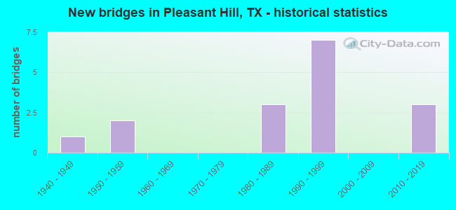
- New bridges - historical statistics
- 11940-1949
- 21950-1959
- 31980-1989
- 71990-1999
- 32010-2019


- Bridge Condition - Deck
- 28.6%Very good
- 64.3%Good
- 7.1%Satisfactory

- Bridge Condition - Superstructure
- 57.1%Very good
- 35.7%Good
- 7.1%Satisfactory

- Bridge Condition - Substructure
- 7.1%Very good
- 71.4%Good
- 7.1%Satisfactory
- 7.1%Fair
- 7.1%Serious

- Bridge Condition - Channel
- 6.3%Very good
- 50.0%Good
- 12.5%Satisfactory
- 31.3%Fair

- Bridge Condition - Culverts
- 50.0%Good
- 50.0%Satisfactory
Find on map >> Show street view
Structure Number: 111870034103034, Location: 3.70 MI E OF US 59 (Lat: 30.979678, Lng: -94.769169), Route carried "on" structure: US 287, Year Built: 1996, Status: Open, Structure Length: 4.57m (14.99ft), Average Daily Traffic: 2,627 (year 2020), Truck Traffic: 21%, Average Future Daily Traffic: 4,240 (year 2033), Design Load: HS 20, Features Intersected: JONES CREEK
Minimum Vertical Clearance: 30+ m (98+ ft), Kilometerpoint: 21.303, Lanes on structure: 2, Owner: State Highway Agency, Approaching Roadway Width: 7.9m (25.9ft), Material/Design: Prestressed concrete, Design/Construction: Stringer/Multi-beam, Number Of Spans In Main Unit: 2, Length of Maximum Span: 22.9m (75.1ft), Curb-To-Curb Width: 13.3m (43.6ft), Out-to-Out Width: 14.1m (46.3ft)
Condition: Deck: Very good, Superstructure: Very good, Substructure: Good, Channel: Good, Operating Rating: 54.4 metric tons, Method Used To Determine Operating Rating: Assigned rating based on Load Factor Design (LFD) reported in metric tons, Inventory Rating: 32.7 metric tons, Method Used To Determine Inventory Rating: Assigned rating based on Load Factor Design (LFD) reported in metric tons, Structural Evaluation: Better than present minimum criteria, Deck Geometry: Equal to present minimum criteria, Waterway Adequacy: Superior to present desirable criteria, Approach Roadway Alignment: Equal to present desirable criteria, Designated Inspection Frequency: Every 24 months, Inspection Date: May 2020, Deck Structure Type: Concrete Cast-file-Place
Find on map >> Show street view
Structure Number: 111870034103035, Location: 3.95 MI E OF US 59 (Lat: 30.978069, Lng: -94.764803), Route carried "on" structure: US 287, Year Built: 1996, Status: Open, Structure Length: 6.10m (20.01ft), Average Daily Traffic: 2,627 (year 2020), Truck Traffic: 21%, Average Future Daily Traffic: 4,240 (year 2033), Design Load: HS 20, Features Intersected: MCMANUS CREEK
Minimum Vertical Clearance: 30+ m (98+ ft), Kilometerpoint: 21.742, Lanes on structure: 2, Owner: State Highway Agency, Approaching Roadway Width: 7.9m (25.9ft), Material/Design: Prestressed concrete, Design/Construction: Stringer/Multi-beam, Number Of Spans In Main Unit: 2, Number Of Approach Spans: 1, Length of Maximum Span: 22.9m (75.1ft), Curb-To-Curb Width: 13.3m (43.6ft), Out-to-Out Width: 14.1m (46.3ft)
Condition: Deck: Good, Superstructure: Very good, Substructure: Good, Channel: Good, Operating Rating: 54.4 metric tons, Method Used To Determine Operating Rating: Assigned rating based on Load Factor Design (LFD) reported in metric tons, Inventory Rating: 32.7 metric tons, Method Used To Determine Inventory Rating: Assigned rating based on Load Factor Design (LFD) reported in metric tons, Structural Evaluation: Better than present minimum criteria, Deck Geometry: Equal to present minimum criteria, Waterway Adequacy: Superior to present desirable criteria, Approach Roadway Alignment: Equal to present desirable criteria, Designated Inspection Frequency: Every 24 months, Inspection Date: May 2020, Deck Structure Type: Concrete Cast-file-Place
Find on map >> Show street view
Structure Number: 111870034103036, Location: 4.10 MI E OF US 59 (Lat: 30.977239, Lng: -94.762472), Route carried "on" structure: US 287, Year Built: 1996, Status: Open, Structure Length: 6.10m (20.01ft), Average Daily Traffic: 2,627 (year 2020), Truck Traffic: 21%, Average Future Daily Traffic: 4,240 (year 2033), Design Load: HS 20, Features Intersected: MCMANUS CRK SLOUGH
Minimum Vertical Clearance: 30+ m (98+ ft), Kilometerpoint: 21.980, Lanes on structure: 2, Owner: State Highway Agency, Approaching Roadway Width: 7.9m (25.9ft), Material/Design: Prestressed concrete, Design/Construction: Stringer/Multi-beam, Number Of Spans In Main Unit: 2, Number Of Approach Spans: 1, Length of Maximum Span: 22.9m (75.1ft), Curb-To-Curb Width: 13.3m (43.6ft), Out-to-Out Width: 14.1m (46.3ft)
Condition: Deck: Good, Superstructure: Very good, Substructure: Very good, Channel: Good, Operating Rating: 54.4 metric tons, Method Used To Determine Operating Rating: Assigned rating based on Load Factor Design (LFD) reported in metric tons, Inventory Rating: 32.7 metric tons, Method Used To Determine Inventory Rating: Assigned rating based on Load Factor Design (LFD) reported in metric tons, Structural Evaluation: Equal to present desirable criteria, Deck Geometry: Equal to present minimum criteria, Waterway Adequacy: Superior to present desirable criteria, Approach Roadway Alignment: Equal to present desirable criteria, Designated Inspection Frequency: Every 24 months, Inspection Date: May 2020, Deck Structure Type: Concrete Cast-file-Place
Find on map >> Show street view
Structure Number: 111870092901003, Location: 2.25 MI E OF US 59 (Lat: 31.012792, Lng: -94.789831), Route carried "on" structure: State highway 352, Year Built: 1948, Year Reconstructed: 2001, Status: Open, Structure Length: 0.88m (2.89ft), Average Daily Traffic: 278 (year 2020), Truck Traffic: 14%, Average Future Daily Traffic: 350 (year 2033), Design Load: H 15, Features Intersected: CREEDS CREEK
Minimum Vertical Clearance: 30+ m (98+ ft), Kilometerpoint: 5.261, Lanes on structure: 2, Owner: State Highway Agency, Approaching Roadway Width: 7.9m (25.9ft), Material/Design: Concrete, Design/Construction: Culvert, Number Of Spans In Main Unit: 5, Length of Maximum Span: 1.5m (4.9ft), Curb-To-Curb Width: 8.7m (28.5ft), Out-to-Out Width: 11.6m (38.1ft)
Condition: Channel: Fair, Culverts: Satisfactory, Operating Rating: 39.9 metric tons, Method Used To Determine Operating Rating: Load Factor (LF), Inventory Rating: 23.6 metric tons, Method Used To Determine Inventory Rating: Load Factor (LF), Structural Evaluation: Equal to present minimum criteria, Deck Geometry: Equal to present minimum criteria, Waterway Adequacy: Better than present minimum criteria, Approach Roadway Alignment: Equal to present desirable criteria, Designated Inspection Frequency: Every 24 months, Inspection Date: April 2020, Deck Structure Type: Concrete Cast-file-Place, Wearing Surface/Protective System: Wearing Surface: Bituminous
Find on map >> Show street view
Structure Number: 111870092901006, Location: 1.35 MI N OF US 287 (Lat: 30.991944, Lng: -94.743586), Route carried "on" structure: State highway 352, Year Built: 1955, Status: Open, Structure Length: 1.52m (4.99ft), Average Daily Traffic: 201 (year 2020), Truck Traffic: 14%, Average Future Daily Traffic: 200 (year 2033), Design Load: H 15, Features Intersected: BEAVER CREEK
Minimum Vertical Clearance: 30+ m (98+ ft), Kilometerpoint: 12.244, Lanes on structure: 2, Owner: State Highway Agency, Approaching Roadway Width: 7.3m (24.0ft), Material/Design: Concrete, Design/Construction: Slab, Number Of Spans In Main Unit: 2, Length of Maximum Span: 7.6m (24.9ft), Curb-To-Curb Width: 7.0m (23.0ft), Out-to-Out Width: 7.7m (25.3ft)
Condition: Deck: Good, Superstructure: Good, Substructure: Satisfactory, Channel: Fair, Operating Rating: 52.6 metric tons, Method Used To Determine Operating Rating: Load Factor (LF), Inventory Rating: 27.2 metric tons, Method Used To Determine Inventory Rating: Load Factor (LF), Structural Evaluation: Equal to present minimum criteria, Deck Geometry: Meets minimum limits, Waterway Adequacy: Better than present minimum criteria, Approach Roadway Alignment: Equal to present desirable criteria, Designated Inspection Frequency: Every 24 months, Inspection Date: April 2020, Deck Structure Type: Concrete Cast-file-Place, Wearing Surface/Protective System: Wearing Surface: Bituminous
Find on map >> Show street view
Structure Number: 111870092901009, Location: 4.10 MI E OF US 59 (Lat: 31.012444, Lng: -94.760311), Route carried "on" structure: State highway 352, Year Built: 1989, Status: Open, Structure Length: 3.69m (12.11ft), Average Daily Traffic: 278 (year 2020), Truck Traffic: 14%, Average Future Daily Traffic: 350 (year 2033), Design Load: HS 20, Features Intersected: MCMANUS CREEK
Minimum Vertical Clearance: 30+ m (98+ ft), Kilometerpoint: 8.262, Lanes on structure: 2, Owner: State Highway Agency, Approaching Roadway Width: 7.3m (24.0ft), Material/Design: Concrete, Design/Construction: Stringer/Multi-beam, Number Of Spans In Main Unit: 4, Length of Maximum Span: 9.1m (29.9ft), Curb-To-Curb Width: 8.9m (29.2ft), Out-to-Out Width: 9.8m (32.2ft)
Condition: Deck: Good, Superstructure: Good, Substructure: Good, Channel: Satisfactory, Operating Rating: 54.4 metric tons, Method Used To Determine Operating Rating: Load Factor (LF), Inventory Rating: 32.7 metric tons, Method Used To Determine Inventory Rating: Load Factor (LF), Structural Evaluation: Better than present minimum criteria, Deck Geometry: Equal to present minimum criteria, Waterway Adequacy: Better than present minimum criteria, Approach Roadway Alignment: Equal to present desirable criteria, Designated Inspection Frequency: Every 24 months, Inspection Date: April 2020, Deck Structure Type: Concrete Cast-file-Place
Find on map >> Show street view
Structure Number: 11187009290101, Location: 4.00 MI E OF US 59 (Lat: 31.012386, Lng: -94.762650), Route carried "on" structure: State highway 352, Year Built: 1989, Status: Open, Structure Length: 1.86m (6.10ft), Average Daily Traffic: 278 (year 2020), Truck Traffic: 14%, Average Future Daily Traffic: 350 (year 2033), Design Load: HS 20, Features Intersected: BOGGY SLOUGH
Minimum Vertical Clearance: 30+ m (98+ ft), Kilometerpoint: 8.060, Lanes on structure: 2, Owner: State Highway Agency, Approaching Roadway Width: 7.3m (24.0ft), Material/Design: Concrete, Design/Construction: Stringer/Multi-beam, Number Of Spans In Main Unit: 2, Length of Maximum Span: 9.1m (29.9ft), Curb-To-Curb Width: 8.9m (29.2ft), Out-to-Out Width: 9.8m (32.2ft)
Condition: Deck: Good, Superstructure: Good, Substructure: Good, Channel: Satisfactory, Operating Rating: 54.4 metric tons, Method Used To Determine Operating Rating: Load Factor (LF), Inventory Rating: 32.7 metric tons, Method Used To Determine Inventory Rating: Load Factor (LF), Structural Evaluation: Better than present minimum criteria, Deck Geometry: Equal to present minimum criteria, Waterway Adequacy: Better than present minimum criteria, Approach Roadway Alignment: Equal to present desirable criteria, Length Of Structure Improvement: 2.32m (7.61ft), Designated Inspection Frequency: Every 24 months, Inspection Date: April 2020, Deck Structure Type: Concrete Cast-file-Place
Find on map >> Show street view
Structure Number: 111870187701009, Location: 3.20 MI NE OF US 59 (Lat: 31.040297, Lng: -94.777153), Route carried "on" structure: State highway 1987, Year Built: 1999, Status: Open, Structure Length: 3.60m (11.81ft), Average Daily Traffic: 189 (year 2020), Truck Traffic: 8%, Average Future Daily Traffic: 160 (year 2033), Design Load: HS 20, Features Intersected: PINEY CREEK RELIEF NO. 1
Minimum Vertical Clearance: 30+ m (98+ ft), Kilometerpoint: 11.246, Lanes on structure: 2, Owner: State Highway Agency, Approaching Roadway Width: 7.3m (24.0ft), Material/Design: Prestressed concrete, Design/Construction: Stringer/Multi-beam, Number Of Spans In Main Unit: 2, Length of Maximum Span: 20.1m (65.9ft), Curb-To-Curb Width: 8.9m (29.2ft), Out-to-Out Width: 9.6m (31.5ft)
Condition: Deck: Good, Superstructure: Very good, Substructure: Good, Channel: Good, Operating Rating: 54.4 metric tons, Method Used To Determine Operating Rating: Assigned rating based on Load Factor Design (LFD) reported in metric tons, Inventory Rating: 32.7 metric tons, Method Used To Determine Inventory Rating: Assigned rating based on Load Factor Design (LFD) reported in metric tons, Structural Evaluation: Better than present minimum criteria, Deck Geometry: Equal to present minimum criteria, Waterway Adequacy: Superior to present desirable criteria, Approach Roadway Alignment: Somewhat better than minimum adequacy, Designated Inspection Frequency: Every 24 months, Underwater Inspection Frequency: Every 60 months, Inspection Date: April 2020, Underwater Inspection Date: November 2019, Deck Structure Type: Concrete Precast Panels
Find on map >> Show street view
Structure Number: 11187018770101, Location: 3.35 MI NE OF US 59 (Lat: 31.041900, Lng: -94.776594), Route carried "on" structure: State highway 1987, Year Built: 1999, Status: Open, Structure Length: 5.21m (17.09ft), Average Daily Traffic: 189 (year 2020), Truck Traffic: 8%, Average Future Daily Traffic: 160 (year 2033), Design Load: HS 20, Features Intersected: PINEY CREEK
Minimum Vertical Clearance: 30+ m (98+ ft), Kilometerpoint: 11.029, Lanes on structure: 2, Owner: State Highway Agency, Approaching Roadway Width: 7.3m (24.0ft), Material/Design: Prestressed concrete, Design/Construction: Stringer/Multi-beam, Number Of Spans In Main Unit: 3, Length of Maximum Span: 20.1m (65.9ft), Curb-To-Curb Width: 8.9m (29.2ft), Out-to-Out Width: 9.6m (31.5ft)
Condition: Deck: Very good, Superstructure: Very good, Substructure: Good, Channel: Good, Operating Rating: 54.4 metric tons, Method Used To Determine Operating Rating: Assigned rating based on Load Factor Design (LFD) reported in metric tons, Inventory Rating: 32.7 metric tons, Method Used To Determine Inventory Rating: Assigned rating based on Load Factor Design (LFD) reported in metric tons, Structural Evaluation: Better than present minimum criteria, Deck Geometry: Equal to present minimum criteria, Waterway Adequacy: Superior to present desirable criteria, Approach Roadway Alignment: Equal to present desirable criteria, Designated Inspection Frequency: Every 24 months, Inspection Date: April 2020, Deck Structure Type: Concrete Precast Panels
Find on map >> Show street view
Structure Number: 111870187701011, Location: 3.45 MI NE OF US 59 (Lat: 31.043044, Lng: -94.776319), Route carried "on" structure: State highway 1987, Year Built: 1999, Status: Open, Structure Length: 2.01m (6.59ft), Average Daily Traffic: 189 (year 2020), Truck Traffic: 8%, Average Future Daily Traffic: 160 (year 2033), Design Load: HS 20, Features Intersected: PINEY CREEK RELIEF NO. 2
Minimum Vertical Clearance: 30+ m (98+ ft), Kilometerpoint: 10.926, Lanes on structure: 2, Owner: State Highway Agency, Approaching Roadway Width: 7.3m (24.0ft), Material/Design: Prestressed concrete, Design/Construction: Stringer/Multi-beam, Number Of Spans In Main Unit: 1, Length of Maximum Span: 20.1m (65.9ft), Curb-To-Curb Width: 8.9m (29.2ft), Out-to-Out Width: 9.6m (31.5ft)
Condition: Deck: Very good, Superstructure: Good, Substructure: Good, Channel: Good, Operating Rating: 54.4 metric tons, Method Used To Determine Operating Rating: Assigned rating based on Load Factor Design (LFD) reported in metric tons, Inventory Rating: 32.7 metric tons, Method Used To Determine Inventory Rating: Assigned rating based on Load Factor Design (LFD) reported in metric tons, Structural Evaluation: Better than present minimum criteria, Deck Geometry: Equal to present minimum criteria, Waterway Adequacy: Superior to present desirable criteria, Approach Roadway Alignment: Equal to present desirable criteria, Designated Inspection Frequency: Every 24 months, Inspection Date: April 2020, Deck Structure Type: Concrete Precast Panels
Find on map >> Show street view
Structure Number: 111870187702002, Location: 3.45 MI SE OF US 59 (Lat: 30.957989, Lng: -94.783511), Route carried "on" structure: State highway 942, Year Built: 1958, Status: Open, Structure Length: 3.81m (12.50ft), Average Daily Traffic: 907 (year 2020), Truck Traffic: 23%, Average Future Daily Traffic: 1,790 (year 2033), Design Load: H 15, Features Intersected: BRUSHY CREEK
Minimum Vertical Clearance: 30+ m (98+ ft), Kilometerpoint: 5.797, Lanes on structure: 2, Owner: State Highway Agency, Approaching Roadway Width: 8.5m (27.9ft), Material/Design: Concrete, Design/Construction: Slab, Number Of Spans In Main Unit: 5, Length of Maximum Span: 7.6m (24.9ft), Curb-To-Curb Width: 7.1m (23.3ft), Out-to-Out Width: 7.7m (25.3ft)
Condition: Deck: Good, Superstructure: Good, Substructure: Fair, Channel: Fair, Operating Rating: 49.0 metric tons, Method Used To Determine Operating Rating: Load Factor (LF), Inventory Rating: 25.4 metric tons, Method Used To Determine Inventory Rating: Load Factor (LF), Structural Evaluation: Somewhat better than minimum adequacy, Deck Geometry: Meets minimum limits, Waterway Adequacy: Equal to present minimum criteria, Approach Roadway Alignment: Equal to present desirable criteria, Length Of Structure Improvement: 3.81m (12.50ft), Designated Inspection Frequency: Every 24 months, Inspection Date: June 2020, Bridge Improvement Cost: $6,000, Roadway Improvement Cost: $2,000, Total Project Cost: $8,000, Deck Structure Type: Concrete Cast-file-Place, Wearing Surface/Protective System: Wearing Surface: Bituminous
Find on map >> Show street view
Structure Number: 111870187702008, Location: 4.50 MI SE OF US 59 (Lat: 30.943908, Lng: -94.778469), Route carried "on" structure: State highway 942, Year Built: 1991, Status: Open, Structure Length: 1.40m (4.59ft), Average Daily Traffic: 847 (year 2020), Truck Traffic: 25%, Average Future Daily Traffic: 1,630 (year 2033), Design Load: HS 20, Features Intersected: JOHNSON CREEK
Minimum Vertical Clearance: 30+ m (98+ ft), Kilometerpoint: 7.519, Lanes on structure: 2, Owner: State Highway Agency, Approaching Roadway Width: 8.5m (27.9ft), Skew: 4 degrees, Material/Design: Concrete, Design/Construction: Culvert, Number Of Spans In Main Unit: 3, Length of Maximum Span: 3.0m (9.8ft)
Condition: Channel: Fair, Culverts: Good, Operating Rating: 39.9 metric tons, Method Used To Determine Operating Rating: Load Factor (LF), Inventory Rating: 23.6 metric tons, Method Used To Determine Inventory Rating: Load Factor (LF), Structural Evaluation: Equal to present minimum criteria, Waterway Adequacy: Equal to present minimum criteria, Approach Roadway Alignment: Equal to present desirable criteria, Designated Inspection Frequency: Every 24 months, Inspection Date: June 2020
Find on map >> Show street view
Structure Number: 111870AA0219009, Location: 1.55 Mi N of FM 352 (Lat: 31.032864, Lng: -94.735225), Route carried "on" structure: County highway , Year Built: 2017, Status: Open, Structure Length: 1.98m (6.50ft), Average Daily Traffic: 50 (year 2015), Average Future Daily Traffic: 80 (year 2035), Design Load: HL 93, Features Intersected: Piney Creek, Facility Carried by Structure: Nine Bridge Road
Minimum Vertical Clearance: 30+ m (98+ ft), Kilometerpoint: 2.494, Lanes on structure: 2, Owner: County Highway Agency, Approaching Roadway Width: 4.9m (16.1ft), Material/Design: Prestressed concrete, Design/Construction: Box Beam or Girders - Multiple, Number Of Spans In Main Unit: 1, Length of Maximum Span: 19.8m (65.0ft), Curb-To-Curb Width: 7.4m (24.3ft), Out-to-Out Width: 8.0m (26.2ft)
Condition: Deck: Very good, Superstructure: Very good, Substructure: Good, Channel: Very good, Operating Rating: 54.4 metric tons, Method Used To Determine Operating Rating: Assigned ratings based on Load and Resistance Factor Design (LRFD) reported in metric tons, Inventory Rating: 32.7 metric tons, Method Used To Determine Inventory Rating: Assigned ratings based on Load and Resistance Factor Design (LRFD) reported in metric tons, Structural Evaluation: Better than present minimum criteria, Deck Geometry: Equal to present minimum criteria, Waterway Adequacy: Better than present minimum criteria, Approach Roadway Alignment: Equal to present desirable criteria, Designated Inspection Frequency: Every 24 months, Inspection Date: June 2021, Deck Structure Type: Concrete Cast-file-Place
Find on map >> Show street view
Structure Number: 111870AA0232003, Location: 0.9 Mi S of US 287 (Lat: 30.960656, Lng: -94.757003), Route carried "on" structure: County highway , Year Built: 2017, Status: Open, Structure Length: 2.13m (6.99ft), Average Daily Traffic: 55 (year 2015), Average Future Daily Traffic: 55 (year 2035), Design Load: HL 93, Features Intersected: North Trib of McManus Cr, Facility Carried by Structure: Jack Pate Road
Minimum Vertical Clearance: 30+ m (98+ ft), Kilometerpoint: 1.448, Lanes on structure: 2, Owner: County Highway Agency, Approaching Roadway Width: 4.9m (16.1ft), Material/Design: Prestressed concrete, Design/Construction: Box Beam or Girders - Multiple, Number Of Spans In Main Unit: 1, Length of Maximum Span: 21.3m (69.9ft), Curb-To-Curb Width: 7.5m (24.6ft), Out-to-Out Width: 8.0m (26.2ft)
Condition: Deck: Good, Superstructure: Very good, Substructure: Good, Channel: Good, Operating Rating: 54.4 metric tons, Method Used To Determine Operating Rating: Assigned ratings based on Load and Resistance Factor Design (LRFD) reported in metric tons, Inventory Rating: 32.7 metric tons, Method Used To Determine Inventory Rating: Assigned ratings based on Load and Resistance Factor Design (LRFD) reported in metric tons, Structural Evaluation: Better than present minimum criteria, Deck Geometry: Equal to present minimum criteria, Waterway Adequacy: Equal to present desirable criteria, Approach Roadway Alignment: Equal to present desirable criteria, Designated Inspection Frequency: Every 24 months, Inspection Date: July 2021, Deck Structure Type: Concrete Cast-file-Place
Find on map >> Show street view
Structure Number: 111870AA0232004, Location: 1.10 Mi S of US 287 (Lat: 30.958514, Lng: -94.759714), Route carried "on" structure: County highway , Year Built: 2017, Status: Open, Structure Length: 2.13m (6.99ft), Average Daily Traffic: 55 (year 2015), Average Future Daily Traffic: 55 (year 2035), Design Load: HL 93, Features Intersected: South Trib of McManus Cr, Facility Carried by Structure: Jack Pate Road
Minimum Vertical Clearance: 30+ m (98+ ft), Kilometerpoint: 1.770, Lanes on structure: 2, Owner: County Highway Agency, Approaching Roadway Width: 4.9m (16.1ft), Material/Design: Prestressed concrete, Design/Construction: Box Beam or Girders - Multiple, Number Of Spans In Main Unit: 1, Length of Maximum Span: 21.3m (69.9ft), Curb-To-Curb Width: 7.5m (24.6ft), Out-to-Out Width: 8.0m (26.2ft)
Condition: Deck: Good, Superstructure: Very good, Substructure: Good, Channel: Good, Operating Rating: 54.4 metric tons, Method Used To Determine Operating Rating: Assigned ratings based on Load and Resistance Factor Design (LRFD) reported in metric tons, Inventory Rating: 32.7 metric tons, Method Used To Determine Inventory Rating: Assigned ratings based on Load and Resistance Factor Design (LRFD) reported in metric tons, Structural Evaluation: Better than present minimum criteria, Deck Geometry: Equal to present minimum criteria, Waterway Adequacy: Equal to present desirable criteria, Approach Roadway Alignment: Equal to present desirable criteria, Designated Inspection Frequency: Every 24 months, Inspection Date: July 2021, Deck Structure Type: Concrete Cast-file-Place
Find on map >> Show street view
Structure Number: 111870AA0233001, Location: 0.75 MI N OF US 287 (Lat: 30.988350, Lng: -94.766283), Route carried "on" structure: County highway , Year Built: 1989, Year Reconstructed: 1997, Status: Posted for load, Structure Length: 1.10m (3.61ft), Average Daily Traffic: 55 (year 2015), Average Future Daily Traffic: 15 (year 2035), Features Intersected: TRIB OF MCMANUS CRK, Facility Carried by Structure: KENNEDY ROAD
Minimum Vertical Clearance: 30+ m (98+ ft), Kilometerpoint: 1.207, Lanes on structure: 1, Owner: County Highway Agency, Approaching Roadway Width: 3.7m (12.1ft), Material/Design: Steel continuous, Design/Construction: Stringer/Multi-beam, Number Of Spans In Main Unit: 2, Length of Maximum Span: 4.9m (16.1ft), Curb-To-Curb Width: 4.5m (14.8ft), Out-to-Out Width: 4.8m (15.7ft)
Condition: Deck: Satisfactory, Superstructure: Satisfactory, Substructure: Serious, Channel: Fair, Operating Rating: 9.1 metric tons, Method Used To Determine Operating Rating: Allowable Stress (AS), Inventory Rating: 5.4 metric tons, Method Used To Determine Inventory Rating: Allowable Stress (AS), Structural Evaluation: High priority of corrective action, Deck Geometry: Equal to present minimum criteria, Waterway Adequacy: Meets minimum limits, Approach Roadway Alignment: Equal to present desirable criteria, Bridge Posting: Required (Relationship of Operating Rating to Maximum Legal Load: > 39.9% below), Designated Inspection Frequency: Every 24 months, Critical Feature Inspection Frequency: Every 24 months, Inspection Date: July 2021, Critical Feature Inspection Date: June 2020, Deck Structure Type: Wood or Timber, Wearing Surface/Protective System: Wearing Surface: Wood or Timber