Bridge Statistics for Plymouth, Nebraska (NE)
Condition, Traffic, Stress, Structural Evaluation, Project Costs
- National Bridge Inventory (NBI) Statistics
- 17Number of bridges
- 69ft / 20.9mTotal length
- 2,785Total average daily traffic
- 142Total average daily truck traffic
- National Bridge Inventory (NBI) Registered Bridges for Plymouth
- No street view available for this location
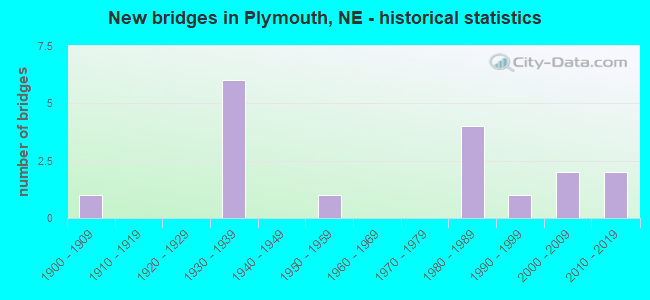
- New bridges - historical statistics
- 11900-1909
- 61930-1939
- 11950-1959
- 41980-1989
- 11990-1999
- 22000-2009
- 22010-2019

- Bridge Condition - Deck
- 42.9%Good
- 14.3%Satisfactory
- 28.6%Fair
- 14.3%Failed

- Bridge Condition - Superstructure
- 14.3%Very good
- 14.3%Good
- 14.3%Satisfactory
- 28.6%Fair
- 28.6%Poor

- Bridge Condition - Substructure
- 14.3%Very good
- 14.3%Good
- 14.3%Satisfactory
- 57.1%Fair

- Bridge Condition - Channel
- 12.5%Excellent
- 18.8%Very good
- 6.3%Good
- 12.5%Satisfactory
- 37.5%Fair
- 12.5%Poor

- Bridge Condition - Culverts
- 44.4%Excellent
- 33.3%Very good
- 11.1%Satisfactory
- 11.1%Fair
Find on map >> Show street view
Structure Number: C00480143, Location: 3S 1.5W OF PLYMOUTH (Lat: 40.262600, Lng: -97.018600), Route carried "on" structure: County highway 7734, Year Built: 1935, Status: Posted for load, Structure Length: 1.04m (3.41ft), Average Daily Traffic: 50 (year 1998), Average Future Daily Traffic: 85 (year 2033), Features Intersected: STREAM
Minimum Vertical Clearance: 30+ m (98+ ft), Kilometerpoint: 2.337, Lanes on structure: 2, Owner: County Highway Agency, Approaching Roadway Width: 8.5m (27.9ft), Material/Design: Steel, Design/Construction: Stringer/Multi-beam, Number Of Spans In Main Unit: 1, Length of Maximum Span: 10.1m (33.1ft), Curb-To-Curb Width: 8.0m (26.2ft), Out-to-Out Width: 8.0m (26.2ft)
Condition: Deck: Good, Superstructure: Fair, Substructure: Fair, Channel: Poor, Operating Rating: 15.0 metric tons, Method Used To Determine Operating Rating: Load Factor (LF), Inventory Rating: 8.0 metric tons, Method Used To Determine Inventory Rating: Load Factor (LF), Structural Evaluation: High priority of replacement, Deck Geometry: Equal to present minimum criteria, Waterway Adequacy: Better than present minimum criteria, Approach Roadway Alignment: Better than present minimum criteria, Bridge Posting: Required (Relationship of Operating Rating to Maximum Legal Load: > 39.9% below), Length Of Structure Improvement: 1.04m (3.41ft), Designated Inspection Frequency: Every 24 months, Inspection Date: October 2021, Deck Structure Type: Concrete Cast-file-Place, Wearing Surface/Protective System: Wearing Surface: Monolithic Concrete
Find on map >> Show street view
Structure Number: C004801435, Location: 3S 1.7E OF PLYMOUTH (Lat: 40.263000, Lng: -96.957000), Route carried "on" structure: County highway 7734, Year Built: 2019, Status: Open, Structure Length: 0.75m (2.46ft), Average Daily Traffic: 75 (year 1998), Average Future Daily Traffic: 127 (year 2033), Design Load: HL 93, Features Intersected: CUB CREEK, Facility Carried by Structure: 720 RD
Minimum Vertical Clearance: 30+ m (98+ ft), Kilometerpoint: 2.858, Lanes on structure: 2, Owner: County Highway Agency, Approaching Roadway Width: 8.5m (27.9ft), Material/Design: Concrete, Design/Construction: Culvert, Number Of Spans In Main Unit: 2, Length of Maximum Span: 3.7m (12.1ft)
Condition: Channel: Excellent, Culverts: Excellent, Operating Rating: 35.0 metric tons, Method Used To Determine Operating Rating: Load and Resistance Factor (LRFR), Inventory Rating: 27.0 metric tons, Method Used To Determine Inventory Rating: Load and Resistance Factor (LRFR), Structural Evaluation: Equal to present minimum criteria, Waterway Adequacy: Equal to present desirable criteria, Approach Roadway Alignment: Equal to present desirable criteria, Length Of Structure Improvement: 0.70m (2.30ft), Designated Inspection Frequency: Every 24 months, Inspection Date: October 2020
Find on map >> Show street view
Structure Number: C00480392, Location: 1W 3.2S OF PLYMOUTH (Lat: 40.258300, Lng: -97.010000), Route carried "on" structure: County highway 39, Year Built: 1935, Status: Posted for load, Structure Length: 2.50m (8.20ft), Average Daily Traffic: 40 (year 2003), Average Future Daily Traffic: 68 (year 2033), Design Load: HS 20, Features Intersected: CUB CREEK, Facility Carried by Structure: 577 AVE
Minimum Vertical Clearance: 30+ m (98+ ft), Kilometerpoint: 0.000, Lanes on structure: 1, Owner: County Highway Agency, Approaching Roadway Width: 6.1m (20.0ft), Material/Design: Steel, Design/Construction: Truss - Thru, Number Of Spans In Main Unit: 1, Length of Maximum Span: 24.4m (80.1ft), Curb-To-Curb Width: 4.7m (15.4ft), Out-to-Out Width: 4.8m (15.7ft)
Condition: Deck: Fair, Superstructure: Poor, Substructure: Fair, Channel: Fair, Operating Rating: 24.0 metric tons, Method Used To Determine Operating Rating: Load Factor (LF), Inventory Rating: 14.0 metric tons, Method Used To Determine Inventory Rating: Load Factor (LF), Structural Evaluation: Meets minimum limits, Deck Geometry: Better than present minimum criteria, Waterway Adequacy: Somewhat better than minimum adequacy, Approach Roadway Alignment: Equal to present minimum criteria, Bridge Posting: Required (Relationship of Operating Rating to Maximum Legal Load: 20.0 - 29.9% below), Length Of Structure Improvement: 2.47m (8.10ft), Designated Inspection Frequency: Every 24 months, Critical Feature Inspection Frequency: Every 24 months, Inspection Date: June 2021, Critical Feature Inspection Date: June 2021, Deck Structure Type: Wood or Timber, Wearing Surface/Protective System: Wearing Surface: Wood or Timber
Find on map >> Show street view
Structure Number: C00480412, Location: JCT N4/N103 4.1W 4.3S (Lat: 40.245400, Lng: -96.992300), Route carried "on" structure: County highway 3015, Year Built: 2002, Status: Open, Structure Length: 3.35m (10.99ft), Average Daily Traffic: 615 (year 2011), Average Future Daily Traffic: 615 (year 2033), Design Load: HS 20, Features Intersected: CUB CREEK
Minimum Vertical Clearance: 30+ m (98+ ft), Kilometerpoint: 3.030, Lanes on structure: 2, Owner: County Highway Agency, Approaching Roadway Width: 7.3m (24.0ft), Material/Design: Concrete continuous, Design/Construction: Slab, Number Of Spans In Main Unit: 3, Length of Maximum Span: 13.4m (44.0ft), Curb-To-Curb Width: 8.5m (27.9ft), Out-to-Out Width: 9.2m (30.2ft)
Condition: Deck: Good, Superstructure: Very good, Substructure: Very good, Channel: Very good, Operating Rating: 71.0 metric tons, Method Used To Determine Operating Rating: Load Factor (LF), Inventory Rating: 37.0 metric tons, Method Used To Determine Inventory Rating: Load Factor (LF), Structural Evaluation: Equal to present desirable criteria, Deck Geometry: Somewhat better than minimum adequacy, Waterway Adequacy: Superior to present desirable criteria, Approach Roadway Alignment: Equal to present desirable criteria, Length Of Structure Improvement: 3.57m (11.71ft), Designated Inspection Frequency: Every 24 months, Inspection Date: October 2021, Deck Structure Type: Concrete Cast-file-Place, Wearing Surface/Protective System: Wearing Surface: Monolithic Concrete
Find on map >> Show street view
Structure Number: C004804123, Location: JCT N4/N103 4.1W 2S (Lat: 40.276700, Lng: -96.991700), Route carried "on" structure: County highway 3015, Year Built: 1987, Status: Open, Structure Length: 1.34m (4.40ft), Average Daily Traffic: 615 (year 2011), Average Future Daily Traffic: 615 (year 2033), Features Intersected: STREAM
Minimum Vertical Clearance: 30+ m (98+ ft), Kilometerpoint: 3.388, Lanes on structure: 2, Owner: County Highway Agency, Approaching Roadway Width: 9.8m (32.2ft), Skew: 4 degrees, Material/Design: Concrete, Design/Construction: Culvert, Number Of Spans In Main Unit: 3, Length of Maximum Span: 3.0m (9.8ft)
Condition: Channel: Fair, Culverts: Very good, Operating Rating: 33.0 metric tons, Method Used To Determine Operating Rating: Field evaluation and documented engineering judgment, Inventory Rating: 22.0 metric tons, Method Used To Determine Inventory Rating: Field evaluation and documented engineering judgment, Structural Evaluation: Somewhat better than minimum adequacy, Waterway Adequacy: Superior to present desirable criteria, Approach Roadway Alignment: Equal to present desirable criteria, Designated Inspection Frequency: Every 24 months, Inspection Date: October 2021
Find on map >> Show street view
Structure Number: C004804325, Location: .5E 3.5S OF PLYMOUTH (Lat: 40.248300, Lng: -96.973300), Route carried "on" structure: County highway 43, Year Built: 1950, Status: Open, Structure Length: 1.83m (6.00ft), Average Daily Traffic: 45 (year 2003), Average Future Daily Traffic: 76 (year 2033), Features Intersected: CUB CREEK, Facility Carried by Structure: COUNTY HIGHWAY
Minimum Vertical Clearance: 30+ m (98+ ft), Kilometerpoint: 0.000, Lanes on structure: 2, Owner: County Highway Agency, Approaching Roadway Width: 8.2m (26.9ft), Material/Design: Steel, Design/Construction: Stringer/Multi-beam, Number Of Spans In Main Unit: 1, Length of Maximum Span: 18.0m (59.1ft), Curb-To-Curb Width: 7.9m (25.9ft), Out-to-Out Width: 7.9m (25.9ft)
Condition: Deck: Good, Superstructure: Satisfactory, Substructure: Satisfactory, Channel: Fair, Operating Rating: 34.0 metric tons, Method Used To Determine Operating Rating: Load Factor (LF), Inventory Rating: 20.0 metric tons, Method Used To Determine Inventory Rating: Load Factor (LF), Structural Evaluation: Somewhat better than minimum adequacy, Deck Geometry: Equal to present minimum criteria, Waterway Adequacy: Equal to present minimum criteria, Approach Roadway Alignment: Equal to present desirable criteria, Designated Inspection Frequency: Every 24 months, Inspection Date: October 2021, Deck Structure Type: Concrete Cast-file-Place, Wearing Surface/Protective System: Wearing Surface: Monolithic Concrete
Find on map >> Show street view
Structure Number: C00481101, Location: .5S 1.4W OF PLYMOUTH (Lat: 40.291600, Lng: -97.019700), Route carried "on" structure: County highway 110, Year Built: 2017, Status: Open, Structure Length: 0.90m (2.95ft), Average Daily Traffic: 30 (year 2003), Average Future Daily Traffic: 51 (year 2033), Design Load: HL 93, Features Intersected: CUB CREEK TRIB, Facility Carried by Structure: 722 RD
Minimum Vertical Clearance: 30+ m (98+ ft), Kilometerpoint: 0.000, Lanes on structure: 2, Owner: County Highway Agency, Approaching Roadway Width: 7.0m (23.0ft), Material/Design: Concrete, Design/Construction: Culvert, Number Of Spans In Main Unit: 3, Length of Maximum Span: 2.7m (8.9ft)
Condition: Channel: Very good, Culverts: Excellent, Operating Rating: 55.0 metric tons, Method Used To Determine Operating Rating: Load and Resistance Factor (LRFR), Inventory Rating: 43.0 metric tons, Method Used To Determine Inventory Rating: Load and Resistance Factor (LRFR), Structural Evaluation: Superior to present desirable criteria, Waterway Adequacy: Equal to present desirable criteria, Approach Roadway Alignment: Equal to present desirable criteria, Length Of Structure Improvement: 0.73m (2.40ft), Designated Inspection Frequency: Every 24 months, Inspection Date: October 2020
Find on map >> Show street view
Structure Number: C00481451, Location: 1.5E 1.7N OF PLYMOUTH (Lat: 40.331700, Lng: -96.953300), Route carried "on" structure: County highway 145, Year Built: 1980, Status: Open, Structure Length: 1.25m (4.10ft), Average Daily Traffic: 35 (year 2003), Average Future Daily Traffic: 59 (year 2033), Features Intersected: STREAM, Facility Carried by Structure: COUNTY HIGHWAY
Minimum Vertical Clearance: 30+ m (98+ ft), Kilometerpoint: 0.000, Lanes on structure: 2, Owner: County Highway Agency, Approaching Roadway Width: 7.0m (23.0ft), Material/Design: Steel, Design/Construction: Stringer/Multi-beam, Number Of Spans In Main Unit: 1, Length of Maximum Span: 11.9m (39.0ft), Curb-To-Curb Width: 7.8m (25.6ft), Out-to-Out Width: 8.0m (26.2ft)
Condition: Deck: Satisfactory, Superstructure: Good, Substructure: Good, Channel: Fair, Operating Rating: 39.0 metric tons, Method Used To Determine Operating Rating: Load Factor (LF), Inventory Rating: 24.0 metric tons, Method Used To Determine Inventory Rating: Load Factor (LF), Structural Evaluation: Equal to present minimum criteria, Deck Geometry: Equal to present minimum criteria, Waterway Adequacy: Equal to present minimum criteria, Approach Roadway Alignment: Equal to present minimum criteria, Designated Inspection Frequency: Every 24 months, Inspection Date: October 2021, Deck Structure Type: Concrete Cast-file-Place, Wearing Surface/Protective System: Wearing Surface: Monolithic Concrete
Find on map >> Show street view
Structure Number: C004814735, Location: 3E 2.5S OF PLYMOUTH (Lat: 40.268300, Lng: -96.935000), Route carried "on" structure: County highway 7737, Year Built: 1935, Status: Open, Structure Length: 0.67m (2.20ft), Average Daily Traffic: 60 (year 1998), Average Future Daily Traffic: 102 (year 2033), Features Intersected: STREAM
Minimum Vertical Clearance: 30+ m (98+ ft), Kilometerpoint: 0.657, Lanes on structure: 2, Owner: County Highway Agency, Approaching Roadway Width: 8.5m (27.9ft), Material/Design: Steel, Design/Construction: Culvert, Number Of Spans In Main Unit: 3, Length of Maximum Span: 1.8m (5.9ft)
Condition: Channel: Poor, Culverts: Fair, Operating Rating: 34.0 metric tons, Method Used To Determine Operating Rating: Field evaluation and documented engineering judgment, Inventory Rating: 33.0 metric tons, Method Used To Determine Inventory Rating: Field evaluation and documented engineering judgment, Structural Evaluation: Somewhat better than minimum adequacy, Waterway Adequacy: Superior to present desirable criteria, Approach Roadway Alignment: Equal to present desirable criteria, Length Of Structure Improvement: 0.03m (0.10ft), Designated Inspection Frequency: Every 24 months, Inspection Date: October 2021
Find on map >> Show street view
Structure Number: C00481474, Location: 2.5E 1.2N OF PLYMOUTH (Lat: 40.323300, Lng: -96.935000), Route carried "on" structure: County highway 147, Year Built: 1998, Status: Open, Structure Length: 0.82m (2.69ft), Average Daily Traffic: 40 (year 2003), Average Future Daily Traffic: 68 (year 2033), Features Intersected: STREAM, Facility Carried by Structure: COUNTY HIGHWAY
Minimum Vertical Clearance: 30+ m (98+ ft), Kilometerpoint: 0.000, Lanes on structure: 2, Owner: County Highway Agency, Approaching Roadway Width: 8.5m (27.9ft), Material/Design: Steel, Design/Construction: Culvert, Number Of Spans In Main Unit: 3, Length of Maximum Span: 2.1m (6.9ft)
Condition: Channel: Good, Culverts: Excellent, Operating Rating: 43.0 metric tons, Method Used To Determine Operating Rating: Field evaluation and documented engineering judgment, Inventory Rating: 33.0 metric tons, Method Used To Determine Inventory Rating: Field evaluation and documented engineering judgment, Structural Evaluation: Superior to present desirable criteria, Waterway Adequacy: Better than present minimum criteria, Approach Roadway Alignment: Equal to present desirable criteria, Length Of Structure Improvement: 0.73m (2.40ft), Designated Inspection Frequency: Every 24 months, Inspection Date: October 2021
Find on map >> Show street view
Structure Number: C004814745, Location: 2.5E 1.9N OF PLYMOUTH (Lat: 40.333000, Lng: -96.935100), Route carried "on" structure: County highway 147, Year Built: 1935, Status: Posted for load, Structure Length: 1.07m (3.51ft), Average Daily Traffic: 40 (year 2003), Average Future Daily Traffic: 68 (year 2033), Features Intersected: STREAM, Facility Carried by Structure: 581 AVE
Minimum Vertical Clearance: 30+ m (98+ ft), Kilometerpoint: 0.000, Lanes on structure: 1, Owner: County Highway Agency, Approaching Roadway Width: 6.1m (20.0ft), Material/Design: Steel, Design/Construction: Girder and Floorbeam System, Number Of Spans In Main Unit: 1, Length of Maximum Span: 10.1m (33.1ft), Curb-To-Curb Width: 4.9m (16.1ft), Out-to-Out Width: 5.1m (16.7ft)
Condition: Deck: Fair, Superstructure: Fair, Substructure: Fair, Channel: Fair, Operating Rating: 15.0 metric tons, Method Used To Determine Operating Rating: Load Factor (LF), Inventory Rating: 9.0 metric tons, Method Used To Determine Inventory Rating: Load Factor (LF), Structural Evaluation: High priority of replacement, Deck Geometry: High priority of corrective action, Waterway Adequacy: Somewhat better than minimum adequacy, Approach Roadway Alignment: Equal to present desirable criteria, Bridge Posting: Required (Relationship of Operating Rating to Maximum Legal Load: > 39.9% below), Length Of Structure Improvement: 1.04m (3.41ft), Designated Inspection Frequency: Every 24 months, Critical Feature Inspection Frequency: Every 24 months, Inspection Date: June 2021, Critical Feature Inspection Date: June 2021, Deck Structure Type: Concrete Cast-file-Place, Wearing Surface/Protective System: Wearing Surface: Monolithic Concrete
Find on map >> Show street view
Structure Number: C004820425, Location: 2N 2.7E OF PLYMOUTH (Lat: 40.335000, Lng: -96.941700), Route carried "on" structure: County highway 204, Year Built: 1988, Status: Open, Structure Length: 0.98m (3.22ft), Average Daily Traffic: 35 (year 2003), Average Future Daily Traffic: 59 (year 2033), Design Load: HS 20, Features Intersected: STREAM, Facility Carried by Structure: COUNTY HIGHWAY
Minimum Vertical Clearance: 30+ m (98+ ft), Kilometerpoint: 0.000, Lanes on structure: 2, Owner: County Highway Agency, Approaching Roadway Width: 8.5m (27.9ft), Skew: 1 degrees, Material/Design: Concrete, Design/Construction: Culvert, Number Of Spans In Main Unit: 3, Length of Maximum Span: 3.0m (9.8ft)
Condition: Channel: Very good, Culverts: Very good, Operating Rating: 33.0 metric tons, Method Used To Determine Operating Rating: Field evaluation and documented engineering judgment, Inventory Rating: 22.0 metric tons, Method Used To Determine Inventory Rating: Field evaluation and documented engineering judgment, Structural Evaluation: Equal to present minimum criteria, Waterway Adequacy: Equal to present desirable criteria, Approach Roadway Alignment: Equal to present desirable criteria, Designated Inspection Frequency: Every 24 months, Inspection Date: October 2020
Find on map >> Show street view
Structure Number: C00482043, Location: 2N 2.9E OF PLYMOUTH (Lat: 40.335000, Lng: -96.936700), Route carried "on" structure: County highway 204, Year Built: 1988, Status: Open, Structure Length: 0.64m (2.10ft), Average Daily Traffic: 35 (year 2003), Average Future Daily Traffic: 59 (year 2033), Design Load: HS 20, Features Intersected: STREAM, Facility Carried by Structure: COUNTY HIGHWAY
Minimum Vertical Clearance: 30+ m (98+ ft), Kilometerpoint: 0.000, Lanes on structure: 2, Owner: County Highway Agency, Approaching Roadway Width: 8.5m (27.9ft), Material/Design: Concrete, Design/Construction: Culvert, Number Of Spans In Main Unit: 2, Length of Maximum Span: 3.0m (9.8ft)
Condition: Channel: Satisfactory, Culverts: Very good, Operating Rating: 33.0 metric tons, Method Used To Determine Operating Rating: Field evaluation and documented engineering judgment, Inventory Rating: 22.0 metric tons, Method Used To Determine Inventory Rating: Field evaluation and documented engineering judgment, Structural Evaluation: Equal to present minimum criteria, Waterway Adequacy: Equal to present desirable criteria, Approach Roadway Alignment: Equal to present desirable criteria, Designated Inspection Frequency: Every 24 months, Inspection Date: October 2020
Find on map >> Show street view
Structure Number: C004823715, Location: 2W 3.5S OF PLYMOUTH (Lat: 40.258300, Lng: -97.028300), Route carried "on" structure: County highway 237, Year Built: 1905, Status: Closed, Structure Length: 1.86m (6.10ft), Average Daily Traffic: 5 (year 2003), Average Future Daily Traffic: 8 (year 2033), Features Intersected: CUB CREEK, Facility Carried by Structure: 576 AVE
Minimum Vertical Clearance: 30+ m (98+ ft), Kilometerpoint: 0.000, Lanes on structure: 1, Owner: County Highway Agency, Approaching Roadway Width: 5.5m (18.0ft), Material/Design: Steel, Design/Construction: Truss - Thru, Number Of Spans In Main Unit: 1, Length of Maximum Span: 18.0m (59.1ft), Curb-To-Curb Width: 4.3m (14.1ft), Out-to-Out Width: 4.9m (16.1ft)
Condition: Deck: Failed, Superstructure: Poor, Substructure: Fair, Channel: Fair, Deck Geometry: Equal to present minimum criteria, Waterway Adequacy: Meets minimum limits, Approach Roadway Alignment: High priority of corrective action, Bridge Posting: Required (Relationship of Operating Rating to Maximum Legal Load: > 39.9% below), Length Of Structure Improvement: 1.83m (6.00ft), Designated Inspection Frequency: Every 24 months, Critical Feature Inspection Frequency: Every 24 months, Other Special Inspection Frequency: Every 24 months, Inspection Date: June 2015, Critical Feature Inspection Date: June 2015, Other Special Inspection Date: January 2001, Deck Structure Type: Wood or Timber, Wearing Surface/Protective System: Wearing Surface: Wood or Timber
Find on map >> Show street view
Structure Number: C00760504, Location: 8E N15 JEFFERSON CL (Lat: 40.350000, Lng: -97.006700), Route carried "on" structure: County highway 50, Year Built: 2000, Status: Open, Structure Length: 1.19m (3.90ft), Average Daily Traffic: 30 (year 2003), Average Future Daily Traffic: 43 (year 2033), Features Intersected: STREAM, Facility Carried by Structure: COUNTY HIGHWAY
Minimum Vertical Clearance: 30+ m (98+ ft), Kilometerpoint: 0.000, Lanes on structure: 2, Owner: County Highway Agency, Approaching Roadway Width: 8.5m (27.9ft), Skew: 2 degrees, Material/Design: Concrete, Design/Construction: Culvert, Number Of Spans In Main Unit: 3, Length of Maximum Span: 3.7m (12.1ft)
Condition: Channel: Excellent, Culverts: Excellent, Operating Rating: 33.0 metric tons, Method Used To Determine Operating Rating: Field evaluation and documented engineering judgment, Inventory Rating: 22.0 metric tons, Method Used To Determine Inventory Rating: Field evaluation and documented engineering judgment, Structural Evaluation: Equal to present minimum criteria, Waterway Adequacy: Superior to present desirable criteria, Approach Roadway Alignment: Equal to present desirable criteria, Designated Inspection Frequency: Every 24 months, Inspection Date: November 2020
Find on map >> Show street view
Structure Number: S004 14054, Location: JCT N4/N103 7.1W (Lat: 40.306000, Lng: -97.047900), Route carried "on" structure: State highway 4, Year Built: 1935, Status: Open, Structure Length: 0.70m (2.30ft), Average Daily Traffic: 1,015 (year 2018), Truck Traffic: 14%, Average Future Daily Traffic: 1,472 (year 2038), Design Load: HS 20, Features Intersected: STREAM
Minimum Vertical Clearance: 30+ m (98+ ft), Kilometerpoint: 22.618, Lanes on structure: 2, Base Highway Network: Yes, Owner: State Highway Agency, Approaching Roadway Width: 7.3m (24.0ft), Skew: 4 degrees, Material/Design: Concrete, Design/Construction: Culvert, Number Of Spans In Main Unit: 2, Length of Maximum Span: 2.4m (7.9ft)
Condition: Channel: Satisfactory, Culverts: Satisfactory, Operating Rating: 43.0 metric tons, Method Used To Determine Operating Rating: Field evaluation and documented engineering judgment, Inventory Rating: 33.0 metric tons, Method Used To Determine Inventory Rating: Field evaluation and documented engineering judgment, Structural Evaluation: Equal to present minimum criteria, Waterway Adequacy: Equal to present minimum criteria, Approach Roadway Alignment: Equal to present desirable criteria, Designated Inspection Frequency: Every 24 months, Inspection Date: August 2020
Find on map >> Show street view
Structure Number: C004814515, Location: 1.5E 2.2N OF PLYMOUTH (Lat: 40.336700, Lng: -96.953300), Route carried "under" structure: County highway 145, Year Built: 1935, Structure Length: 0. m, Average Daily Traffic: 20 (year 2003), Features Intersected: UPRR 598-694-J, Facility Carried by Structure: UPRR
Minimum Vertical Clearance: 3.96m (12.99ft), Kilometerpoint: 0.000, Lanes under structure: 2, Material/Design: Steel, Design/Construction: Stringer/Multi-beam, Length of Maximum Span: 13.1m (43.0ft)