Bridge Statistics for Plymouth, Wisconsin (WI)
Condition, Traffic, Stress, Structural Evaluation, Project Costs
- National Bridge Inventory (NBI) Statistics
- 43Number of bridges
- 364ft / 111mTotal length
- $969,000Total costs
- 179,526Total average daily traffic
- 8,684Total average daily truck traffic
- National Bridge Inventory (NBI) Registered Bridges for Plymouth
- No street view available for this location
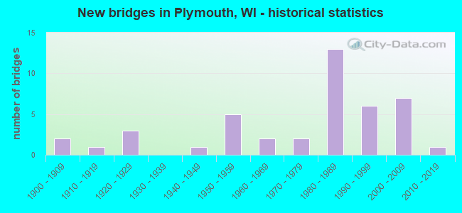
- New bridges - historical statistics
- 21900-1909
- 11910-1919
- 31920-1929
- 11940-1949
- 51950-1959
- 21960-1969
- 21970-1979
- 131980-1989
- 61990-1999
- 72000-2009
- 12010-2019

- Reconstructed bridges - Historical Statistics
- 21960-1969
- 01970-1979
- 21980-1989
- 11990-1999
- 12000-2009


- Bridge Condition - Deck
- 3.6%Excellent
- 7.1%Very good
- 35.7%Good
- 17.9%Satisfactory
- 28.6%Fair
- 7.1%Poor

- Bridge Condition - Superstructure
- 3.6%Excellent
- 17.9%Very good
- 32.1%Good
- 3.6%Satisfactory
- 28.6%Fair
- 10.7%Poor
- 3.6%Serious

- Bridge Condition - Substructure
- 3.6%Excellent
- 14.3%Very good
- 50.0%Good
- 10.7%Satisfactory
- 14.3%Fair
- 7.1%Poor

- Bridge Condition - Channel
- 6.9%Excellent
- 72.4%Very good
- 3.4%Good
- 10.3%Satisfactory
- 6.9%Fair

- Bridge Condition - Culverts
- 16.7%Very good
- 33.3%Good
- 50.0%Satisfactory
Find on map >> Show street view
Structure Number: B590004, Location: 0.5M N JCT STH 23 (Lat: 43.760472, Lng: -87.941083), Route carried "on" structure: State highway 57, Year Built: 1955, Year Reconstructed: 1989, Status: Open, Structure Length: 0.89m (2.92ft), Average Daily Traffic: 9,700 (year 2020), Truck Traffic: 8%, Average Future Daily Traffic: 16,500 (year 2039), Design Load: HS 20, Features Intersected: BR MULLET RIVER
Minimum Vertical Clearance: 30+ m (98+ ft), Kilometerpoint: 0.000, Lanes on structure: 4, Base Highway Network: Yes, Owner: State Highway Agency, Approaching Roadway Width: 13.4m (44.0ft), Skew: 4 degrees, Material/Design: Concrete continuous, Design/Construction: Culvert, Number Of Spans In Main Unit: 2, Length of Maximum Span: 3.0m (9.8ft)
Condition: Channel: Very good, Culverts: Satisfactory, Operating Rating: 53.9 metric tons, Method Used To Determine Operating Rating: Field evaluation and documented engineering judgment, Inventory Rating: 32.4 metric tons, Method Used To Determine Inventory Rating: Field evaluation and documented engineering judgment, Structural Evaluation: Equal to present minimum criteria, Waterway Adequacy: Equal to present desirable criteria, Approach Roadway Alignment: Equal to present desirable criteria, Designated Inspection Frequency: Every 24 months, Inspection Date: June 2020, Deck Structure Type: Concrete Cast-file-Place, Wearing Surface/Protective System: Wearing Surface: Bituminous
Find on map >> Show street view
Structure Number: B590005, Location: 1.9M N JCT CTH O (Lat: 43.789531, Lng: -87.941722), Route carried "on" structure: State highway 57, Year Built: 1955, Year Reconstructed: 1990, Status: Open, Structure Length: 1.31m (4.30ft), Average Daily Traffic: 8,300 (year 2020), Truck Traffic: 8%, Average Future Daily Traffic: 9,990 (year 2039), Design Load: H 20, Features Intersected: OTTER CREEK
Minimum Vertical Clearance: 30+ m (98+ ft), Kilometerpoint: 0.000, Lanes on structure: 2, Base Highway Network: Yes, Owner: State Highway Agency, Approaching Roadway Width: 13.4m (44.0ft), Skew: 3 degrees, Material/Design: Steel, Design/Construction: Stringer/Multi-beam, Number Of Spans In Main Unit: 1, Length of Maximum Span: 12.9m (42.3ft), Curb-To-Curb Width: 12.8m (42.0ft), Out-to-Out Width: 13.4m (44.0ft)
Condition: Deck: Good, Superstructure: Very good, Substructure: Fair, Channel: Very good, Operating Rating: 44.1 metric tons, Method Used To Determine Operating Rating: Load Factor (LF), Inventory Rating: 25.9 metric tons, Method Used To Determine Inventory Rating: Load Factor (LF), Structural Evaluation: Somewhat better than minimum adequacy, Deck Geometry: Somewhat better than minimum adequacy, Waterway Adequacy: Equal to present desirable criteria, Approach Roadway Alignment: Equal to present desirable criteria, Designated Inspection Frequency: Every 24 months, Inspection Date: June 2020, Deck Structure Type: Concrete Cast-file-Place, Wearing Surface/Protective System: Wearing Surface: Monolithic Concrete, Deck Protection: Epoxy Coated Reinforcing
Find on map >> Show street view
Structure Number: B590015, Location: 2.8M N JCT STH 28 TO E (Lat: 43.721697, Lng: -87.940536), Route carried "on" structure: State highway 57, Year Built: 1961, Year Reconstructed: 1980, Status: Open, Structure Length: 1.24m (4.07ft), Average Daily Traffic: 9,700 (year 2020), Truck Traffic: 8%, Average Future Daily Traffic: 7,665 (year 2039), Design Load: HS 20, Features Intersected: MULLET RIVER
Minimum Vertical Clearance: 30+ m (98+ ft), Kilometerpoint: 0.000, Lanes on structure: 4, Base Highway Network: Yes, Owner: State Highway Agency, Approaching Roadway Width: 12.2m (40.0ft), Skew: 1 degrees, Material/Design: Concrete continuous, Design/Construction: Culvert, Number Of Spans In Main Unit: 3, Length of Maximum Span: 3.7m (12.1ft)
Condition: Channel: Very good, Culverts: Satisfactory, Operating Rating: 53.9 metric tons, Method Used To Determine Operating Rating: Field evaluation and documented engineering judgment, Inventory Rating: 32.4 metric tons, Method Used To Determine Inventory Rating: Field evaluation and documented engineering judgment, Structural Evaluation: Equal to present minimum criteria, Waterway Adequacy: Equal to present desirable criteria, Approach Roadway Alignment: Equal to present desirable criteria, Designated Inspection Frequency: Every 24 months, Inspection Date: June 2020, Deck Structure Type: Concrete Cast-file-Place, Wearing Surface/Protective System: Wearing Surface: Monolithic Concrete
Find on map >> Show street view
Structure Number: B590031, Location: 0.2M E JCT STH 57 (Lat: 43.790644, Lng: -87.937314), Route carried "on" structure: County highway , Year Built: 1967, Status: Open, Structure Length: 0.70m (2.30ft), Average Daily Traffic: 1,938 (year 2019), Average Future Daily Traffic: 2,131 (year 2040), Design Load: H 20, Features Intersected: OTTER CREEK, Facility Carried by Structure: CTH J
Minimum Vertical Clearance: 30+ m (98+ ft), Kilometerpoint: 0.000, Lanes on structure: 2, Owner: County Highway Agency, Approaching Roadway Width: 9.8m (32.2ft), Skew: 1 degrees, Material/Design: Concrete continuous, Design/Construction: Culvert, Number Of Spans In Main Unit: 2, Length of Maximum Span: 3.0m (9.8ft)
Condition: Channel: Satisfactory, Culverts: Good, Operating Rating: 53.9 metric tons, Method Used To Determine Operating Rating: Field evaluation and documented engineering judgment, Inventory Rating: 24.3 metric tons, Method Used To Determine Inventory Rating: Field evaluation and documented engineering judgment, Structural Evaluation: Equal to present minimum criteria, Waterway Adequacy: Equal to present minimum criteria, Approach Roadway Alignment: Equal to present desirable criteria, Designated Inspection Frequency: Every 24 months, Inspection Date: October 2021, Deck Structure Type: Concrete Cast-file-Place, Wearing Surface/Protective System: Wearing Surface: Bituminous
Find on map >> Show street view
Structure Number: B590032, Location: 0.4M E JCT STH 57 (Lat: 43.790658, Lng: -87.933619), Route carried "on" structure: County highway , Year Built: 1920, Year Reconstructed: 1967, Status: Open, Structure Length: 1.01m (3.31ft), Average Daily Traffic: 1,938 (year 2019), Average Future Daily Traffic: 2,131 (year 2040), Design Load: H 15, Features Intersected: OTTER CREEK, Facility Carried by Structure: CTH J
Minimum Vertical Clearance: 30+ m (98+ ft), Kilometerpoint: 0.000, Lanes on structure: 2, Owner: County Highway Agency, Approaching Roadway Width: 11.0m (36.1ft), Material/Design: Concrete, Design/Construction: Stringer/Multi-beam, Number Of Spans In Main Unit: 1, Length of Maximum Span: 9.6m (31.5ft), Curb-To-Curb Width: 9.1m (29.9ft), Out-to-Out Width: 9.9m (32.5ft)
Condition: Deck: Good, Superstructure: Good, Substructure: Fair, Channel: Satisfactory, Operating Rating: 34.3 metric tons, Method Used To Determine Operating Rating: Load Factor (LF), Inventory Rating: 17.8 metric tons, Method Used To Determine Inventory Rating: Load Factor (LF), Structural Evaluation: Meets minimum limits, Deck Geometry: Somewhat better than minimum adequacy, Waterway Adequacy: Equal to present desirable criteria, Approach Roadway Alignment: Equal to present desirable criteria, Designated Inspection Frequency: Every 24 months, Inspection Date: October 2021, Deck Structure Type: Concrete Cast-file-Place, Wearing Surface/Protective System: Wearing Surface: Bituminous
Find on map >> Show street view
Structure Number: B590085, Location: 0.4M E JCT STH 67 TO N (Lat: 43.746667, Lng: -87.971667), Route carried "on" structure: County highway , Year Built: 1976, Status: Open, Structure Length: 1.51m (4.95ft), Average Daily Traffic: 18,847 (year 2019), Average Future Daily Traffic: 20,731 (year 2039), Design Load: HS 20, Features Intersected: MULLET RIVER, Facility Carried by Structure: CTH EASTERN AVE.
Minimum Vertical Clearance: 30+ m (98+ ft), Kilometerpoint: 0.000, Lanes on structure: 2, Owner: City or Municipal Highway Agency, Approaching Roadway Width: 14.0m (45.9ft), Material/Design: Prestressed concrete, Design/Construction: Stringer/Multi-beam, Number Of Spans In Main Unit: 1, Length of Maximum Span: 14.9m (48.9ft), Curb or Sidewalk Widths: Left: 2.0m (6.6ft), Right: 2.0m (6.6ft), Curb-To-Curb Width: 14.0m (45.9ft), Out-to-Out Width: 18.3m (60.0ft)
Condition: Deck: Good, Superstructure: Good, Substructure: Good, Channel: Very good, Operating Rating: 55.5 metric tons, Method Used To Determine Operating Rating: Load Factor (LF), Inventory Rating: 35.6 metric tons, Method Used To Determine Inventory Rating: Load Factor (LF), Structural Evaluation: Better than present minimum criteria, Deck Geometry: Superior to present desirable criteria, Waterway Adequacy: Equal to present desirable criteria, Approach Roadway Alignment: Equal to present desirable criteria, Designated Inspection Frequency: Every 24 months, Inspection Date: July 2020, Deck Structure Type: Concrete Cast-file-Place, Wearing Surface/Protective System: Wearing Surface: Monolithic Concrete
Find on map >> Show street view
Structure Number: B590091, Location: 1.0M E JCT CTH C (Lat: 43.761106, Lng: -87.981497), Route carried "on" structure: State highway 23, Year Built: 1985, Status: Open, Structure Length: 12.00m (39.37ft), Average Daily Traffic: 8,000 (year 2020), Truck Traffic: 8%, Average Future Daily Traffic: 21,840 (year 2039), Design Load: HS 20, Features Intersected: STH 67
Minimum Vertical Clearance: 30+ m (98+ ft), Kilometerpoint: 0.000, Lanes on structure: 3, Lanes under structure: 2, Base Highway Network: Yes, Owner: State Highway Agency, Approaching Roadway Width: 13.4m (44.0ft), Skew: 2 degrees, Material/Design: Steel continuous, Design/Construction: Stringer/Multi-beam, Number Of Spans In Main Unit: 3, Length of Maximum Span: 40.2m (131.9ft), Curb-To-Curb Width: 17.6m (57.7ft), Out-to-Out Width: 18.5m (60.7ft)
Condition: Deck: Satisfactory, Superstructure: Good, Substructure: Good, Channel: Very good, Operating Rating: 67.0 metric tons, Method Used To Determine Operating Rating: Load Factor (LF), Inventory Rating: 40.5 metric tons, Method Used To Determine Inventory Rating: Load Factor (LF), Structural Evaluation: Better than present minimum criteria, Deck Geometry: Superior to present desirable criteria, Underclear: Meets minimum limits, Waterway Adequacy: Equal to present desirable criteria, Approach Roadway Alignment: Equal to present desirable criteria, Designated Inspection Frequency: Every 24 months, Inspection Date: September 2020, Deck Structure Type: Concrete Cast-file-Place, Wearing Surface/Protective System: Wearing Surface: Monolithic Concrete, Deck Protection: Epoxy Coated Reinforcing
Find on map >> Show street view
Structure Number: B590092, Location: AT JCT STH 23-STH 57 (Lat: 43.756931, Lng: -87.941742), Route carried "on" structure: State highway 23, Year Built: 1984, Status: Open, Structure Length: 7.89m (25.89ft), Average Daily Traffic: 9,300 (year 2020), Truck Traffic: 8%, Average Future Daily Traffic: 14,247 (year 2039), Design Load: HS 20, Features Intersected: STH 57
Minimum Vertical Clearance: 30+ m (98+ ft), Kilometerpoint: 0.000, Lanes on structure: 2, Lanes under structure: 4, Base Highway Network: Yes, Owner: State Highway Agency, Approaching Roadway Width: 13.4m (44.0ft), Skew: 2 degrees, Material/Design: Steel continuous, Design/Construction: Stringer/Multi-beam, Number Of Spans In Main Unit: 2, Length of Maximum Span: 38.6m (126.6ft), Curb-To-Curb Width: 13.4m (44.0ft), Out-to-Out Width: 14.3m (46.9ft)
Condition: Deck: Satisfactory, Superstructure: Good, Substructure: Good, Operating Rating: 67.0 metric tons, Method Used To Determine Operating Rating: Load Factor (LF), Inventory Rating: 38.9 metric tons, Method Used To Determine Inventory Rating: Load Factor (LF), Structural Evaluation: Better than present minimum criteria, Deck Geometry: Superior to present desirable criteria, Underclear: Equal to present desirable criteria, Approach Roadway Alignment: Equal to present desirable criteria, Designated Inspection Frequency: Every 24 months, Inspection Date: July 2020, Deck Structure Type: Concrete Cast-file-Place, Wearing Surface/Protective System: Wearing Surface: Monolithic Concrete, Deck Protection: Epoxy Coated Reinforcing
Find on map >> Show street view
Structure Number: B590093, Location: AT JCT STH 23-STH 57 (Lat: 43.757019, Lng: -87.940878), Route carried "on" structure: State highway 23, Year Built: 1989, Status: Open, Structure Length: 7.89m (25.89ft), Average Daily Traffic: 9,300 (year 2020), Truck Traffic: 8%, Average Future Daily Traffic: 13,752 (year 2039), Design Load: HS 20, Features Intersected: STH 57
Minimum Vertical Clearance: 30+ m (98+ ft), Kilometerpoint: 0.000, Lanes on structure: 2, Lanes under structure: 4, Base Highway Network: Yes, Owner: State Highway Agency, Approaching Roadway Width: 13.4m (44.0ft), Skew: 2 degrees, Material/Design: Steel continuous, Design/Construction: Stringer/Multi-beam, Number Of Spans In Main Unit: 2, Length of Maximum Span: 38.6m (126.6ft), Curb-To-Curb Width: 12.2m (40.0ft), Out-to-Out Width: 13.1m (43.0ft)
Condition: Deck: Good, Superstructure: Good, Substructure: Good, Operating Rating: 67.0 metric tons, Method Used To Determine Operating Rating: Load Factor (LF), Inventory Rating: 38.9 metric tons, Method Used To Determine Inventory Rating: Load Factor (LF), Structural Evaluation: Better than present minimum criteria, Deck Geometry: Better than present minimum criteria, Underclear: Equal to present desirable criteria, Approach Roadway Alignment: Equal to present desirable criteria, Designated Inspection Frequency: Every 48 months, Inspection Date: July 2020, Deck Structure Type: Concrete Cast-file-Place, Wearing Surface/Protective System: Wearing Surface: Monolithic Concrete, Deck Protection: Epoxy Coated Reinforcing
Find on map >> Show street view
Structure Number: B590097, Location: 0.5M E JCT CTH C (Lat: 43.761733, Lng: -87.992381), Route carried "on" structure: State highway 23, Year Built: 1985, Status: Open, Structure Length: 8.49m (27.85ft), Average Daily Traffic: 6,100 (year 2020), Truck Traffic: 8%, Average Future Daily Traffic: 18,280 (year 2039), Design Load: HS 20, Features Intersected: LRD SUNSET DRIVE / RR
Minimum Vertical Clearance: 30+ m (98+ ft), Kilometerpoint: 0.000, Lanes on structure: 2, Lanes under structure: 4, Base Highway Network: Yes, Owner: State Highway Agency, Approaching Roadway Width: 13.4m (44.0ft), Skew: 3 degrees, Material/Design: Steel continuous, Design/Construction: Stringer/Multi-beam, Number Of Spans In Main Unit: 3, Length of Maximum Span: 29.9m (98.1ft), Curb-To-Curb Width: 13.4m (44.0ft), Out-to-Out Width: 14.3m (46.9ft)
Condition: Deck: Satisfactory, Superstructure: Good, Substructure: Good, Operating Rating: 65.0 metric tons, Method Used To Determine Operating Rating: Load Factor (LF), Inventory Rating: 38.9 metric tons, Method Used To Determine Inventory Rating: Load Factor (LF), Structural Evaluation: Better than present minimum criteria, Deck Geometry: Superior to present desirable criteria, Underclear: Equal to present minimum criteria, Approach Roadway Alignment: Equal to present desirable criteria, Designated Inspection Frequency: Every 24 months, Inspection Date: July 2020, Deck Structure Type: Concrete Cast-file-Place, Wearing Surface/Protective System: Wearing Surface: Monolithic Concrete, Deck Protection: Epoxy Coated Reinforcing
Find on map >> Show street view
Structure Number: B590108, Location: 0.8M N JCT STH 23 (Lat: 43.766308, Lng: -87.982636), Route carried "on" structure: State highway 67, Year Built: 1981, Status: Open, Structure Length: 2.47m (8.10ft), Average Daily Traffic: 5,900 (year 2020), Truck Traffic: 6%, Average Future Daily Traffic: 8,000 (year 2039), Design Load: HS 20, Features Intersected: MULLET RIVER
Minimum Vertical Clearance: 30+ m (98+ ft), Kilometerpoint: 0.000, Lanes on structure: 2, Owner: State Highway Agency, Approaching Roadway Width: 12.2m (40.0ft), Skew: 3 degrees, Material/Design: Steel, Design/Construction: Stringer/Multi-beam, Number Of Spans In Main Unit: 1, Length of Maximum Span: 24.4m (80.1ft), Curb-To-Curb Width: 12.2m (40.0ft), Out-to-Out Width: 13.1m (43.0ft)
Condition: Deck: Good, Superstructure: Good, Substructure: Satisfactory, Channel: Very good, Operating Rating: 62.1 metric tons, Method Used To Determine Operating Rating: Load Factor (LF), Inventory Rating: 35.6 metric tons, Method Used To Determine Inventory Rating: Load Factor (LF), Structural Evaluation: Equal to present minimum criteria, Deck Geometry: Somewhat better than minimum adequacy, Waterway Adequacy: Equal to present desirable criteria, Approach Roadway Alignment: Equal to present desirable criteria, Designated Inspection Frequency: Every 24 months, Inspection Date: June 2020, Deck Structure Type: Concrete Cast-file-Place, Wearing Surface/Protective System: Wearing Surface: Low Slump Concrete
Find on map >> Show street view
Structure Number: B590111, Location: 1.1M E JCT STH 57 (Lat: 43.776450, Lng: -87.913603), Route carried "on" structure: City street , Year Built: 1981, Status: Open, Structure Length: 4.14m (13.58ft), Average Daily Traffic: 35 (year 2019), Average Future Daily Traffic: 38 (year 2039), Design Load: H 20, Features Intersected: SHEBOYGAN RIVER, Facility Carried by Structure: LRD WOODLAND RD
Minimum Vertical Clearance: 30+ m (98+ ft), Kilometerpoint: 0.000, Lanes on structure: 2, Owner: Town or Township Highway Agency, Approaching Roadway Width: 8.5m (27.9ft), Skew: 1 degrees, Material/Design: Concrete continuous, Design/Construction: Slab, Number Of Spans In Main Unit: 3, Length of Maximum Span: 16.5m (54.1ft), Curb-To-Curb Width: 8.5m (27.9ft), Out-to-Out Width: 9.1m (29.9ft)
Condition: Deck: Satisfactory, Superstructure: Satisfactory, Substructure: Good, Channel: Very good, Operating Rating: 55.5 metric tons, Method Used To Determine Operating Rating: Load Factor (LF), Inventory Rating: 32.4 metric tons, Method Used To Determine Inventory Rating: Load Factor (LF), Structural Evaluation: Equal to present minimum criteria, Deck Geometry: Better than present minimum criteria, Waterway Adequacy: Equal to present desirable criteria, Approach Roadway Alignment: Equal to present desirable criteria, Designated Inspection Frequency: Every 24 months, Inspection Date: August 2020, Deck Structure Type: Concrete Cast-file-Place, Wearing Surface/Protective System: Wearing Surface: Monolithic Concrete
Find on map >> Show street view
Structure Number: B590112, Location: 0.1M W JCT STH 67 (Lat: 43.745228, Lng: -87.983386), Route carried "on" structure: City street , Year Built: 1981, Status: Open, Structure Length: 1.32m (4.33ft), Average Daily Traffic: 400 (year 2019), Average Future Daily Traffic: 401 (year 2039), Design Load: H 20, Features Intersected: MULLET RIVER, Facility Carried by Structure: LRD FREDERICK ST (
Minimum Vertical Clearance: 30+ m (98+ ft), Kilometerpoint: 0.000, Lanes on structure: 2, Owner: City or Municipal Highway Agency, Approaching Roadway Width: 9.1m (29.9ft), Skew: 1 degrees, Material/Design: Concrete, Design/Construction: Slab, Number Of Spans In Main Unit: 1, Length of Maximum Span: 12.6m (41.3ft), Curb or Sidewalk Widths: Left: 0.0m, Right: 2.0m (6.6ft), Curb-To-Curb Width: 9.1m (29.9ft), Out-to-Out Width: 11.3m (37.1ft)
Condition: Deck: Fair, Superstructure: Fair, Substructure: Good, Channel: Very good, Operating Rating: 52.3 metric tons, Method Used To Determine Operating Rating: Load Factor (LF), Inventory Rating: 30.8 metric tons, Method Used To Determine Inventory Rating: Load Factor (LF), Structural Evaluation: Somewhat better than minimum adequacy, Deck Geometry: Equal to present minimum criteria, Waterway Adequacy: Equal to present desirable criteria, Approach Roadway Alignment: Equal to present desirable criteria, Designated Inspection Frequency: Every 24 months, Inspection Date: July 2020, Deck Structure Type: Concrete Cast-file-Place, Wearing Surface/Protective System: Wearing Surface: Monolithic Concrete
Find on map >> Show street view
Structure Number: B590119, Location: 0.1M N JCT CTH SR (Lat: 43.790728, Lng: -87.916342), Route carried "on" structure: County highway , Year Built: 1991, Status: Open, Structure Length: 1.96m (6.43ft), Average Daily Traffic: 622 (year 2019), Average Future Daily Traffic: 684 (year 2040), Design Load: HS 20, Features Intersected: SHEBOYGAN RIVER, Facility Carried by Structure: CTH J
Minimum Vertical Clearance: 30+ m (98+ ft), Kilometerpoint: 0.000, Lanes on structure: 2, Owner: County Highway Agency, Approaching Roadway Width: 9.1m (29.9ft), Material/Design: Prestressed concrete, Design/Construction: Stringer/Multi-beam, Number Of Spans In Main Unit: 1, Length of Maximum Span: 19.1m (62.7ft), Curb or Sidewalk Widths: Left: 2.8m (9.2ft), Right: 0.0m, Curb-To-Curb Width: 9.1m (29.9ft), Out-to-Out Width: 12.3m (40.4ft)
Condition: Deck: Good, Superstructure: Very good, Substructure: Very good, Channel: Very good, Operating Rating: 65.0 metric tons, Method Used To Determine Operating Rating: Load Factor (LF), Inventory Rating: 38.9 metric tons, Method Used To Determine Inventory Rating: Load Factor (LF), Structural Evaluation: Equal to present desirable criteria, Deck Geometry: Equal to present minimum criteria, Waterway Adequacy: Equal to present desirable criteria, Approach Roadway Alignment: Equal to present desirable criteria, Designated Inspection Frequency: Every 48 months, Inspection Date: September 2021, Deck Structure Type: Concrete Cast-file-Place, Wearing Surface/Protective System: Wearing Surface: Monolithic Concrete, Deck Protection: Epoxy Coated Reinforcing
Find on map >> Show street view
Structure Number: B590121, Location: 0.4M N JCT CTH O (Lat: 43.770383, Lng: -87.909078), Route carried "on" structure: City street , Year Built: 1984, Status: Open, Structure Length: 3.35m (10.99ft), Average Daily Traffic: 117 (year 2019), Average Future Daily Traffic: 128 (year 2039), Design Load: H 20, Features Intersected: SHEBOYGAN RIVER, Facility Carried by Structure: LRD RIO RD
Minimum Vertical Clearance: 30+ m (98+ ft), Kilometerpoint: 0.000, Lanes on structure: 2, Owner: Town or Township Highway Agency, Approaching Roadway Width: 8.5m (27.9ft), Skew: 2 degrees, Material/Design: Concrete continuous, Design/Construction: Slab, Number Of Spans In Main Unit: 2, Length of Maximum Span: 16.5m (54.1ft), Curb-To-Curb Width: 7.3m (24.0ft), Out-to-Out Width: 7.9m (25.9ft)
Condition: Deck: Fair, Superstructure: Fair, Substructure: Very good, Channel: Very good, Operating Rating: 49.0 metric tons, Method Used To Determine Operating Rating: Load Factor (LF), Inventory Rating: 29.2 metric tons, Method Used To Determine Inventory Rating: Load Factor (LF), Structural Evaluation: Somewhat better than minimum adequacy, Deck Geometry: Somewhat better than minimum adequacy, Waterway Adequacy: Equal to present desirable criteria, Approach Roadway Alignment: Equal to present desirable criteria, Designated Inspection Frequency: Every 24 months, Inspection Date: August 2020, Deck Structure Type: Concrete Cast-file-Place, Wearing Surface/Protective System: Wearing Surface: Monolithic Concrete
Find on map >> Show street view
Structure Number: B590132, Location: 0.9M N JCT CTH O (Lat: 43.779964, Lng: -87.901133), Route carried "on" structure: County highway , Year Built: 1989, Status: Open, Structure Length: 4.39m (14.40ft), Average Daily Traffic: 292 (year 2019), Average Future Daily Traffic: 321 (year 2040), Design Load: HS 20, Features Intersected: SHEBOYGAN RIVER, Facility Carried by Structure: CTH M
Minimum Vertical Clearance: 30+ m (98+ ft), Kilometerpoint: 0.000, Lanes on structure: 2, Owner: County Highway Agency, Approaching Roadway Width: 9.1m (29.9ft), Skew: 3 degrees, Material/Design: Concrete continuous, Design/Construction: Slab, Number Of Spans In Main Unit: 3, Length of Maximum Span: 17.7m (58.1ft), Curb-To-Curb Width: 8.5m (27.9ft), Out-to-Out Width: 9.1m (29.9ft)
Condition: Deck: Fair, Superstructure: Fair, Substructure: Good, Channel: Fair, Operating Rating: 71.8 metric tons, Method Used To Determine Operating Rating: Load Factor (LF), Inventory Rating: 42.1 metric tons, Method Used To Determine Inventory Rating: Load Factor (LF), Structural Evaluation: Somewhat better than minimum adequacy, Deck Geometry: Equal to present minimum criteria, Waterway Adequacy: Equal to present desirable criteria, Approach Roadway Alignment: Equal to present desirable criteria, Designated Inspection Frequency: Every 24 months, Inspection Date: July 2021, Deck Structure Type: Concrete Cast-file-Place, Wearing Surface/Protective System: Wearing Surface: Monolithic Concrete, Deck Protection: Epoxy Coated Reinforcing
Find on map >> Show street view
Structure Number: B590137, Location: 0.3M N JCT CTH PP (Lat: 43.736683, Lng: -87.980961), Route carried "on" structure: State highway 67, Year Built: 1990, Status: Open, Structure Length: 1.21m (3.97ft), Average Daily Traffic: 3,200 (year 2020), Truck Traffic: 4%, Average Future Daily Traffic: 6,270 (year 2039), Design Load: HS 20, Features Intersected: MULLET RIVER
Minimum Vertical Clearance: 30+ m (98+ ft), Kilometerpoint: 0.000, Lanes on structure: 2, Owner: State Highway Agency, Approaching Roadway Width: 12.2m (40.0ft), Skew: 1 degrees, Material/Design: Concrete continuous, Design/Construction: Culvert, Number Of Spans In Main Unit: 3, Length of Maximum Span: 3.7m (12.1ft)
Condition: Channel: Very good, Culverts: Good, Operating Rating: 53.9 metric tons, Method Used To Determine Operating Rating: Field evaluation and documented engineering judgment, Inventory Rating: 32.4 metric tons, Method Used To Determine Inventory Rating: Field evaluation and documented engineering judgment, Structural Evaluation: Better than present minimum criteria, Waterway Adequacy: Equal to present desirable criteria, Approach Roadway Alignment: Equal to present desirable criteria, Designated Inspection Frequency: Every 48 months, Inspection Date: June 2020, Deck Structure Type: Concrete Cast-file-Place, Wearing Surface/Protective System: Wearing Surface: Bituminous
Find on map >> Show street view
Structure Number: B590138, Location: 1.0M N JCT CTH PP (Lat: 43.747158, Lng: -87.981158), Route carried "on" structure: State highway 67, Year Built: 1990, Status: Open, Structure Length: 1.28m (4.20ft), Average Daily Traffic: 4,313 (year 2019), Truck Traffic: 6%, Average Future Daily Traffic: 4,744 (year 2039), Design Load: HS 20, Features Intersected: MULLET RIVER
Minimum Vertical Clearance: 30+ m (98+ ft), Kilometerpoint: 0.000, Lanes on structure: 2, Owner: City or Municipal Highway Agency, Approaching Roadway Width: 12.8m (42.0ft), Skew: 1 degrees, Material/Design: Concrete, Design/Construction: Slab, Number Of Spans In Main Unit: 1, Length of Maximum Span: 12.2m (40.0ft), Curb or Sidewalk Widths: Left: 2.0m (6.6ft), Right: 2.0m (6.6ft), Curb-To-Curb Width: 12.8m (42.0ft), Out-to-Out Width: 16.5m (54.1ft)
Condition: Deck: Good, Superstructure: Good, Substructure: Good, Channel: Very good, Operating Rating: 62.1 metric tons, Method Used To Determine Operating Rating: Load Factor (LF), Inventory Rating: 37.3 metric tons, Method Used To Determine Inventory Rating: Load Factor (LF), Structural Evaluation: Better than present minimum criteria, Deck Geometry: Equal to present minimum criteria, Waterway Adequacy: Equal to present desirable criteria, Approach Roadway Alignment: Equal to present desirable criteria, Designated Inspection Frequency: Every 48 months, Inspection Date: July 2020, Deck Structure Type: Concrete Cast-file-Place, Wearing Surface/Protective System: Wearing Surface: Monolithic Concrete, Deck Protection: Epoxy Coated Reinforcing
Find on map >> Show street view
Structure Number: B590151, Location: 0.4M W JCT CTH M (Lat: 43.798217, Lng: -87.909792), Route carried "on" structure: County highway , Year Built: 1991, Status: Open, Structure Length: 3.53m (11.58ft), Average Daily Traffic: 450 (year 2019), Average Future Daily Traffic: 495 (year 2040), Design Load: HS 20, Features Intersected: SHEBOYGAN RIVER, Facility Carried by Structure: CTH JM
Minimum Vertical Clearance: 30+ m (98+ ft), Kilometerpoint: 0.000, Lanes on structure: 2, Owner: County Highway Agency, Approaching Roadway Width: 10.4m (34.1ft), Material/Design: Concrete continuous, Design/Construction: Slab, Number Of Spans In Main Unit: 2, Length of Maximum Span: 17.4m (57.1ft), Curb or Sidewalk Widths: Left: 2.0m (6.6ft), Right: 0.0m, Curb-To-Curb Width: 9.1m (29.9ft), Out-to-Out Width: 11.3m (37.1ft)
Condition: Deck: Fair, Superstructure: Fair, Substructure: Good, Channel: Very good, Operating Rating: 57.0 metric tons, Method Used To Determine Operating Rating: Load Factor (LF), Inventory Rating: 34.0 metric tons, Method Used To Determine Inventory Rating: Load Factor (LF), Structural Evaluation: Somewhat better than minimum adequacy, Deck Geometry: Equal to present minimum criteria, Waterway Adequacy: Equal to present desirable criteria, Approach Roadway Alignment: Equal to present desirable criteria, Designated Inspection Frequency: Every 24 months, Inspection Date: October 2021, Deck Structure Type: Concrete Cast-file-Place, Wearing Surface/Protective System: Wearing Surface: Monolithic Concrete, Deck Protection: Epoxy Coated Reinforcing
Find on map >> Show street view
Structure Number: B590157, Location: 0.6M S JCT CTH PP (Lat: 43.723667, Lng: -87.961511), Route carried "on" structure: City street , Year Built: 1993, Status: Open, Structure Length: 1.77m (5.81ft), Average Daily Traffic: 784 (year 2019), Average Future Daily Traffic: 862 (year 2039), Design Load: HS 20, Features Intersected: MULLET RIVER, Facility Carried by Structure: LRD BLUEBERRY LA
Minimum Vertical Clearance: 30+ m (98+ ft), Kilometerpoint: 0.000, Lanes on structure: 2, Owner: Town or Township Highway Agency, Approaching Roadway Width: 8.5m (27.9ft), Skew: 2 degrees, Material/Design: Concrete continuous, Design/Construction: Slab, Number Of Spans In Main Unit: 2, Length of Maximum Span: 8.5m (27.9ft), Curb-To-Curb Width: 8.5m (27.9ft), Out-to-Out Width: 9.1m (29.9ft)
Condition: Deck: Fair, Superstructure: Fair, Substructure: Good, Channel: Very good, Operating Rating: 63.7 metric tons, Method Used To Determine Operating Rating: Load Factor (LF), Inventory Rating: 37.3 metric tons, Method Used To Determine Inventory Rating: Load Factor (LF), Structural Evaluation: Somewhat better than minimum adequacy, Deck Geometry: Somewhat better than minimum adequacy, Waterway Adequacy: Equal to present desirable criteria, Approach Roadway Alignment: Equal to present desirable criteria, Designated Inspection Frequency: Every 24 months, Inspection Date: September 2020, Deck Structure Type: Concrete Cast-file-Place, Wearing Surface/Protective System: Wearing Surface: Monolithic Concrete, Deck Protection: Epoxy Coated Reinforcing
Find on map >> Show street view
Structure Number: B59017, Location: 0.2M N JCT CTH A (Lat: 43.835333, Lng: -87.902186), Route carried "on" structure: City street , Year Built: 1998, Status: Open, Structure Length: 3.18m (10.43ft), Average Daily Traffic: 277 (year 2019), Average Future Daily Traffic: 304 (year 2039), Design Load: HS 20, Features Intersected: SHEBOYGAN RIVER, Facility Carried by Structure: LRD MAIN RD
Minimum Vertical Clearance: 30+ m (98+ ft), Kilometerpoint: 0.000, Lanes on structure: 2, Owner: Town or Township Highway Agency, Approaching Roadway Width: 10.4m (34.1ft), Material/Design: Concrete continuous, Design/Construction: Slab, Number Of Spans In Main Unit: 2, Length of Maximum Span: 15.5m (50.9ft), Curb-To-Curb Width: 9.0m (29.5ft), Out-to-Out Width: 9.6m (31.5ft)
Condition: Deck: Fair, Superstructure: Fair, Substructure: Very good, Channel: Very good, Operating Rating: 62.1 metric tons, Method Used To Determine Operating Rating: Load Factor (LF), Inventory Rating: 37.3 metric tons, Method Used To Determine Inventory Rating: Load Factor (LF), Structural Evaluation: Somewhat better than minimum adequacy, Deck Geometry: Equal to present minimum criteria, Waterway Adequacy: Equal to present desirable criteria, Approach Roadway Alignment: Equal to present desirable criteria, Designated Inspection Frequency: Every 24 months, Inspection Date: November 2020, Deck Structure Type: Concrete Cast-file-Place, Wearing Surface/Protective System: Wearing Surface: Monolithic Concrete, Deck Protection: Epoxy Coated Reinforcing
Find on map >> Show street view
Structure Number: B590179, Location: AT STH 23 (Lat: 43.761650, Lng: -88.001983), Route carried "on" structure: County highway , Year Built: 2005, Status: Open, Structure Length: 8.35m (27.40ft), Average Daily Traffic: 3,100 (year 2020), Average Future Daily Traffic: 9,100 (year 2039), Design Load: HS 20, Features Intersected: STH 23, Facility Carried by Structure: CTH C
Minimum Vertical Clearance: 30+ m (98+ ft), Kilometerpoint: 0.000, Lanes on structure: 2, Lanes under structure: 6, Owner: State Highway Agency, Approaching Roadway Width: 13.4m (44.0ft), Skew: 20 degrees, Material/Design: Prestressed concrete continuous, Design/Construction: Stringer/Multi-beam, Number Of Spans In Main Unit: 2, Length of Maximum Span: 41.1m (134.8ft), Curb or Sidewalk Widths: Left: 0.0m, Right: 2.0m (6.6ft), Curb-To-Curb Width: 15.8m (51.8ft), Out-to-Out Width: 22.2m (72.8ft)
Condition: Deck: Very good, Superstructure: Very good, Substructure: Very good, Operating Rating: 93.1 metric tons, Method Used To Determine Operating Rating: Load Factor (LF), Inventory Rating: 37.3 metric tons, Method Used To Determine Inventory Rating: Load Factor (LF), Structural Evaluation: Equal to present desirable criteria, Deck Geometry: Superior to present desirable criteria, Underclear: Equal to present minimum criteria, Approach Roadway Alignment: Equal to present desirable criteria, Designated Inspection Frequency: Every 48 months, Inspection Date: July 2020, Deck Structure Type: Concrete Cast-file-Place, Wearing Surface/Protective System: Wearing Surface: Monolithic Concrete, Deck Protection: Epoxy Coated Reinforcing
Find on map >> Show street view
Structure Number: B59018, Location: 0.8M W JCT STH 67 (Lat: 43.761944, Lng: -87.991617), Route carried "on" structure: State highway 23, Year Built: 2004, Status: Open, Structure Length: 8.63m (28.31ft), Average Daily Traffic: 6,100 (year 2020), Average Future Daily Traffic: 19,400 (year 2039), Design Load: HS 20, Features Intersected: SUNSET DRIVE/R/R
Minimum Vertical Clearance: 30+ m (98+ ft), Kilometerpoint: 0.000, Lanes on structure: 2, Lanes under structure: 5, Base Highway Network: Yes, Owner: State Highway Agency, Approaching Roadway Width: 12.2m (40.0ft), Skew: 3 degrees, Material/Design: Prestressed concrete continuous, Design/Construction: Stringer/Multi-beam, Number Of Spans In Main Unit: 3, Length of Maximum Span: 29.9m (98.1ft), Curb-To-Curb Width: 12.2m (40.0ft), Out-to-Out Width: 13.0m (42.7ft)
Condition: Deck: Good, Superstructure: Very good, Substructure: Good, Operating Rating: 65.0 metric tons, Method Used To Determine Operating Rating: Load Factor (LF), Inventory Rating: 34.0 metric tons, Method Used To Determine Inventory Rating: Load Factor (LF), Structural Evaluation: Better than present minimum criteria, Deck Geometry: Better than present minimum criteria, Underclear: Somewhat better than minimum adequacy, Approach Roadway Alignment: Equal to present desirable criteria, Designated Inspection Frequency: Every 48 months, Inspection Date: July 2020, Deck Structure Type: Concrete Cast-file-Place, Wearing Surface/Protective System: Wearing Surface: Monolithic Concrete, Deck Protection: Epoxy Coated Reinforcing
Find on map >> Show street view
Structure Number: B590204, Location: 0.4M E JCT CTH C (Lat: 43.775914, Lng: -87.993981), Route carried "on" structure: City street , Year Built: 2019, Status: Open, Structure Length: 1.42m (4.66ft), Average Daily Traffic: 1,000 (year 2019), Truck Traffic: 4%, Average Future Daily Traffic: 1,300 (year 2039), Design Load: HL 93, Features Intersected: MULLET RIVER, Facility Carried by Structure: LRD WOODLAND RD
Minimum Vertical Clearance: 30+ m (98+ ft), Kilometerpoint: 0.000, Lanes on structure: 2, Owner: Town or Township Highway Agency, Approaching Roadway Width: 9.1m (29.9ft), Skew: 2 degrees, Material/Design: Concrete, Design/Construction: Slab, Number Of Spans In Main Unit: 1, Length of Maximum Span: 13.4m (44.0ft), Curb or Sidewalk Widths: Left: 0.0m, Right: 2.0m (6.6ft), Curb-To-Curb Width: 9.1m (29.9ft), Out-to-Out Width: 12.0m (39.4ft)
Condition: Deck: Excellent, Superstructure: Excellent, Substructure: Excellent, Channel: Excellent, Operating Rating: 48.0 metric tons, Method Used To Determine Operating Rating: Load and Resistance Factor Rating (LRFR) rating reported by rating factor(RF) method using HL-93 loadings, Inventory Rating: 36.9 metric tons, Method Used To Determine Inventory Rating: Load and Resistance Factor Rating (LRFR) rating reported by rating factor(RF) method using HL-93 loadings, Structural Evaluation: Superior to present desirable criteria, Deck Geometry: Equal to present minimum criteria, Waterway Adequacy: Superior to present desirable criteria, Approach Roadway Alignment: Equal to present desirable criteria, Designated Inspection Frequency: Every 24 months, Inspection Date: September 2020, Deck Structure Type: Concrete Cast-file-Place, Wearing Surface/Protective System: Wearing Surface: Monolithic Concrete
Find on map >> Show street view
Structure Number: B590307, Location: 0.2M S JCT CTH A (Lat: 43.794467, Lng: -88.047467), Route carried "on" structure: County highway , Year Built: 2003, Status: Open, Structure Length: 0.82m (2.69ft), Average Daily Traffic: 530 (year 2019), Truck Traffic: 5%, Average Future Daily Traffic: 583 (year 2040), Design Load: HS 20, Features Intersected: MULLET RIVER, Facility Carried by Structure: CTH S SWIFT ST
Minimum Vertical Clearance: 30+ m (98+ ft), Kilometerpoint: 0.000, Lanes on structure: 2, Owner: County Highway Agency, Approaching Roadway Width: 9.8m (32.2ft), Skew: 3 degrees, Material/Design: Concrete continuous, Design/Construction: Culvert, Number Of Spans In Main Unit: 2, Length of Maximum Span: 4.0m (13.1ft)
Condition: Channel: Excellent, Culverts: Very good, Operating Rating: 53.9 metric tons, Method Used To Determine Operating Rating: Field evaluation and documented engineering judgment, Inventory Rating: 32.4 metric tons, Method Used To Determine Inventory Rating: Field evaluation and documented engineering judgment, Structural Evaluation: Equal to present desirable criteria, Waterway Adequacy: Superior to present desirable criteria, Approach Roadway Alignment: Equal to present desirable criteria, Designated Inspection Frequency: Every 24 months, Inspection Date: September 2021, Deck Structure Type: Concrete Cast-file-Place, Wearing Surface/Protective System: Wearing Surface: Bituminous, Deck Protection: Epoxy Coated Reinforcing
Find on map >> Show street view
Structure Number: B590309, Location: 0.5M W JCT CTH OJ (Lat: 43.761250, Lng: -87.980131), Route carried "on" structure: State highway 23, Year Built: 2004, Status: Open, Structure Length: 12.16m (39.90ft), Average Daily Traffic: 8,000 (year 2020), Average Future Daily Traffic: 20,800 (year 2039), Design Load: HS 20, Features Intersected: STH 67
Minimum Vertical Clearance: 30+ m (98+ ft), Kilometerpoint: 0.000, Lanes on structure: 2, Lanes under structure: 2, Base Highway Network: Yes, Owner: State Highway Agency, Approaching Roadway Width: 12.2m (40.0ft), Skew: 2 degrees, Material/Design: Prestressed concrete continuous, Design/Construction: Stringer/Multi-beam, Number Of Spans In Main Unit: 3, Length of Maximum Span: 40.2m (131.9ft), Curb-To-Curb Width: 12.2m (40.0ft), Out-to-Out Width: 13.0m (42.7ft)
Condition: Deck: Good, Superstructure: Very good, Substructure: Good, Channel: Very good, Operating Rating: 76.7 metric tons, Method Used To Determine Operating Rating: Load Factor (LF), Inventory Rating: 37.3 metric tons, Method Used To Determine Inventory Rating: Load Factor (LF), Structural Evaluation: Better than present minimum criteria, Deck Geometry: Better than present minimum criteria, Underclear: Meets minimum limits, Waterway Adequacy: Equal to present desirable criteria, Approach Roadway Alignment: Equal to present desirable criteria, Designated Inspection Frequency: Every 24 months, Inspection Date: September 2020, Deck Structure Type: Concrete Cast-file-Place, Wearing Surface/Protective System: Wearing Surface: Monolithic Concrete, Deck Protection: Epoxy Coated Reinforcing
Find on map >> Show street view
Structure Number: B590313, Location: 0.1M EAST OF CTH ZZ (Lat: 43.725000, Lng: -88.025150), Route carried "on" structure: State highway 67, Year Built: 1954, Year Reconstructed: 2007, Status: Open, Structure Length: 0.61m (2.00ft), Average Daily Traffic: 1,600 (year 2020), Average Future Daily Traffic: 1,600 (year 2039), Design Load: HS 20, Features Intersected: BEN NUT CREEK
Minimum Vertical Clearance: 30+ m (98+ ft), Kilometerpoint: 0.000, Lanes on structure: 2, Owner: State Highway Agency, Approaching Roadway Width: 9.8m (32.2ft), Material/Design: Concrete, Design/Construction: Culvert, Number Of Spans In Main Unit: 1, Length of Maximum Span: 6.1m (20.0ft)
Condition: Channel: Very good, Culverts: Satisfactory, Operating Rating: 53.9 metric tons, Method Used To Determine Operating Rating: Field evaluation and documented engineering judgment, Inventory Rating: 32.4 metric tons, Method Used To Determine Inventory Rating: Field evaluation and documented engineering judgment, Structural Evaluation: Equal to present minimum criteria, Waterway Adequacy: Equal to present desirable criteria, Approach Roadway Alignment: Equal to present desirable criteria, Designated Inspection Frequency: Every 24 months, Inspection Date: June 2020, Deck Structure Type: Concrete Cast-file-Place, Wearing Surface/Protective System: Wearing Surface: Monolithic Concrete
Find on map >> Show street view
Structure Number: P590104, Location: 0.8M W JCT STH 67 (Lat: 43.766250, Lng: -87.991244), Route carried "on" structure: City street , Year Built: 1919, Year Reconstructed: 1966, Status: Open, Structure Length: 0.94m (3.08ft), Average Daily Traffic: 47 (year 2019), Average Future Daily Traffic: 51 (year 2040), Design Load: HS 20, Features Intersected: MULLET RIVER, Facility Carried by Structure: LRD RIVERVIEW RD
Minimum Vertical Clearance: 30+ m (98+ ft), Kilometerpoint: 0.000, Lanes on structure: 2, Owner: Town or Township Highway Agency, Approaching Roadway Width: 8.5m (27.9ft), Material/Design: Concrete, Design/Construction: Stringer/Multi-beam, Number Of Spans In Main Unit: 1, Length of Maximum Span: 8.9m (29.2ft), Curb-To-Curb Width: 10.4m (34.1ft), Out-to-Out Width: 11.0m (36.1ft)
Condition: Deck: Very good, Superstructure: Poor, Substructure: Poor, Channel: Good, Operating Rating: 41.0 metric tons, Method Used To Determine Operating Rating: Load Factor (LF), Inventory Rating: 16.2 metric tons, Method Used To Determine Inventory Rating: Load Factor (LF), Structural Evaluation: Meets minimum limits, Deck Geometry: Superior to present desirable criteria, Waterway Adequacy: Equal to present desirable criteria, Approach Roadway Alignment: Equal to present desirable criteria, Length Of Structure Improvement: 1.37m (4.49ft), Designated Inspection Frequency: Every 12 months, Inspection Date: September 2021, Bridge Improvement Cost: $107,000, Roadway Improvement Cost: $10,000, Total Project Cost: $160,000 ( Estimate for 2021), Deck Structure Type: Concrete Cast-file-Place, Wearing Surface/Protective System: Wearing Surface: Bituminous
Find on map >> Show street view
Structure Number: P590105, Location: 0.1M S JCT CTH O (Lat: 43.734575, Lng: -87.971658), Route carried "on" structure: City street , Year Built: 1970, Status: Closed, Structure Length: 1.07m (3.51ft), Average Daily Traffic: 141 (year 2019), Average Future Daily Traffic: 155 (year 2040), Features Intersected: MULLET RIVER, Facility Carried by Structure: LRD SHORT CUT RD
Minimum Vertical Clearance: 30+ m (98+ ft), Kilometerpoint: 0.000, Lanes on structure: 2, Owner: Town or Township Highway Agency, Approaching Roadway Width: 7.9m (25.9ft), Material/Design: Prestressed concrete, Design/Construction: Channel Beam, Number Of Spans In Main Unit: 1, Length of Maximum Span: 9.8m (32.2ft), Curb-To-Curb Width: 8.9m (29.2ft), Out-to-Out Width: 9.1m (29.9ft)
Condition: Deck: Fair, Superstructure: Serious, Substructure: Satisfactory, Channel: Satisfactory, Operating Rating: 19.6 metric tons, Method Used To Determine Operating Rating: Load Factor (LF), Inventory Rating: 6.5 metric tons, Method Used To Determine Inventory Rating: Load Factor (LF), Deck Geometry: Equal to present minimum criteria, Waterway Adequacy: Equal to present desirable criteria, Approach Roadway Alignment: Equal to present desirable criteria, Bridge Posting: Required (Relationship of Operating Rating to Maximum Legal Load: 10.0 - 19.9% below), Length Of Structure Improvement: 1.52m (4.99ft), Designated Inspection Frequency: Every 12 months, Inspection Date: September 2021, Bridge Improvement Cost: $117,000, Roadway Improvement Cost: $11,000, Total Project Cost: $175,000 ( Estimate for 2021), Deck Structure Type: Concrete Cast-file-Place, Wearing Surface/Protective System: Wearing Surface: Monolithic Concrete
Find on map >> Show street view
Structure Number: P590107, Location: 0.3M S JCT CTH PP (Lat: 43.729403, Lng: -87.951208), Route carried "on" structure: City street , Year Built: 1920, Status: Open, Structure Length: 1.19m (3.90ft), Average Daily Traffic: 47 (year 2019), Average Future Daily Traffic: 51 (year 2039), Design Load: HS 20, Features Intersected: MULLET RIVER, Facility Carried by Structure: LRD PLEASANT VIEW
Minimum Vertical Clearance: 30+ m (98+ ft), Kilometerpoint: 0.000, Lanes on structure: 2, Owner: Town or Township Highway Agency, Approaching Roadway Width: 6.7m (22.0ft), Material/Design: Concrete, Design/Construction: Stringer/Multi-beam, Number Of Spans In Main Unit: 1, Length of Maximum Span: 11.3m (37.1ft), Curb-To-Curb Width: 5.8m (19.0ft), Out-to-Out Width: 6.8m (22.3ft)
Condition: Deck: Fair, Superstructure: Fair, Substructure: Fair, Channel: Very good, Operating Rating: 37.6 metric tons, Method Used To Determine Operating Rating: Load Factor (LF), Inventory Rating: 17.8 metric tons, Method Used To Determine Inventory Rating: Load Factor (LF), Structural Evaluation: Somewhat better than minimum adequacy, Deck Geometry: Meets minimum limits, Waterway Adequacy: Equal to present desirable criteria, Approach Roadway Alignment: Equal to present desirable criteria, Designated Inspection Frequency: Every 24 months, Inspection Date: September 2020, Deck Structure Type: Concrete Cast-file-Place, Wearing Surface/Protective System: Wearing Surface: Bituminous
Find on map >> Show street view
Structure Number: P590112, Location: 0.2M S JCT CTH J (Lat: 43.788914, Lng: -87.921642), Route carried "on" structure: City street , Year Built: 1949, Status: Posted for load, Structure Length: 0.85m (2.79ft), Average Daily Traffic: 94 (year 2019), Average Future Daily Traffic: 103 (year 2040), Features Intersected: OTTER CREEK, Facility Carried by Structure: LRD WILLOW RD
Minimum Vertical Clearance: 30+ m (98+ ft), Kilometerpoint: 0.000, Lanes on structure: 2, Owner: Town or Township Highway Agency, Approaching Roadway Width: 7.3m (24.0ft), Material/Design: Concrete, Design/Construction: Slab, Number Of Spans In Main Unit: 1, Length of Maximum Span: 8.0m (26.2ft), Curb-To-Curb Width: 7.3m (24.0ft), Out-to-Out Width: 8.5m (27.9ft)
Condition: Deck: Good, Superstructure: Good, Substructure: Good, Channel: Very good, Operating Rating: 13.1 metric tons, Method Used To Determine Operating Rating: Load Factor (LF), Inventory Rating: 8.1 metric tons, Method Used To Determine Inventory Rating: Load Factor (LF), Structural Evaluation: High priority of replacement, Deck Geometry: Equal to present minimum criteria, Waterway Adequacy: Equal to present desirable criteria, Approach Roadway Alignment: Equal to present desirable criteria, Bridge Posting: Required (Relationship of Operating Rating to Maximum Legal Load: 20.0 - 29.9% below), Length Of Structure Improvement: 1.28m (4.20ft), Designated Inspection Frequency: Every 12 months, Inspection Date: September 2021, Bridge Improvement Cost: $100,000, Roadway Improvement Cost: $10,000, Total Project Cost: $150,000 ( Estimate for 2021), Deck Structure Type: Concrete Cast-file-Place, Wearing Surface/Protective System: Wearing Surface: Bituminous
Find on map >> Show street view
Structure Number: P590114, Location: 0.3M S JCT CTH PP (Lat: 43.727619, Lng: -87.921217), Route carried "on" structure: City street , Year Built: 1950, Status: Open, Structure Length: 1.62m (5.31ft), Average Daily Traffic: 47 (year 2019), Average Future Daily Traffic: 51 (year 2039), Features Intersected: MULLET RIVER, Facility Carried by Structure: LRD WILLOW RD
Minimum Vertical Clearance: 30+ m (98+ ft), Kilometerpoint: 0.000, Lanes on structure: 2, Owner: Town or Township Highway Agency, Approaching Roadway Width: 6.7m (22.0ft), Material/Design: Concrete, Design/Construction: Stringer/Multi-beam, Number Of Spans In Main Unit: 1, Length of Maximum Span: 15.7m (51.5ft), Curb-To-Curb Width: 7.3m (24.0ft), Out-to-Out Width: 8.3m (27.2ft)
Condition: Deck: Satisfactory, Superstructure: Fair, Substructure: Fair, Channel: Fair, Operating Rating: 37.6 metric tons, Method Used To Determine Operating Rating: Load Factor (LF), Inventory Rating: 16.2 metric tons, Method Used To Determine Inventory Rating: Load Factor (LF), Structural Evaluation: Somewhat better than minimum adequacy, Deck Geometry: Equal to present minimum criteria, Waterway Adequacy: Equal to present desirable criteria, Approach Roadway Alignment: Equal to present desirable criteria, Designated Inspection Frequency: Every 24 months, Inspection Date: August 2020, Deck Structure Type: Concrete Cast-file-Place, Wearing Surface/Protective System: Wearing Surface: Bituminous
Find on map >> Show street view
Structure Number: P590707, Location: 0.1M S JCT CTH C (Lat: 43.746494, Lng: -87.977711), Route carried "on" structure: City street , Year Built: 1920, Status: Open, Structure Length: 1.05m (3.44ft), Average Daily Traffic: 2,937 (year 2019), Average Future Daily Traffic: 3,230 (year 2040), Design Load: H 20, Features Intersected: MULLET RIVER, Facility Carried by Structure: LRD S STAFFORD ST
Minimum Vertical Clearance: 30+ m (98+ ft), Kilometerpoint: 0.000, Lanes on structure: 2, Owner: City or Municipal Highway Agency, Approaching Roadway Width: 12.5m (41.0ft), Material/Design: Concrete, Design/Construction: Stringer/Multi-beam, Number Of Spans In Main Unit: 1, Length of Maximum Span: 9.6m (31.5ft), Curb or Sidewalk Widths: Left: 2.0m (6.6ft), Right: 2.0m (6.6ft), Curb-To-Curb Width: 12.6m (41.3ft), Out-to-Out Width: 17.5m (57.4ft)
Condition: Deck: Poor, Superstructure: Poor, Substructure: Poor, Channel: Very good, Operating Rating: 45.7 metric tons, Method Used To Determine Operating Rating: Load Factor (LF), Inventory Rating: 22.7 metric tons, Method Used To Determine Inventory Rating: Load Factor (LF), Structural Evaluation: Meets minimum limits, Deck Geometry: Equal to present minimum criteria, Waterway Adequacy: Equal to present desirable criteria, Approach Roadway Alignment: Meets minimum limits, Length Of Structure Improvement: 1.49m (4.89ft), Designated Inspection Frequency: Every 12 months, Inspection Date: July 2021, Bridge Improvement Cost: $213,000, Roadway Improvement Cost: $21,000, Total Project Cost: $320,000 ( Estimate for 2021), Deck Structure Type: Concrete Cast-file-Place, Wearing Surface/Protective System: Wearing Surface: Bituminous
Find on map >> Show street view
Structure Number: P590922, Location: 0.3M W JCT CTH M (Lat: 43.733028, Lng: -87.906586), Route carried "on" structure: County highway , Year Built: 1954, Status: Open, Structure Length: 0.70m (2.30ft), Average Daily Traffic: 470 (year 2019), Average Future Daily Traffic: 517 (year 2040), Features Intersected: BR MULLET RIVER, Facility Carried by Structure: CTH PP
Minimum Vertical Clearance: 30+ m (98+ ft), Kilometerpoint: 0.000, Lanes on structure: 2, Owner: County Highway Agency, Approaching Roadway Width: 9.8m (32.2ft), Skew: 1 degrees, Material/Design: Concrete, Design/Construction: Slab, Number Of Spans In Main Unit: 1, Length of Maximum Span: 6.6m (21.7ft), Curb-To-Curb Width: 9.1m (29.9ft), Out-to-Out Width: 9.8m (32.2ft)
Condition: Deck: Poor, Superstructure: Poor, Substructure: Satisfactory, Channel: Very good, Operating Rating: 35.9 metric tons, Method Used To Determine Operating Rating: Load Factor (LF), Inventory Rating: 21.1 metric tons, Method Used To Determine Inventory Rating: Load Factor (LF), Structural Evaluation: Meets minimum limits, Deck Geometry: Equal to present minimum criteria, Waterway Adequacy: Equal to present desirable criteria, Approach Roadway Alignment: Equal to present desirable criteria, Length Of Structure Improvement: 1.16m (3.81ft), Designated Inspection Frequency: Every 12 months, Inspection Date: August 2021, Bridge Improvement Cost: $109,000, Roadway Improvement Cost: $10,000, Total Project Cost: $164,000 ( Estimate for 2021), Deck Structure Type: Concrete Cast-file-Place, Wearing Surface/Protective System: Wearing Surface: Bituminous
Find on map >> Show street view
Structure Number: B590091, Location: 0.7M N JCT CTH C (Lat: 43.761106, Lng: -87.981497), Route carried "under" structure: State highway 67, Year Built: 1985, Structure Length: 0. m, Average Daily Traffic: 5,900 (year 2020), Truck Traffic: 6%, Features Intersected: STH 67, Facility Carried by Structure: STH 23 EB
Minimum Vertical Clearance: 4.94m (16.21ft), Kilometerpoint: 0.000, Lanes on structure: 3, Lanes under structure: 2, Material/Design: Steel continuous, Design/Construction: Stringer/Multi-beam, Length of Maximum Span: 40.2m (131.9ft)
Find on map >> Show street view
Structure Number: B590092, Location: 1.5M N JCT CTH PP (Lat: 43.756931, Lng: -87.941742), Route carried "under" structure: State highway 57, Year Built: 1984, Structure Length: 0. m, Average Daily Traffic: 9,700 (year 2020), Truck Traffic: 8%, Features Intersected: STH 57, Facility Carried by Structure: STH 23 EB
Minimum Vertical Clearance: 5.15m (16.90ft), Kilometerpoint: 0.000, Lanes on structure: 2, Lanes under structure: 4, Material/Design: Steel continuous, Design/Construction: Stringer/Multi-beam, Length of Maximum Span: 38.6m (126.6ft)
Find on map >> Show street view
Structure Number: B590093, Location: 1.6M N JCT CTH PP (Lat: 43.757019, Lng: -87.940878), Route carried "under" structure: State highway 57, Year Built: 1989, Structure Length: 0. m, Average Daily Traffic: 9,700 (year 2020), Truck Traffic: 8%, Features Intersected: STH 57, Facility Carried by Structure: STH 23 WB
Minimum Vertical Clearance: 5.07m (16.63ft), Kilometerpoint: 0.000, Lanes on structure: 2, Lanes under structure: 4, Material/Design: Steel continuous, Design/Construction: Stringer/Multi-beam, Length of Maximum Span: 38.6m (126.6ft)
Find on map >> Show street view
Structure Number: B590097, Location: 1.5M S JCT CTH C (Lat: 43.761733, Lng: -87.992381), Route carried "under" structure: City street , Year Built: 1985, Structure Length: 0. m, Average Daily Traffic: 550 (year 2020), Features Intersected: LRD SUNSET DRIVE / RR, Facility Carried by Structure: STH 23 EB
Minimum Vertical Clearance: 4.63m (15.19ft), Kilometerpoint: 0.000, Lanes on structure: 2, Lanes under structure: 4, Material/Design: Steel continuous, Design/Construction: Stringer/Multi-beam, Length of Maximum Span: 29.9m (98.1ft)
Find on map >> Show street view
Structure Number: B590179, Location: AT CTH C (Lat: 43.761650, Lng: -88.001983), Route carried "under" structure: State highway , Year Built: 2005, Structure Length: 0. m, Average Daily Traffic: 12,200 (year 2020), Features Intersected: STH 23, Facility Carried by Structure: CTH C
Minimum Vertical Clearance: 4.94m (16.21ft), Kilometerpoint: 0.000, Lanes on structure: 2, Lanes under structure: 6, Material/Design: Prestressed concrete continuous, Design/Construction: Stringer/Multi-beam, Length of Maximum Span: 41.1m (134.8ft)
Find on map >> Show street view
Structure Number: B59018, Location: 0.8M W JCT STH 67 (Lat: 43.761944, Lng: -87.991617), Route carried "under" structure: Other road , Year Built: 2004, Structure Length: 0. m, Average Daily Traffic: 550 (year 2020), Features Intersected: SUNSET DRIVE/R/R, Facility Carried by Structure: STH 23 WB
Minimum Vertical Clearance: 4.53m (14.86ft), Kilometerpoint: 0.000, Lanes on structure: 2, Lanes under structure: 5, Material/Design: Prestressed concrete continuous, Design/Construction: Stringer/Multi-beam, Length of Maximum Span: 29.9m (98.1ft)
Find on map >> Show street view
Structure Number: B590268, Location: 1.1M N JCT CTH PP (Lat: 43.746667, Lng: -87.980000), Route carried "under" structure: State highway 67, Year Built: 1907, Structure Length: 0. m, Average Daily Traffic: 5,700 (year 2020), Truck Traffic: 10%, Features Intersected: STH 67-MILL ST, Facility Carried by Structure: CMSTPP RR
Minimum Vertical Clearance: 4.63m (15.19ft), Kilometerpoint: 0.000, Lanes under structure: 2, Material/Design: Steel, Design/Construction: Girder and Floorbeam System, Length of Maximum Span: 16.5m (54.1ft)
Find on map >> Show street view
Structure Number: B590269, Location: 1.2M N JCT CTH PP (Lat: 43.746667, Lng: -87.980000), Route carried "under" structure: State highway 67, Year Built: 1907, Structure Length: 0. m, Average Daily Traffic: 5,700 (year 2020), Truck Traffic: 10%, Features Intersected: STH 67-MILL ST, Facility Carried by Structure: CNW RR
Minimum Vertical Clearance: 4.65m (15.26ft), Kilometerpoint: 0.000, Lanes under structure: 2, Material/Design: Steel, Design/Construction: Girder and Floorbeam System, Length of Maximum Span: 15.8m (51.8ft)
Find on map >> Show street view
Structure Number: B590309, Location: 23 (Lat: 43.761250, Lng: -87.980131), Route carried "under" structure: State highway 67, Year Built: 2004, Structure Length: 0. m, Average Daily Traffic: 5,900 (year 2020), Features Intersected: STH 67, Facility Carried by Structure: STH 23 WB
Minimum Vertical Clearance: 5.18m (16.99ft), Kilometerpoint: 0.000, Lanes on structure: 2, Lanes under structure: 2, Material/Design: Prestressed concrete continuous, Design/Construction: Stringer/Multi-beam, Length of Maximum Span: 40.2m (131.9ft)