Bridge Statistics for Poinciana, Florida (FL)
Condition, Traffic, Stress, Structural Evaluation, Project Costs
- National Bridge Inventory (NBI) Statistics
- 14Number of bridges
- 932ft / 284mTotal length
- 172,805Total average daily traffic
- 10,980Total average daily truck traffic
- National Bridge Inventory (NBI) Registered Bridges for Poinciana
- No street view available for this location
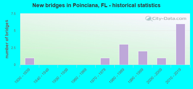
- New bridges - historical statistics
- 11930-1939
- 11970-1979
- 31980-1989
- 21990-1999
- 12000-2009
- 62010-2019
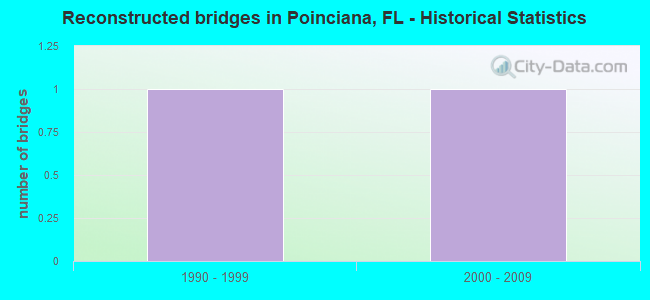
- Reconstructed bridges - Historical Statistics
- 11990-1999
- 12000-2009
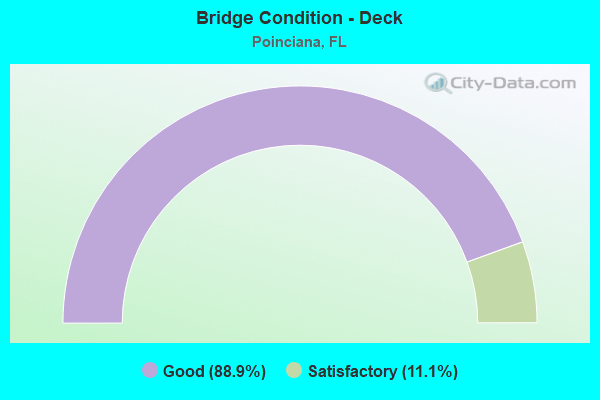
- Bridge Condition - Deck
- 88.9%Good
- 11.1%Satisfactory
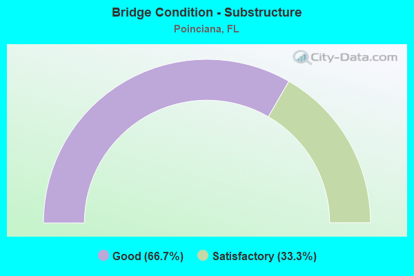
- Bridge Condition - Substructure
- 66.7%Good
- 33.3%Satisfactory
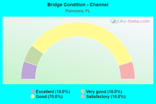
- Bridge Condition - Channel
- 10.0%Excellent
- 10.0%Very good
- 70.0%Good
- 10.0%Satisfactory
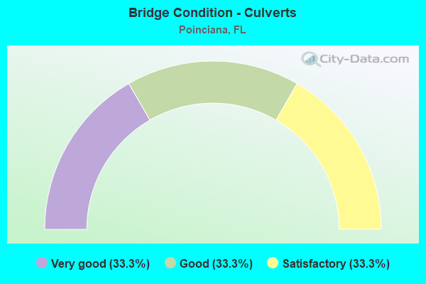
- Bridge Condition - Culverts
- 33.3%Very good
- 33.3%Good
- 33.3%Satisfactory
Find on map >> Show street view
Structure Number: 16422, Location: 1.1MI W OF MARIGOLD AVE. (Lat: 28.069472, Lng: -81.481194), Route carried "on" structure: County highway , Year Built: 1984, Status: Open, Structure Length: 2.74m (8.99ft), Average Daily Traffic: 4,000 (year 2020), Truck Traffic: 8%, Average Future Daily Traffic: 6,940 (year 2042), Design Load: HS 20, Features Intersected: CARTER'S CANAL, Facility Carried by Structure: POINCIANA PARKWAY
Minimum Vertical Clearance: 30+ m (98+ ft), Kilometerpoint: 6.130, Lanes on structure: 2, Owner: County Highway Agency, Approaching Roadway Width: 12.2m (40.0ft), Material/Design: Prestressed concrete, Design/Construction: Slab, Number Of Spans In Main Unit: 3, Length of Maximum Span: 9.1m (29.9ft), Curb-To-Curb Width: 12.2m (40.0ft), Out-to-Out Width: 13.1m (43.0ft)
Condition: Deck: Good, Superstructure: Good, Substructure: Satisfactory, Channel: Good, Operating Rating: 61.7 metric tons, Method Used To Determine Operating Rating: Load Factor (LF), Inventory Rating: 36.3 metric tons, Method Used To Determine Inventory Rating: Load Factor (LF), Structural Evaluation: Equal to present minimum criteria, Deck Geometry: Equal to present minimum criteria, Waterway Adequacy: Better than present minimum criteria, Approach Roadway Alignment: Better than present minimum criteria, Designated Inspection Frequency: Every 24 months, Underwater Inspection Frequency: Every 23 months, Inspection Date: June 2021, Underwater Inspection Date: June 2021, Deck Structure Type: Concrete Precast Panels, Wearing Surface/Protective System: Wearing Surface: Bituminous
Find on map >> Show street view
Structure Number: 164221, Location: 5MI S OF CYPRESS PARKWAY (Lat: 28.092283, Lng: -81.475417), Route carried "on" structure: County highway , Year Built: 1984, Status: Open, Structure Length: 2.74m (8.99ft), Average Daily Traffic: 14,100 (year 2020), Truck Traffic: 4%, Average Future Daily Traffic: 24,464 (year 2042), Design Load: HS 20, Features Intersected: LILY CANAL, Facility Carried by Structure: MARIGOLD AVE.
Minimum Vertical Clearance: 30+ m (98+ ft), Kilometerpoint: 1.415, Lanes on structure: 2, Owner: County Highway Agency, Approaching Roadway Width: 12.2m (40.0ft), Skew: 2 degrees, Material/Design: Prestressed concrete, Design/Construction: Slab, Number Of Spans In Main Unit: 3, Length of Maximum Span: 9.1m (29.9ft), Curb-To-Curb Width: 12.2m (40.0ft), Out-to-Out Width: 13.1m (43.0ft)
Condition: Deck: Good, Superstructure: Good, Substructure: Satisfactory, Channel: Excellent, Operating Rating: 60.8 metric tons, Method Used To Determine Operating Rating: Load Factor (LF), Inventory Rating: 36.3 metric tons, Method Used To Determine Inventory Rating: Load Factor (LF), Structural Evaluation: Equal to present minimum criteria, Deck Geometry: Somewhat better than minimum adequacy, Waterway Adequacy: Better than present minimum criteria, Approach Roadway Alignment: Better than present minimum criteria, Designated Inspection Frequency: Every 24 months, Underwater Inspection Frequency: Every 24 months, Inspection Date: June 2021, Underwater Inspection Date: May 2021, Deck Structure Type: Concrete Precast Panels, Wearing Surface/Protective System: Wearing Surface: Bituminous
Find on map >> Show street view
Structure Number: 164222, Location: 1.1MI W OF MARIGOLD AVE. (Lat: 28.069167, Lng: -81.482211), Route carried "on" structure: County highway , Year Built: 1984, Status: Open, Structure Length: 2.74m (8.99ft), Average Daily Traffic: 4,000 (year 2020), Truck Traffic: 8%, Average Future Daily Traffic: 6,940 (year 2042), Design Load: HS 20, Features Intersected: LAKE MARION CREEK, Facility Carried by Structure: POINCIANA PARKWAY
Minimum Vertical Clearance: 30+ m (98+ ft), Kilometerpoint: 6.014, Lanes on structure: 2, Owner: County Highway Agency, Approaching Roadway Width: 12.2m (40.0ft), Material/Design: Prestressed concrete, Design/Construction: Slab, Number Of Spans In Main Unit: 3, Length of Maximum Span: 9.1m (29.9ft), Curb-To-Curb Width: 12.2m (40.0ft), Out-to-Out Width: 13.1m (43.0ft)
Condition: Deck: Good, Superstructure: Good, Substructure: Satisfactory, Channel: Good, Operating Rating: 61.7 metric tons, Method Used To Determine Operating Rating: Load Factor (LF), Inventory Rating: 36.3 metric tons, Method Used To Determine Inventory Rating: Load Factor (LF), Structural Evaluation: Equal to present minimum criteria, Deck Geometry: Equal to present minimum criteria, Waterway Adequacy: Better than present minimum criteria, Approach Roadway Alignment: Better than present minimum criteria, Designated Inspection Frequency: Every 24 months, Inspection Date: June 2021, Deck Structure Type: Concrete Precast Panels, Wearing Surface/Protective System: Wearing Surface: Bituminous
Find on map >> Show street view
Structure Number: 164542, Location: 0.5MI E OF MARIGOLD AVE. (Lat: 28.128408, Lng: -81.463622), Route carried "on" structure: City street , Year Built: 1970, Status: Open, Structure Length: 0.64m (2.10ft), Average Daily Traffic: 4,500 (year 2020), Truck Traffic: 4%, Average Future Daily Traffic: 7,808 (year 2042), Features Intersected: FAIRWAY DITCH, Facility Carried by Structure: WALNUT ST.
Minimum Vertical Clearance: 30.45m (99.90ft), Kilometerpoint: 0.771, Lanes on structure: 2, Owner: County Highway Agency, Approaching Roadway Width: 7.2m (23.6ft), Skew: 3 degrees, Material/Design: Concrete, Design/Construction: Culvert, Number Of Spans In Main Unit: 2, Length of Maximum Span: 3.1m (10.2ft)
Condition: Channel: Good, Culverts: Satisfactory, Operating Rating: 84.5 metric tons, Method Used To Determine Operating Rating: Load Factor (LF), Inventory Rating: 50.7 metric tons, Method Used To Determine Inventory Rating: Load Factor (LF), Structural Evaluation: Equal to present minimum criteria, Waterway Adequacy: Better than present minimum criteria, Approach Roadway Alignment: Better than present minimum criteria, Designated Inspection Frequency: Every 24 months, Inspection Date: June 2021
Find on map >> Show street view
Structure Number: 920001, Location: .3 Mi E of Polk Co.Line (Lat: 28.253194, Lng: -81.548306), Route carried "on" structure: US 600, Year Built: 1934, Year Reconstructed: 1996, Status: Open, Structure Length: 0.79m (2.59ft), Average Daily Traffic: 15,800 (year 2020), Truck Traffic: 11%, Average Future Daily Traffic: 27,413 (year 2042), Design Load: H 15, Features Intersected: Reedy Creek, Facility Carried by Structure: US-92
Minimum Vertical Clearance: 30+ m (98+ ft), Kilometerpoint: 0.568, Lanes on structure: 2, Base Highway Network: Yes, Owner: State Highway Agency, Approaching Roadway Width: 9.8m (32.2ft), Material/Design: Concrete, Design/Construction: Culvert, Number Of Spans In Main Unit: 3, Length of Maximum Span: 2.4m (7.9ft)
Condition: Channel: Satisfactory, Culverts: Good, Operating Rating: 47.4 metric tons, Method Used To Determine Operating Rating: Load Testing, Inventory Rating: 27.7 metric tons, Method Used To Determine Inventory Rating: Load Testing, Structural Evaluation: Equal to present minimum criteria, Waterway Adequacy: Equal to present desirable criteria, Approach Roadway Alignment: Equal to present desirable criteria, Designated Inspection Frequency: Every 24 months, Inspection Date: October 2021
Find on map >> Show street view
Structure Number: 920174, Location: US-17-92 - Reedy Creek (Lat: 28.262119, Lng: -81.539189), Route carried "on" structure: US 600, Year Built: 2001, Status: Open, Structure Length: 68.07m (223.33ft), Average Daily Traffic: 25,000 (year 2020), Truck Traffic: 10%, Average Future Daily Traffic: 43,375 (year 2042), Design Load: HS 20+Mod, Features Intersected: Reedy Creek, Facility Carried by Structure: US-17-92
Minimum Vertical Clearance: 30.45m (99.90ft), Kilometerpoint: 0.727, Lanes on structure: 2, Base Highway Network: Yes, Owner: State Highway Agency, Approaching Roadway Width: 13.9m (45.6ft), Material/Design: Prestressed concrete, Design/Construction: Stringer/Multi-beam, Number Of Spans In Main Unit: 30, Length of Maximum Span: 22.7m (74.5ft), Curb-To-Curb Width: 13.1m (43.0ft), Out-to-Out Width: 14.1m (46.3ft)
Condition: Deck: Good, Superstructure: Good, Substructure: Good, Channel: Good, Operating Rating: 66.9 metric tons, Method Used To Determine Operating Rating: Load Factor (LF), Inventory Rating: 41.7 metric tons, Method Used To Determine Inventory Rating: Load Factor (LF), Structural Evaluation: Better than present minimum criteria, Deck Geometry: Somewhat better than minimum adequacy, Waterway Adequacy: Equal to present desirable criteria, Approach Roadway Alignment: Equal to present desirable criteria, Designated Inspection Frequency: Every 24 months, Underwater Inspection Frequency: Every 24 months, Inspection Date: July 2021, Underwater Inspection Date: July 2021, Deck Structure Type: Concrete Cast-file-Place, Wearing Surface/Protective System: Wearing Surface: Monolithic Concrete
Find on map >> Show street view
Structure Number: 920206, Location: 4.75 Miles N of CR-580 (Lat: 28.225750, Lng: -81.532000), Route carried "on" structure: Other road , Year Built: 2015, Status: Open, Structure Length: 188.03m (616.90ft), Average Daily Traffic: 501 (year 2020), Truck Traffic: 10%, Average Future Daily Traffic: 1,001 (year 2042), Design Load: HL 93, Features Intersected: Reedy Creek, Facility Carried by Structure: Poinciana Parkway
Minimum Vertical Clearance: 30+ m (98+ ft), Kilometerpoint: 8.946, Lanes on structure: 2, Toll: On toll road, Owner: State Toll Authority, Approaching Roadway Width: 13.4m (44.0ft), Material/Design: Prestressed concrete, Design/Construction: Stringer/Multi-beam, Number Of Spans In Main Unit: 62, Length of Maximum Span: 30.3m (99.4ft), Curb-To-Curb Width: 13.4m (44.0ft), Out-to-Out Width: 14.3m (46.9ft)
Condition: Deck: Satisfactory, Superstructure: Good, Substructure: Good, Channel: Good, Operating Rating: 41.8 metric tons, Method Used To Determine Operating Rating: Load and Resistance Factor (LRFR), Inventory Rating: 37.9 metric tons, Method Used To Determine Inventory Rating: Load and Resistance Factor (LRFR), Structural Evaluation: Better than present minimum criteria, Deck Geometry: Superior to present desirable criteria, Waterway Adequacy: Equal to present desirable criteria, Approach Roadway Alignment: Equal to present desirable criteria, Designated Inspection Frequency: Every 24 months, Inspection Date: September 2020, Deck Structure Type: Concrete Cast-file-Place
Find on map >> Show street view
Structure Number: 920207, Location: 3.1 Miles N of CR 580 (Lat: 28.189047, Lng: -81.504528), Route carried "on" structure: Other road , Year Built: 2015, Status: Open, Structure Length: 4.36m (14.30ft), Average Daily Traffic: 501 (year 2018), Truck Traffic: 10%, Average Future Daily Traffic: 1,001 (year 2035), Design Load: HL 93, Features Intersected: Marigold Avenue, Facility Carried by Structure: Poinciana Pkwy
Minimum Vertical Clearance: 30+ m (98+ ft), Kilometerpoint: 1.357, Lanes on structure: 2, Lanes under structure: 2, Toll: On toll road, Owner: State Toll Authority, Approaching Roadway Width: 15.2m (49.9ft), Skew: 1 degrees, Material/Design: Prestressed concrete, Design/Construction: Stringer/Multi-beam, Number Of Spans In Main Unit: 1, Length of Maximum Span: 43.6m (143.0ft), Curb-To-Curb Width: 13.4m (44.0ft), Out-to-Out Width: 14.3m (46.9ft)
Condition: Deck: Good, Superstructure: Good, Substructure: Good, Operating Rating: 43.5 metric tons, Method Used To Determine Operating Rating: Load and Resistance Factor (LRFR), Inventory Rating: 39.2 metric tons, Method Used To Determine Inventory Rating: Load and Resistance Factor (LRFR), Structural Evaluation: Better than present minimum criteria, Deck Geometry: Superior to present desirable criteria, Underclear: Superior to present desirable criteria, Approach Roadway Alignment: Equal to present desirable criteria, Designated Inspection Frequency: Every 24 months, Inspection Date: September 2020, Deck Structure Type: Concrete Cast-file-Place, Wearing Surface/Protective System: Wearing Surface: Monolithic Concrete
Find on map >> Show street view
Structure Number: 920208, Location: 0.8 Mile N of CR 580 (Lat: 28.154342, Lng: -81.502794), Route carried "on" structure: Other road , Year Built: 2015, Status: Open, Structure Length: 2.90m (9.51ft), Average Daily Traffic: 501 (year 2020), Truck Traffic: 10%, Average Future Daily Traffic: 1,001 (year 2042), Design Load: HL 93, Features Intersected: KOA Street, Facility Carried by Structure: Poinciana Parkway
Minimum Vertical Clearance: 30+ m (98+ ft), Kilometerpoint: 5.201, Lanes on structure: 2, Lanes under structure: 2, Toll: On toll road, Owner: State Toll Authority, Approaching Roadway Width: 15.2m (49.9ft), Material/Design: Prestressed concrete, Design/Construction: Stringer/Multi-beam, Number Of Spans In Main Unit: 1, Length of Maximum Span: 29.0m (95.1ft), Curb-To-Curb Width: 13.4m (44.0ft), Out-to-Out Width: 14.3m (46.9ft)
Condition: Deck: Good, Superstructure: Good, Substructure: Good, Operating Rating: 53.3 metric tons, Method Used To Determine Operating Rating: Load and Resistance Factor (LRFR), Inventory Rating: 41.8 metric tons, Method Used To Determine Inventory Rating: Load and Resistance Factor (LRFR), Structural Evaluation: Better than present minimum criteria, Deck Geometry: Superior to present desirable criteria, Underclear: Superior to present desirable criteria, Approach Roadway Alignment: Equal to present desirable criteria, Designated Inspection Frequency: Every 24 months, Inspection Date: September 2020, Deck Structure Type: Concrete Cast-file-Place
Find on map >> Show street view
Structure Number: 920209, Location: 1.8 Miles N of CR 580 (Lat: 28.168625, Lng: -81.503758), Route carried "on" structure: Other road , Year Built: 2015, Status: Open, Structure Length: 0.63m (2.07ft), Average Daily Traffic: 501 (year 2018), Truck Traffic: 10%, Average Future Daily Traffic: 1,001 (year 2035), Design Load: HL 93, Features Intersected: Canal, Facility Carried by Structure: Poinciana Parkway
Minimum Vertical Clearance: 30+ m (98+ ft), Kilometerpoint: 2.953, Lanes on structure: 2, Toll: On toll road, Owner: State Toll Authority, Approaching Roadway Width: 14.0m (45.9ft), Material/Design: Concrete, Design/Construction: Culvert, Number Of Spans In Main Unit: 2, Length of Maximum Span: 3.2m (10.5ft)
Condition: Channel: Very good, Culverts: Very good, Operating Rating: 83.9 metric tons, Method Used To Determine Operating Rating: Load and Resistance Factor (LRFR), Inventory Rating: 64.7 metric tons, Method Used To Determine Inventory Rating: Load and Resistance Factor (LRFR), Structural Evaluation: Equal to present desirable criteria, Waterway Adequacy: Better than present minimum criteria, Approach Roadway Alignment: Equal to present desirable criteria, Designated Inspection Frequency: Every 24 months, Underwater Inspection Frequency: Every 24 months, Inspection Date: September 2020, Underwater Inspection Date: September 2020
Find on map >> Show street view
Structure Number: 924152, Location: 0.3mi S of Poinciana Blvd (Lat: 28.150456, Lng: -81.441361), Route carried "on" structure: County highway 531, Year Built: 1991, Year Reconstructed: 2000, Status: Open, Structure Length: 5.36m (17.59ft), Average Daily Traffic: 51,500 (year 2020), Truck Traffic: 5%, Average Future Daily Traffic: 89,353 (year 2042), Design Load: HS 20, Features Intersected: Reedy Creek, Facility Carried by Structure: Pleasant Hill SB
Minimum Vertical Clearance: 30+ m (98+ ft), Kilometerpoint: 1.954, Lanes on structure: 3, Base Highway Network: Yes, Owner: County Highway Agency, Approaching Roadway Width: 11.2m (36.7ft), Material/Design: Concrete continuous, Design/Construction: Slab, Number Of Spans In Main Unit: 7, Length of Maximum Span: 7.8m (25.6ft), Curb-To-Curb Width: 14.8m (48.6ft), Out-to-Out Width: 15.7m (51.5ft)
Condition: Deck: Good, Superstructure: Good, Substructure: Good, Channel: Good, Operating Rating: 60.1 metric tons, Method Used To Determine Operating Rating: Load Factor (LF), Inventory Rating: 36.0 metric tons, Method Used To Determine Inventory Rating: Load Factor (LF), Structural Evaluation: Better than present minimum criteria, Deck Geometry: Equal to present minimum criteria, Waterway Adequacy: Equal to present desirable criteria, Approach Roadway Alignment: Equal to present desirable criteria, Designated Inspection Frequency: Every 24 months, Underwater Inspection Frequency: Every 24 months, Inspection Date: July 2020, Underwater Inspection Date: July 2020, Deck Structure Type: Concrete Cast-file-Place
Find on map >> Show street view
Structure Number: 924176, Location: 0.3Mi S of Poinciana Blvd (Lat: 28.150353, Lng: -81.441303), Route carried "on" structure: County highway 531, Year Built: 1999, Status: Open, Structure Length: 5.36m (17.59ft), Average Daily Traffic: 51,500 (year 2020), Truck Traffic: 5%, Average Future Daily Traffic: 89,353 (year 2042), Design Load: HS 20, Features Intersected: Reedy Creek, Facility Carried by Structure: Pleasant Hill NB
Minimum Vertical Clearance: 30+ m (98+ ft), Kilometerpoint: 1.954, Lanes on structure: 3, Base Highway Network: Yes, Owner: County Highway Agency, Approaching Roadway Width: 11.6m (38.1ft), Material/Design: Concrete continuous, Design/Construction: Slab, Number Of Spans In Main Unit: 7, Length of Maximum Span: 7.8m (25.6ft), Curb or Sidewalk Widths: Left: 0.0m, Right: 2.5m (8.2ft), Curb-To-Curb Width: 12.5m (41.0ft), Out-to-Out Width: 16.3m (53.5ft)
Condition: Deck: Good, Superstructure: Good, Substructure: Good, Channel: Good, Operating Rating: 59.9 metric tons, Method Used To Determine Operating Rating: Load Factor (LF), Inventory Rating: 36.3 metric tons, Method Used To Determine Inventory Rating: Load Factor (LF), Structural Evaluation: Better than present minimum criteria, Deck Geometry: Meets minimum limits, Waterway Adequacy: Equal to present desirable criteria, Approach Roadway Alignment: Equal to present desirable criteria, Designated Inspection Frequency: Every 24 months, Underwater Inspection Frequency: Every 24 months, Inspection Date: July 2020, Underwater Inspection Date: July 2020, Deck Structure Type: Concrete Cast-file-Place
Find on map >> Show street view
Structure Number: 920207, Location: 3.1 Miles N of CR 580 (Lat: 28.189047, Lng: -81.504528), Route carried "under" structure: City street , Year Built: 2015, Structure Length: 0. m, Average Daily Traffic: 200 (year 2016), Truck Traffic: 2%, Features Intersected: Marigold Avenue, Facility Carried by Structure: Poinciana Pkwy
Minimum Vertical Clearance: 5.46m (17.91ft), Kilometerpoint: 1.287, Lanes on structure: 2, Lanes under structure: 2, Material/Design: Prestressed concrete, Design/Construction: Stringer/Multi-beam, Length of Maximum Span: 43.6m (143.0ft)
Find on map >> Show street view
Structure Number: 920208, Location: 0.8 Mile N of CR 580 (Lat: 28.154342, Lng: -81.502794), Route carried "under" structure: County highway , Year Built: 2015, Structure Length: 0. m, Average Daily Traffic: 201 (year 2018), Truck Traffic: 2%, Features Intersected: KOA Street, Facility Carried by Structure: Poinciana Parkway
Minimum Vertical Clearance: 5.09m (16.70ft), Kilometerpoint: 5.150, Lanes on structure: 2, Lanes under structure: 2, Material/Design: Prestressed concrete, Design/Construction: Stringer/Multi-beam, Length of Maximum Span: 29.0m (95.1ft)