Bridge Statistics for Pomfret, New York (NY)
Condition, Traffic, Stress, Structural Evaluation, Project Costs
- National Bridge Inventory (NBI) Statistics
- 31Number of bridges
- 246ft / 75.5mTotal length
- $54,613,000Total costs
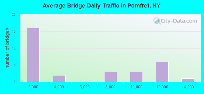
- 138,762Total average daily traffic
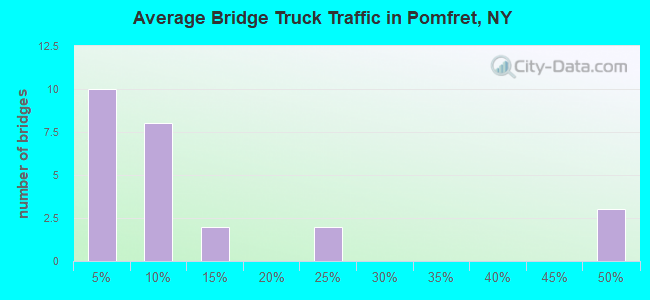
- 20,458Total average daily truck traffic
- National Bridge Inventory (NBI) Registered Bridges for Pomfret
- No street view available for this location
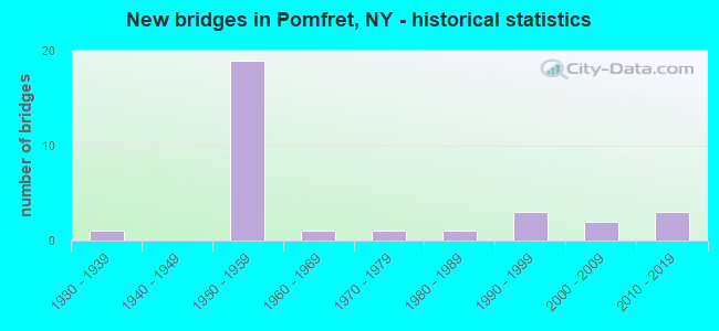
- New bridges - historical statistics
- 11930-1939
- 191950-1959
- 11960-1969
- 11970-1979
- 11980-1989
- 31990-1999
- 22000-2009
- 32010-2019
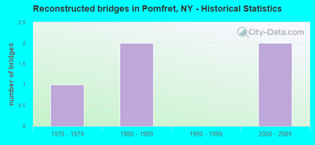
- Reconstructed bridges - Historical Statistics
- 11970-1979
- 21980-1989
- 01990-1999
- 22000-2009
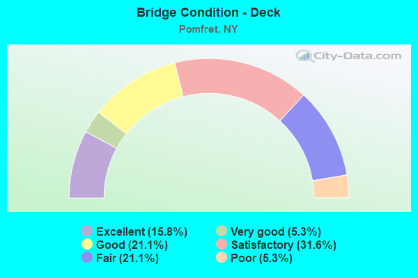
- Bridge Condition - Deck
- 15.8%Excellent
- 5.3%Very good
- 21.1%Good
- 31.6%Satisfactory
- 21.1%Fair
- 5.3%Poor
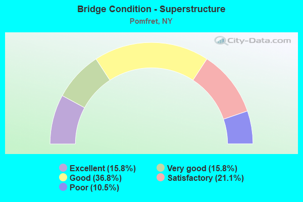
- Bridge Condition - Superstructure
- 15.8%Excellent
- 15.8%Very good
- 36.8%Good
- 21.1%Satisfactory
- 10.5%Poor
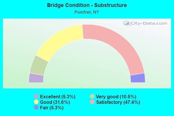
- Bridge Condition - Substructure
- 5.3%Excellent
- 10.5%Very good
- 31.6%Good
- 47.4%Satisfactory
- 5.3%Fair
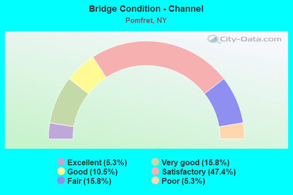
- Bridge Condition - Channel
- 5.3%Excellent
- 15.8%Very good
- 10.5%Good
- 47.4%Satisfactory
- 15.8%Fair
- 5.3%Poor
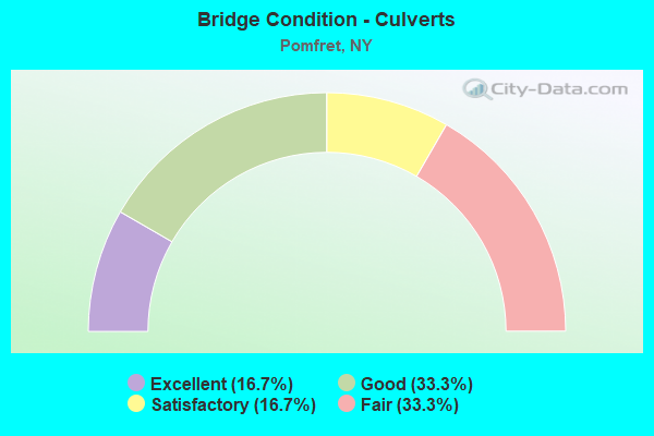
- Bridge Condition - Culverts
- 16.7%Excellent
- 33.3%Good
- 16.7%Satisfactory
- 33.3%Fair
Find on map >> Show street view
Structure Number: 101539, Location: 2.8 MI NE OF BROCTON (Lat: 42.411589, Lng: -79.396006), Route carried "on" structure: US 20, Year Built: 2004, Status: Open, Structure Length: 0.79m (2.59ft), Average Daily Traffic: 3,500 (year 2019), Truck Traffic: 6%, Average Future Daily Traffic: 3,533 (year 2040), Design Load: HS 25 or greater, Features Intersected: LIT CANADAWAY CRK
Minimum Vertical Clearance: 30+ m (98+ ft), Kilometerpoint: 35.816, Lanes on structure: 2, Base Highway Network: Yes, Owner: State Highway Agency, Approaching Roadway Width: 12.2m (40.0ft), Material/Design: Concrete, Design/Construction: Culvert, Number Of Spans In Main Unit: 1, Length of Maximum Span: 7.6m (24.9ft), Curb-To-Curb Width: 12.0m (39.4ft), Out-to-Out Width: 13.0m (42.7ft)
Condition: Channel: Very good, Culverts: Excellent, Inventory Rating: 62.6 metric tons, Method Used To Determine Inventory Rating: Load Factor (LF), Structural Evaluation: Superior to present desirable criteria, Deck Geometry: Somewhat better than minimum adequacy, Waterway Adequacy: Equal to present minimum criteria, Approach Roadway Alignment: Equal to present desirable criteria, Length Of Structure Improvement: 0.79m (2.59ft), Designated Inspection Frequency: Every 24 months, Inspection Date: June 2020, Bridge Improvement Cost: $658,000, Roadway Improvement Cost: $385,000, Total Project Cost: $1,043,000 ( Estimate for 2021), Wearing Surface/Protective System: Wearing Surface: Bituminous, Membrane: Other
Find on map >> Show street view
Structure Number: 102787, Location: 1.2MI S JCT RTS 60 & 83 (Lat: 42.397347, Lng: -79.303908), Route carried "on" structure: State highway 60, Year Built: 1993, Status: Open, Structure Length: 5.03m (16.50ft), Average Daily Traffic: 7,055 (year 2020), Truck Traffic: 14%, Average Future Daily Traffic: 7,122 (year 2040), Design Load: HS 20, Features Intersected: CANADAWAY CREEK
Minimum Vertical Clearance: 30+ m (98+ ft), Kilometerpoint: 42.799, Lanes on structure: 2, Base Highway Network: Yes, Owner: State Highway Agency, Approaching Roadway Width: 14.6m (47.9ft), Material/Design: Steel, Design/Construction: Stringer/Multi-beam, Number Of Spans In Main Unit: 1, Length of Maximum Span: 49.6m (162.7ft), Curb-To-Curb Width: 14.6m (47.9ft), Out-to-Out Width: 15.2m (49.9ft)
Condition: Deck: Very good, Superstructure: Very good, Substructure: Good, Channel: Good, Operating Rating: 88.0 metric tons, Method Used To Determine Operating Rating: Load Factor (LF), Inventory Rating: 40.8 metric tons, Method Used To Determine Inventory Rating: Load Factor (LF), Structural Evaluation: Better than present minimum criteria, Deck Geometry: Superior to present desirable criteria, Waterway Adequacy: Somewhat better than minimum adequacy, Approach Roadway Alignment: Equal to present desirable criteria, Length Of Structure Improvement: 5.02m (16.47ft), Designated Inspection Frequency: Every 24 months, Inspection Date: June 2021, Bridge Improvement Cost: $3,093,000, Roadway Improvement Cost: $1,811,000, Total Project Cost: $4,905,000 ( Estimate for 2021), Deck Structure Type: Concrete Cast-file-Place, Wearing Surface/Protective System: Wearing Surface: Integral Concrete, Deck Protection: Epoxy Coated Reinforcing
Find on map >> Show street view
Structure Number: 102788, Location: JCT SH 60 & SH 83 (Lat: 42.414719, Lng: -79.304672), Route carried "on" structure: State highway 60, Year Built: 1931, Status: Open, Structure Length: 0.82m (2.69ft), Average Daily Traffic: 8,914 (year 2018), Truck Traffic: 12%, Average Future Daily Traffic: 8,955 (year 2040), Features Intersected: DUTCH HOLLW CREEK
Minimum Vertical Clearance: 30+ m (98+ ft), Kilometerpoint: 44.762, Lanes on structure: 2, Base Highway Network: Yes, Owner: State Highway Agency, Approaching Roadway Width: 12.2m (40.0ft), Skew: 2 degrees, Material/Design: Concrete, Design/Construction: Slab, Number Of Spans In Main Unit: 1, Length of Maximum Span: 7.9m (25.9ft), Curb or Sidewalk Widths: Left: 0.0m, Right: 1.4m (4.6ft), Curb-To-Curb Width: 10.7m (35.1ft), Out-to-Out Width: 12.8m (42.0ft)
Condition: Deck: Satisfactory, Superstructure: Satisfactory, Substructure: Satisfactory, Channel: Good, Operating Rating: 81.6 metric tons, Method Used To Determine Operating Rating: Load Factor (LF), Inventory Rating: 49.0 metric tons, Method Used To Determine Inventory Rating: Load Factor (LF), Structural Evaluation: Equal to present minimum criteria, Deck Geometry: Meets minimum limits, Waterway Adequacy: Somewhat better than minimum adequacy, Approach Roadway Alignment: Somewhat better than minimum adequacy, Length Of Structure Improvement: 0.82m (2.69ft), Designated Inspection Frequency: Every 24 months, Inspection Date: June 2021, Bridge Improvement Cost: $527,000, Roadway Improvement Cost: $309,000, Total Project Cost: $836,000 ( Estimate for 2021), Wearing Surface/Protective System: Wearing Surface: Bituminous, Membrane: Other
Find on map >> Show street view
Structure Number: 22127, Location: 1 MI S OF LAMBERTON (Lat: 42.396131, Lng: -79.394372), Route carried "on" structure: Other road , Year Built: 1990, Status: Open, Structure Length: 1.31m (4.30ft), Average Daily Traffic: 464 (year 2020), Truck Traffic: 6%, Average Future Daily Traffic: 650 (year 2040), Design Load: HS 20, Features Intersected: LIT CANADAWAY CRK, Facility Carried by Structure: ELLICOTT ROAD
Minimum Vertical Clearance: 30+ m (98+ ft), Kilometerpoint: 1.963, Lanes on structure: 2, Owner: County Highway Agency, Approaching Roadway Width: 6.7m (22.0ft), Material/Design: Steel, Design/Construction: Stringer/Multi-beam, Number Of Spans In Main Unit: 1, Length of Maximum Span: 12.8m (42.0ft), Curb-To-Curb Width: 7.3m (24.0ft), Out-to-Out Width: 7.9m (25.9ft)
Condition: Deck: Satisfactory, Superstructure: Good, Substructure: Good, Channel: Fair, Operating Rating: 37.9 metric tons, Method Used To Determine Operating Rating: Load and Resistance Factor Rating (LRFR) rating reported by rating factor(RF) method using HL-93 loadings, Inventory Rating: 29.2 metric tons, Method Used To Determine Inventory Rating: Load and Resistance Factor Rating (LRFR) rating reported by rating factor(RF) method using HL-93 loadings, Structural Evaluation: Better than present minimum criteria, Deck Geometry: Meets minimum limits, Waterway Adequacy: Meets minimum limits, Approach Roadway Alignment: Equal to present minimum criteria, Length Of Structure Improvement: 1.31m (4.30ft), Designated Inspection Frequency: Every 24 months, Inspection Date: April 2021, Bridge Improvement Cost: $458,000, Roadway Improvement Cost: $268,000, Total Project Cost: $727,000 ( Estimate for 2021), Deck Structure Type: Wood or Timber, Wearing Surface/Protective System: Wearing Surface: Bituminous
Find on map >> Show street view
Structure Number: 221271, Location: 1.5 MI N OF CASSADAGA (Lat: 42.371581, Lng: -79.324750), Route carried "on" structure: Other road , Year Built: 1970, Status: Open, Structure Length: 0.70m (2.30ft), Average Daily Traffic: 586 (year 2016), Truck Traffic: 2%, Average Future Daily Traffic: 820 (year 2036), Features Intersected: FREDONIA RES TRIB, Facility Carried by Structure: GLASGOW ROAD
Minimum Vertical Clearance: 30+ m (98+ ft), Kilometerpoint: 1.786, Lanes on structure: 2, Owner: County Highway Agency, Approaching Roadway Width: 5.5m (18.0ft), Material/Design: Steel, Design/Construction: Culvert, Number Of Spans In Main Unit: 2, Length of Maximum Span: 3.3m (10.8ft)
Condition: Channel: Fair, Culverts: Good, Operating Rating: 74.9 metric tons, Method Used To Determine Operating Rating: Field evaluation and documented engineering judgment, Inventory Rating: 32.7 metric tons, Method Used To Determine Inventory Rating: Field evaluation and documented engineering judgment, Structural Evaluation: Better than present minimum criteria, Waterway Adequacy: Meets minimum limits, Approach Roadway Alignment: Meets minimum limits, Length Of Structure Improvement: 0.70m (2.30ft), Designated Inspection Frequency: Every 24 months, Inspection Date: March 2021, Bridge Improvement Cost: $106,000, Roadway Improvement Cost: $62,000, Total Project Cost: $168,000 ( Estimate for 2021)
Find on map >> Show street view
Structure Number: 221272, Location: 1.0 MI N OF LAMBERTON (Lat: 42.424358, Lng: -79.402072), Route carried "on" structure: Other road , Year Built: 1955, Status: Open, Structure Length: 1.37m (4.49ft), Average Daily Traffic: 109 (year 2016), Truck Traffic: 5%, Average Future Daily Traffic: 153 (year 2036), Design Load: HS 20, Features Intersected: LIT CANADAWAY CRK, Facility Carried by Structure: LOWELL ROAD
Minimum Vertical Clearance: 30+ m (98+ ft), Kilometerpoint: 0.788, Lanes on structure: 2, Owner: County Highway Agency, Approaching Roadway Width: 5.5m (18.0ft), Skew: 1 degrees, Material/Design: Concrete continuous, Design/Construction: Culvert, Number Of Spans In Main Unit: 2, Length of Maximum Span: 5.5m (18.0ft)
Condition: Channel: Fair, Culverts: Good, Operating Rating: 76.0 metric tons, Method Used To Determine Operating Rating: Field evaluation and documented engineering judgment, Inventory Rating: 29.4 metric tons, Method Used To Determine Inventory Rating: Field evaluation and documented engineering judgment, Structural Evaluation: Better than present minimum criteria, Waterway Adequacy: Somewhat better than minimum adequacy, Approach Roadway Alignment: Equal to present desirable criteria, Length Of Structure Improvement: 1.37m (4.49ft), Designated Inspection Frequency: Every 24 months, Inspection Date: March 2021, Bridge Improvement Cost: $439,000, Roadway Improvement Cost: $257,000, Total Project Cost: $695,000 ( Estimate for 2021)
Find on map >> Show street view
Structure Number: 221273, Location: 2.2 MI S OF LEONA (Lat: 42.386336, Lng: -79.298569), Route carried "on" structure: Other road , Year Built: 1960, Year Reconstructed: 1981, Status: Posted for load-capacity, Structure Length: 1.25m (4.10ft), Average Daily Traffic: 232 (year 2018), Truck Traffic: 6%, Average Future Daily Traffic: 325 (year 2038), Design Load: HS 20, Features Intersected: CANADAWAY CREEK, Facility Carried by Structure: SHUMLA ROAD
Minimum Vertical Clearance: 30+ m (98+ ft), Kilometerpoint: 1.625, Lanes on structure: 2, Owner: County Highway Agency, Approaching Roadway Width: 5.2m (17.1ft), Material/Design: Steel, Design/Construction: Stringer/Multi-beam, Number Of Spans In Main Unit: 1, Length of Maximum Span: 12.1m (39.7ft), Curb-To-Curb Width: 7.5m (24.6ft), Out-to-Out Width: 7.9m (25.9ft)
Condition: Deck: Satisfactory, Superstructure: Poor, Substructure: Satisfactory, Channel: Satisfactory, Operating Rating: 22.0 metric tons, Method Used To Determine Operating Rating: Load and Resistance Factor Rating (LRFR) rating reported by rating factor(RF) method using HL-93 loadings, Inventory Rating: 17.2 metric tons, Method Used To Determine Inventory Rating: Load and Resistance Factor Rating (LRFR) rating reported by rating factor(RF) method using HL-93 loadings, Structural Evaluation: Meets minimum limits, Deck Geometry: Somewhat better than minimum adequacy, Waterway Adequacy: Meets minimum limits, Approach Roadway Alignment: High priority of corrective action, Length Of Structure Improvement: 1.24m (4.07ft), Designated Inspection Frequency: Every 24 months, Inspection Date: October 2021, Bridge Improvement Cost: $787,000, Roadway Improvement Cost: $461,000, Total Project Cost: $1,247,000 ( Estimate for 2021), Deck Structure Type: Concrete Precast Panels, Wearing Surface/Protective System: Wearing Surface: Bituminous
Find on map >> Show street view
Structure Number: 226774, Location: 2 MILES SW OF FREDONIA (Lat: 42.400250, Lng: -79.358964), Route carried "on" structure: Other road , Year Built: 2016, Status: Open, Structure Length: 0.99m (3.25ft), Average Daily Traffic: 360 (year 2020), Truck Traffic: 3%, Average Future Daily Traffic: 504 (year 2040), Design Load: HS 25 or greater, Features Intersected: LIT CANADAWAY CRK, Facility Carried by Structure: CHAUTAUQUA ROAD
Minimum Vertical Clearance: 30+ m (98+ ft), Kilometerpoint: 7.337, Lanes on structure: 2, Owner: County Highway Agency, Approaching Roadway Width: 6.4m (21.0ft), Material/Design: Concrete, Design/Construction: Frame, Number Of Spans In Main Unit: 1, Length of Maximum Span: 9.6m (31.5ft), Curb-To-Curb Width: 9.0m (29.5ft), Out-to-Out Width: 9.9m (32.5ft)
Condition: Deck: Excellent, Superstructure: Excellent, Substructure: Very good, Channel: Poor, Operating Rating: 79.8 metric tons, Method Used To Determine Operating Rating: Load Factor (LF), Inventory Rating: 47.2 metric tons, Method Used To Determine Inventory Rating: Load Factor (LF), Structural Evaluation: Equal to present desirable criteria, Deck Geometry: Equal to present minimum criteria, Waterway Adequacy: Meets minimum limits, Approach Roadway Alignment: Equal to present desirable criteria, Length Of Structure Improvement: 0.99m (3.25ft), Designated Inspection Frequency: Every 24 months, Inspection Date: June 2020, Bridge Improvement Cost: $405,000, Roadway Improvement Cost: $237,000, Total Project Cost: $641,000 ( Estimate for 2021), Wearing Surface/Protective System: Wearing Surface: Bituminous, Membrane: Other
Find on map >> Show street view
Structure Number: 332539, Location: 2.1 MI N OF CASSADAGA (Lat: 42.379053, Lng: -79.314231), Route carried "on" structure: Other road , Year Built: 1985, Status: Open, Structure Length: 1.04m (3.41ft), Average Daily Traffic: 152 (year 2017), Truck Traffic: 4%, Average Future Daily Traffic: 213 (year 2037), Features Intersected: TRB FREDONIA RESV, Facility Carried by Structure: DARBY SWITCH ROAD
Minimum Vertical Clearance: 30+ m (98+ ft), Kilometerpoint: 0.805, Lanes on structure: 2, Owner: County Highway Agency, Approaching Roadway Width: 5.5m (18.0ft), Skew: 3 degrees, Material/Design: Steel, Design/Construction: Stringer/Multi-beam, Number Of Spans In Main Unit: 1, Length of Maximum Span: 10.0m (32.8ft), Curb-To-Curb Width: 6.0m (19.7ft), Out-to-Out Width: 6.5m (21.3ft)
Condition: Deck: Good, Superstructure: Good, Substructure: Satisfactory, Channel: Satisfactory, Operating Rating: 52.6 metric tons, Method Used To Determine Operating Rating: Load Factor (LF), Inventory Rating: 31.8 metric tons, Method Used To Determine Inventory Rating: Load Factor (LF), Structural Evaluation: Equal to present minimum criteria, Deck Geometry: High priority of corrective action, Waterway Adequacy: Equal to present desirable criteria, Approach Roadway Alignment: Meets minimum limits, Length Of Structure Improvement: 1.03m (3.38ft), Designated Inspection Frequency: Every 24 months, Inspection Date: April 2020, Bridge Improvement Cost: $1,064,000, Roadway Improvement Cost: $623,000, Total Project Cost: $1,687,000 ( Estimate for 2021), Deck Structure Type: Wood or Timber, Wearing Surface/Protective System: Wearing Surface: Bituminous
Find on map >> Show street view
Structure Number: 33254, Location: .2 MILE WEST OF LAONA (Lat: 42.420756, Lng: -79.309942), Route carried "on" structure: County highway , Year Built: 2012, Status: Open, Structure Length: 2.41m (7.91ft), Average Daily Traffic: 3,300 (year 2020), Truck Traffic: 7%, Average Future Daily Traffic: 4,083 (year 2040), Design Load: HL 93, Features Intersected: CANADAWAY CREEK, Facility Carried by Structure: WEBSTER ROAD
Minimum Vertical Clearance: 30+ m (98+ ft), Kilometerpoint: 0.129, Lanes on structure: 2, Owner: County Highway Agency, Approaching Roadway Width: 9.1m (29.9ft), Skew: 1 degrees, Material/Design: Prestressed concrete, Design/Construction: Box Beam or Girders - Multiple, Number Of Spans In Main Unit: 1, Length of Maximum Span: 22.9m (75.1ft), Curb-To-Curb Width: 9.1m (29.9ft), Out-to-Out Width: 10.2m (33.5ft)
Condition: Deck: Excellent, Superstructure: Excellent, Substructure: Excellent, Channel: Very good, Operating Rating: 97.2 metric tons, Method Used To Determine Operating Rating: Load and Resistance Factor Rating (LRFR) rating reported by rating factor(RF) method using HL-93 loadings, Inventory Rating: 75.2 metric tons, Method Used To Determine Inventory Rating: Load and Resistance Factor Rating (LRFR) rating reported by rating factor(RF) method using HL-93 loadings, Structural Evaluation: Superior to present desirable criteria, Deck Geometry: Meets minimum limits, Waterway Adequacy: Equal to present minimum criteria, Approach Roadway Alignment: Equal to present desirable criteria, Length Of Structure Improvement: 2.40m (7.87ft), Designated Inspection Frequency: Every 24 months, Inspection Date: June 2020, Bridge Improvement Cost: $1,039,000, Roadway Improvement Cost: $608,000, Total Project Cost: $1,648,000 ( Estimate for 2021), Deck Structure Type: Concrete Cast-file-Place, Wearing Surface/Protective System: Wearing Surface: Integral Concrete
Find on map >> Show street view
Structure Number: 332541, Location: 1.9 MI S OF LAONA (Lat: 42.389656, Lng: -79.300167), Route carried "on" structure: Other road , Year Built: 2010, Status: Open, Structure Length: 4.08m (13.39ft), Average Daily Traffic: 288 (year 2016), Truck Traffic: 1%, Average Future Daily Traffic: 403 (year 2036), Design Load: HL 93, Features Intersected: CANADAWAY CREEK, Facility Carried by Structure: SHUMLA ROAD
Minimum Vertical Clearance: 30+ m (98+ ft), Kilometerpoint: 2.043, Lanes on structure: 2, Owner: County Highway Agency, Approaching Roadway Width: 9.1m (29.9ft), Skew: 1 degrees, Material/Design: Prestressed concrete, Design/Construction: Box Beam or Girders - Multiple, Number Of Spans In Main Unit: 1, Length of Maximum Span: 39.6m (129.9ft), Curb-To-Curb Width: 9.1m (29.9ft), Out-to-Out Width: 10.1m (33.1ft)
Condition: Deck: Excellent, Superstructure: Excellent, Substructure: Good, Channel: Satisfactory, Inventory Rating: 56.2 metric tons, Method Used To Determine Inventory Rating: Load Factor (LF), Structural Evaluation: Better than present minimum criteria, Deck Geometry: Equal to present minimum criteria, Waterway Adequacy: Somewhat better than minimum adequacy, Approach Roadway Alignment: Meets minimum limits, Length Of Structure Improvement: 4.08m (13.39ft), Designated Inspection Frequency: Every 24 months, Inspection Date: November 2020, Bridge Improvement Cost: $1,070,000, Roadway Improvement Cost: $627,000, Total Project Cost: $1,697,000 ( Estimate for 2021), Deck Structure Type: Concrete Cast-file-Place, Wearing Surface/Protective System: Wearing Surface: Integral Concrete, Deck Protection: Epoxy Coated Reinforcing
Find on map >> Show street view
Structure Number: 332542, Location: .6 MI SE OF LAMBERTON (Lat: 42.403408, Lng: -79.392678), Route carried "on" structure: Other road , Year Built: 1952, Year Reconstructed: 1988, Status: Posted for load-capacity, Structure Length: 0.91m (2.99ft), Average Daily Traffic: 239 (year 2016), Truck Traffic: 5%, Average Future Daily Traffic: 335 (year 2036), Features Intersected: LIT CANADAWAY CRK, Facility Carried by Structure: WEBSTER ROAD
Minimum Vertical Clearance: 30+ m (98+ ft), Kilometerpoint: 1.818, Lanes on structure: 2, Owner: County Highway Agency, Approaching Roadway Width: 4.9m (16.1ft), Material/Design: Steel, Design/Construction: Stringer/Multi-beam, Number Of Spans In Main Unit: 1, Length of Maximum Span: 8.8m (28.9ft), Curb-To-Curb Width: 5.6m (18.4ft), Out-to-Out Width: 6.1m (20.0ft)
Condition: Deck: Fair, Superstructure: Poor, Substructure: Satisfactory, Channel: Satisfactory, Operating Rating: 20.7 metric tons, Method Used To Determine Operating Rating: Load and Resistance Factor Rating (LRFR) rating reported by rating factor(RF) method using HL-93 loadings, Inventory Rating: 15.9 metric tons, Method Used To Determine Inventory Rating: Load and Resistance Factor Rating (LRFR) rating reported by rating factor(RF) method using HL-93 loadings, Structural Evaluation: Meets minimum limits, Deck Geometry: High priority of corrective action, Waterway Adequacy: Somewhat better than minimum adequacy, Approach Roadway Alignment: Meets minimum limits, Length Of Structure Improvement: 0.91m (2.99ft), Designated Inspection Frequency: Every 24 months, Inspection Date: March 2021, Bridge Improvement Cost: $562,000, Roadway Improvement Cost: $329,000, Total Project Cost: $891,000 ( Estimate for 2021), Deck Structure Type: Wood or Timber, Wearing Surface/Protective System: Wearing Surface: Bituminous
Find on map >> Show street view
Structure Number: 332543, Location: 0.1 MI NW of Cassadaga (Lat: 42.350297, Lng: -79.326942), Route carried "on" structure: County highway , Year Built: 2003, Status: Open, Structure Length: 6.13m (20.11ft), Average Daily Traffic: 788 (year 2016), Truck Traffic: 3%, Average Future Daily Traffic: 1,103 (year 2036), Design Load: HS 25 or greater, Features Intersected: Cassadaga Lakes, Facility Carried by Structure: CR 48 Dale Dr
Minimum Vertical Clearance: 30+ m (98+ ft), Kilometerpoint: 1.609, Lanes on structure: 2, Owner: County Highway Agency, Approaching Roadway Width: 9.1m (29.9ft), Material/Design: Prestressed concrete, Design/Construction: Box Beam or Girders - Multiple, Number Of Spans In Main Unit: 3, Length of Maximum Span: 19.5m (64.0ft), Curb-To-Curb Width: 9.7m (31.8ft), Out-to-Out Width: 10.7m (35.1ft)
Condition: Deck: Good, Superstructure: Very good, Substructure: Good, Channel: Excellent, Operating Rating: 74.9 metric tons, Method Used To Determine Operating Rating: Load Factor (LF), Inventory Rating: 43.6 metric tons, Method Used To Determine Inventory Rating: Load Factor (LF), Structural Evaluation: Better than present minimum criteria, Deck Geometry: Equal to present minimum criteria, Waterway Adequacy: Equal to present minimum criteria, Approach Roadway Alignment: Better than present minimum criteria, Length Of Structure Improvement: 6.12m (20.08ft), Designated Inspection Frequency: Every 24 months, Inspection Date: April 2021, Bridge Improvement Cost: $1,492,000, Roadway Improvement Cost: $874,000, Total Project Cost: $2,366,000 ( Estimate for 2021), Deck Structure Type: Concrete Cast-file-Place, Wearing Surface/Protective System: Wearing Surface: Integral Concrete, Deck Protection: Galvanized Reinforcing
Find on map >> Show street view
Structure Number: 332544, Location: 0.8 MI S OF LAONA (Lat: 42.403350, Lng: -79.304583), Route carried "on" structure: Other road , Year Built: 1992, Status: Open, Structure Length: 1.25m (4.10ft), Average Daily Traffic: 234 (year 2017), Truck Traffic: 4%, Average Future Daily Traffic: 328 (year 2037), Design Load: HS 25 or greater, Features Intersected: CANADAWAY CREEK, Facility Carried by Structure: SPODEN ROAD
Minimum Vertical Clearance: 30+ m (98+ ft), Kilometerpoint: 3.701, Lanes on structure: 2, Owner: County Highway Agency, Approaching Roadway Width: 6.1m (20.0ft), Material/Design: Prestressed concrete, Design/Construction: Box Beam or Girders - Multiple, Number Of Spans In Main Unit: 1, Length of Maximum Span: 12.1m (39.7ft), Curb-To-Curb Width: 7.9m (25.9ft), Out-to-Out Width: 8.6m (28.2ft)
Condition: Deck: Good, Superstructure: Very good, Substructure: Very good, Channel: Very good, Operating Rating: 78.9 metric tons, Method Used To Determine Operating Rating: Load Factor (LF), Inventory Rating: 47.2 metric tons, Method Used To Determine Inventory Rating: Load Factor (LF), Structural Evaluation: Equal to present desirable criteria, Deck Geometry: Somewhat better than minimum adequacy, Waterway Adequacy: Somewhat better than minimum adequacy, Approach Roadway Alignment: Better than present minimum criteria, Length Of Structure Improvement: 1.24m (4.07ft), Designated Inspection Frequency: Every 24 months, Inspection Date: October 2020, Bridge Improvement Cost: $637,000, Roadway Improvement Cost: $373,000, Total Project Cost: $1,010,000 ( Estimate for 2021), Wearing Surface/Protective System: Wearing Surface: Bituminous, Membrane: Other
Find on map >> Show street view
Structure Number: 5511271, Location: 3.2 MI SW OF DUNKIRK INT (Lat: 42.455089, Lng: -79.366594), Route carried "on" structure: Interstate 90, Year Built: 1957, Status: Open, Structure Length: 0.94m (3.08ft), Average Daily Traffic: 9,423 (year 2014), Truck Traffic: 23%, Design Load: HS 20+Mod, Features Intersected: BEAVER CREEK
Minimum Vertical Clearance: 30+ m (98+ ft), Kilometerpoint: 757.726, Lanes on structure: 2, Base Highway Network: Yes, Toll: On Interstate toll segment, Owner: State Toll Authority, Approaching Roadway Width: 12.2m (40.0ft), Skew: 1 degrees, Material/Design: Concrete, Design/Construction: Culvert, Number Of Spans In Main Unit: 2, Length of Maximum Span: 4.6m (15.1ft)
Condition: Channel: Satisfactory, Culverts: Satisfactory, Structural Evaluation: Equal to present minimum criteria, Waterway Adequacy: Meets minimum limits, Approach Roadway Alignment: Equal to present desirable criteria, Length Of Structure Improvement: 0.94m (3.08ft), Designated Inspection Frequency: Every 24 months, Inspection Date: August 2021, Bridge Improvement Cost: $666,000, Roadway Improvement Cost: $390,000, Total Project Cost: $1,056,000 ( Estimate for 2021)
Find on map >> Show street view
Structure Number: 5511272, Location: 3.2 MI SW OF DUNKIRK INT (Lat: 42.454469, Lng: -79.366333), Route carried "on" structure: Interstate 90, Year Built: 1957, Status: Open, Structure Length: 0.94m (3.08ft), Average Daily Traffic: 6,826 (year 2020), Truck Traffic: 49%, Average Future Daily Traffic: 7,650 (year 2040), Design Load: HS 20+Mod, Features Intersected: BEAVER CREEK
Minimum Vertical Clearance: 30+ m (98+ ft), Kilometerpoint: 40.418, Lanes on structure: 2, Base Highway Network: Yes, Toll: On Interstate toll segment, Owner: State Toll Authority, Approaching Roadway Width: 12.2m (40.0ft), Skew: 1 degrees, Material/Design: Concrete, Design/Construction: Culvert, Number Of Spans In Main Unit: 2, Length of Maximum Span: 4.6m (15.1ft)
Condition: Channel: Satisfactory, Culverts: Fair, Structural Evaluation: Somewhat better than minimum adequacy, Waterway Adequacy: Meets minimum limits, Approach Roadway Alignment: Equal to present desirable criteria, Length Of Structure Improvement: 0.94m (3.08ft), Designated Inspection Frequency: Every 24 months, Inspection Date: August 2021, Bridge Improvement Cost: $999,000, Roadway Improvement Cost: $585,000, Total Project Cost: $1,583,000 ( Estimate for 2021)
Find on map >> Show street view
Structure Number: 5511321, Location: 2.9 MI W OF DUNKIRK INT (Lat: 42.457200, Lng: -79.361347), Route carried "on" structure: Interstate 90, Year Built: 1957, Year Reconstructed: 1994, Status: Open, Structure Length: 2.44m (8.01ft), Average Daily Traffic: 9,423 (year 2014), Truck Traffic: 23%, Design Load: HS 20+Mod, Features Intersected: CANADAWAY CREEK
Minimum Vertical Clearance: 30+ m (98+ ft), Kilometerpoint: 757.228, Lanes on structure: 2, Base Highway Network: Yes, Toll: On Interstate toll segment, Owner: State Toll Authority, Approaching Roadway Width: 11.9m (39.0ft), Material/Design: Steel, Design/Construction: Stringer/Multi-beam, Number Of Spans In Main Unit: 1, Length of Maximum Span: 23.5m (77.1ft), Curb or Sidewalk Widths: Left: 0.3m (1.0ft), Right: 0.3m (1.0ft), Curb-To-Curb Width: 16.3m (53.5ft), Out-to-Out Width: 17.0m (55.8ft)
Condition: Deck: Satisfactory, Superstructure: Good, Substructure: Satisfactory, Channel: Satisfactory, Operating Rating: 68.9 metric tons, Method Used To Determine Operating Rating: Load Factor (LF), Inventory Rating: 40.8 metric tons, Method Used To Determine Inventory Rating: Load Factor (LF), Structural Evaluation: Equal to present minimum criteria, Deck Geometry: Superior to present desirable criteria, Waterway Adequacy: Superior to present desirable criteria, Approach Roadway Alignment: Equal to present desirable criteria, Length Of Structure Improvement: 2.43m (7.97ft), Designated Inspection Frequency: Every 24 months, Inspection Date: October 2021, Bridge Improvement Cost: $2,597,000, Roadway Improvement Cost: $1,521,000, Total Project Cost: $4,118,000 ( Estimate for 2021), Deck Structure Type: Concrete Cast-file-Place, Wearing Surface/Protective System: Wearing Surface: Bituminous, Membrane: Other
Find on map >> Show street view
Structure Number: 5511322, Location: 2.9 MI W OF DUNKIRK INT (Lat: 42.456678, Lng: -79.360944), Route carried "on" structure: Interstate 90, Year Built: 1957, Status: Open, Structure Length: 2.44m (8.01ft), Average Daily Traffic: 6,826 (year 2020), Truck Traffic: 49%, Average Future Daily Traffic: 7,650 (year 2040), Design Load: HS 20+Mod, Features Intersected: CANADAWAY CREEK
Minimum Vertical Clearance: 30+ m (98+ ft), Kilometerpoint: 40.933, Lanes on structure: 2, Base Highway Network: Yes, Toll: On Interstate toll segment, Owner: State Toll Authority, Approaching Roadway Width: 11.9m (39.0ft), Material/Design: Steel, Design/Construction: Stringer/Multi-beam, Number Of Spans In Main Unit: 1, Length of Maximum Span: 23.5m (77.1ft), Curb-To-Curb Width: 14.9m (48.9ft), Out-to-Out Width: 17.0m (55.8ft)
Condition: Deck: Fair, Superstructure: Good, Substructure: Fair, Channel: Satisfactory, Operating Rating: 66.2 metric tons, Method Used To Determine Operating Rating: Load Factor (LF), Inventory Rating: 39.0 metric tons, Method Used To Determine Inventory Rating: Load Factor (LF), Structural Evaluation: Somewhat better than minimum adequacy, Deck Geometry: Superior to present desirable criteria, Waterway Adequacy: Meets minimum limits, Approach Roadway Alignment: Equal to present desirable criteria, Length Of Structure Improvement: 2.43m (7.97ft), Designated Inspection Frequency: Every 24 months, Inspection Date: October 2021, Bridge Improvement Cost: $2,597,000, Roadway Improvement Cost: $1,521,000, Total Project Cost: $4,118,000 ( Estimate for 2021), Deck Structure Type: Concrete Cast-file-Place, Wearing Surface/Protective System: Wearing Surface: Bituminous, Membrane: Other
Find on map >> Show street view
Structure Number: 551135, Location: 5.8 MI SW OF DUNKIRK INT (Lat: 42.420806, Lng: -79.401633), Route carried "on" structure: Interstate 90, Year Built: 1957, Status: Open, Structure Length: 1.28m (4.20ft), Average Daily Traffic: 13,652 (year 2020), Truck Traffic: 49%, Average Future Daily Traffic: 16,259 (year 2040), Design Load: HS 20+Mod, Features Intersected: LIT CANADAWAY CRK
Minimum Vertical Clearance: 30+ m (98+ ft), Kilometerpoint: 35.672, Lanes on structure: 4, Base Highway Network: Yes, Toll: On Interstate toll segment, Owner: State Toll Authority, Approaching Roadway Width: 23.8m (78.1ft), Skew: 21 degrees, Material/Design: Concrete, Design/Construction: Culvert, Number Of Spans In Main Unit: 2, Length of Maximum Span: 5.8m (19.0ft)
Condition: Channel: Satisfactory, Culverts: Fair, Operating Rating: 98.9 metric tons, Method Used To Determine Operating Rating: Load Factor (LF), Inventory Rating: 59.0 metric tons, Method Used To Determine Inventory Rating: Load Factor (LF), Structural Evaluation: Somewhat better than minimum adequacy, Waterway Adequacy: Meets minimum limits, Approach Roadway Alignment: Equal to present desirable criteria, Length Of Structure Improvement: 1.28m (4.20ft), Designated Inspection Frequency: Every 24 months, Inspection Date: August 2021, Bridge Improvement Cost: $1,749,000, Roadway Improvement Cost: $1,024,000, Total Project Cost: $2,773,000 ( Estimate for 2021)
Find on map >> Show street view
Structure Number: 551136, Location: 5.7 MI SW OF DUNKIRK INT (Lat: 42.421869, Lng: -79.399958), Route carried "on" structure: Other road , Year Built: 1957, Status: Open, Structure Length: 9.45m (31.00ft), Average Daily Traffic: 296 (year 2016), Truck Traffic: 4%, Average Future Daily Traffic: 414 (year 2036), Design Load: HS 20+Mod, Features Intersected: 90IX EB, RTE I90, Facility Carried by Structure: NORTH RD
Minimum Vertical Clearance: 30+ m (98+ ft), Kilometerpoint: 1.110, Lanes on structure: 2, Lanes under structure: 4, Owner: State Toll Authority, Approaching Roadway Width: 9.4m (30.8ft), Skew: 3 degrees, Material/Design: Steel, Design/Construction: Stringer/Multi-beam, Number Of Spans In Main Unit: 5, Length of Maximum Span: 21.0m (68.9ft), Curb or Sidewalk Widths: Left: 0.5m (1.6ft), Right: 0.5m (1.6ft), Curb-To-Curb Width: 7.9m (25.9ft), Out-to-Out Width: 9.4m (30.8ft)
Condition: Deck: Poor, Superstructure: Satisfactory, Substructure: Satisfactory, Operating Rating: 66.2 metric tons, Method Used To Determine Operating Rating: Load Factor (LF), Inventory Rating: 39.9 metric tons, Method Used To Determine Inventory Rating: Load Factor (LF), Structural Evaluation: Equal to present minimum criteria, Deck Geometry: Somewhat better than minimum adequacy, Underclear: High priority of corrective action, Approach Roadway Alignment: Better than present minimum criteria, Length Of Structure Improvement: 9.44m (30.97ft), Designated Inspection Frequency: Every 24 months, Inspection Date: May 2021, Bridge Improvement Cost: $3,137,000, Roadway Improvement Cost: $1,837,000, Total Project Cost: $4,975,000 ( Estimate for 2021), Deck Structure Type: Concrete Cast-file-Place, Wearing Surface/Protective System: Wearing Surface: Bituminous, Membrane: Other
Find on map >> Show street view
Structure Number: 551137, Location: 4.6 MI SW OF DUNKIRK INT (Lat: 42.435200, Lng: -79.386778), Route carried "on" structure: County highway , Year Built: 1957, Year Reconstructed: 2000, Status: Open, Structure Length: 5.79m (19.00ft), Average Daily Traffic: 420 (year 2018), Truck Traffic: 5%, Average Future Daily Traffic: 519 (year 2040), Design Load: HS 20+Mod, Features Intersected: RTE I90, Facility Carried by Structure: CR 74 BERRY RD
Minimum Vertical Clearance: 30+ m (98+ ft), Kilometerpoint: 2.655, Lanes on structure: 2, Lanes under structure: 2, Owner: State Toll Authority, Approaching Roadway Width: 6.4m (21.0ft), Skew: 3 degrees, Material/Design: Steel, Design/Construction: Stringer/Multi-beam, Number Of Spans In Main Unit: 3, Length of Maximum Span: 23.5m (77.1ft), Curb or Sidewalk Widths: Left: 0.4m (1.3ft), Right: 0.4m (1.3ft), Curb-To-Curb Width: 7.9m (25.9ft), Out-to-Out Width: 9.4m (30.8ft)
Condition: Deck: Satisfactory, Superstructure: Good, Substructure: Satisfactory, Operating Rating: 66.2 metric tons, Method Used To Determine Operating Rating: Load Factor (LF), Inventory Rating: 39.0 metric tons, Method Used To Determine Inventory Rating: Load Factor (LF), Structural Evaluation: Equal to present minimum criteria, Deck Geometry: Somewhat better than minimum adequacy, Underclear: High priority of corrective action, Approach Roadway Alignment: Equal to present desirable criteria, Length Of Structure Improvement: 5.79m (19.00ft), Designated Inspection Frequency: Every 24 months, Inspection Date: June 2021, Bridge Improvement Cost: $2,047,000, Roadway Improvement Cost: $1,198,000, Total Project Cost: $3,245,000 ( Estimate for 2021), Deck Structure Type: Concrete Cast-file-Place, Wearing Surface/Protective System: Wearing Surface: Monolithic Concrete
Find on map >> Show street view
Structure Number: 551138, Location: 4.6 MI SW OF DUNKIRK INT (Lat: 42.435200, Lng: -79.385694), Route carried "on" structure: County highway , Year Built: 1957, Year Reconstructed: 2000, Status: Open, Structure Length: 5.88m (19.29ft), Average Daily Traffic: 420 (year 2018), Truck Traffic: 5%, Average Future Daily Traffic: 519 (year 2040), Design Load: HS 20+Mod, Features Intersected: RTE I90, Facility Carried by Structure: CR 74 BERRY RD
Minimum Vertical Clearance: 30+ m (98+ ft), Kilometerpoint: 2.751, Lanes on structure: 2, Lanes under structure: 2, Owner: State Toll Authority, Approaching Roadway Width: 9.4m (30.8ft), Skew: 3 degrees, Material/Design: Steel, Design/Construction: Stringer/Multi-beam, Number Of Spans In Main Unit: 3, Length of Maximum Span: 23.5m (77.1ft), Curb or Sidewalk Widths: Left: 0.4m (1.3ft), Right: 0.4m (1.3ft), Curb-To-Curb Width: 7.9m (25.9ft), Out-to-Out Width: 9.4m (30.8ft)
Condition: Deck: Satisfactory, Superstructure: Good, Substructure: Satisfactory, Operating Rating: 61.7 metric tons, Method Used To Determine Operating Rating: Load Factor (LF), Inventory Rating: 36.3 metric tons, Method Used To Determine Inventory Rating: Load Factor (LF), Structural Evaluation: Equal to present minimum criteria, Deck Geometry: Somewhat better than minimum adequacy, Underclear: High priority of corrective action, Approach Roadway Alignment: Equal to present desirable criteria, Length Of Structure Improvement: 5.88m (19.29ft), Designated Inspection Frequency: Every 24 months, Inspection Date: June 2021, Bridge Improvement Cost: $2,067,000, Roadway Improvement Cost: $1,210,000, Total Project Cost: $3,277,000 ( Estimate for 2021), Deck Structure Type: Concrete Cast-file-Place, Wearing Surface/Protective System: Wearing Surface: Monolithic Concrete
Find on map >> Show street view
Structure Number: 551139, Location: 3.8 MI SW OF DUNKIRK INT (Lat: 42.446133, Lng: -79.377267), Route carried "on" structure: County highway , Year Built: 1957, Status: Open, Structure Length: 9.17m (30.09ft), Average Daily Traffic: 1,213 (year 2019), Truck Traffic: 4%, Average Future Daily Traffic: 1,500 (year 2040), Design Load: HS 20+Mod, Features Intersected: 90IX EB, RTE I90, Facility Carried by Structure: CR 78 VAN BUREN RD
Minimum Vertical Clearance: 30+ m (98+ ft), Kilometerpoint: 2.832, Lanes on structure: 2, Lanes under structure: 4, Owner: State Toll Authority, Approaching Roadway Width: 6.1m (20.0ft), Skew: 2 degrees, Material/Design: Steel, Design/Construction: Stringer/Multi-beam, Number Of Spans In Main Unit: 5, Length of Maximum Span: 20.4m (66.9ft), Curb or Sidewalk Widths: Left: 0.5m (1.6ft), Right: 0.5m (1.6ft), Curb-To-Curb Width: 7.9m (25.9ft), Out-to-Out Width: 9.4m (30.8ft)
Condition: Deck: Fair, Superstructure: Good, Substructure: Satisfactory, Operating Rating: 71.7 metric tons, Method Used To Determine Operating Rating: Load Factor (LF), Inventory Rating: 42.6 metric tons, Method Used To Determine Inventory Rating: Load Factor (LF), Structural Evaluation: Equal to present minimum criteria, Deck Geometry: Meets minimum limits, Underclear: High priority of corrective action, Approach Roadway Alignment: Equal to present desirable criteria, Length Of Structure Improvement: 9.17m (30.09ft), Designated Inspection Frequency: Every 24 months, Inspection Date: June 2021, Bridge Improvement Cost: $3,040,000, Roadway Improvement Cost: $1,780,000, Total Project Cost: $4,821,000 ( Estimate for 2021), Deck Structure Type: Concrete Cast-file-Place, Wearing Surface/Protective System: Wearing Surface: Monolithic Concrete
Find on map >> Show street view
Structure Number: 55114, Location: 3.0 MI W OF DUNKIRK INT (Lat: 42.456153, Lng: -79.362481), Route carried "on" structure: Other road , Year Built: 1955, Status: Open, Structure Length: 4.54m (14.90ft), Average Daily Traffic: 821 (year 2020), Truck Traffic: 2%, Average Future Daily Traffic: 1,015 (year 2040), Design Load: HS 20+Mod, Features Intersected: RTE I90, Facility Carried by Structure: CHESTNUT ST
Minimum Vertical Clearance: 30+ m (98+ ft), Kilometerpoint: 0.965, Lanes on structure: 2, Lanes under structure: 2, Owner: State Toll Authority, Approaching Roadway Width: 9.4m (30.8ft), Material/Design: Steel, Design/Construction: Stringer/Multi-beam, Number Of Spans In Main Unit: 3, Length of Maximum Span: 18.3m (60.0ft), Curb or Sidewalk Widths: Left: 0.5m (1.6ft), Right: 0.5m (1.6ft), Curb-To-Curb Width: 7.9m (25.9ft), Out-to-Out Width: 9.4m (30.8ft)
Condition: Deck: Good, Superstructure: Satisfactory, Substructure: Good, Operating Rating: 70.8 metric tons, Method Used To Determine Operating Rating: Load Factor (LF), Inventory Rating: 42.6 metric tons, Method Used To Determine Inventory Rating: Load Factor (LF), Structural Evaluation: Equal to present minimum criteria, Deck Geometry: Somewhat better than minimum adequacy, Underclear: High priority of corrective action, Approach Roadway Alignment: Equal to present desirable criteria, Length Of Structure Improvement: 4.54m (14.90ft), Designated Inspection Frequency: Every 24 months, Inspection Date: April 2021, Bridge Improvement Cost: $1,604,000, Roadway Improvement Cost: $939,000, Total Project Cost: $2,543,000 ( Estimate for 2021), Deck Structure Type: Concrete Cast-file-Place, Wearing Surface/Protective System: Wearing Surface: Bituminous
Find on map >> Show street view
Structure Number: 551141, Location: 3.0 MI W OF DUNKIRK INT (Lat: 42.456714, Lng: -79.362775), Route carried "on" structure: Other road , Year Built: 1955, Status: Open, Structure Length: 4.54m (14.90ft), Average Daily Traffic: 821 (year 2020), Truck Traffic: 2%, Average Future Daily Traffic: 1,015 (year 2040), Design Load: HS 20+Mod, Features Intersected: RTE I90, Facility Carried by Structure: CHESTNUT ST
Minimum Vertical Clearance: 30+ m (98+ ft), Kilometerpoint: 1.030, Lanes on structure: 2, Lanes under structure: 2, Owner: State Toll Authority, Approaching Roadway Width: 9.4m (30.8ft), Material/Design: Steel, Design/Construction: Stringer/Multi-beam, Number Of Spans In Main Unit: 3, Length of Maximum Span: 18.3m (60.0ft), Curb or Sidewalk Widths: Left: 0.5m (1.6ft), Right: 0.5m (1.6ft), Curb-To-Curb Width: 7.9m (25.9ft), Out-to-Out Width: 9.4m (30.8ft)
Condition: Deck: Fair, Superstructure: Satisfactory, Substructure: Good, Operating Rating: 68.9 metric tons, Method Used To Determine Operating Rating: Load Factor (LF), Inventory Rating: 40.8 metric tons, Method Used To Determine Inventory Rating: Load Factor (LF), Structural Evaluation: Equal to present minimum criteria, Deck Geometry: Somewhat better than minimum adequacy, Underclear: High priority of corrective action, Approach Roadway Alignment: Equal to present desirable criteria, Length Of Structure Improvement: 4.54m (14.90ft), Designated Inspection Frequency: Every 24 months, Inspection Date: April 2021, Bridge Improvement Cost: $1,604,000, Roadway Improvement Cost: $939,000, Total Project Cost: $2,543,000 ( Estimate for 2021), Deck Structure Type: Concrete Cast-file-Place, Wearing Surface/Protective System: Wearing Surface: Bituminous, Membrane: Other
Find on map >> Show street view
Structure Number: 551136, Location: 5.7 MI SW OF DUNKIRK INT (Lat: 42.421869, Lng: -79.399958), Route carried "under" structure: Interstate 90, Year Built: 1957, Structure Length: 0. m, Average Daily Traffic: 10,400 (year 1977), Features Intersected: 90IX EB, RTE I90, Facility Carried by Structure: NORTH RD
Minimum Vertical Clearance: 4.42m (14.50ft), Kilometerpoint: 762.312, Lanes on structure: 2, Lanes under structure: 2, Toll: On Interstate toll segment, Material/Design: Steel, Design/Construction: Stringer/Multi-beam, Length of Maximum Span: 21.0m (68.9ft)
Find on map >> Show street view
Structure Number: 551137, Location: 4.6 MI SW OF DUNKIRK INT (Lat: 42.435200, Lng: -79.386778), Route carried "under" structure: Interstate 90, Year Built: 1957, Structure Length: 0. m, Average Daily Traffic: 10,400 (year 1977), Features Intersected: RTE I90, Facility Carried by Structure: CR 74 BERRY RD
Minimum Vertical Clearance: 4.65m (15.26ft), Kilometerpoint: 760.510, Lanes on structure: 2, Lanes under structure: 2, Toll: On Interstate toll segment, Material/Design: Steel, Design/Construction: Stringer/Multi-beam, Length of Maximum Span: 23.5m (77.1ft)
Find on map >> Show street view
Structure Number: 551138, Location: 4.6 MI SW OF DUNKIRK INT (Lat: 42.435200, Lng: -79.385694), Route carried "under" structure: Interstate 90, Year Built: 1957, Structure Length: 0. m, Average Daily Traffic: 10,400 (year 1977), Features Intersected: RTE I90, Facility Carried by Structure: CR 74 BERRY RD
Minimum Vertical Clearance: 4.42m (14.50ft), Kilometerpoint: 760.494, Lanes on structure: 2, Lanes under structure: 2, Toll: On Interstate toll segment, Material/Design: Steel, Design/Construction: Stringer/Multi-beam, Length of Maximum Span: 23.5m (77.1ft)
Find on map >> Show street view
Structure Number: 551139, Location: 3.8 MI SW OF DUNKIRK INT (Lat: 42.446133, Lng: -79.377267), Route carried "under" structure: Interstate 90, Year Built: 1957, Structure Length: 0. m, Average Daily Traffic: 10,400 (year 1977), Features Intersected: 90IX EB, RTE I90, Facility Carried by Structure: CR 78 VAN BUREN RD
Minimum Vertical Clearance: 4.57m (14.99ft), Kilometerpoint: 759.046, Lanes on structure: 2, Lanes under structure: 2, Toll: On Interstate toll segment, Material/Design: Steel, Design/Construction: Stringer/Multi-beam, Length of Maximum Span: 20.4m (66.9ft)
Find on map >> Show street view
Structure Number: 55114, Location: 3.0 MI W OF DUNKIRK INT (Lat: 42.456153, Lng: -79.362481), Route carried "under" structure: Interstate 90, Year Built: 1955, Structure Length: 0. m, Average Daily Traffic: 10,400 (year 1977), Features Intersected: RTE I90, Facility Carried by Structure: CHESTNUT ST
Minimum Vertical Clearance: 4.42m (14.50ft), Kilometerpoint: 757.340, Lanes on structure: 2, Lanes under structure: 2, Toll: On Interstate toll segment, Material/Design: Steel, Design/Construction: Stringer/Multi-beam, Length of Maximum Span: 18.3m (60.0ft)
Find on map >> Show street view
Structure Number: 551141, Location: 3.0 MI W OF DUNKIRK INT (Lat: 42.456714, Lng: -79.362775), Route carried "under" structure: Interstate 90, Year Built: 1955, Structure Length: 0. m, Average Daily Traffic: 10,400 (year 1977), Features Intersected: RTE I90, Facility Carried by Structure: CHESTNUT ST
Minimum Vertical Clearance: 4.65m (15.26ft), Kilometerpoint: 757.356, Lanes on structure: 2, Lanes under structure: 2, Toll: On Interstate toll segment, Material/Design: Steel, Design/Construction: Stringer/Multi-beam, Length of Maximum Span: 18.3m (60.0ft)