Bridge Statistics for Pompey, New York (NY)
Condition, Traffic, Stress, Structural Evaluation, Project Costs
- National Bridge Inventory (NBI) Statistics
- 12Number of bridges
- 52ft / 16.0mTotal length
- $7,822,000Total costs
- 9,052Total average daily traffic
- 585Total average daily truck traffic
- 11,924Total future (year 2036) average daily traffic
- National Bridge Inventory (NBI) Registered Bridges for Pompey
- No street view available for this location
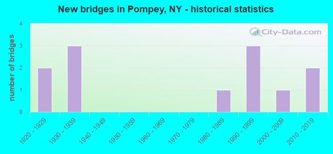
- New bridges - historical statistics
- 21920-1929
- 31930-1939
- 11980-1989
- 31990-1999
- 12000-2009
- 22010-2019
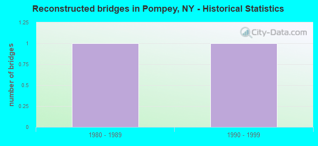
- Reconstructed bridges - Historical Statistics
- 11980-1989
- 11990-1999
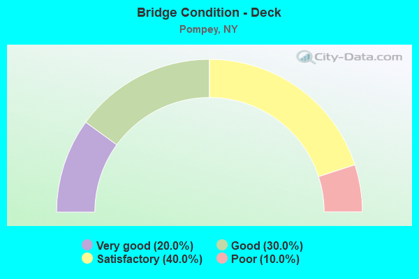
- Bridge Condition - Deck
- 20.0%Very good
- 30.0%Good
- 40.0%Satisfactory
- 10.0%Poor
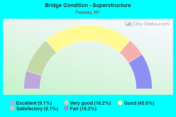
- Bridge Condition - Superstructure
- 9.1%Excellent
- 18.2%Very good
- 45.5%Good
- 9.1%Satisfactory
- 18.2%Fair
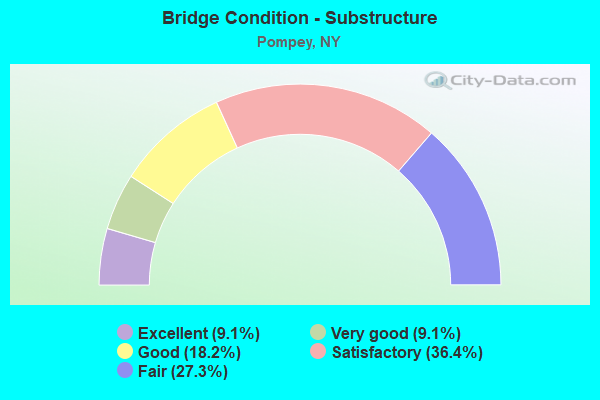
- Bridge Condition - Substructure
- 9.1%Excellent
- 9.1%Very good
- 18.2%Good
- 36.4%Satisfactory
- 27.3%Fair
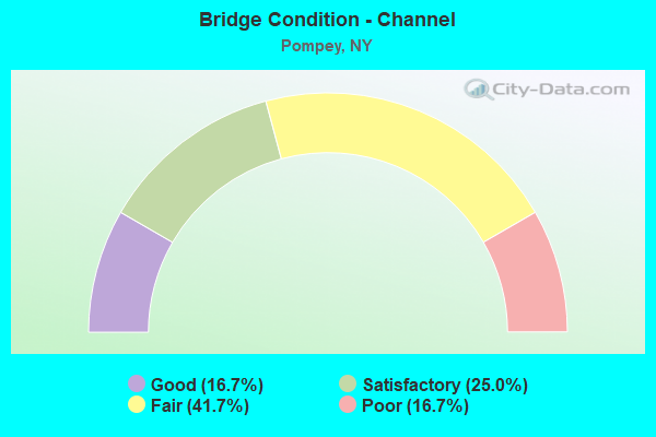
- Bridge Condition - Channel
- 16.7%Good
- 25.0%Satisfactory
- 41.7%Fair
- 16.7%Poor
Find on map >> Show street view
Structure Number: 10158, Location: 6.4 MI NE JCT RTS 20 + 91 (Lat: 42.912842, Lng: -75.909039), Route carried "on" structure: US 20, Year Built: 1931, Status: Open, Structure Length: 1.49m (4.89ft), Average Daily Traffic: 2,040 (year 2020), Truck Traffic: 10%, Average Future Daily Traffic: 2,109 (year 2040), Features Intersected: LIMESTONE CREEK
Minimum Vertical Clearance: 30+ m (98+ ft), Kilometerpoint: 50.120, Lanes on structure: 2, Base Highway Network: Yes, Owner: State Highway Agency, Approaching Roadway Width: 10.7m (35.1ft), Skew: 1 degrees, Material/Design: Steel, Design/Construction: Stringer/Multi-beam, Number Of Spans In Main Unit: 1, Length of Maximum Span: 13.7m (44.9ft), Curb-To-Curb Width: 10.7m (35.1ft), Out-to-Out Width: 11.5m (37.7ft)
Condition: Deck: Poor, Superstructure: Fair, Substructure: Fair, Channel: Poor, Operating Rating: 39.9 metric tons, Method Used To Determine Operating Rating: Load Factor (LF), Inventory Rating: 23.6 metric tons, Method Used To Determine Inventory Rating: Load Factor (LF), Structural Evaluation: Somewhat better than minimum adequacy, Deck Geometry: Somewhat better than minimum adequacy, Waterway Adequacy: Somewhat better than minimum adequacy, Approach Roadway Alignment: Equal to present desirable criteria, Length Of Structure Improvement: 1.49m (4.89ft), Designated Inspection Frequency: Every 24 months, Inspection Date: November 2020, Bridge Improvement Cost: $547,000, Roadway Improvement Cost: $320,000, Total Project Cost: $867,000 ( Estimate for 2021), Deck Structure Type: Concrete Cast-file-Place, Wearing Surface/Protective System: Wearing Surface: Bituminous
Find on map >> Show street view
Structure Number: 220823, Location: 1.7 MI S MANLIUS (Lat: 42.968319, Lng: -75.978931), Route carried "on" structure: Other road , Year Built: 1928, Status: Open, Structure Length: 1.16m (3.81ft), Average Daily Traffic: 225 (year 2016), Truck Traffic: 4%, Average Future Daily Traffic: 315 (year 2036), Design Load: HS 20, Features Intersected: W BR LIMESTONE CK, Facility Carried by Structure: INDIAN HILL ROAD
Minimum Vertical Clearance: 30+ m (98+ ft), Kilometerpoint: 0.740, Lanes on structure: 2, Owner: Town or Township Highway Agency, Approaching Roadway Width: 5.5m (18.0ft), Skew: 1 degrees, Material/Design: Steel, Design/Construction: Stringer/Multi-beam, Number Of Spans In Main Unit: 1, Length of Maximum Span: 10.6m (34.8ft), Curb-To-Curb Width: 6.0m (19.7ft), Out-to-Out Width: 6.6m (21.7ft)
Condition: Deck: Good, Superstructure: Good, Substructure: Fair, Channel: Satisfactory, Operating Rating: 63.5 metric tons, Method Used To Determine Operating Rating: Allowable Stress (AS), Inventory Rating: 38.1 metric tons, Method Used To Determine Inventory Rating: Allowable Stress (AS), Structural Evaluation: Somewhat better than minimum adequacy, Deck Geometry: High priority of corrective action, Waterway Adequacy: Equal to present desirable criteria, Approach Roadway Alignment: Meets minimum limits, Length Of Structure Improvement: 1.15m (3.77ft), Designated Inspection Frequency: Every 24 months, Inspection Date: April 2020, Bridge Improvement Cost: $245,000, Roadway Improvement Cost: $144,000, Total Project Cost: $389,000 ( Estimate for 2021), Deck Structure Type: Concrete Cast-file-Place, Wearing Surface/Protective System: Wearing Surface: Bituminous, Deck Protection: Epoxy Coated Reinforcing
Find on map >> Show street view
Structure Number: 32079, Location: 1 MILE SOUTH OF U S 20 (Lat: 42.901789, Lng: -75.915636), Route carried "on" structure: County highway , Year Built: 2002, Status: Open, Structure Length: 0.76m (2.49ft), Average Daily Traffic: 1,515 (year 2016), Truck Traffic: 8%, Average Future Daily Traffic: 2,121 (year 2036), Design Load: HS 25 or greater, Features Intersected: CHEESE FACTRY GLF, Facility Carried by Structure: ORAN DELPHI ROAD
Minimum Vertical Clearance: 30+ m (98+ ft), Kilometerpoint: 6.211, Lanes on structure: 2, Owner: County Highway Agency, Approaching Roadway Width: 10.4m (34.1ft), Material/Design: Concrete, Design/Construction: Frame, Number Of Spans In Main Unit: 1, Length of Maximum Span: 7.0m (23.0ft), Curb-To-Curb Width: 10.4m (34.1ft), Out-to-Out Width: 11.4m (37.4ft)
Condition: Deck: Good, Superstructure: Good, Substructure: Good, Channel: Fair, Operating Rating: 77.6 metric tons, Method Used To Determine Operating Rating: Field evaluation and documented engineering judgment, Inventory Rating: 40.8 metric tons, Method Used To Determine Inventory Rating: Field evaluation and documented engineering judgment, Structural Evaluation: Better than present minimum criteria, Deck Geometry: Equal to present minimum criteria, Waterway Adequacy: Meets minimum limits, Approach Roadway Alignment: Equal to present desirable criteria, Length Of Structure Improvement: 0.76m (2.49ft), Designated Inspection Frequency: Every 24 months, Inspection Date: June 2020, Bridge Improvement Cost: $587,000, Roadway Improvement Cost: $344,000, Total Project Cost: $932,000 ( Estimate for 2021), Wearing Surface/Protective System: Wearing Surface: Bituminous, Membrane: Other
Find on map >> Show street view
Structure Number: 320819, Location: 1.1 MI NNE DELPHI (Lat: 42.890611, Lng: -75.909508), Route carried "on" structure: Other road , Year Built: 1931, Year Reconstructed: 1998, Status: Posted for load, Structure Length: 1.25m (4.10ft), Average Daily Traffic: 126 (year 2017), Truck Traffic: 8%, Average Future Daily Traffic: 176 (year 2037), Features Intersected: LIMESTONE CREEK, Facility Carried by Structure: TRACY ROAD
Minimum Vertical Clearance: 30+ m (98+ ft), Kilometerpoint: 0.402, Lanes on structure: 2, Owner: County Highway Agency, Approaching Roadway Width: 6.1m (20.0ft), Skew: 1 degrees, Material/Design: Steel, Design/Construction: Stringer/Multi-beam, Number Of Spans In Main Unit: 1, Length of Maximum Span: 11.8m (38.7ft), Curb-To-Curb Width: 8.0m (26.2ft), Out-to-Out Width: 8.6m (28.2ft)
Condition: Deck: Satisfactory, Superstructure: Satisfactory, Substructure: Satisfactory, Channel: Fair, Operating Rating: 25.4 metric tons, Method Used To Determine Operating Rating: Allowable Stress (AS), Inventory Rating: 16.3 metric tons, Method Used To Determine Inventory Rating: Allowable Stress (AS), Structural Evaluation: Somewhat better than minimum adequacy, Deck Geometry: Somewhat better than minimum adequacy, Waterway Adequacy: Equal to present desirable criteria, Approach Roadway Alignment: Better than present minimum criteria, Bridge Posting: Required (Relationship of Operating Rating to Maximum Legal Load: > 39.9% below), Length Of Structure Improvement: 1.24m (4.07ft), Designated Inspection Frequency: Every 12 months, Inspection Date: April 2021, Bridge Improvement Cost: $351,000, Roadway Improvement Cost: $206,000, Total Project Cost: $557,000 ( Estimate for 2021), Deck Structure Type: Wood or Timber, Wearing Surface/Protective System: Wearing Surface: Bituminous
Find on map >> Show street view
Structure Number: 320822, Location: BET CR5 & CR146-POMPEY HO (Lat: 42.955964, Lng: -75.918958), Route carried "on" structure: Other road , Year Built: 1935, Year Reconstructed: 1994, Status: Open, Structure Length: 1.68m (5.51ft), Average Daily Traffic: 59 (year 2017), Truck Traffic: 8%, Average Future Daily Traffic: 83 (year 2037), Features Intersected: LIMESTONE CREEK, Facility Carried by Structure: NUMBER 2 EAST RD
Minimum Vertical Clearance: 30+ m (98+ ft), Kilometerpoint: 0.692, Lanes on structure: 2, Owner: County Highway Agency, Approaching Roadway Width: 4.9m (16.1ft), Skew: 2 degrees, Material/Design: Steel, Design/Construction: Stringer/Multi-beam, Number Of Spans In Main Unit: 1, Length of Maximum Span: 15.5m (50.9ft), Curb-To-Curb Width: 7.3m (24.0ft), Out-to-Out Width: 8.0m (26.2ft)
Condition: Deck: Satisfactory, Superstructure: Good, Substructure: Satisfactory, Channel: Fair, Operating Rating: 29.9 metric tons, Method Used To Determine Operating Rating: Load Factor (LF), Inventory Rating: 18.1 metric tons, Method Used To Determine Inventory Rating: Load Factor (LF), Structural Evaluation: Somewhat better than minimum adequacy, Deck Geometry: Equal to present minimum criteria, Waterway Adequacy: Meets minimum limits, Approach Roadway Alignment: Meets minimum limits, Length Of Structure Improvement: 1.67m (5.48ft), Designated Inspection Frequency: Every 24 months, Inspection Date: July 2020, Bridge Improvement Cost: $457,000, Roadway Improvement Cost: $268,000, Total Project Cost: $725,000 ( Estimate for 2021), Deck Structure Type: Concrete Cast-file-Place, Wearing Surface/Protective System: Wearing Surface: Bituminous, Membrane: Other
Find on map >> Show street view
Structure Number: 320824, Location: 1.2 MILES S OF MANLIUS (Lat: 42.984756, Lng: -75.984681), Route carried "on" structure: Other road , Year Built: 1989, Status: Open, Structure Length: 1.68m (5.51ft), Average Daily Traffic: 936 (year 2018), Truck Traffic: 2%, Average Future Daily Traffic: 1,310 (year 2038), Features Intersected: W BR LIMESTONE CK, Facility Carried by Structure: BRICKYARD FLLS RD
Minimum Vertical Clearance: 30+ m (98+ ft), Kilometerpoint: 0.611, Lanes on structure: 2, Owner: County Highway Agency, Approaching Roadway Width: 7.3m (24.0ft), Skew: 1 degrees, Material/Design: Steel, Design/Construction: Stringer/Multi-beam, Number Of Spans In Main Unit: 1, Length of Maximum Span: 16.1m (52.8ft), Curb-To-Curb Width: 8.8m (28.9ft), Out-to-Out Width: 9.4m (30.8ft)
Condition: Deck: Satisfactory, Superstructure: Good, Substructure: Satisfactory, Channel: Satisfactory, Operating Rating: 52.6 metric tons, Method Used To Determine Operating Rating: Load Factor (LF), Inventory Rating: 30.8 metric tons, Method Used To Determine Inventory Rating: Load Factor (LF), Structural Evaluation: Equal to present minimum criteria, Deck Geometry: Somewhat better than minimum adequacy, Waterway Adequacy: Equal to present desirable criteria, Approach Roadway Alignment: Equal to present desirable criteria, Length Of Structure Improvement: 1.67m (5.48ft), Designated Inspection Frequency: Every 24 months, Inspection Date: April 2020, Bridge Improvement Cost: $428,000, Roadway Improvement Cost: $251,000, Total Project Cost: $679,000 ( Estimate for 2021), Deck Structure Type: Concrete Cast-file-Place, Wearing Surface/Protective System: Wearing Surface: Bituminous, Membrane: Other
Find on map >> Show street view
Structure Number: 331259, Location: .5 MI E OF DELPHI (Lat: 42.876236, Lng: -75.902928), Route carried "on" structure: County highway , Year Built: 1928, Status: Open, Structure Length: 1.19m (3.90ft), Average Daily Traffic: 111 (year 2019), Truck Traffic: 8%, Average Future Daily Traffic: 155 (year 2039), Features Intersected: LIMESTONE CREEK, Facility Carried by Structure: POMPEY HOLLOW RD
Minimum Vertical Clearance: 30+ m (98+ ft), Kilometerpoint: 0.660, Lanes on structure: 2, Owner: County Highway Agency, Approaching Roadway Width: 6.1m (20.0ft), Material/Design: Steel, Design/Construction: Stringer/Multi-beam, Number Of Spans In Main Unit: 2, Length of Maximum Span: 5.4m (17.7ft), Curb-To-Curb Width: 6.9m (22.6ft), Out-to-Out Width: 7.3m (24.0ft)
Condition: Deck: Satisfactory, Superstructure: Fair, Substructure: Fair, Channel: Poor, Operating Rating: 38.1 metric tons, Method Used To Determine Operating Rating: Load Factor (LF), Inventory Rating: 22.7 metric tons, Method Used To Determine Inventory Rating: Load Factor (LF), Structural Evaluation: Somewhat better than minimum adequacy, Deck Geometry: Meets minimum limits, Waterway Adequacy: Meets minimum limits, Approach Roadway Alignment: Equal to present minimum criteria, Length Of Structure Improvement: 1.18m (3.87ft), Designated Inspection Frequency: Every 24 months, Inspection Date: September 2021, Bridge Improvement Cost: $319,000, Roadway Improvement Cost: $187,000, Total Project Cost: $506,000 ( Estimate for 2021), Deck Structure Type: Concrete Cast-file-Place, Wearing Surface/Protective System: Wearing Surface: Bituminous
Find on map >> Show street view
Structure Number: 33126, Location: 5.3 MI SE POMPEY CENTER (Lat: 42.870511, Lng: -75.902917), Route carried "on" structure: County highway , Year Built: 2017, Status: Open, Structure Length: 1.16m (3.81ft), Average Daily Traffic: 345 (year 2019), Truck Traffic: 8%, Average Future Daily Traffic: 483 (year 2039), Design Load: HS 20, Features Intersected: LIMESTONE CREEK, Facility Carried by Structure: DELPHI FALLS ROAD
Minimum Vertical Clearance: 30+ m (98+ ft), Kilometerpoint: 1.142, Lanes on structure: 2, Owner: County Highway Agency, Approaching Roadway Width: 7.6m (24.9ft), Material/Design: Concrete, Design/Construction: Frame, Number Of Spans In Main Unit: 1, Length of Maximum Span: 11.0m (36.1ft), Curb-To-Curb Width: 8.5m (27.9ft), Out-to-Out Width: 10.4m (34.1ft)
Condition: Deck: Very good, Superstructure: Very good, Substructure: Very good, Channel: Good, Operating Rating: 80.4 metric tons, Method Used To Determine Operating Rating: Field evaluation and documented engineering judgment, Inventory Rating: 32.7 metric tons, Method Used To Determine Inventory Rating: Field evaluation and documented engineering judgment, Structural Evaluation: Equal to present desirable criteria, Deck Geometry: Equal to present minimum criteria, Waterway Adequacy: Meets minimum limits, Approach Roadway Alignment: Equal to present desirable criteria, Length Of Structure Improvement: 1.15m (3.77ft), Designated Inspection Frequency: Every 24 months, Inspection Date: November 2021, Bridge Improvement Cost: $307,000, Roadway Improvement Cost: $180,000, Total Project Cost: $487,000 ( Estimate for 2021), Wearing Surface/Protective System: Wearing Surface: Bituminous, Membrane: Other
Find on map >> Show street view
Structure Number: 331261, Location: 0.8 MI SE OF DELPHI FALLS (Lat: 42.862650, Lng: -75.904378), Route carried "on" structure: County highway , Year Built: 1994, Status: Open, Structure Length: 0.73m (2.40ft), Average Daily Traffic: 70 (year 2017), Truck Traffic: 8%, Average Future Daily Traffic: 98 (year 2037), Features Intersected: LIMESTONE CREEK, Facility Carried by Structure: CARDNER ROAD
Minimum Vertical Clearance: 30+ m (98+ ft), Kilometerpoint: 1.818, Lanes on structure: 2, Owner: County Highway Agency, Approaching Roadway Width: 8.2m (26.9ft), Skew: 1 degrees, Material/Design: Concrete, Design/Construction: Culvert, Number Of Spans In Main Unit: 1, Length of Maximum Span: 6.7m (22.0ft)
Condition: Channel: Satisfactory, Culverts: Satisfactory, Operating Rating: 77.3 metric tons, Method Used To Determine Operating Rating: Field evaluation and documented engineering judgment, Inventory Rating: 40.8 metric tons, Method Used To Determine Inventory Rating: Field evaluation and documented engineering judgment, Structural Evaluation: Equal to present minimum criteria, Waterway Adequacy: Meets minimum limits, Approach Roadway Alignment: Equal to present desirable criteria, Length Of Structure Improvement: 0.73m (2.40ft), Designated Inspection Frequency: Every 24 months, Inspection Date: September 2020, Bridge Improvement Cost: $140,000, Roadway Improvement Cost: $82,000, Total Project Cost: $221,000 ( Estimate for 2021)
Find on map >> Show street view
Structure Number: 331264, Location: 0.5 MI S OF ORAN (Lat: 42.970658, Lng: -75.933764), Route carried "on" structure: County highway , Year Built: 2019, Status: Open, Structure Length: 2.29m (7.51ft), Average Daily Traffic: 1,436 (year 2018), Truck Traffic: 7%, Average Future Daily Traffic: 2,010 (year 2038), Design Load: HL 93, Features Intersected: LIMESTONE CREEK, Facility Carried by Structure: ORAN - DELPHI ROAD
Minimum Vertical Clearance: 32.69m (107.25ft), Kilometerpoint: 14.111, Lanes on structure: 2, Owner: County Highway Agency, Approaching Roadway Width: 10.4m (34.1ft), Material/Design: Prestressed concrete, Design/Construction: Box Beam or Girders - Multiple, Number Of Spans In Main Unit: 1, Length of Maximum Span: 22.3m (73.2ft), Curb-To-Curb Width: 10.5m (34.4ft), Out-to-Out Width: 11.5m (37.7ft)
Condition: Deck: Very good, Superstructure: Excellent, Substructure: Excellent, Channel: Good, Inventory Rating: 58.1 metric tons, Method Used To Determine Inventory Rating: Load Factor (LF), Structural Evaluation: Superior to present desirable criteria, Deck Geometry: Equal to present minimum criteria, Waterway Adequacy: Meets minimum limits, Approach Roadway Alignment: Equal to present desirable criteria, Length Of Structure Improvement: 2.28m (7.48ft), Designated Inspection Frequency: Every 24 months, Inspection Date: November 2021, Bridge Improvement Cost: $867,000, Roadway Improvement Cost: $508,000, Total Project Cost: $1,375,000 ( Estimate for 2021), Deck Structure Type: Concrete Cast-file-Place, Wearing Surface/Protective System: Wearing Surface: Integral Concrete, Deck Protection: Epoxy Coated Reinforcing
Find on map >> Show street view
Structure Number: 331266, Location: 3.2 MILES S OF MANLIUS (Lat: 42.950175, Lng: -75.982389), Route carried "on" structure: County highway , Year Built: 1993, Status: Open, Structure Length: 1.10m (3.61ft), Average Daily Traffic: 758 (year 2016), Truck Traffic: 3%, Average Future Daily Traffic: 1,061 (year 2036), Features Intersected: W B LIMESTONE CRK, Facility Carried by Structure: WATERVALE ROAD
Minimum Vertical Clearance: 30+ m (98+ ft), Kilometerpoint: 3.443, Lanes on structure: 2, Owner: County Highway Agency, Approaching Roadway Width: 6.1m (20.0ft), Skew: 1 degrees, Material/Design: Aluminum, Iron, Design/Construction: Arch - Deck, Number Of Spans In Main Unit: 1, Length of Maximum Span: 7.9m (25.9ft), Curb-To-Curb Width: 9.8m (32.2ft), Out-to-Out Width: 13.4m (44.0ft)
Condition: Superstructure: Good, Substructure: Good, Channel: Fair, Operating Rating: 78.2 metric tons, Method Used To Determine Operating Rating: Field evaluation and documented engineering judgment, Inventory Rating: 32.7 metric tons, Method Used To Determine Inventory Rating: Field evaluation and documented engineering judgment, Structural Evaluation: Better than present minimum criteria, Deck Geometry: Equal to present minimum criteria, Waterway Adequacy: Meets minimum limits, Approach Roadway Alignment: Equal to present desirable criteria, Length Of Structure Improvement: 1.09m (3.58ft), Designated Inspection Frequency: Every 24 months, Inspection Date: August 2021, Bridge Improvement Cost: $265,000, Roadway Improvement Cost: $155,000, Total Project Cost: $420,000 ( Estimate for 2021), Deck Structure Type: Concrete Cast-file-Place, Wearing Surface/Protective System: Wearing Surface: Bituminous
Find on map >> Show street view
Structure Number: 331267, Location: 1.6 MI S MANLIUS (Lat: 42.980356, Lng: -75.980883), Route carried "on" structure: County highway , Year Built: 1990, Status: Open, Structure Length: 1.55m (5.09ft), Average Daily Traffic: 1,431 (year 2020), Truck Traffic: 4%, Average Future Daily Traffic: 2,003 (year 2040), Features Intersected: W.BR.LIMESTONE CK, Facility Carried by Structure: BROADFIELD ROAD
Minimum Vertical Clearance: 30+ m (98+ ft), Kilometerpoint: 4.006, Lanes on structure: 2, Owner: County Highway Agency, Approaching Roadway Width: 11.3m (37.1ft), Material/Design: Steel, Design/Construction: Stringer/Multi-beam, Number Of Spans In Main Unit: 1, Length of Maximum Span: 14.6m (47.9ft), Curb-To-Curb Width: 10.5m (34.4ft), Out-to-Out Width: 11.3m (37.1ft)
Condition: Deck: Good, Superstructure: Very good, Substructure: Satisfactory, Channel: Fair, Operating Rating: 53.5 metric tons, Method Used To Determine Operating Rating: Load Factor (LF), Inventory Rating: 31.8 metric tons, Method Used To Determine Inventory Rating: Load Factor (LF), Structural Evaluation: Equal to present minimum criteria, Deck Geometry: Equal to present minimum criteria, Waterway Adequacy: Equal to present desirable criteria, Approach Roadway Alignment: Equal to present desirable criteria, Length Of Structure Improvement: 1.55m (5.09ft), Designated Inspection Frequency: Every 24 months, Inspection Date: April 2020, Bridge Improvement Cost: $419,000, Roadway Improvement Cost: $245,000, Total Project Cost: $664,000 ( Estimate for 2021), Deck Structure Type: Concrete Cast-file-Place, Wearing Surface/Protective System: Wearing Surface: Bituminous, Membrane: Other