Bridge Statistics for Pooler, Georgia (GA)
Condition, Traffic, Stress, Structural Evaluation, Project Costs
- National Bridge Inventory (NBI) Statistics
- 28Number of bridges
- 449ft / 137mTotal length
- $36,691,000Total costs
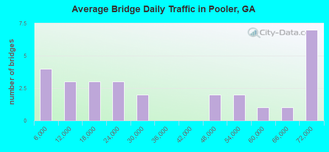
- 998,680Total average daily traffic
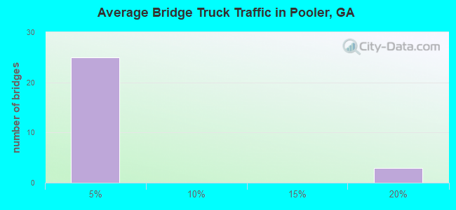
- 40,800Total average daily truck traffic
- National Bridge Inventory (NBI) Registered Bridges for Pooler
- No street view available for this location
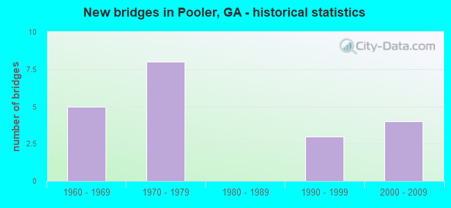
- New bridges - historical statistics
- 51960-1969
- 81970-1979
- 31990-1999
- 42000-2009
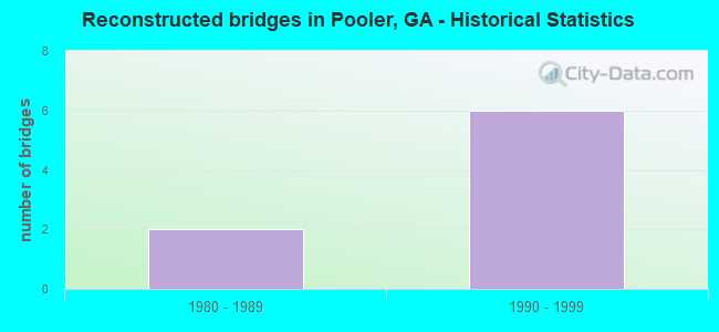
- Reconstructed bridges - Historical Statistics
- 21980-1989
- 61990-1999
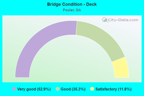
- Bridge Condition - Deck
- 52.9%Very good
- 35.3%Good
- 11.8%Satisfactory
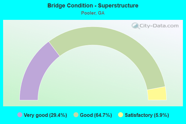
- Bridge Condition - Superstructure
- 29.4%Very good
- 64.7%Good
- 5.9%Satisfactory
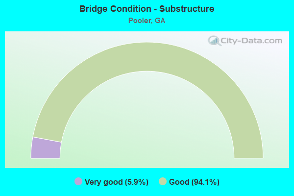
- Bridge Condition - Substructure
- 5.9%Very good
- 94.1%Good
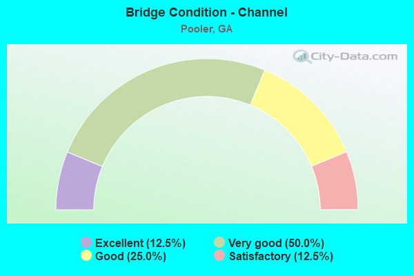
- Bridge Condition - Channel
- 12.5%Excellent
- 50.0%Very good
- 25.0%Good
- 12.5%Satisfactory
Find on map >> Show street view
Structure Number: 510041, Location: 10 MI NW OF SAVANNAH (Lat: 32.095728, Lng: -81.236478), Route carried "on" structure: City street 4068, Year Built: 1975, Status: Open, Structure Length: 8.75m (28.71ft), Average Daily Traffic: 3,200 (year 2011), Truck Traffic: 1%, Average Future Daily Traffic: 4,800 (year 2031), Design Load: HS 20+Mod, Features Intersected: I-95 (SR 405), Facility Carried by Structure: PINE BARREN
Minimum Vertical Clearance: 30+ m (98+ ft), Kilometerpoint: 9.656, Lanes on structure: 2, Lanes under structure: 6, Base Highway Network: Yes, Owner: State Highway Agency, Approaching Roadway Width: 7.0m (23.0ft), Skew: 2 degrees, Material/Design: Steel continuous, Design/Construction: Stringer/Multi-beam, Number Of Spans In Main Unit: 4, Length of Maximum Span: 29.6m (97.1ft), Curb-To-Curb Width: 13.1m (43.0ft), Out-to-Out Width: 14.2m (46.6ft)
Condition: Deck: Very good, Superstructure: Very good, Substructure: Good, Operating Rating: 61.6 metric tons, Method Used To Determine Operating Rating: Allowable Stress (AS), Inventory Rating: 32.6 metric tons, Method Used To Determine Inventory Rating: Allowable Stress (AS), Structural Evaluation: Better than present minimum criteria, Deck Geometry: Equal to present minimum criteria, Underclear: Better than present minimum criteria, Approach Roadway Alignment: Equal to present desirable criteria, Designated Inspection Frequency: Every 24 months, Inspection Date: July 2020, Bridge Improvement Cost: $1,121,000, Roadway Improvement Cost: $112,000, Total Project Cost: $1,682,000, Deck Structure Type: Concrete Cast-file-Place, Wearing Surface/Protective System: Wearing Surface: Epoxy Overlay
Find on map >> Show street view
Structure Number: 51007, Location: 7 MI SW OF SAVANNAH (Lat: 32.027747, Lng: -81.269358), Route carried "on" structure: County highway 2773, Year Built: 1969, Status: Open, Structure Length: 8.72m (28.61ft), Average Daily Traffic: 2,900 (year 2011), Truck Traffic: 1%, Average Future Daily Traffic: 4,350 (year 2031), Design Load: HS 15, Features Intersected: I-95 (SR 405), Facility Carried by Structure: LITTLE NECK ROAD
Minimum Vertical Clearance: 30+ m (98+ ft), Kilometerpoint: 4.828, Lanes on structure: 2, Lanes under structure: 6, Base Highway Network: Yes, Owner: State Highway Agency, Approaching Roadway Width: 7.0m (23.0ft), Skew: 2 degrees, Material/Design: Steel continuous, Design/Construction: Stringer/Multi-beam, Number Of Spans In Main Unit: 4, Length of Maximum Span: 30.2m (99.1ft), Curb or Sidewalk Widths: Left: 0.3m (1.0ft), Right: 0.3m (1.0ft), Curb-To-Curb Width: 8.1m (26.6ft), Out-to-Out Width: 9.4m (30.8ft)
Condition: Deck: Satisfactory, Superstructure: Good, Substructure: Good, Operating Rating: 29.0 metric tons, Method Used To Determine Operating Rating: Load Factor (LF), Inventory Rating: 17.2 metric tons, Method Used To Determine Inventory Rating: Load Factor (LF), Structural Evaluation: Meets minimum limits, Deck Geometry: High priority of corrective action, Underclear: Equal to present minimum criteria, Approach Roadway Alignment: Equal to present desirable criteria, Length Of Structure Improvement: 48.95m (160.60ft), Designated Inspection Frequency: Every 24 months, Inspection Date: July 2020, Bridge Improvement Cost: $1,117,000, Roadway Improvement Cost: $112,000, Total Project Cost: $1,676,000, Deck Structure Type: Concrete Cast-file-Place
Find on map >> Show street view
Structure Number: 510084, Location: 7 MI W OF SAVANNAH (Lat: 32.073397, Lng: -81.238831), Route carried "on" structure: Interstate 16, Year Built: 1966, Status: Open, Structure Length: 0.91m (2.99ft), Average Daily Traffic: 55,720 (year 2011), Truck Traffic: 1%, Average Future Daily Traffic: 83,580 (year 2031), Design Load: HS 20+Mod, Features Intersected: HARDIN CANAL
Minimum Vertical Clearance: 30+ m (98+ ft), Kilometerpoint: 254.276, Lanes on structure: 4, Base Highway Network: Yes, Owner: State Highway Agency, Approaching Roadway Width: 26.5m (86.9ft), Skew: 14 degrees, Material/Design: Concrete, Design/Construction: Culvert, Number Of Spans In Main Unit: 2, Length of Maximum Span: 4.3m (14.1ft)
Condition: Channel: Good, Culverts: Good, Operating Rating: 55.3 metric tons, Method Used To Determine Operating Rating: Field evaluation and documented engineering judgment, Inventory Rating: 32.6 metric tons, Method Used To Determine Inventory Rating: Field evaluation and documented engineering judgment, Structural Evaluation: Better than present minimum criteria, Waterway Adequacy: Equal to present desirable criteria, Approach Roadway Alignment: Equal to present desirable criteria, Designated Inspection Frequency: Every 24 months, Inspection Date: June 2020, Bridge Improvement Cost: $181,000, Roadway Improvement Cost: $18,000, Total Project Cost: $272,000
Find on map >> Show street view
Structure Number: 510107, Location: 10 MI SW OF SAVANNAH (Lat: 32.031397, Lng: -81.267558), Route carried "on" structure: Interstate 95, Year Built: 1969, Year Reconstructed: 1993, Status: Open, Structure Length: 4.88m (16.01ft), Average Daily Traffic: 65,030 (year 2011), Truck Traffic: 1%, Average Future Daily Traffic: 97,545 (year 2031), Design Load: HS 20+Mod, Features Intersected: LITTLE OGEECHEE RIVER
Minimum Vertical Clearance: 30+ m (98+ ft), Kilometerpoint: 154.497, Lanes on structure: 6, Base Highway Network: Yes, Owner: State Highway Agency, Approaching Roadway Width: 36.9m (121.1ft), Skew: 30 degrees, Material/Design: Concrete, Design/Construction: Tee Beam, Number Of Spans In Main Unit: 4, Length of Maximum Span: 12.2m (40.0ft), Curb-To-Curb Width: 40.5m (132.9ft), Out-to-Out Width: 42.4m (139.1ft)
Condition: Deck: Good, Superstructure: Good, Substructure: Good, Channel: Good, Operating Rating: 50.8 metric tons, Method Used To Determine Operating Rating: Load Factor (LF), Inventory Rating: 30.8 metric tons, Method Used To Determine Inventory Rating: Load Factor (LF), Structural Evaluation: Better than present minimum criteria, Deck Geometry: Superior to present desirable criteria, Waterway Adequacy: Equal to present desirable criteria, Approach Roadway Alignment: Equal to present desirable criteria, Designated Inspection Frequency: Every 24 months, Inspection Date: July 2020, Bridge Improvement Cost: $1,307,000, Roadway Improvement Cost: $131,000, Total Project Cost: $1,961,000, Deck Structure Type: Concrete Cast-file-Place
Find on map >> Show street view
Structure Number: 510109, Location: 7 MI W OF SAVANNAH (Lat: 32.074217, Lng: -81.245994), Route carried "on" structure: Interstate 95, Year Built: 1970, Year Reconstructed: 1993, Status: Open, Structure Length: 9.11m (29.89ft), Average Daily Traffic: 67,810 (year 2011), Truck Traffic: 16%, Average Future Daily Traffic: 101,715 (year 2031), Design Load: HS 20+Mod, Features Intersected: I-16 (SR 404)
Minimum Vertical Clearance: 30+ m (98+ ft), Kilometerpoint: 159.325, Lanes on structure: 8, Lanes under structure: 6, Base Highway Network: Yes, Owner: State Highway Agency, Approaching Roadway Width: 35.4m (116.1ft), Skew: 33 degrees, Material/Design: Steel continuous, Design/Construction: Stringer/Multi-beam, Number Of Spans In Main Unit: 4, Length of Maximum Span: 26.8m (87.9ft), Curb-To-Curb Width: 43.6m (143.0ft), Out-to-Out Width: 45.6m (149.6ft)
Condition: Deck: Very good, Superstructure: Good, Substructure: Good, Operating Rating: 29.9 metric tons, Method Used To Determine Operating Rating: Load Factor (LF), Inventory Rating: 18.1 metric tons, Method Used To Determine Inventory Rating: Load Factor (LF), Structural Evaluation: Meets minimum limits, Deck Geometry: Superior to present desirable criteria, Underclear: Meets minimum limits, Approach Roadway Alignment: Equal to present desirable criteria, Designated Inspection Frequency: Every 24 months, Inspection Date: June 2020, Bridge Improvement Cost: $3,080,000, Roadway Improvement Cost: $308,000, Total Project Cost: $4,620,000, Deck Structure Type: Concrete Cast-file-Place, Wearing Surface/Protective System: Wearing Surface: Epoxy Overlay
Find on map >> Show street view
Structure Number: 510111, Location: 10 MI NE OF SAVANNAH (Lat: 32.101900, Lng: -81.236828), Route carried "on" structure: Interstate 95, Year Built: 1975, Year Reconstructed: 1996, Status: Open, Structure Length: 6.37m (20.90ft), Average Daily Traffic: 67,810 (year 2011), Truck Traffic: 16%, Average Future Daily Traffic: 101,715 (year 2031), Design Load: HS 20+Mod, Features Intersected: NS RAILROAD
Minimum Vertical Clearance: 30+ m (98+ ft), Kilometerpoint: 162.544, Lanes on structure: 3, Base Highway Network: Yes, Owner: State Highway Agency, Approaching Roadway Width: 18.0m (59.1ft), Skew: 12 degrees, Material/Design: Steel continuous, Design/Construction: Stringer/Multi-beam, Number Of Spans In Main Unit: 3, Length of Maximum Span: 27.4m (89.9ft), Curb-To-Curb Width: 23.2m (76.1ft), Out-to-Out Width: 24.3m (79.7ft)
Condition: Deck: Very good, Superstructure: Very good, Substructure: Good, Operating Rating: 37.1 metric tons, Method Used To Determine Operating Rating: Load Factor (LF), Inventory Rating: 21.7 metric tons, Method Used To Determine Inventory Rating: Load Factor (LF), Structural Evaluation: Somewhat better than minimum adequacy, Deck Geometry: Superior to present desirable criteria, Underclear: Better than present minimum criteria, Approach Roadway Alignment: Equal to present desirable criteria, Designated Inspection Frequency: Every 24 months, Inspection Date: July 2020, Bridge Improvement Cost: $1,039,000, Roadway Improvement Cost: $104,000, Total Project Cost: $1,559,000, Deck Structure Type: Concrete Cast-file-Place, Wearing Surface/Protective System: Wearing Surface: Epoxy Overlay
Find on map >> Show street view
Structure Number: 510112, Location: 10 MI NE OF SAVANNAH (Lat: 32.101978, Lng: -81.237097), Route carried "on" structure: Interstate 95, Year Built: 1975, Year Reconstructed: 1996, Status: Open, Structure Length: 6.37m (20.90ft), Average Daily Traffic: 67,810 (year 2011), Truck Traffic: 16%, Average Future Daily Traffic: 101,715 (year 2031), Design Load: HS 20+Mod, Features Intersected: NS RAILROAD
Minimum Vertical Clearance: 30+ m (98+ ft), Kilometerpoint: 162.544, Lanes on structure: 2, Base Highway Network: Yes, Owner: State Highway Agency, Approaching Roadway Width: 17.7m (58.1ft), Skew: 12 degrees, Material/Design: Steel continuous, Design/Construction: Stringer/Multi-beam, Number Of Spans In Main Unit: 3, Length of Maximum Span: 27.4m (89.9ft), Curb-To-Curb Width: 23.2m (76.1ft), Out-to-Out Width: 24.3m (79.7ft)
Condition: Deck: Very good, Superstructure: Very good, Substructure: Good, Operating Rating: 32.6 metric tons, Method Used To Determine Operating Rating: Load Factor (LF), Inventory Rating: 19.0 metric tons, Method Used To Determine Inventory Rating: Load Factor (LF), Structural Evaluation: Meets minimum limits, Deck Geometry: Superior to present desirable criteria, Underclear: Better than present minimum criteria, Approach Roadway Alignment: Equal to present desirable criteria, Designated Inspection Frequency: Every 24 months, Inspection Date: July 2020, Bridge Improvement Cost: $817,000, Roadway Improvement Cost: $82,000, Total Project Cost: $1,225,000, Deck Structure Type: Concrete Cast-file-Place, Wearing Surface/Protective System: Wearing Surface: Epoxy Overlay
Find on map >> Show street view
Structure Number: 510113, Location: 10.5 MI NW OF SAVANNAH (Lat: 32.112389, Lng: -81.237828), Route carried "on" structure: Interstate 95, Year Built: 1976, Year Reconstructed: 1995, Status: Open, Structure Length: 7.22m (23.69ft), Average Daily Traffic: 71,150 (year 2011), Truck Traffic: 1%, Average Future Daily Traffic: 106,725 (year 2031), Design Load: HS 20+Mod, Features Intersected: SR 26 (US 80)
Minimum Vertical Clearance: 30+ m (98+ ft), Kilometerpoint: 164.153, Lanes on structure: 3, Lanes under structure: 6, Base Highway Network: Yes, Owner: State Highway Agency, Approaching Roadway Width: 17.7m (58.1ft), Skew: 11 degrees, Material/Design: Steel continuous, Design/Construction: Stringer/Multi-beam, Number Of Spans In Main Unit: 4, Length of Maximum Span: 22.9m (75.1ft), Curb-To-Curb Width: 23.2m (76.1ft), Out-to-Out Width: 24.2m (79.4ft)
Condition: Deck: Very good, Superstructure: Good, Substructure: Very good, Operating Rating: 39.9 metric tons, Method Used To Determine Operating Rating: Load Factor (LF), Inventory Rating: 23.5 metric tons, Method Used To Determine Inventory Rating: Load Factor (LF), Structural Evaluation: Somewhat better than minimum adequacy, Deck Geometry: Superior to present desirable criteria, Underclear: Somewhat better than minimum adequacy, Approach Roadway Alignment: Equal to present desirable criteria, Designated Inspection Frequency: Every 24 months, Inspection Date: June 2020, Bridge Improvement Cost: $1,179,000, Roadway Improvement Cost: $118,000, Total Project Cost: $1,768,000, Deck Structure Type: Concrete Cast-file-Place, Wearing Surface/Protective System: Wearing Surface: Epoxy Overlay
Find on map >> Show street view
Structure Number: 510114, Location: 10.5 MI NW OF SAVANNAH (Lat: 32.112519, Lng: -81.238169), Route carried "on" structure: Interstate 95, Year Built: 1976, Year Reconstructed: 1995, Status: Open, Structure Length: 7.22m (23.69ft), Average Daily Traffic: 71,150 (year 2011), Truck Traffic: 1%, Average Future Daily Traffic: 106,725 (year 2031), Design Load: HS 20+Mod, Features Intersected: SR 26 (US 80)
Minimum Vertical Clearance: 30+ m (98+ ft), Kilometerpoint: 164.153, Lanes on structure: 3, Lanes under structure: 6, Base Highway Network: Yes, Owner: State Highway Agency, Approaching Roadway Width: 18.0m (59.1ft), Skew: 11 degrees, Material/Design: Steel continuous, Design/Construction: Stringer/Multi-beam, Number Of Spans In Main Unit: 4, Length of Maximum Span: 22.9m (75.1ft), Curb-To-Curb Width: 23.2m (76.1ft), Out-to-Out Width: 24.2m (79.4ft)
Condition: Deck: Very good, Superstructure: Very good, Substructure: Good, Operating Rating: 36.2 metric tons, Method Used To Determine Operating Rating: Load Factor (LF), Inventory Rating: 21.7 metric tons, Method Used To Determine Inventory Rating: Load Factor (LF), Structural Evaluation: Somewhat better than minimum adequacy, Deck Geometry: Superior to present desirable criteria, Underclear: Somewhat better than minimum adequacy, Approach Roadway Alignment: Equal to present desirable criteria, Designated Inspection Frequency: Every 24 months, Inspection Date: June 2020, Bridge Improvement Cost: $1,179,000, Roadway Improvement Cost: $118,000, Total Project Cost: $1,768,000, Deck Structure Type: Concrete Cast-file-Place, Wearing Surface/Protective System: Wearing Surface: Epoxy Overlay
Find on map >> Show street view
Structure Number: 510115, Location: 1 MI N OF POOLER (Lat: 32.131758, Lng: -81.239697), Route carried "on" structure: Interstate 95, Year Built: 1976, Year Reconstructed: 1996, Status: Open, Structure Length: 3.29m (10.79ft), Average Daily Traffic: 70,130 (year 2012), Truck Traffic: 1%, Average Future Daily Traffic: 105,195 (year 2032), Design Load: HS 20+Mod, Features Intersected: PIPE MAKERS CANAL
Minimum Vertical Clearance: 30+ m (98+ ft), Kilometerpoint: 165.762, Lanes on structure: 3, Base Highway Network: Yes, Owner: State Highway Agency, Approaching Roadway Width: 18.0m (59.1ft), Skew: 12 degrees, Material/Design: Concrete, Design/Construction: Tee Beam, Number Of Spans In Main Unit: 3, Length of Maximum Span: 11.0m (36.1ft), Curb-To-Curb Width: 23.2m (76.1ft), Out-to-Out Width: 24.2m (79.4ft)
Condition: Deck: Very good, Superstructure: Good, Substructure: Good, Channel: Very good, Operating Rating: 41.7 metric tons, Method Used To Determine Operating Rating: Allowable Stress (AS), Inventory Rating: 24.4 metric tons, Method Used To Determine Inventory Rating: Allowable Stress (AS), Structural Evaluation: Equal to present minimum criteria, Deck Geometry: Superior to present desirable criteria, Waterway Adequacy: Equal to present desirable criteria, Approach Roadway Alignment: Equal to present desirable criteria, Designated Inspection Frequency: Every 24 months, Other Special Inspection Frequency: Every 24 months, Inspection Date: June 2020, Other Special Inspection Date: June 2021, Bridge Improvement Cost: $537,000, Roadway Improvement Cost: $54,000, Total Project Cost: $806,000, Deck Structure Type: Concrete Cast-file-Place, Wearing Surface/Protective System: Wearing Surface: Epoxy Overlay
Find on map >> Show street view
Structure Number: 510116, Location: 1 MI N OF POOLER (Lat: 32.131681, Lng: -81.239992), Route carried "on" structure: Interstate 95, Year Built: 1976, Year Reconstructed: 1996, Status: Open, Structure Length: 3.29m (10.79ft), Average Daily Traffic: 70,130 (year 2012), Truck Traffic: 1%, Average Future Daily Traffic: 105,195 (year 2032), Design Load: HS 20+Mod, Features Intersected: PIPE MAKERS CANAL
Minimum Vertical Clearance: 30+ m (98+ ft), Kilometerpoint: 165.762, Lanes on structure: 3, Base Highway Network: Yes, Owner: State Highway Agency, Approaching Roadway Width: 17.4m (57.1ft), Skew: 12 degrees, Material/Design: Concrete, Design/Construction: Tee Beam, Number Of Spans In Main Unit: 3, Length of Maximum Span: 11.0m (36.1ft), Curb-To-Curb Width: 23.2m (76.1ft), Out-to-Out Width: 24.2m (79.4ft)
Condition: Deck: Very good, Superstructure: Good, Substructure: Good, Channel: Very good, Operating Rating: 41.7 metric tons, Method Used To Determine Operating Rating: Load Factor (LF), Inventory Rating: 24.4 metric tons, Method Used To Determine Inventory Rating: Load Factor (LF), Structural Evaluation: Equal to present minimum criteria, Deck Geometry: Superior to present desirable criteria, Waterway Adequacy: Equal to present desirable criteria, Approach Roadway Alignment: Equal to present desirable criteria, Designated Inspection Frequency: Every 24 months, Other Special Inspection Frequency: Every 24 months, Inspection Date: June 2020, Other Special Inspection Date: June 2021, Bridge Improvement Cost: $537,000, Roadway Improvement Cost: $54,000, Total Project Cost: $806,000, Deck Structure Type: Concrete Cast-file-Place, Wearing Surface/Protective System: Wearing Surface: Epoxy Overlay
Find on map >> Show street view
Structure Number: 510135, Location: 10 MI SW OF SAVANNAH (Lat: 32.042439, Lng: -81.261969), Route carried "on" structure: City street 4067, Year Built: 1969, Status: Open, Structure Length: 11.13m (36.52ft), Average Daily Traffic: 10,210 (year 2012), Truck Traffic: 4%, Average Future Daily Traffic: 15,315 (year 2032), Design Load: HS 15, Features Intersected: I-95 (SR 405), Facility Carried by Structure: QUACCO ROAD
Minimum Vertical Clearance: 30+ m (98+ ft), Kilometerpoint: 4.828, Lanes on structure: 2, Lanes under structure: 6, Base Highway Network: Yes, Owner: State Highway Agency, Approaching Roadway Width: 6.7m (22.0ft), Material/Design: Steel continuous, Design/Construction: Stringer/Multi-beam, Number Of Spans In Main Unit: 4, Length of Maximum Span: 39.0m (128.0ft), Curb or Sidewalk Widths: Left: 0.3m (1.0ft), Right: 0.3m (1.0ft), Curb-To-Curb Width: 8.7m (28.5ft), Out-to-Out Width: 10.0m (32.8ft)
Condition: Deck: Good, Superstructure: Good, Substructure: Good, Operating Rating: 46.2 metric tons, Method Used To Determine Operating Rating: Load Factor (LF), Inventory Rating: 28.1 metric tons, Method Used To Determine Inventory Rating: Load Factor (LF), Structural Evaluation: Better than present minimum criteria, Deck Geometry: Meets minimum limits, Underclear: Equal to present minimum criteria, Approach Roadway Alignment: Equal to present desirable criteria, Designated Inspection Frequency: Every 24 months, Inspection Date: July 2020, Bridge Improvement Cost: $1,426,000, Roadway Improvement Cost: $143,000, Total Project Cost: $2,139,000, Deck Structure Type: Concrete Cast-file-Place
Find on map >> Show street view
Structure Number: 510137, Location: 0.5 MI S OF POOLER (Lat: 32.099508, Lng: -81.254647), Route carried "on" structure: City street 4067, Year Built: 1960, Status: Open, Structure Length: 0.91m (2.99ft), Average Daily Traffic: 3,510 (year 2011), Truck Traffic: 1%, Average Future Daily Traffic: 5,265 (year 2031), Design Load: H 15, Features Intersected: HARDEN CANAL, Facility Carried by Structure: RODGERS ST.
Minimum Vertical Clearance: 30+ m (98+ ft), Kilometerpoint: 11.265, Lanes on structure: 2, Base Highway Network: Yes, Owner: County Highway Agency, Approaching Roadway Width: 6.1m (20.0ft), Material/Design: Concrete, Design/Construction: Slab, Number Of Spans In Main Unit: 2, Length of Maximum Span: 4.6m (15.1ft), Curb or Sidewalk Widths: Left: 0.6m (2.0ft), Right: 0.6m (2.0ft), Curb-To-Curb Width: 7.9m (25.9ft), Out-to-Out Width: 9.7m (31.8ft)
Condition: Deck: Satisfactory, Superstructure: Satisfactory, Substructure: Good, Channel: Satisfactory, Operating Rating: 37.1 metric tons, Method Used To Determine Operating Rating: Allowable Stress (AS), Inventory Rating: 21.7 metric tons, Method Used To Determine Inventory Rating: Allowable Stress (AS), Structural Evaluation: Somewhat better than minimum adequacy, Deck Geometry: High priority of corrective action, Waterway Adequacy: Equal to present desirable criteria, Approach Roadway Alignment: Equal to present desirable criteria, Designated Inspection Frequency: Every 24 months, Inspection Date: July 2020, Bridge Improvement Cost: $117,000, Roadway Improvement Cost: $12,000, Total Project Cost: $176,000, Deck Structure Type: Concrete Cast-file-Place
Find on map >> Show street view
Structure Number: 510176, Location: 2 MI N OF POOLER (Lat: 32.141100, Lng: -81.240764), Route carried "on" structure: City street 1269, Year Built: 1994, Status: Open, Structure Length: 7.99m (26.21ft), Average Daily Traffic: 8,700 (year 2012), Truck Traffic: 1%, Average Future Daily Traffic: 13,050 (year 2032), Design Load: HS 20+Mod, Features Intersected: I-95 (SR 405), Facility Carried by Structure: AIRPORT ROAD
Minimum Vertical Clearance: 30+ m (98+ ft), Kilometerpoint: 9.656, Lanes on structure: 6, Lanes under structure: 6, Base Highway Network: Yes, Owner: State Highway Agency, Approaching Roadway Width: 33.4m (109.6ft), Skew: 20 degrees, Material/Design: Prestressed concrete, Design/Construction: Stringer/Multi-beam, Number Of Spans In Main Unit: 4, Length of Maximum Span: 26.8m (87.9ft), Curb-To-Curb Width: 34.1m (111.9ft), Out-to-Out Width: 35.1m (115.2ft)
Condition: Deck: Very good, Superstructure: Good, Substructure: Good, Operating Rating: 56.2 metric tons, Method Used To Determine Operating Rating: Load Factor (LF), Inventory Rating: 32.6 metric tons, Method Used To Determine Inventory Rating: Load Factor (LF), Structural Evaluation: Better than present minimum criteria, Deck Geometry: Superior to present desirable criteria, Underclear: Better than present minimum criteria, Approach Roadway Alignment: Equal to present desirable criteria, Designated Inspection Frequency: Every 24 months, Inspection Date: June 2020, Bridge Improvement Cost: $2,420,000, Roadway Improvement Cost: $242,000, Total Project Cost: $3,629,000, Deck Structure Type: Concrete Cast-file-Place, Wearing Surface/Protective System: Wearing Surface: Epoxy Overlay
Find on map >> Show street view
Structure Number: 51505, Location: 2 MI N.E. OF POOLER (Lat: 32.152439, Lng: -81.279528), Route carried "on" structure: Business County highway 984, Year Built: 1997, Status: Open, Structure Length: 8.53m (27.99ft), Average Daily Traffic: 3,170 (year 2011), Truck Traffic: 1%, Average Future Daily Traffic: 4,755 (year 2031), Design Load: HS 20+Mod, Features Intersected: PIPEMAKER CANAL TRIB, Facility Carried by Structure: JIMMY DELOACH PKY
Minimum Vertical Clearance: 30+ m (98+ ft), Kilometerpoint: 3.219, Lanes on structure: 4, Base Highway Network: Yes, Owner: County Highway Agency, Approaching Roadway Width: 18.0m (59.1ft), Material/Design: Prestressed concrete, Design/Construction: Stringer/Multi-beam, Number Of Spans In Main Unit: 5, Length of Maximum Span: 17.1m (56.1ft), Curb-To-Curb Width: 21.9m (71.9ft), Out-to-Out Width: 22.9m (75.1ft)
Condition: Deck: Good, Superstructure: Very good, Substructure: Good, Channel: Very good, Operating Rating: 55.3 metric tons, Method Used To Determine Operating Rating: Allowable Stress (AS), Inventory Rating: 32.6 metric tons, Method Used To Determine Inventory Rating: Allowable Stress (AS), Structural Evaluation: Better than present minimum criteria, Deck Geometry: Superior to present desirable criteria, Waterway Adequacy: Equal to present desirable criteria, Approach Roadway Alignment: Equal to present desirable criteria, Designated Inspection Frequency: Every 24 months, Inspection Date: August 2020, Bridge Improvement Cost: $1,691,000, Roadway Improvement Cost: $169,000, Total Project Cost: $2,536,000, Deck Structure Type: Concrete Cast-file-Place
Find on map >> Show street view
Structure Number: 515054, Location: 0.5 MI N OF POOLER (Lat: 32.128767, Lng: -81.258672), Route carried "on" structure: County highway 1269, Year Built: 1997, Status: Open, Structure Length: 1.16m (3.81ft), Average Daily Traffic: 18,730 (year 2011), Truck Traffic: 1%, Average Future Daily Traffic: 28,095 (year 2031), Design Load: HS 20+Mod, Features Intersected: PIPEMAKER CANAL, Facility Carried by Structure: POOLER BYPASS
Minimum Vertical Clearance: 30+ m (98+ ft), Kilometerpoint: 6.437, Lanes on structure: 2, Base Highway Network: Yes, Owner: County Highway Agency, Approaching Roadway Width: 18.3m (60.0ft), Skew: 13 degrees, Material/Design: Concrete, Design/Construction: Culvert, Number Of Spans In Main Unit: 3, Length of Maximum Span: 3.7m (12.1ft)
Condition: Channel: Very good, Culverts: Good, Operating Rating: 55.3 metric tons, Method Used To Determine Operating Rating: Field evaluation and documented engineering judgment, Inventory Rating: 32.6 metric tons, Method Used To Determine Inventory Rating: Field evaluation and documented engineering judgment, Structural Evaluation: Better than present minimum criteria, Waterway Adequacy: Equal to present desirable criteria, Approach Roadway Alignment: Equal to present desirable criteria, Designated Inspection Frequency: Every 24 months, Inspection Date: July 2020, Bridge Improvement Cost: $148,000, Roadway Improvement Cost: $15,000, Total Project Cost: $223,000
Find on map >> Show street view
Structure Number: 515057, Location: 8.5MI W OF SAVANNAH (Lat: 32.084053, Lng: -81.279806), Route carried "on" structure: County highway 1269, Year Built: 2000, Status: Open, Structure Length: 9.17m (30.09ft), Average Daily Traffic: 8,230 (year 2011), Truck Traffic: 1%, Average Future Daily Traffic: 12,345 (year 2031), Design Load: HS 20+Mod, Features Intersected: I-16 (SR 404 ), Facility Carried by Structure: POOLER PARKWAY
Minimum Vertical Clearance: 30+ m (98+ ft), Kilometerpoint: 1.609, Lanes on structure: 6, Lanes under structure: 4, Base Highway Network: Yes, Owner: State Highway Agency, Approaching Roadway Width: 24.4m (80.1ft), Skew: 20 degrees, Material/Design: Prestressed concrete, Design/Construction: Stringer/Multi-beam, Number Of Spans In Main Unit: 4, Length of Maximum Span: 32.3m (106.0ft), Curb-To-Curb Width: 28.0m (91.9ft), Out-to-Out Width: 35.3m (115.8ft)
Condition: Deck: Good, Superstructure: Good, Substructure: Good, Operating Rating: 56.2 metric tons, Method Used To Determine Operating Rating: Allowable Stress (AS), Inventory Rating: 32.6 metric tons, Method Used To Determine Inventory Rating: Allowable Stress (AS), Structural Evaluation: Better than present minimum criteria, Deck Geometry: Superior to present desirable criteria, Underclear: Superior to present desirable criteria, Approach Roadway Alignment: Equal to present desirable criteria, Designated Inspection Frequency: Every 24 months, Inspection Date: June 2020, Bridge Improvement Cost: $2,459,000, Roadway Improvement Cost: $246,000, Total Project Cost: $3,689,000, Deck Structure Type: Concrete Cast-file-Place
Find on map >> Show street view
Structure Number: 515069, Location: 0.5 M W OF SR 307 (Lat: 32.076069, Lng: -81.203297), Route carried "on" structure: County highway 810, Year Built: 2004, Status: Open, Structure Length: 0.98m (3.22ft), Average Daily Traffic: 15,300 (year 2011), Truck Traffic: 1%, Average Future Daily Traffic: 22,950 (year 2031), Design Load: HS 20+Mod, Features Intersected: OGEECHEE CANAL TRIB, Facility Carried by Structure: PINE MEADOW DRIVE
Minimum Vertical Clearance: 30+ m (98+ ft), Kilometerpoint: 0.000, Lanes on structure: 4, Base Highway Network: Yes, Owner: County Highway Agency, Approaching Roadway Width: 15.5m (50.9ft), Material/Design: Concrete, Design/Construction: Culvert, Number Of Spans In Main Unit: 3, Length of Maximum Span: 3.0m (9.8ft), Curb or Sidewalk Widths: Left: 0.6m (2.0ft), Right: 0.6m (2.0ft)
Condition: Channel: Excellent, Culverts: Good, Operating Rating: 55.3 metric tons, Method Used To Determine Operating Rating: Field evaluation and documented engineering judgment, Inventory Rating: 32.6 metric tons, Method Used To Determine Inventory Rating: Field evaluation and documented engineering judgment, Structural Evaluation: Better than present minimum criteria, Waterway Adequacy: Equal to present desirable criteria, Approach Roadway Alignment: Equal to present desirable criteria, Designated Inspection Frequency: Every 24 months, Inspection Date: July 2020, Bridge Improvement Cost: $193,000, Roadway Improvement Cost: $19,000, Total Project Cost: $290,000
Find on map >> Show street view
Structure Number: 51507, Location: 1 MI S OF SR 26 IN POOLER (Lat: 32.111119, Lng: -81.266839), Route carried "on" structure: Bypass County highway 1269, Year Built: 2003, Status: Open, Structure Length: 16.15m (52.99ft), Average Daily Traffic: 15,250 (year 2011), Truck Traffic: 1%, Average Future Daily Traffic: 22,875 (year 2031), Design Load: HS 20+Mod, Features Intersected: CSX RAILROAD, Facility Carried by Structure: POOLER BY-PASS
Minimum Vertical Clearance: 30+ m (98+ ft), Kilometerpoint: 4.828, Lanes on structure: 2, Base Highway Network: Yes, Owner: County Highway Agency, Approaching Roadway Width: 11.3m (37.1ft), Skew: 19 degrees, Material/Design: Prestressed concrete, Design/Construction: Stringer/Multi-beam, Number Of Spans In Main Unit: 6, Length of Maximum Span: 31.1m (102.0ft), Curb-To-Curb Width: 11.4m (37.4ft), Out-to-Out Width: 12.3m (40.4ft)
Condition: Deck: Good, Superstructure: Good, Substructure: Good, Operating Rating: 56.2 metric tons, Method Used To Determine Operating Rating: Allowable Stress (AS), Inventory Rating: 32.6 metric tons, Method Used To Determine Inventory Rating: Allowable Stress (AS), Structural Evaluation: Better than present minimum criteria, Deck Geometry: Equal to present minimum criteria, Underclear: Superior to present desirable criteria, Approach Roadway Alignment: Equal to present desirable criteria, Designated Inspection Frequency: Every 24 months, Inspection Date: May 2020, Bridge Improvement Cost: $2,071,000, Roadway Improvement Cost: $207,000, Total Project Cost: $3,106,000, Deck Structure Type: Concrete Cast-file-Place
Find on map >> Show street view
Structure Number: 515071, Location: 1 MI S OF SR 26 IN POOLER (Lat: 32.111139, Lng: -81.267089), Route carried "on" structure: County highway 1269, Year Built: 2003, Status: Open, Structure Length: 14.36m (47.11ft), Average Daily Traffic: 15,250 (year 2011), Truck Traffic: 1%, Average Future Daily Traffic: 22,875 (year 2031), Design Load: HS 20+Mod, Features Intersected: CSX RAILROAD, Facility Carried by Structure: POOLER BY-PASS
Minimum Vertical Clearance: 30+ m (98+ ft), Kilometerpoint: 4.828, Lanes on structure: 2, Base Highway Network: Yes, Owner: County Highway Agency, Approaching Roadway Width: 11.3m (37.1ft), Skew: 19 degrees, Material/Design: Prestressed concrete, Design/Construction: Stringer/Multi-beam, Number Of Spans In Main Unit: 6, Length of Maximum Span: 26.5m (86.9ft), Curb-To-Curb Width: 11.4m (37.4ft), Out-to-Out Width: 12.3m (40.4ft)
Condition: Deck: Good, Superstructure: Good, Substructure: Good, Operating Rating: 56.2 metric tons, Method Used To Determine Operating Rating: Allowable Stress (AS), Inventory Rating: 32.6 metric tons, Method Used To Determine Inventory Rating: Allowable Stress (AS), Structural Evaluation: Better than present minimum criteria, Deck Geometry: Equal to present minimum criteria, Underclear: Superior to present desirable criteria, Approach Roadway Alignment: Equal to present desirable criteria, Designated Inspection Frequency: Every 24 months, Inspection Date: May 2020, Bridge Improvement Cost: $1,840,000, Roadway Improvement Cost: $184,000, Total Project Cost: $2,760,000, Deck Structure Type: Concrete Cast-file-Place
Find on map >> Show street view
Structure Number: 510041, Location: 10 MI NW OF SAVANNAH (Lat: 32.095728, Lng: -81.236478), Route carried "under" structure: Interstate 95, Structure Length: 0. m, Average Daily Traffic: 45,400 (year 1999), Truck Traffic: 1%, Features Intersected: M-4068 PINE BARREN, Facility Carried by Structure: PINE BARREN
Minimum Vertical Clearance: 5.53m (18.14ft), Kilometerpoint: 162.544, Lanes on structure: 2, Length of Maximum Span: 0.0m
Find on map >> Show street view
Structure Number: 51007, Location: 7 MI SW OF SAVANNAH (Lat: 32.027747, Lng: -81.269358), Route carried "under" structure: Interstate 95, Structure Length: 0. m, Average Daily Traffic: 52,200 (year 1999), Truck Traffic: 1%, Features Intersected: FAS 2773 LITTLE NECK RD., Facility Carried by Structure: LITTLE NECK ROAD
Minimum Vertical Clearance: 5.08m (16.67ft), Kilometerpoint: 154.497, Lanes on structure: 2, Length of Maximum Span: 0.0m
Find on map >> Show street view
Structure Number: 510109, Location: 7 MI W OF SAVANNAH (Lat: 32.074217, Lng: -81.245994), Route carried "under" structure: Interstate 16, Structure Length: 0. m, Average Daily Traffic: 25,100 (year 1999), Truck Traffic: 1%, Features Intersected: I-95 (SR 405), Facility Carried by Structure: I-95
Minimum Vertical Clearance: 5.48m (17.98ft), Kilometerpoint: 252.667, Lanes on structure: 8, Length of Maximum Span: 0.0m
Find on map >> Show street view
Structure Number: 510113, Location: 10.5 MI NW OF SAVANNAH (Lat: 32.112389, Lng: -81.237828), Route carried "under" structure: US 80, Structure Length: 0. m, Average Daily Traffic: 21,290 (year 1999), Truck Traffic: 1%, Features Intersected: I-95 NBL (SR 405), Facility Carried by Structure: I-95 (NBL)
Minimum Vertical Clearance: 5.28m (17.32ft), Kilometerpoint: 9.656, Lanes on structure: 3, Length of Maximum Span: 0.0m
Find on map >> Show street view
Structure Number: 510114, Location: 10.5 MI NW OF SAVANNAH (Lat: 32.112519, Lng: -81.238169), Route carried "under" structure: US 80, Structure Length: 0. m, Average Daily Traffic: 22,600 (year 1999), Truck Traffic: 1%, Features Intersected: I-95 SBL (SR 405), Facility Carried by Structure: I-95 (SBL)
Minimum Vertical Clearance: 5.46m (17.91ft), Kilometerpoint: 9.656, Lanes on structure: 3, Length of Maximum Span: 0.0m
Find on map >> Show street view
Structure Number: 510135, Location: 10 MI SW OF SAVANNAH (Lat: 32.042439, Lng: -81.261969), Route carried "under" structure: Interstate 95, Structure Length: 0. m, Average Daily Traffic: 52,200 (year 1999), Truck Traffic: 1%, Features Intersected: M-4067 QUACCO ROAD, Facility Carried by Structure: QUACCO ROAD
Minimum Vertical Clearance: 5.13m (16.83ft), Kilometerpoint: 156.106, Lanes on structure: 2, Length of Maximum Span: 0.0m
Find on map >> Show street view
Structure Number: 510176, Location: 2 MI N OF POOLER (Lat: 32.141100, Lng: -81.240764), Route carried "under" structure: Interstate 95, Structure Length: 0. m, Average Daily Traffic: 43,600 (year 1999), Truck Traffic: 1%, Features Intersected: AIRPORT RD, Facility Carried by Structure: AIRPORT ROAD
Minimum Vertical Clearance: 5.23m (17.16ft), Kilometerpoint: 167.372, Lanes on structure: 6, Length of Maximum Span: 0.0m
Find on map >> Show street view
Structure Number: 515057, Location: 8.5MI W OF SAVANNAH (Lat: 32.084053, Lng: -81.279806), Route carried "under" structure: Interstate 16, Structure Length: 0. m, Average Daily Traffic: 25,100 (year 2009), Truck Traffic: 1%, Features Intersected: INTERSTATE -I-16, Facility Carried by Structure: POOLER PARKWAY
Minimum Vertical Clearance: 5.53m (18.14ft), Kilometerpoint: 251.058, Lanes on structure: 6, Length of Maximum Span: 0.0m