Bridge Statistics for Port Allen, Louisiana (LA)
Condition, Traffic, Stress, Structural Evaluation, Project Costs
- National Bridge Inventory (NBI) Statistics
- 68Number of bridges
- 653ft / 199mTotal length
- $10,779,000Total costs
- 1,073,320Total average daily traffic
- 46,121Total average daily truck traffic
- National Bridge Inventory (NBI) Registered Bridges for Port Allen
- No street view available for this location
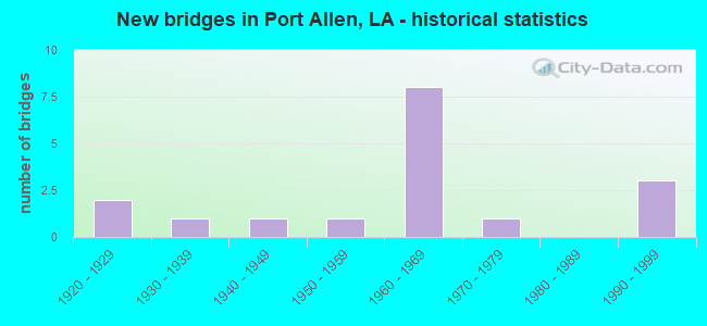
- New bridges - historical statistics
- 21920-1929
- 11930-1939
- 11940-1949
- 11950-1959
- 81960-1969
- 11970-1979
- 31990-1999


- Bridge Condition - Deck
- 37.5%Good
- 37.5%Satisfactory
- 25.0%Fair

- Bridge Condition - Superstructure
- 25.0%Very good
- 12.5%Good
- 12.5%Satisfactory
- 25.0%Fair
- 12.5%Poor
- 12.5%Serious

- Bridge Condition - Substructure
- 37.5%Good
- 12.5%Satisfactory
- 25.0%Fair
- 12.5%Poor
- 12.5%Serious

- Bridge Condition - Channel
- 33.3%Good
- 50.0%Satisfactory
- 8.3%Fair
- 8.3%Poor

- Bridge Condition - Culverts
- 77.8%Good
- 22.2%Satisfactory
Find on map >> Show street view
Structure Number: 616100080102931, Location: 5.20 MI W OF US61 (Lat: 30.493831, Lng: -91.255000), Route carried "on" structure: US 190, Year Built: 1940, Status: Open, Structure Length: 30.33m (99.51ft), Average Daily Traffic: 14,400 (year 2018), Truck Traffic: 9%, Average Future Daily Traffic: 7,320 (year 2036), Design Load: H 15, Features Intersected: LA 415/M P RR @ LOBDELL
Minimum Vertical Clearance: 30+ m (98+ ft), Kilometerpoint: 4.733, Lanes on structure: 4, Lanes under structure: 3, Base Highway Network: Yes (Inventory Route: 8-01-1, Subroute: 10), Owner: State Highway Agency, Approaching Roadway Width: 21.3m (69.9ft), Skew: 30 degrees, Material/Design: Steel, Design/Construction: Stringer/Multi-beam, Number Of Spans In Main Unit: 5, Number Of Approach Spans: 20, Length of Maximum Span: 19.5m (64.0ft), Curb-To-Curb Width: 14.5m (47.6ft), Out-to-Out Width: 16.8m (55.1ft)
Condition: Deck: Fair, Superstructure: Serious, Substructure: Poor, Operating Rating: 36.6 metric tons, Method Used To Determine Operating Rating: Load and Resistance Factor Rating (LRFR) rating reported by rating factor(RF) method using HL-93 loadings, Inventory Rating: 28.5 metric tons, Method Used To Determine Inventory Rating: Load and Resistance Factor Rating (LRFR) rating reported by rating factor(RF) method using HL-93 loadings, Structural Evaluation: High priority of corrective action, Deck Geometry: High priority of replacement, Underclear: Meets minimum limits, Approach Roadway Alignment: Equal to present desirable criteria, Length Of Structure Improvement: 30.48m (100.00ft), Designated Inspection Frequency: Every 12 months, Inspection Date: October 2021, Bridge Improvement Cost: $3,094,000, Total Project Cost: $4,641,000 ( Estimate for 2016), Deck Structure Type: Concrete Cast-file-Place, Wearing Surface/Protective System: Wearing Surface: Monolithic Concrete
Find on map >> Show street view
Structure Number: 616100130100931, Location: ROUTE LA 415 (Lat: 30.482881, Lng: -91.250850), Route carried "on" structure: State highway 415, Year Built: 1994, Status: Open, Structure Length: 43.07m (141.31ft), Average Daily Traffic: 10,350 (year 2016), Truck Traffic: 9%, Average Future Daily Traffic: 12,060 (year 2036), Design Load: HS 20, Features Intersected: BRIDGES OVER MO PAC RR
Minimum Vertical Clearance: 30+ m (98+ ft), Kilometerpoint: 1.651, Lanes on structure: 2, Base Highway Network: Yes (Inventory Route: 13-01-1, Subroute: 10), Owner: State Highway Agency, Approaching Roadway Width: 0.3m (1.0ft), Material/Design: Prestressed concrete continuous, Design/Construction: Stringer/Multi-beam, Number Of Spans In Main Unit: 21, Length of Maximum Span: 25.6m (84.0ft), Curb-To-Curb Width: 12.2m (40.0ft), Out-to-Out Width: 12.8m (42.0ft)
Condition: Deck: Good, Superstructure: Very good, Substructure: Good, Operating Rating: 57.1 metric tons, Method Used To Determine Operating Rating: Load Factor (LF), Inventory Rating: 33.6 metric tons, Method Used To Determine Inventory Rating: Load Factor (LF), Structural Evaluation: Better than present minimum criteria, Deck Geometry: Better than present minimum criteria, Underclear: High priority of replacement, Approach Roadway Alignment: Equal to present desirable criteria, Length Of Structure Improvement: 43.07m (141.31ft), Designated Inspection Frequency: Every 24 months, Inspection Date: June 2021, Bridge Improvement Cost: $3,673,000, Total Project Cost: $5,509,000 ( Estimate for 2016), Deck Structure Type: Other
Find on map >> Show street view
Structure Number: 616100130100932, Location: ROUTE LA 415 (Lat: 30.482889, Lng: -91.250631), Route carried "on" structure: State highway 415, Year Built: 1994, Status: Open, Structure Length: 43.07m (141.31ft), Average Daily Traffic: 10,350 (year 2016), Truck Traffic: 9%, Average Future Daily Traffic: 12,060 (year 2036), Design Load: HS 20, Features Intersected: BRIDES OVER MO PAC RR
Minimum Vertical Clearance: 30+ m (98+ ft), Kilometerpoint: 7.326, Lanes on structure: 2, Base Highway Network: Yes (Inventory Route: 13-01-2, Subroute: 10), Owner: State Highway Agency, Approaching Roadway Width: 0.3m (1.0ft), Material/Design: Prestressed concrete continuous, Design/Construction: Stringer/Multi-beam, Number Of Spans In Main Unit: 21, Length of Maximum Span: 25.6m (84.0ft), Curb-To-Curb Width: 12.2m (40.0ft), Out-to-Out Width: 12.8m (42.0ft)
Condition: Deck: Good, Superstructure: Very good, Substructure: Good, Operating Rating: 57.1 metric tons, Method Used To Determine Operating Rating: Load Factor (LF), Inventory Rating: 33.6 metric tons, Method Used To Determine Inventory Rating: Load Factor (LF), Structural Evaluation: Better than present minimum criteria, Deck Geometry: Better than present minimum criteria, Approach Roadway Alignment: Equal to present desirable criteria, Designated Inspection Frequency: Every 24 months, Inspection Date: June 2021, Deck Structure Type: Steel plate, Wearing Surface/Protective System: Wearing Surface: Bituminous
Find on map >> Show street view
Structure Number: 616100130102231, Location: 0.2 M N of LA 415@LA 413 (Lat: 30.465089, Lng: -91.249761), Route carried "on" structure: State highway 415, Year Built: 1926, Year Reconstructed: 1990, Status: Open, Structure Length: 2.59m (8.50ft), Average Daily Traffic: 20,700 (year 2016), Truck Traffic: 9%, Average Future Daily Traffic: 12,060 (year 2036), Design Load: H 15, Features Intersected: STREAM NO NAME
Minimum Vertical Clearance: 30+ m (98+ ft), Kilometerpoint: 3.615, Lanes on structure: 4, Base Highway Network: Yes (Inventory Route: 13-01-1, Subroute: 10), Owner: State Highway Agency, Approaching Roadway Width: 16.8m (55.1ft), Material/Design: Concrete, Design/Construction: Culvert, Number Of Spans In Main Unit: 5, Length of Maximum Span: 1.8m (5.9ft), Curb-To-Curb Width: 24.4m (80.1ft), Out-to-Out Width: 24.4m (80.1ft)
Condition: Channel: Satisfactory, Culverts: Good, Operating Rating: 42.1 metric tons, Method Used To Determine Operating Rating: Load and Resistance Factor Rating (LRFR) rating reported by rating factor(RF) method using HL-93 loadings, Inventory Rating: 32.4 metric tons, Method Used To Determine Inventory Rating: Load and Resistance Factor Rating (LRFR) rating reported by rating factor(RF) method using HL-93 loadings, Structural Evaluation: Better than present minimum criteria, Deck Geometry: Superior to present desirable criteria, Waterway Adequacy: Equal to present desirable criteria, Approach Roadway Alignment: Equal to present desirable criteria, Designated Inspection Frequency: Every 24 months, Inspection Date: June 2021, Deck Structure Type: Concrete Cast-file-Place
Find on map >> Show street view
Structure Number: 616100130104371, Location: 0.9 M W of LA 1@LA 76 (Lat: 30.451469, Lng: -91.226769), Route carried "on" structure: State highway 76, Year Built: 1930, Status: Posted for load, Structure Length: 2.80m (9.19ft), Average Daily Traffic: 6,500 (year 2016), Truck Traffic: 11%, Average Future Daily Traffic: 7,150 (year 2036), Design Load: H 15, Features Intersected: STREAM NO NAME
Minimum Vertical Clearance: 30+ m (98+ ft), Kilometerpoint: 6.663, Lanes on structure: 2, Owner: State Highway Agency, Approaching Roadway Width: 8.8m (28.9ft), Material/Design: Concrete, Design/Construction: Tee Beam, Number Of Spans In Main Unit: 3, Length of Maximum Span: 9.1m (29.9ft), Curb-To-Curb Width: 7.3m (24.0ft), Out-to-Out Width: 8.3m (27.2ft)
Condition: Deck: Satisfactory, Superstructure: Fair, Substructure: Serious, Channel: Poor, Operating Rating: 21.1 metric tons, Method Used To Determine Operating Rating: Load and Resistance Factor Rating (LRFR) rating reported by rating factor(RF) method using HL-93 loadings, Inventory Rating: 16.2 metric tons, Method Used To Determine Inventory Rating: Load and Resistance Factor Rating (LRFR) rating reported by rating factor(RF) method using HL-93 loadings, Structural Evaluation: High priority of corrective action, Deck Geometry: High priority of replacement, Waterway Adequacy: Equal to present minimum criteria, Approach Roadway Alignment: Better than present minimum criteria, Bridge Posting: Required (Relationship of Operating Rating to Maximum Legal Load: 30.0 - 39.9% below), Length Of Structure Improvement: 3.63m (11.91ft), Designated Inspection Frequency: Every 24 months, Other Special Inspection Frequency: Every 12 months, Inspection Date: May 2021, Other Special Inspection Date: November 2020, Bridge Improvement Cost: $309,000, Total Project Cost: $463,000 ( Estimate for 2016), Deck Structure Type: Concrete Cast-file-Place, Wearing Surface/Protective System: Wearing Surface: Monolithic Concrete
Find on map >> Show street view
Structure Number: 616102280610401, Location: 1.1 M W of LA 415@LA 76 (Lat: 30.468050, Lng: -91.270981), Route carried "on" structure: State highway 76, Year Built: 1952, Status: Open, Structure Length: 0.73m (2.40ft), Average Daily Traffic: 4,700 (year 2016), Truck Traffic: 11%, Average Future Daily Traffic: 2,880 (year 2036), Design Load: H 15, Features Intersected: STREAM NO NAME
Minimum Vertical Clearance: 30+ m (98+ ft), Kilometerpoint: 16.932, Lanes on structure: 2, Owner: State Highway Agency, Approaching Roadway Width: 9.8m (32.2ft), Material/Design: Concrete, Design/Construction: Culvert, Number Of Spans In Main Unit: 3, Length of Maximum Span: 2.1m (6.9ft), Curb-To-Curb Width: 9.8m (32.2ft), Out-to-Out Width: 10.4m (34.1ft)
Condition: Channel: Satisfactory, Culverts: Good, Operating Rating: 42.1 metric tons, Method Used To Determine Operating Rating: Load and Resistance Factor Rating (LRFR) rating reported by rating factor(RF) method using HL-93 loadings, Inventory Rating: 32.4 metric tons, Method Used To Determine Inventory Rating: Load and Resistance Factor Rating (LRFR) rating reported by rating factor(RF) method using HL-93 loadings, Structural Evaluation: Better than present minimum criteria, Deck Geometry: Meets minimum limits, Waterway Adequacy: Equal to present desirable criteria, Approach Roadway Alignment: Equal to present minimum criteria, Designated Inspection Frequency: Every 24 months, Inspection Date: December 2020, Deck Structure Type: Concrete Cast-file-Place
Find on map >> Show street view
Structure Number: 616102280611741, Location: ROUTE LA 76 W STA 48 & 62 (Lat: 30.461331, Lng: -91.250211), Route carried "on" structure: State highway 76, Year Built: 1990, Status: Open, Structure Length: 2.93m (9.61ft), Average Daily Traffic: 4,700 (year 2016), Truck Traffic: 11%, Average Future Daily Traffic: 2,880 (year 2036), Design Load: HS 20, Features Intersected: DRAIN
Minimum Vertical Clearance: 30+ m (98+ ft), Kilometerpoint: 18.979, Lanes on structure: 2, Owner: State Highway Agency, Approaching Roadway Width: 17.1m (56.1ft), Material/Design: Concrete, Design/Construction: Culvert, Length of Maximum Span: 0.0m
Condition: Channel: Good, Culverts: Good, Operating Rating: 42.1 metric tons, Method Used To Determine Operating Rating: Load and Resistance Factor Rating (LRFR) rating reported by rating factor(RF) method using HL-93 loadings, Inventory Rating: 32.4 metric tons, Method Used To Determine Inventory Rating: Load and Resistance Factor Rating (LRFR) rating reported by rating factor(RF) method using HL-93 loadings, Structural Evaluation: Better than present minimum criteria, Waterway Adequacy: Equal to present desirable criteria, Approach Roadway Alignment: Equal to present desirable criteria, Designated Inspection Frequency: Every 24 months, Inspection Date: June 2021, Deck Structure Type: Concrete Cast-file-Place
Find on map >> Show street view
Structure Number: 616102280700621, Location: 0.6 M E of LA 415@LA 986 (Lat: 30.461969, Lng: -91.239250), Route carried "on" structure: State highway 986, Year Built: 1923, Status: Open, Structure Length: 0.70m (2.30ft), Average Daily Traffic: 1,220 (year 2016), Truck Traffic: 11%, Average Future Daily Traffic: 492 (year 2036), Design Load: H 15, Features Intersected: DRAINAGE CANAL
Minimum Vertical Clearance: 30+ m (98+ ft), Kilometerpoint: 1.012, Lanes on structure: 2, Owner: State Highway Agency, Approaching Roadway Width: 7.9m (25.9ft), Material/Design: Concrete, Design/Construction: Culvert, Number Of Spans In Main Unit: 5, Length of Maximum Span: 1.2m (3.9ft), Curb-To-Curb Width: 7.3m (24.0ft), Out-to-Out Width: 7.3m (24.0ft)
Condition: Channel: Good, Culverts: Good, Operating Rating: 22.7 metric tons, Method Used To Determine Operating Rating: Load and Resistance Factor Rating (LRFR) rating reported by rating factor(RF) method using HL-93 loadings, Inventory Rating: 17.5 metric tons, Method Used To Determine Inventory Rating: Load and Resistance Factor Rating (LRFR) rating reported by rating factor(RF) method using HL-93 loadings, Structural Evaluation: Meets minimum limits, Deck Geometry: Meets minimum limits, Waterway Adequacy: High priority of corrective action, Approach Roadway Alignment: Equal to present desirable criteria, Length Of Structure Improvement: 1.31m (4.30ft), Designated Inspection Frequency: Every 24 months, Inspection Date: July 2021, Bridge Improvement Cost: $111,000, Total Project Cost: $166,000 ( Estimate for 2016), Deck Structure Type: Concrete Cast-file-Place
Find on map >> Show street view
Structure Number: 616102280701541, Location: 0.72 M W of LA 986&LA 1 (Lat: 30.462669, Lng: -91.224139), Route carried "on" structure: State highway 986, Year Built: 1969, Status: Posted for load, Structure Length: 1.74m (5.71ft), Average Daily Traffic: 1,220 (year 2016), Truck Traffic: 11%, Average Future Daily Traffic: 492 (year 2036), Design Load: H 15, Features Intersected: CHOCTAW BAYOU
Minimum Vertical Clearance: 30+ m (98+ ft), Kilometerpoint: 2.469, Lanes on structure: 2, Owner: State Highway Agency, Approaching Roadway Width: 10.1m (33.1ft), Material/Design: Concrete, Design/Construction: Slab, Number Of Spans In Main Unit: 3, Length of Maximum Span: 5.8m (19.0ft), Curb-To-Curb Width: 7.4m (24.3ft), Out-to-Out Width: 8.3m (27.2ft)
Condition: Deck: Fair, Superstructure: Fair, Substructure: Fair, Channel: Satisfactory, Operating Rating: 18.8 metric tons, Method Used To Determine Operating Rating: Load and Resistance Factor Rating (LRFR) rating reported by rating factor(RF) method using HL-93 loadings, Inventory Rating: 14.6 metric tons, Method Used To Determine Inventory Rating: Load and Resistance Factor Rating (LRFR) rating reported by rating factor(RF) method using HL-93 loadings, Structural Evaluation: Meets minimum limits, Deck Geometry: Meets minimum limits, Waterway Adequacy: Somewhat better than minimum adequacy, Approach Roadway Alignment: Equal to present desirable criteria, Bridge Posting: Required (Relationship of Operating Rating to Maximum Legal Load: 20.0 - 29.9% below), Designated Inspection Frequency: Every 24 months, Inspection Date: July 2021, Deck Structure Type: Concrete Precast Panels, Wearing Surface/Protective System: Wearing Surface: Bituminous
Find on map >> Show street view
Structure Number: 616104500803831, Location: I0010 (Lat: 30.443100, Lng: -91.347319), Route carried "on" structure: Interstate 10, Year Built: 1974, Status: Open, Structure Length: 7.32m (24.02ft), Average Daily Traffic: 31,450 (year 2016), Truck Traffic: 28%, Average Future Daily Traffic: 25,200 (year 2036), Design Load: HS 20, Features Intersected: BAYOU CHOCTAW
Minimum Vertical Clearance: 30+ m (98+ ft), Kilometerpoint: 6.112, Lanes on structure: 2, Base Highway Network: Yes (Inventory Route: 450-08-1, Subroute: 10), Owner: State Highway Agency, Approaching Roadway Width: 15.2m (49.9ft), Skew: 10 degrees, Material/Design: Prestressed concrete, Design/Construction: Stringer/Multi-beam, Number Of Spans In Main Unit: 5, Length of Maximum Span: 14.6m (47.9ft), Curb-To-Curb Width: 12.2m (40.0ft), Out-to-Out Width: 12.9m (42.3ft)
Condition: Deck: Good, Superstructure: Good, Substructure: Satisfactory, Channel: Good, Operating Rating: 51.2 metric tons, Method Used To Determine Operating Rating: Load and Resistance Factor Rating (LRFR) rating reported by rating factor(RF) method using HL-93 loadings, Inventory Rating: 33.0 metric tons, Method Used To Determine Inventory Rating: Load and Resistance Factor Rating (LRFR) rating reported by rating factor(RF) method using HL-93 loadings, Structural Evaluation: Equal to present minimum criteria, Deck Geometry: Better than present minimum criteria, Waterway Adequacy: Equal to present desirable criteria, Approach Roadway Alignment: Equal to present desirable criteria, Designated Inspection Frequency: Every 24 months, Underwater Inspection Frequency: Every 60 months, Inspection Date: Febuary 2020, Underwater Inspection Date: April 2019, Deck Structure Type: Concrete Cast-file-Place, Wearing Surface/Protective System: Wearing Surface: Monolithic Concrete
Find on map >> Show street view
Structure Number: 616104500809751, Location: 0.51 M W of LA 415&I-10 (Lat: 30.448731, Lng: -91.250619), Route carried "on" structure: Interstate 10, Year Built: 1969, Status: Open, Structure Length: 1.43m (4.69ft), Average Daily Traffic: 62,900 (year 2016), Truck Traffic: 28%, Average Future Daily Traffic: 42,000 (year 2036), Design Load: HS 20, Features Intersected: DRAINAGE CANAL
Minimum Vertical Clearance: 30+ m (98+ ft), Kilometerpoint: 15.627, Lanes on structure: 6, Base Highway Network: Yes (Inventory Route: 450-08-1, Subroute: 10), Owner: State Highway Agency, Approaching Roadway Width: 31.1m (102.0ft), Skew: 14 degrees, Material/Design: Concrete, Design/Construction: Culvert, Number Of Spans In Main Unit: 3, Length of Maximum Span: 3.0m (9.8ft), Curb-To-Curb Width: 31.1m (102.0ft), Out-to-Out Width: 123.4m (404.9ft)
Condition: Channel: Satisfactory, Culverts: Good, Operating Rating: 42.1 metric tons, Method Used To Determine Operating Rating: Load and Resistance Factor Rating (LRFR) rating reported by rating factor(RF) method using HL-93 loadings, Inventory Rating: 32.4 metric tons, Method Used To Determine Inventory Rating: Load and Resistance Factor Rating (LRFR) rating reported by rating factor(RF) method using HL-93 loadings, Structural Evaluation: Better than present minimum criteria, Deck Geometry: Superior to present desirable criteria, Waterway Adequacy: Equal to present desirable criteria, Approach Roadway Alignment: Equal to present desirable criteria, Designated Inspection Frequency: Every 24 months, Inspection Date: January 2020, Deck Structure Type: Concrete Cast-file-Place
Find on map >> Show street view
Structure Number: 616104500810111, Location: I0010 (Lat: 30.447600, Lng: -91.245919), Route carried "on" structure: Interstate 10, Year Built: 1969, Status: Open, Structure Length: 29.44m (96.59ft), Average Daily Traffic: 31,450 (year 2016), Truck Traffic: 9%, Average Future Daily Traffic: 25,200 (year 2036), Design Load: HS 20, Features Intersected: I-10 OVER LA 415-WESTOVE
Minimum Vertical Clearance: 30+ m (98+ ft), Kilometerpoint: 16.082, Lanes on structure: 2, Lanes under structure: 4, Base Highway Network: Yes (Inventory Route: 450-08-1, Subroute: 10), Owner: State Highway Agency, Approaching Roadway Width: 20.1m (65.9ft), Skew: 12 degrees, Material/Design: Prestressed concrete, Design/Construction: Stringer/Multi-beam, Number Of Spans In Main Unit: 13, Length of Maximum Span: 34.1m (111.9ft), Curb-To-Curb Width: 12.0m (39.4ft), Out-to-Out Width: 13.0m (42.7ft)
Condition: Deck: Satisfactory, Superstructure: Satisfactory, Substructure: Good, Operating Rating: 78.9 metric tons, Method Used To Determine Operating Rating: Load Factor (LF), Inventory Rating: 47.2 metric tons, Method Used To Determine Inventory Rating: Load Factor (LF), Structural Evaluation: Equal to present minimum criteria, Deck Geometry: Equal to present minimum criteria, Underclear: Equal to present minimum criteria, Approach Roadway Alignment: Equal to present desirable criteria, Designated Inspection Frequency: Every 24 months, Inspection Date: July 2021, Deck Structure Type: Concrete Cast-file-Place, Wearing Surface/Protective System: Wearing Surface: Monolithic Concrete
Find on map >> Show street view
Structure Number: 616104500810112, Location: I0010 (Lat: 30.447839, Lng: -91.245839), Route carried "on" structure: Interstate 10, Year Built: 1969, Status: Open, Structure Length: 29.35m (96.29ft), Average Daily Traffic: 31,450 (year 2016), Truck Traffic: 9%, Average Future Daily Traffic: 25,200 (year 2036), Design Load: HS 20, Features Intersected: I-10 OVER LA 415-WESTOVE
Minimum Vertical Clearance: 30+ m (98+ ft), Kilometerpoint: 3.842, Lanes on structure: 2, Lanes under structure: 4, Base Highway Network: Yes (Inventory Route: 450-08-2, Subroute: 10), Owner: State Highway Agency, Approaching Roadway Width: 20.1m (65.9ft), Skew: 12 degrees, Material/Design: Prestressed concrete, Design/Construction: Stringer/Multi-beam, Number Of Spans In Main Unit: 13, Length of Maximum Span: 32.3m (106.0ft), Curb-To-Curb Width: 12.0m (39.4ft), Out-to-Out Width: 13.0m (42.7ft)
Condition: Deck: Satisfactory, Superstructure: Poor, Substructure: Fair, Operating Rating: 45.0 metric tons, Method Used To Determine Operating Rating: Load and Resistance Factor Rating (LRFR) rating reported by rating factor(RF) method using HL-93 loadings, Inventory Rating: 26.6 metric tons, Method Used To Determine Inventory Rating: Load and Resistance Factor Rating (LRFR) rating reported by rating factor(RF) method using HL-93 loadings, Structural Evaluation: Meets minimum limits, Deck Geometry: Equal to present minimum criteria, Underclear: Equal to present minimum criteria, Approach Roadway Alignment: Equal to present desirable criteria, Designated Inspection Frequency: Every 12 months, Inspection Date: July 2021, Deck Structure Type: Concrete Cast-file-Place, Wearing Surface/Protective System: Wearing Surface: Monolithic Concrete
Find on map >> Show street view
Structure Number: 616104500810901, Location: 0.92 M E of LA 415&I-10 (Lat: 30.445481, Lng: -91.231311), Route carried "on" structure: Interstate 10, Year Built: 1969, Status: Open, Structure Length: 1.07m (3.51ft), Average Daily Traffic: 72,300 (year 2016), Truck Traffic: 9%, Average Future Daily Traffic: 39,900 (year 2036), Design Load: HS 20, Features Intersected: DRAINAGE CANAL
Minimum Vertical Clearance: 30+ m (98+ ft), Kilometerpoint: 2.676, Lanes on structure: 4, Base Highway Network: Yes (Inventory Route: 450-08-2, Subroute: 10), Owner: State Highway Agency, Approaching Roadway Width: 23.2m (76.1ft), Skew: 16 degrees, Material/Design: Concrete, Design/Construction: Culvert, Number Of Spans In Main Unit: 3, Length of Maximum Span: 3.0m (9.8ft), Curb-To-Curb Width: 23.2m (76.1ft), Out-to-Out Width: 75.9m (249.0ft)
Condition: Channel: Good, Culverts: Satisfactory, Operating Rating: 42.1 metric tons, Method Used To Determine Operating Rating: Load and Resistance Factor Rating (LRFR) rating reported by rating factor(RF) method using HL-93 loadings, Inventory Rating: 32.4 metric tons, Method Used To Determine Inventory Rating: Load and Resistance Factor Rating (LRFR) rating reported by rating factor(RF) method using HL-93 loadings, Structural Evaluation: Equal to present minimum criteria, Deck Geometry: Superior to present desirable criteria, Waterway Adequacy: Equal to present desirable criteria, Approach Roadway Alignment: Equal to present desirable criteria, Designated Inspection Frequency: Every 24 months, Inspection Date: July 2021, Deck Structure Type: Concrete Cast-file-Place
Find on map >> Show street view
Structure Number: 616108610600371, Location: 0.4 MILES EAST OF HWY 415 (Lat: 30.477719, Lng: -91.244361), Route carried "on" structure: State highway 9873, Year Built: 1962, Status: Open, Structure Length: 0.79m (2.59ft), Average Daily Traffic: 1,310 (year 2016), Truck Traffic: 11%, Average Future Daily Traffic: 810 (year 2036), Design Load: H 15, Features Intersected: DRAINAGE CANAL
Minimum Vertical Clearance: 30+ m (98+ ft), Kilometerpoint: 0.621, Lanes on structure: 2, Owner: State Highway Agency, Approaching Roadway Width: 10.7m (35.1ft), Skew: 8 degrees, Material/Design: Steel, Design/Construction: Culvert, Number Of Spans In Main Unit: 2, Length of Maximum Span: 3.4m (11.2ft), Curb-To-Curb Width: 6.1m (20.0ft), Out-to-Out Width: 11.8m (38.7ft)
Condition: Channel: Satisfactory, Culverts: Good, Operating Rating: 97.2 metric tons, Method Used To Determine Operating Rating: Load and Resistance Factor Rating (LRFR) rating reported by rating factor(RF) method using HL-93 loadings, Inventory Rating: 74.5 metric tons, Method Used To Determine Inventory Rating: Load and Resistance Factor Rating (LRFR) rating reported by rating factor(RF) method using HL-93 loadings, Structural Evaluation: Better than present minimum criteria, Deck Geometry: High priority of replacement, Waterway Adequacy: Equal to present desirable criteria, Approach Roadway Alignment: Equal to present desirable criteria, Designated Inspection Frequency: Every 24 months, Inspection Date: June 2021
Find on map >> Show street view
Structure Number: 616108610601701, Location: 1.7 MILES EAST OF HWY 415 (Lat: 30.475131, Lng: -91.222631), Route carried "on" structure: State highway 9873, Year Built: 1962, Status: Open, Structure Length: 0.94m (3.08ft), Average Daily Traffic: 1,310 (year 2016), Truck Traffic: 11%, Average Future Daily Traffic: 810 (year 2036), Design Load: H 15, Features Intersected: DRAINAGE CANAL
Minimum Vertical Clearance: 30+ m (98+ ft), Kilometerpoint: 2.744, Lanes on structure: 2, Owner: State Highway Agency, Approaching Roadway Width: 11.6m (38.1ft), Material/Design: Steel, Design/Construction: Culvert, Number Of Spans In Main Unit: 2, Length of Maximum Span: 4.3m (14.1ft), Curb-To-Curb Width: 6.1m (20.0ft), Out-to-Out Width: 11.8m (38.7ft)
Condition: Channel: Satisfactory, Culverts: Satisfactory, Operating Rating: 97.2 metric tons, Method Used To Determine Operating Rating: Load and Resistance Factor Rating (LRFR) rating reported by rating factor(RF) method using HL-93 loadings, Inventory Rating: 74.5 metric tons, Method Used To Determine Inventory Rating: Load and Resistance Factor Rating (LRFR) rating reported by rating factor(RF) method using HL-93 loadings, Structural Evaluation: Equal to present minimum criteria, Deck Geometry: High priority of replacement, Waterway Adequacy: Equal to present desirable criteria, Approach Roadway Alignment: Equal to present desirable criteria, Designated Inspection Frequency: Every 24 months, Inspection Date: June 2021
Find on map >> Show street view
Structure Number: 616108610602151, Location: 2.1 MILES EAST OF HWY 415 (Lat: 30.474711, Lng: -91.214889), Route carried "on" structure: State highway 9873, Year Built: 1962, Status: Open, Structure Length: 0.79m (2.59ft), Average Daily Traffic: 1,310 (year 2016), Truck Traffic: 11%, Average Future Daily Traffic: 810 (year 2036), Design Load: H 15, Features Intersected: DRAINAGE CANAL
Minimum Vertical Clearance: 30+ m (98+ ft), Kilometerpoint: 3.486, Lanes on structure: 2, Owner: State Highway Agency, Approaching Roadway Width: 12.5m (41.0ft), Material/Design: Steel, Design/Construction: Culvert, Number Of Spans In Main Unit: 2, Length of Maximum Span: 3.4m (11.2ft), Curb-To-Curb Width: 6.1m (20.0ft), Out-to-Out Width: 11.8m (38.7ft)
Condition: Channel: Fair, Culverts: Good, Operating Rating: 97.2 metric tons, Method Used To Determine Operating Rating: Load and Resistance Factor Rating (LRFR) rating reported by rating factor(RF) method using HL-93 loadings, Inventory Rating: 74.5 metric tons, Method Used To Determine Inventory Rating: Load and Resistance Factor Rating (LRFR) rating reported by rating factor(RF) method using HL-93 loadings, Structural Evaluation: Better than present minimum criteria, Deck Geometry: High priority of replacement, Waterway Adequacy: Better than present minimum criteria, Approach Roadway Alignment: Equal to present desirable criteria, Designated Inspection Frequency: Every 24 months, Inspection Date: June 2021
Find on map >> Show street view
Structure Number: 616100080102931, Location: 1.2 MI N OF LA 987 (Lat: 30.493619, Lng: -91.255189), Route carried "under" structure: State highway 415, Structure Length: 0. m, Average Daily Traffic: 760 (year 2016), Features Intersected: LA 415 (LOOP RD) UNDER U
Minimum Vertical Clearance: 5.88m (19.29ft), Kilometerpoint: 0.510, Lanes on structure: 4, Lanes under structure: 2, Length of Maximum Span: 0.0m
Find on map >> Show street view
Structure Number: 616100080102931, Location: 1.2 MI N OF LA 987 (Lat: 30.492689, Lng: -91.257381), Route carried "under" structure: State highway 415, Structure Length: 0. m, Average Daily Traffic: 20,700 (year 2016), Features Intersected: LA 415 NB TO US 190 WB U
Minimum Vertical Clearance: 6.07m (19.91ft), Kilometerpoint: 9.125, Lanes on structure: 4, Lanes under structure: 1, Length of Maximum Span: 0.0m
Find on map >> Show street view
Structure Number: 616100500708321, Location: 1.3 MI S OF LA 76 (Lat: 30.433800, Lng: -91.209881), Route carried "under" structure: ServiceState highway 1, Structure Length: 0. m, Average Daily Traffic: 3,820 (year 2016), Features Intersected: LA 1 NB SERVICE RD UNDER
Minimum Vertical Clearance: 10.85m (35.60ft), Kilometerpoint: 0.335, Lanes on structure: 2, Lanes under structure: 1, Length of Maximum Span: 0.0m
Find on map >> Show street view
Structure Number: 616100500708321, Location: 1.5 MI S OF LA 76 (Lat: 30.429669, Lng: -91.212731), Route carried "under" structure: ServiceState highway 1, Structure Length: 0. m, Average Daily Traffic: 3,820 (year 2016), Features Intersected: LA 1 NB SERVICE RD UNDER
Minimum Vertical Clearance: 5.12m (16.80ft), Kilometerpoint: 13.375, Lanes on structure: 2, Lanes under structure: 1, Length of Maximum Span: 0.0m
Find on map >> Show street view
Structure Number: 616100500708321, Location: 1.3 MI S OF LA 76 (Lat: 30.433789, Lng: -91.209731), Route carried "under" structure: Ramp State highway 1, Structure Length: 0. m, Average Daily Traffic: 3,820 (year 2016), Features Intersected: LA 1 SB ON RAMP FROM SER
Minimum Vertical Clearance: 10.73m (35.20ft), Kilometerpoint: 0.032, Lanes on structure: 2, Lanes under structure: 1, Length of Maximum Span: 0.0m
Find on map >> Show street view
Structure Number: 616100500708321, Location: 1.5 MI S OF LA 76 (Lat: 30.429681, Lng: -91.212831), Route carried "under" structure: Ramp State highway 1, Structure Length: 0. m, Average Daily Traffic: 3,820 (year 2016), Features Intersected: LA 1 SB OFF RAMP TO LA 1
Minimum Vertical Clearance: 5.03m (16.50ft), Kilometerpoint: 0.047, Lanes on structure: 2, Lanes under structure: 1, Length of Maximum Span: 0.0m
Find on map >> Show street view
Structure Number: 616100500708322, Location: 1.3 MI S OF LA 76 (Lat: 30.433881, Lng: -91.209981), Route carried "under" structure: ServiceState highway 1, Structure Length: 0. m, Average Daily Traffic: 3,820 (year 2016), Features Intersected: LA 1 NB SERVICE RD UNDER
Minimum Vertical Clearance: 10.73m (35.20ft), Kilometerpoint: 0.322, Lanes on structure: 2, Lanes under structure: 1, Length of Maximum Span: 0.0m
Find on map >> Show street view
Structure Number: 616100500708322, Location: 1.3 MI S OF LA 76 (Lat: 30.433869, Lng: -91.209881), Route carried "under" structure: Ramp State highway 1, Structure Length: 0. m, Average Daily Traffic: 3,820 (year 2016), Features Intersected: LA 1 SB ON RAMP FROM SER
Minimum Vertical Clearance: 10.67m (35.01ft), Kilometerpoint: 0.050, Lanes on structure: 2, Lanes under structure: 1, Length of Maximum Span: 0.0m
Find on map >> Show street view
Structure Number: 616100500708322, Location: 1.5 MI S OF LA 76 (Lat: 30.429761, Lng: -91.212969), Route carried "under" structure: Ramp State highway 1, Structure Length: 0. m, Average Daily Traffic: 3,820 (year 2016), Features Intersected: LA 1 SB OFF RAMP TO LA 1
Minimum Vertical Clearance: 5.12m (16.80ft), Kilometerpoint: 0.031, Lanes on structure: 2, Lanes under structure: 1, Length of Maximum Span: 0.0m
Find on map >> Show street view
Structure Number: 616100500708322, Location: 1.5 MI S OF LA 76 (Lat: 30.429750, Lng: -91.212861), Route carried "under" structure: ServiceState highway 1, Structure Length: 0. m, Average Daily Traffic: 3,820 (year 2016), Features Intersected: LA 1 NB SERVICE RD UNDER
Minimum Vertical Clearance: 5.27m (17.29ft), Kilometerpoint: 13.391, Lanes on structure: 2, Lanes under structure: 1, Length of Maximum Span: 0.0m
Find on map >> Show street view
Structure Number: 616104500810111, Location: 0.24 MI. S. OF LA 76 (Lat: 30.447281, Lng: -91.244389), Route carried "under" structure: State highway 415, Structure Length: 0. m, Average Daily Traffic: 22,200 (year 2014), Features Intersected: LA 415 SB UNDER I-10 EB
Minimum Vertical Clearance: 4.79m (15.72ft), Kilometerpoint: 0.396, Lanes on structure: 2, Length of Maximum Span: 0.0m
Find on map >> Show street view
Structure Number: 616104500810111, Location: 0.24 MI. S OF LA 76 (Lat: 30.447081, Lng: -91.244100), Route carried "under" structure: State highway 415, Structure Length: 0. m, Average Daily Traffic: 22,200 (year 2014), Features Intersected: LA 415 NB UNDER I-10 EB
Minimum Vertical Clearance: 4.69m (15.39ft), Kilometerpoint: 0.209, Lanes on structure: 2, Length of Maximum Span: 0.0m
Find on map >> Show street view
Structure Number: 616104500812101, Location: 0.04 MILES WEST OF LA 1 (Lat: 30.440311, Lng: -91.209281), Route carried "under" structure: Ramp Interstate 10, Structure Length: 0. m, Average Daily Traffic: 6,650 (year 2016), Features Intersected: I-10 WEST OFF RAMP TO LA
Minimum Vertical Clearance: 9.91m (32.51ft), Kilometerpoint: 0.352, Lanes on structure: 1, Length of Maximum Span: 0.0m
Find on map >> Show street view
Structure Number: 616104500812101, Location: 0.246 MI S OF LA.1 (Lat: 30.440319, Lng: -91.209711), Route carried "under" structure: Ramp Interstate 10, Structure Length: 0. m, Average Daily Traffic: 6,650 (year 2016), Features Intersected: I-10 WEST OF RAMP UNDER
Minimum Vertical Clearance: 7.77m (25.49ft), Kilometerpoint: 0.401, Lanes on structure: 1, Length of Maximum Span: 0.0m
Find on map >> Show street view
Structure Number: 616104500812101, Location: 0.246 MI S OF LA.1 (Lat: 30.440331, Lng: -91.209789), Route carried "under" structure: Ramp Interstate 10, Structure Length: 0. m, Average Daily Traffic: 6,650 (year 2016), Features Intersected: I-10 EAST ON RAMP TO POR
Minimum Vertical Clearance: 7.74m (25.39ft), Kilometerpoint: 0.156, Lanes on structure: 1, Length of Maximum Span: 0.0m
Find on map >> Show street view
Structure Number: 616104500812101, Location: 0.217 MI S OF LA 1 (Lat: 30.440339, Lng: -91.209981), Route carried "under" structure: Ramp Interstate 10, Structure Length: 0. m, Average Daily Traffic: 6,650 (year 2016), Features Intersected: I-10 E ON RAMP UNDER I-1
Minimum Vertical Clearance: 8.75m (28.71ft), Kilometerpoint: 0.465, Lanes on structure: 1, Length of Maximum Span: 0.0m
Find on map >> Show street view
Structure Number: 616104500812101, Location: 0.04 MI N OF I-10 SRV RD (Lat: 30.440181, Lng: -91.210389), Route carried "under" structure: ServiceState highway 1, Structure Length: 0. m, Average Daily Traffic: 4,920 (year 2015), Features Intersected: LA 1 SERVICE RD/LEBLANC
Minimum Vertical Clearance: 7.35m (24.11ft), Kilometerpoint: 0.686, Lanes on structure: 2, Length of Maximum Span: 0.0m
Find on map >> Show street view
Structure Number: 616104500812101, Location: .01 MI W OF LA 1 N (Lat: 30.440281, Lng: -91.208631), Route carried "under" structure: State highway 1, Structure Length: 0. m, Average Daily Traffic: 49,200 (year 2015), Features Intersected: LA 1 SOUTH UNDER I-10
Minimum Vertical Clearance: 11.43m (37.50ft), Kilometerpoint: 7.331, Lanes on structure: 2, Length of Maximum Span: 0.0m
Find on map >> Show street view
Structure Number: 616104500812101, Location: 0.09 MI E OF LA 1 N (Lat: 30.439989, Lng: -91.207069), Route carried "under" structure: ServiceState highway 1, Structure Length: 0. m, Average Daily Traffic: 4,920 (year 2015), Features Intersected: LA 1 NORTH BOUND SERVICE
Minimum Vertical Clearance: 16.37m (53.71ft), Kilometerpoint: 0.744, Lanes on structure: 2, Length of Maximum Span: 0.0m
Find on map >> Show street view
Structure Number: 616104500812101, Location: 0.04 MI E OF LA 1 N (Lat: 30.440031, Lng: -91.207831), Route carried "under" structure: Ramp Interstate 10, Structure Length: 0. m, Average Daily Traffic: 6,650 (year 2015), Features Intersected: I-10 EAST OFF RAMP TO LA
Minimum Vertical Clearance: 9.57m (31.40ft), Kilometerpoint: 0.359, Lanes on structure: 1, Length of Maximum Span: 0.0m
Find on map >> Show street view
Structure Number: 616104500812101, Location: 0.01 MI E OF LA 1 N (Lat: 30.440061, Lng: -91.208300), Route carried "under" structure: Ramp Interstate 10, Structure Length: 0. m, Average Daily Traffic: 6,650 (year 2016), Features Intersected: I-1O WEST ON RAMP FROM L
Minimum Vertical Clearance: 11.25m (36.91ft), Kilometerpoint: 1.704, Lanes on structure: 1, Length of Maximum Span: 0.0m
Find on map >> Show street view
Structure Number: 616104500812101, Location: 0.01 MILES E OF LA 1 S (Lat: 30.440061, Lng: -91.208431), Route carried "under" structure: State highway 1, Structure Length: 0. m, Average Daily Traffic: 49,200 (year 2015), Features Intersected: LA 1 NORTH UNDER I-10
Minimum Vertical Clearance: 12.13m (39.80ft), Kilometerpoint: 14.613, Lanes on structure: 2, Length of Maximum Span: 0.0m
Find on map >> Show street view
Structure Number: 616104500812107, Location: 0.03 MI N OF I-10 SRV RD (Lat: 30.439969, Lng: -91.210369), Route carried "under" structure: ServiceState highway 1, Structure Length: 0. m, Average Daily Traffic: 4,920 (year 2015), Features Intersected: LA 1 SERVICE RD/LEBLANC
Minimum Vertical Clearance: 7.16m (23.49ft), Kilometerpoint: 0.708, Lanes on structure: 2, Length of Maximum Span: 0.0m
Find on map >> Show street view
Structure Number: 616104500812186, Location: 0.12 MI N OF I10 SV. RD (Lat: 30.441239, Lng: -91.210489), Route carried "under" structure: ServiceState highway 1, Structure Length: 0. m, Average Daily Traffic: 4,920 (year 2015), Features Intersected: LA 1 SERVICE RD./LEBLANC
Minimum Vertical Clearance: 6.86m (22.51ft), Kilometerpoint: 0.566, Lanes on structure: 2, Length of Maximum Span: 0.0m
Find on map >> Show street view
Structure Number: 616104500812227, Location: 0.279 MI. S. OF LA 1 (Lat: 30.439911, Lng: -91.209661), Route carried "under" structure: Ramp Interstate 10, Structure Length: 0. m, Average Daily Traffic: 6,650 (year 2016), Features Intersected: I-10 EB ON RAMP TO PORT
Minimum Vertical Clearance: 5.91m (19.39ft), Kilometerpoint: 0.354, Lanes on structure: 1, Length of Maximum Span: 7.8m (25.6ft)
Find on map >> Show street view
Structure Number: 616104500812227, Location: 0.273 MI. SOUTH OF LA 1 (Lat: 30.440000, Lng: -91.209969), Route carried "under" structure: Ramp Interstate 10, Structure Length: 0. m, Average Daily Traffic: 6,650 (year 2016), Features Intersected: I-10 E. ON RAMP UNDER I-
Minimum Vertical Clearance: 5.49m (18.01ft), Kilometerpoint: 0.502, Lanes on structure: 1, Length of Maximum Span: 7.8m (25.6ft)
Find on map >> Show street view
Structure Number: 616104500812227, Location: 0.279 Mi S of LA 1 (Lat: 30.439911, Lng: -91.209661), Route carried "under" structure: Ramp Interstate 10, Structure Length: 0. m, Average Daily Traffic: 6,650 (year 2016), Features Intersected: LA 1 SB Off-Ramp to Port
Minimum Vertical Clearance: 5.91m (19.39ft), Kilometerpoint: 0.151, Lanes on structure: 1, Length of Maximum Span: 7.8m (25.6ft)
Find on map >> Show street view
Structure Number: 616104500812235, Location: .01 MI S. OF I-10 (Lat: 30.438489, Lng: -91.210169), Route carried "under" structure: Ramp Interstate 10, Structure Length: 0. m, Average Daily Traffic: 6,650 (year 2016), Features Intersected: I-10 EB OFF RAMP TO PORT
Minimum Vertical Clearance: 6.61m (21.69ft), Kilometerpoint: 0.072, Lanes on structure: 1, Length of Maximum Span: 0.0m
Find on map >> Show street view
Structure Number: 616104500812235, Location: .01 MI. S. OF I-10 (Lat: 30.438731, Lng: -91.209661), Route carried "under" structure: Ramp Interstate 10, Structure Length: 0. m, Average Daily Traffic: 6,650 (year 2016), Features Intersected: I-10 WB off ramp to port
Minimum Vertical Clearance: 4.91m (16.11ft), Kilometerpoint: 0.224, Lanes on structure: 1, Length of Maximum Span: 0.0m
Find on map >> Show street view
Structure Number: 616104500812235, Location: I-10 OFF RAMP (Lat: 30.438411, Lng: -91.209069), Route carried "under" structure: Ramp Interstate 10, Structure Length: 0. m, Average Daily Traffic: 6,650 (year 2016), Features Intersected: I-10 OFF RAMP UNDER I-10
Minimum Vertical Clearance: 7.68m (25.20ft), Kilometerpoint: 0.713, Lanes on structure: 1, Length of Maximum Span: 0.0m
Find on map >> Show street view
Structure Number: 616104500812235, Location: 1.6 MI N. OF LA 988 (Lat: 30.438369, Lng: -91.208489), Route carried "under" structure: ServiceState highway 1, Structure Length: 0. m, Average Daily Traffic: 4,920 (year 2015), Features Intersected: LA 1 NB SERVICE RD ON RA
Minimum Vertical Clearance: 9.30m (30.51ft), Kilometerpoint: 0.089, Lanes on structure: 1, Length of Maximum Span: 0.0m
Find on map >> Show street view
Structure Number: 616104500812235, Location: 0.02 MI S. OF I-10 (Lat: 30.438350, Lng: -91.208611), Route carried "under" structure: State highway 1, Structure Length: 0. m, Average Daily Traffic: 49,200 (year 2015), Features Intersected: LA 1 NB UNDER I-10 EB ON
Minimum Vertical Clearance: 9.05m (29.69ft), Kilometerpoint: 14.423, Lanes on structure: 3, Length of Maximum Span: 0.0m
Find on map >> Show street view
Structure Number: 616104500812235, Location: .02 MI S OF I-10 (Lat: 30.438431, Lng: -91.208611), Route carried "under" structure: State highway 1, Structure Length: 0. m, Average Daily Traffic: 49,200 (year 2015), Features Intersected: LA 1 SB UNDER I-10 EB ON
Minimum Vertical Clearance: 8.35m (27.40ft), Kilometerpoint: 7.541, Lanes on structure: 3, Length of Maximum Span: 0.0m
Find on map >> Show street view
Structure Number: 616104500812248, Location: 0.311 MI. S OF AVE G (Lat: 30.442039, Lng: -91.209219), Route carried "under" structure: State highway 1, Structure Length: 0. m, Average Daily Traffic: 49,200 (year 2015), Features Intersected: LA 1 S. UNDER I-10 W. OF
Minimum Vertical Clearance: 5.12m (16.80ft), Kilometerpoint: 7.126, Lanes on structure: 2, Length of Maximum Span: 0.0m
Find on map >> Show street view
Structure Number: 616104500812248, Location: 0.316 MI. S OF AVE. G (Lat: 30.441969, Lng: -91.209000), Route carried "under" structure: State highway 1, Structure Length: 0. m, Average Daily Traffic: 49,200 (year 2015), Features Intersected: LA 1 N. UNDER I-10 W. OF
Minimum Vertical Clearance: 6.10m (20.01ft), Kilometerpoint: 14.830, Lanes on structure: 2, Length of Maximum Span: 0.0m
Find on map >> Show street view
Structure Number: 616104500812248, Location: 0.323 MI S. OF AVE G (Lat: 30.441939, Lng: -91.208811), Route carried "under" structure: Ramp Interstate 10, Structure Length: 0. m, Average Daily Traffic: 6,650 (year 2016), Truck Traffic: 1%, Features Intersected: I-10 E. OFF RAMP TO LA 1
Minimum Vertical Clearance: 7.13m (23.39ft), Kilometerpoint: 0.594, Lanes on structure: 1, Length of Maximum Span: 0.0m
Find on map >> Show street view
Structure Number: 616104500812326, Location: 0.11 MI N OF I-10 SERV RD (Lat: 30.441139, Lng: -91.210469), Route carried "under" structure: ServiceState highway 1, Structure Length: 0. m, Average Daily Traffic: 4,920 (year 2015), Features Intersected: LA 1 SB SERVICE RD/LEBLA
Minimum Vertical Clearance: 6.89m (22.60ft), Kilometerpoint: 0.578, Lanes on structure: 2, Length of Maximum Span: 0.0m
Find on map >> Show street view
Structure Number: 616104500812326, Location: 0.170 MI. S OF LA 1 (Lat: 30.441419, Lng: -91.209989), Route carried "under" structure: Ramp Interstate 10, Structure Length: 0. m, Average Daily Traffic: 6,650 (year 2016), Features Intersected: I-10 E. OFF RAMP TO PORT
Minimum Vertical Clearance: 7.16m (23.49ft), Kilometerpoint: 0.034, Lanes on structure: 2, Length of Maximum Span: 0.0m
Find on map >> Show street view
Structure Number: 616104500812326, Location: I-10 AT LA1 (Lat: 30.441500, Lng: -91.209789), Route carried "under" structure: Ramp Interstate 10, Structure Length: 0. m, Average Daily Traffic: 6,650 (year 2016), Features Intersected: I 10 W. OFF RAMP TO LA 1
Minimum Vertical Clearance: 5.18m (16.99ft), Kilometerpoint: 0.206, Lanes on structure: 1, Length of Maximum Span: 0.0m
Find on map >> Show street view
Structure Number: 616104500812326, Location: 0.321 MI. S. OF AVE. G (Lat: 30.441511, Lng: -91.209000), Route carried "under" structure: State highway 1, Structure Length: 0. m, Average Daily Traffic: 49,200 (year 2015), Features Intersected: LA 1 S. UNDER I-10 W. ON
Minimum Vertical Clearance: 5.97m (19.59ft), Kilometerpoint: 7.191, Lanes on structure: 2, Length of Maximum Span: 0.0m
Find on map >> Show street view
Structure Number: 616104500812326, Location: 0.312 MI. S OF AVE G (Lat: 30.441300, Lng: -91.208711), Route carried "under" structure: State highway 1, Structure Length: 0. m, Average Daily Traffic: 49,200 (year 2015), Features Intersected: LA 1 NB UNDER I-10 W ON
Minimum Vertical Clearance: 5.49m (18.01ft), Kilometerpoint: 14.753, Lanes on structure: 2, Length of Maximum Span: 0.0m
Find on map >> Show street view
Structure Number: 616104500812337, Location: 0.264 MI S OF LA 1 (Lat: 30.440119, Lng: -91.209981), Route carried "under" structure: Ramp Interstate 10, Structure Length: 0. m, Average Daily Traffic: 6,650 (year 2016), Features Intersected: I-10 EAST ON RAMP FROM L
Minimum Vertical Clearance: 6.74m (22.11ft), Kilometerpoint: 0.489, Lanes on structure: 1, Length of Maximum Span: 0.0m
Find on map >> Show street view
Structure Number: 616104500812337, Location: 1.295 MI N OF LA 988 (Lat: 30.439561, Lng: -91.208381), Route carried "under" structure: Ramp Interstate 10, Structure Length: 0. m, Average Daily Traffic: 6,650 (year 2016), Features Intersected: I-10 WEST ON RAMP FROM L
Minimum Vertical Clearance: 5.12m (16.80ft), Kilometerpoint: 0.040, Lanes on structure: 1, Length of Maximum Span: 0.0m
Find on map >> Show street view
Structure Number: 616104500812337, Location: 1.675 MI N OF LA 988 (Lat: 30.439550, Lng: -91.208419), Route carried "under" structure: State highway 1, Structure Length: 0. m, Average Daily Traffic: 49,200 (year 2015), Features Intersected: LA 1 NORTH UNDER I-10 EA
Minimum Vertical Clearance: 5.55m (18.21ft), Kilometerpoint: 14.555, Lanes on structure: 2, Lanes under structure: 1, Length of Maximum Span: 0.0m
Find on map >> Show street view
Structure Number: 616104500812337, Location: 0.266 MI S OF LA 1 (Lat: 30.440089, Lng: -91.209739), Route carried "under" structure: Ramp Interstate 10, Structure Length: 0. m, Average Daily Traffic: 6,650 (year 2016), Features Intersected: I-10 EAST ON RAMP TO POR
Minimum Vertical Clearance: 6.77m (22.21ft), Kilometerpoint: 0.183, Lanes on structure: 1, Length of Maximum Span: 0.0m
Find on map >> Show street view
Structure Number: 616104500812337, Location: 0.266 MI S OF LA 1 (Lat: 30.440069, Lng: -91.209739), Route carried "under" structure: Ramp Interstate 10, Structure Length: 0. m, Average Daily Traffic: 6,650 (year 2016), Features Intersected: I-10 WEST OFF RAMP TO PO
Minimum Vertical Clearance: 6.83m (22.41ft), Kilometerpoint: 0.372, Lanes on structure: 1, Length of Maximum Span: 0.0m
Find on map >> Show street view
Structure Number: 616104500812337, Location: 1.68 MI N OF LA 988 (Lat: 30.439731, Lng: -91.208931), Route carried "under" structure: Ramp Interstate , Structure Length: 0. m, Average Daily Traffic: 6,650 (year 2016), Features Intersected: I-10 WEST OFF RAMP TO LA, Facility Carried by Structure: I-10
Minimum Vertical Clearance: 6.37m (20.90ft), Kilometerpoint: 0.425, Lanes on structure: 1, Length of Maximum Span: 0.0m
Find on map >> Show street view
Structure Number: 616104500812337, Location: 1.677 MI N OF LA 988 (Lat: 30.439619, Lng: -91.208611), Route carried "under" structure: State highway 1, Structure Length: 0. m, Average Daily Traffic: 49,200 (year 2015), Features Intersected: LA 1 SOUTH UNDER I-10 EA
Minimum Vertical Clearance: 5.70m (18.70ft), Kilometerpoint: 7.403, Lanes on structure: 2, Length of Maximum Span: 0.0m
Find on map >> Show street view
Structure Number: 616104500812345, Location: 0.03 MI E. OF LA 1 (Lat: 30.437950, Lng: -91.208219), Route carried "under" structure: Ramp State highway 1, Structure Length: 0. m, Average Daily Traffic: 4,920 (year 2015), Features Intersected: LA 1 NB ON RAMP FROM LA
Minimum Vertical Clearance: 6.74m (22.11ft), Kilometerpoint: 0.024, Lanes on structure: 1, Length of Maximum Span: 0.0m
Find on map >> Show street view
Structure Number: 616104500812345, Location: 0.03 MI. E. OF LA 1 (Lat: 30.437911, Lng: -91.208319), Route carried "under" structure: Ramp State highway 1, Structure Length: 0. m, Average Daily Traffic: 4,920 (year 2015), Features Intersected: LA NB OFF RAMP TO LA 1 N
Minimum Vertical Clearance: 7.01m (23.00ft), Kilometerpoint: 0.055, Lanes on structure: 1, Length of Maximum Span: 0.0m
Find on map >> Show street view
Structure Number: 616104500812435, Location: 0.4 MI EAST OF LA 1 NB (Lat: 30.439819, Lng: -91.207100), Route carried "under" structure: ServiceState highway 1, Structure Length: 0. m, Average Daily Traffic: 4,920 (year 2015), Features Intersected: LA 1 NB SERVICE RAD UNDE
Minimum Vertical Clearance: 16.37m (53.71ft), Kilometerpoint: 0.723, Lanes on structure: 2, Length of Maximum Span: 0.0m