Bridge Statistics for Port Angeles, Washington (WA)
Condition, Traffic, Stress, Structural Evaluation, Project Costs
- National Bridge Inventory (NBI) Statistics
- 14Number of bridges
- 315ft / 95.8mTotal length
- $43,574,000Total costs
- 83,151Total average daily traffic
- 6,426Total average daily truck traffic
- National Bridge Inventory (NBI) Registered Bridges for Port Angeles
- No street view available for this location
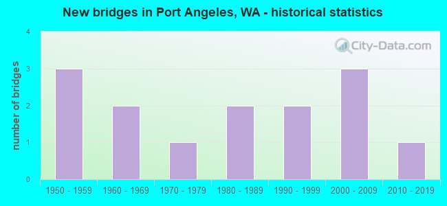
- New bridges - historical statistics
- 31950-1959
- 21960-1969
- 11970-1979
- 21980-1989
- 21990-1999
- 32000-2009
- 12010-2019
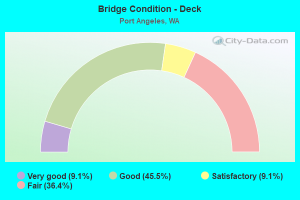
- Bridge Condition - Deck
- 9.1%Very good
- 45.5%Good
- 9.1%Satisfactory
- 36.4%Fair
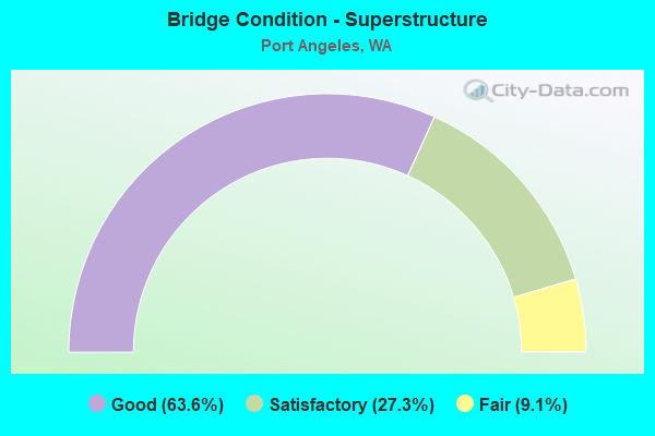
- Bridge Condition - Superstructure
- 63.6%Good
- 27.3%Satisfactory
- 9.1%Fair
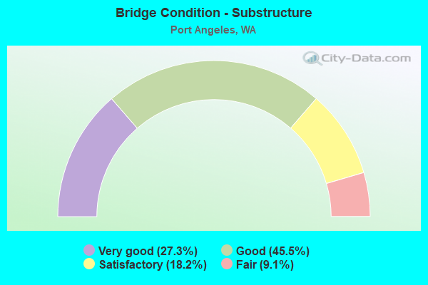
- Bridge Condition - Substructure
- 27.3%Very good
- 45.5%Good
- 18.2%Satisfactory
- 9.1%Fair
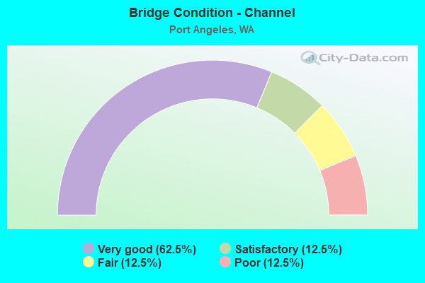
- Bridge Condition - Channel
- 62.5%Very good
- 12.5%Satisfactory
- 12.5%Fair
- 12.5%Poor
Find on map >> Show street view
Structure Number: 5115A, Location: JCT US 101 (Lat: 48.106583, Lng: -123.462611), Route carried "on" structure: State highway 117, Year Built: 1956, Status: Open, Structure Length: 3.90m (12.80ft), Average Daily Traffic: 1,212 (year 2019), Truck Traffic: 28%, Average Future Daily Traffic: 1,517 (year 2039), Features Intersected: US 101
Minimum Vertical Clearance: 30+ m (98+ ft), Kilometerpoint: 0.001, Lanes on structure: 1, Lanes under structure: 2, Owner: State Highway Agency, Approaching Roadway Width: 8.5m (27.9ft), Material/Design: Concrete continuous, Design/Construction: Girder and Floorbeam System, Number Of Spans In Main Unit: 3, Length of Maximum Span: 15.5m (50.9ft), Curb-To-Curb Width: 5.8m (19.0ft), Out-to-Out Width: 7.0m (23.0ft)
Condition: Deck: Satisfactory, Superstructure: Good, Substructure: Satisfactory, Operating Rating: 39.0 metric tons, Method Used To Determine Operating Rating: Load Factor (LF), Inventory Rating: 23.6 metric tons, Method Used To Determine Inventory Rating: Load Factor (LF), Structural Evaluation: Equal to present minimum criteria, Deck Geometry: High priority of replacement, Underclear: Somewhat better than minimum adequacy, Approach Roadway Alignment: Equal to present minimum criteria, Length Of Structure Improvement: 3.90m (12.80ft), Designated Inspection Frequency: Every 24 months, Inspection Date: March 2021, Bridge Improvement Cost: $768,000, Roadway Improvement Cost: $154,000, Total Project Cost: $1,536,000 ( Estimate for 2014), Deck Structure Type: Concrete Cast-file-Place, Wearing Surface/Protective System: Wearing Surface: Bituminous
Find on map >> Show street view
Structure Number: 9090A, Location: 37.0 E JCT SR 113 (Lat: 48.101278, Lng: -123.558528), Route carried "on" structure: State highway 112, Year Built: 1972, Status: Open, Structure Length: 17.19m (56.40ft), Average Daily Traffic: 5,654 (year 2019), Truck Traffic: 5%, Average Future Daily Traffic: 7,078 (year 2039), Design Load: HS 20+Mod, Features Intersected: ELWHA RIVER
Minimum Vertical Clearance: 30+ m (98+ ft), Kilometerpoint: 96.770, Lanes on structure: 2, Owner: State Highway Agency, Approaching Roadway Width: 11.0m (36.1ft), Material/Design: Concrete, Design/Construction: Arch - Deck, Number Of Spans In Main Unit: 1, Number Of Approach Spans: 3, Length of Maximum Span: 115.8m (379.9ft), Curb-To-Curb Width: 11.0m (36.1ft), Out-to-Out Width: 11.9m (39.0ft)
Condition: Deck: Good, Superstructure: Satisfactory, Substructure: Good, Channel: Very good, Operating Rating: 89.8 metric tons, Method Used To Determine Operating Rating: Load Factor (LF), Inventory Rating: 69.8 metric tons, Method Used To Determine Inventory Rating: Load Factor (LF), Structural Evaluation: Equal to present minimum criteria, Deck Geometry: Meets minimum limits, Waterway Adequacy: Equal to present desirable criteria, Approach Roadway Alignment: Equal to present desirable criteria, Length Of Structure Improvement: 17.19m (56.40ft), Designated Inspection Frequency: Every 48 months, Inspection Date: August 2018, Bridge Improvement Cost: $4,286,000, Roadway Improvement Cost: $857,000, Total Project Cost: $8,573,000 ( Estimate for 2014), Deck Structure Type: Concrete Cast-file-Place, Wearing Surface/Protective System: Wearing Surface: Latex Concrete
Find on map >> Show street view
Structure Number: 15259A, Location: 0.4 E JCT SR 117 (Lat: 48.107806, Lng: -123.453944), Route carried "on" structure: City street , Year Built: 1998, Status: Open, Structure Length: 4.21m (13.81ft), Average Daily Traffic: 1,941 (year 2002), Truck Traffic: 10%, Average Future Daily Traffic: 3,129 (year 2036), Design Load: HS 25 or greater, Features Intersected: US 101, Facility Carried by Structure: PINE ST/BLACK DIAM
Minimum Vertical Clearance: 30+ m (98+ ft), Kilometerpoint: 0.001, Lanes on structure: 2, Lanes under structure: 2, Owner: State Highway Agency, Approaching Roadway Width: 6.7m (22.0ft), Skew: 2 degrees, Material/Design: Concrete, Design/Construction: Stringer/Multi-beam, Number Of Spans In Main Unit: 1, Length of Maximum Span: 40.5m (132.9ft), Curb-To-Curb Width: 12.0m (39.4ft), Out-to-Out Width: 12.9m (42.3ft)
Condition: Deck: Good, Superstructure: Good, Substructure: Very good, Operating Rating: 89.8 metric tons, Method Used To Determine Operating Rating: Load Factor (LF), Inventory Rating: 46.3 metric tons, Method Used To Determine Inventory Rating: Load Factor (LF), Structural Evaluation: Better than present minimum criteria, Deck Geometry: Equal to present minimum criteria, Underclear: Meets minimum limits, Approach Roadway Alignment: Equal to present desirable criteria, Length Of Structure Improvement: 4.21m (13.81ft), Designated Inspection Frequency: Every 48 months, Inspection Date: August 2018, Bridge Improvement Cost: $662,000, Roadway Improvement Cost: $132,000, Total Project Cost: $1,325,000 ( Estimate for 2014), Deck Structure Type: Concrete Cast-file-Place, Wearing Surface/Protective System: Wearing Surface: Monolithic Concrete, Deck Protection: Epoxy Coated Reinforcing
Find on map >> Show street view
Structure Number: 81422, Location: 01.90 E JCT SR112 (Lat: 48.111639, Lng: -123.514444), Route carried "on" structure: County highway 93110, Year Built: 1957, Year Reconstructed: 1999, Status: Open, Structure Length: 1.22m (4.00ft), Average Daily Traffic: 1,748 (year 2017), Truck Traffic: 40%, Average Future Daily Traffic: 3,320 (year 2034), Design Load: HS 15, Features Intersected: DRY CREEK, Facility Carried by Structure: EDGEWOOD DRIVE
Minimum Vertical Clearance: 30+ m (98+ ft), Kilometerpoint: 0.001, Lanes on structure: 2, Owner: County Highway Agency, Approaching Roadway Width: 8.2m (26.9ft), Material/Design: Wood or Timber, Design/Construction: Stringer/Multi-beam, Number Of Spans In Main Unit: 2, Length of Maximum Span: 5.8m (19.0ft), Curb or Sidewalk Widths: Left: 0.2m (0.7ft), Right: 0.2m (0.7ft), Curb-To-Curb Width: 11.1m (36.4ft), Out-to-Out Width: 11.5m (37.7ft)
Condition: Deck: Good, Superstructure: Good, Substructure: Fair, Channel: Very good, Operating Rating: 36.3 metric tons, Method Used To Determine Operating Rating: Allowable Stress (AS), Inventory Rating: 26.3 metric tons, Method Used To Determine Inventory Rating: Allowable Stress (AS), Structural Evaluation: Somewhat better than minimum adequacy, Deck Geometry: Equal to present minimum criteria, Waterway Adequacy: Equal to present desirable criteria, Approach Roadway Alignment: Equal to present desirable criteria, Designated Inspection Frequency: Every 24 months, Inspection Date: December 2020, Deck Structure Type: Wood or Timber, Wearing Surface/Protective System: Wearing Surface: Bituminous
Find on map >> Show street view
Structure Number: 83749, Location: 00.2 SE JCT SR101 (Lat: 48.063333, Lng: -123.571667), Route carried "on" structure: County highway 30380, Year Built: 1986, Status: Open, Structure Length: 2.23m (7.32ft), Average Daily Traffic: 557 (year 2017), Truck Traffic: 40%, Average Future Daily Traffic: 1,170 (year 2037), Design Load: HS 20, Features Intersected: LITTLE RIVER, Facility Carried by Structure: OLY.HOTSPRINGS RD.
Minimum Vertical Clearance: 30+ m (98+ ft), Kilometerpoint: 0.001, Lanes on structure: 2, Owner: County Highway Agency, Approaching Roadway Width: 7.0m (23.0ft), Skew: 2 degrees, Material/Design: Prestressed concrete, Design/Construction: Tee Beam, Number Of Spans In Main Unit: 1, Length of Maximum Span: 21.3m (69.9ft), Curb or Sidewalk Widths: Left: 0.5m (1.6ft), Right: 0.5m (1.6ft), Curb-To-Curb Width: 8.8m (28.9ft), Out-to-Out Width: 9.8m (32.2ft)
Condition: Deck: Very good, Superstructure: Good, Substructure: Very good, Channel: Very good, Operating Rating: 89.8 metric tons, Method Used To Determine Operating Rating: Load and Resistance Factor (LRFR), Inventory Rating: 48.1 metric tons, Method Used To Determine Inventory Rating: Load and Resistance Factor (LRFR), Structural Evaluation: Better than present minimum criteria, Deck Geometry: Somewhat better than minimum adequacy, Waterway Adequacy: Equal to present desirable criteria, Approach Roadway Alignment: Equal to present minimum criteria, Designated Inspection Frequency: Every 24 months, Inspection Date: December 2020, Deck Structure Type: Concrete Precast Panels, Wearing Surface/Protective System: Wearing Surface: Bituminous, Membrane: Preformed Fabric
Find on map >> Show street view
Structure Number: 85033, Location: 0.7 W DOWNTOWN (Lat: 48.121667, Lng: -123.445000), Route carried "on" structure: City street 990, Year Built: 1980, Status: Open, Structure Length: 10.94m (35.89ft), Average Daily Traffic: 4,300 (year 2017), Truck Traffic: 3%, Average Future Daily Traffic: 6,470 (year 2038), Features Intersected: THIRD STREET, Facility Carried by Structure: TUMWATER STREET
Minimum Vertical Clearance: 30+ m (98+ ft), Kilometerpoint: 0.001, Lanes on structure: 2, Owner: City or Municipal Highway Agency, Approaching Roadway Width: 6.7m (22.0ft), Material/Design: Prestressed concrete, Design/Construction: Tee Beam, Number Of Spans In Main Unit: 5, Length of Maximum Span: 26.5m (86.9ft), Curb or Sidewalk Widths: Left: 0.0m, Right: 1.7m (5.6ft), Curb-To-Curb Width: 9.1m (29.9ft), Out-to-Out Width: 11.9m (39.0ft)
Condition: Deck: Good, Superstructure: Fair, Substructure: Good, Channel: Satisfactory, Operating Rating: 51.7 metric tons, Method Used To Determine Operating Rating: Load Factor (LF), Inventory Rating: 30.8 metric tons, Method Used To Determine Inventory Rating: Load Factor (LF), Structural Evaluation: Somewhat better than minimum adequacy, Deck Geometry: Meets minimum limits, Waterway Adequacy: Equal to present desirable criteria, Approach Roadway Alignment: Equal to present minimum criteria, Length Of Structure Improvement: 10.94m (35.89ft), Designated Inspection Frequency: Every 24 months, Inspection Date: Febuary 2021, Bridge Improvement Cost: $1,723,000, Roadway Improvement Cost: $345,000, Total Project Cost: $3,446,000 ( Estimate for 2014), Deck Structure Type: Other, Wearing Surface/Protective System: Wearing Surface: Bituminous, Membrane: Preformed Fabric
Find on map >> Show street view
Structure Number: 87964, Location: 0.4 W Lincoln St (US101) (Lat: 48.115389, Lng: -123.445111), Route carried "on" structure: City street 990, Year Built: 2008, Status: Open, Structure Length: 23.10m (75.79ft), Average Daily Traffic: 15,584 (year 2019), Truck Traffic: 5%, Average Future Daily Traffic: 22,220 (year 2041), Design Load: HL 93, Features Intersected: Valley St & Valley Crk, Facility Carried by Structure: 8th Street
Minimum Vertical Clearance: 30+ m (98+ ft), Kilometerpoint: 0.001, Lanes on structure: 2, Lanes under structure: 2, Owner: City or Municipal Highway Agency, Approaching Roadway Width: 12.2m (40.0ft), Material/Design: Prestressed concrete continuous, Design/Construction: Stringer/Multi-beam, Number Of Spans In Main Unit: 5, Length of Maximum Span: 47.2m (154.9ft), Curb or Sidewalk Widths: Left: 2.0m (6.6ft), Right: 2.0m (6.6ft), Curb-To-Curb Width: 10.4m (34.1ft), Out-to-Out Width: 14.9m (48.9ft)
Condition: Deck: Fair, Superstructure: Good, Substructure: Very good, Channel: Very good, Operating Rating: 55.3 metric tons, Method Used To Determine Operating Rating: Load and Resistance Factor (LRFR), Inventory Rating: 32.7 metric tons, Method Used To Determine Inventory Rating: Load and Resistance Factor (LRFR), Structural Evaluation: Better than present minimum criteria, Deck Geometry: Meets minimum limits, Underclear: Superior to present desirable criteria, Waterway Adequacy: Equal to present desirable criteria, Approach Roadway Alignment: Equal to present desirable criteria, Length Of Structure Improvement: 23.10m (75.79ft), Designated Inspection Frequency: Every 24 months, Inspection Date: September 2021, Bridge Improvement Cost: $6,367,000, Roadway Improvement Cost: $1,273,000, Total Project Cost: $12,734,000 ( Estimate for 2014), Deck Structure Type: Concrete Cast-file-Place, Wearing Surface/Protective System: Wearing Surface: Monolithic Concrete, Deck Protection: Epoxy Coated Reinforcing
Find on map >> Show street view
Structure Number: 87965, Location: 0.8 W Lincoln St (US1010 (Lat: 48.117778, Lng: -123.451111), Route carried "on" structure: City street 990, Year Built: 2008, Status: Open, Structure Length: 23.10m (75.79ft), Average Daily Traffic: 14,212 (year 2019), Truck Traffic: 5%, Average Future Daily Traffic: 21,066 (year 2041), Design Load: HL 93, Features Intersected: Tumwater Crk & SR117, Facility Carried by Structure: 8th Street
Minimum Vertical Clearance: 30+ m (98+ ft), Kilometerpoint: 5.295, Lanes on structure: 2, Lanes under structure: 2, Owner: City or Municipal Highway Agency, Approaching Roadway Width: 12.2m (40.0ft), Material/Design: Prestressed concrete continuous, Design/Construction: Stringer/Multi-beam, Number Of Spans In Main Unit: 5, Length of Maximum Span: 47.2m (154.9ft), Curb or Sidewalk Widths: Left: 2.0m (6.6ft), Right: 2.0m (6.6ft), Curb-To-Curb Width: 10.4m (34.1ft), Out-to-Out Width: 14.9m (48.9ft)
Condition: Deck: Fair, Superstructure: Good, Substructure: Good, Channel: Very good, Operating Rating: 55.3 metric tons, Method Used To Determine Operating Rating: Load and Resistance Factor (LRFR), Inventory Rating: 32.7 metric tons, Method Used To Determine Inventory Rating: Load and Resistance Factor (LRFR), Structural Evaluation: Better than present minimum criteria, Deck Geometry: Meets minimum limits, Underclear: Equal to present minimum criteria, Waterway Adequacy: Equal to present desirable criteria, Approach Roadway Alignment: Equal to present desirable criteria, Length Of Structure Improvement: 23.10m (75.79ft), Designated Inspection Frequency: Every 24 months, Inspection Date: September 2021, Bridge Improvement Cost: $6,367,000, Roadway Improvement Cost: $1,273,000, Total Project Cost: $12,734,000 ( Estimate for 2014), Deck Structure Type: Concrete Cast-file-Place, Wearing Surface/Protective System: Wearing Surface: Monolithic Concrete, Deck Protection: Epoxy Coated Reinforcing
Find on map >> Show street view
Structure Number: 8843, Location: 0.4 mi N of W Hill St. (Lat: 48.134328, Lng: -123.465408), Route carried "on" structure: City street 990, Year Built: 1961, Status: Open, Structure Length: 0.91m (2.99ft), Average Daily Traffic: 3,608 (year 2017), Truck Traffic: 8%, Average Future Daily Traffic: 4,020 (year 2038), Design Load: H 20, Features Intersected: Log Channel, Facility Carried by Structure: Marine Drive
Minimum Vertical Clearance: 30+ m (98+ ft), Kilometerpoint: 0.001, Lanes on structure: 2, Owner: City or Municipal Highway Agency, Approaching Roadway Width: 8.2m (26.9ft), Skew: 5 degrees, Material/Design: Concrete, Design/Construction: Channel Beam, Number Of Spans In Main Unit: 1, Length of Maximum Span: 8.8m (28.9ft), Curb or Sidewalk Widths: Left: 0.9m (3.0ft), Right: 0.0m, Curb-To-Curb Width: 8.3m (27.2ft), Out-to-Out Width: 9.8m (32.2ft)
Condition: Deck: Fair, Superstructure: Satisfactory, Substructure: Satisfactory, Channel: Poor, Operating Rating: 82.5 metric tons, Method Used To Determine Operating Rating: Load Factor (LF), Inventory Rating: 49.0 metric tons, Method Used To Determine Inventory Rating: Load Factor (LF), Structural Evaluation: Equal to present minimum criteria, Deck Geometry: High priority of corrective action, Waterway Adequacy: Better than present minimum criteria, Approach Roadway Alignment: Equal to present desirable criteria, Length Of Structure Improvement: 0.91m (2.99ft), Designated Inspection Frequency: Every 24 months, Underwater Inspection Frequency: Every 72 months, Inspection Date: Febuary 2021, Underwater Inspection Date: Febuary 2019, Bridge Improvement Cost: $174,000, Roadway Improvement Cost: $35,000, Total Project Cost: $348,000 ( Estimate for 2014), Deck Structure Type: Other, Wearing Surface/Protective System: Wearing Surface: Bituminous, Membrane: Preformed Fabric
Find on map >> Show street view
Structure Number: 88631, Location: 0.8 E JCT SR 101 (Lat: 48.104806, Lng: -123.421389), Route carried "on" structure: City street 990, Year Built: 2013, Status: Open, Structure Length: 4.45m (14.60ft), Average Daily Traffic: 7,306 (year 2019), Truck Traffic: 5%, Average Future Daily Traffic: 8,401 (year 2041), Design Load: HL 93, Features Intersected: PEABODY CREEK, Facility Carried by Structure: LAURIDSEN BLVD
Minimum Vertical Clearance: 30+ m (98+ ft), Kilometerpoint: 0.001, Lanes on structure: 3, Owner: City or Municipal Highway Agency, Approaching Roadway Width: 14.0m (45.9ft), Material/Design: Prestressed concrete, Design/Construction: Stringer/Multi-beam, Number Of Spans In Main Unit: 1, Length of Maximum Span: 43.6m (143.0ft), Curb or Sidewalk Widths: Left: 2.0m (6.6ft), Right: 2.0m (6.6ft), Curb-To-Curb Width: 14.2m (46.6ft), Out-to-Out Width: 18.7m (61.4ft)
Condition: Deck: Fair, Superstructure: Good, Substructure: Good, Channel: Fair, Operating Rating: 55.7 metric tons, Method Used To Determine Operating Rating: Load and Resistance Factor Rating (LRFR) rating reported by rating factor(RF) method using HL-93 loadings, Inventory Rating: 41.5 metric tons, Method Used To Determine Inventory Rating: Load and Resistance Factor Rating (LRFR) rating reported by rating factor(RF) method using HL-93 loadings, Structural Evaluation: Better than present minimum criteria, Deck Geometry: Somewhat better than minimum adequacy, Waterway Adequacy: Equal to present desirable criteria, Approach Roadway Alignment: Equal to present desirable criteria, Length Of Structure Improvement: 4.45m (14.60ft), Designated Inspection Frequency: Every 24 months, Inspection Date: September 2021, Bridge Improvement Cost: $1,402,000, Roadway Improvement Cost: $280,000, Total Project Cost: $2,803,000 ( Estimate for 2014), Deck Structure Type: Concrete Cast-file-Place, Wearing Surface/Protective System: Wearing Surface: Monolithic Concrete, Deck Protection: Epoxy Coated Reinforcing
Find on map >> Show street view
Structure Number: 9500024P, Location: 4.1 MI. S. OF JCT. HWY. 1 (Lat: 48.064639, Lng: -123.427306), Route carried "on" structure: ServiceState lands road , Year Built: 1969, Status: Open, Structure Length: 4.54m (14.90ft), Average Daily Traffic: 5 (year 2011), Average Future Daily Traffic: 10 (year 2031), Features Intersected: HURRICANE RIDGE ROAD, Facility Carried by Structure: DNR ACCESS ROAD
Minimum Vertical Clearance: 30+ m (98+ ft), Kilometerpoint: 0.241, Lanes on structure: 1, Lanes under structure: 2, Owner: State Agenciy, Approaching Roadway Width: 3.7m (12.1ft), Material/Design: Concrete continuous, Design/Construction: Box Beam or Girders - Single/Spread, Number Of Spans In Main Unit: 3, Length of Maximum Span: 22.3m (73.2ft), Curb-To-Curb Width: 4.4m (14.4ft), Out-to-Out Width: 5.2m (17.1ft)
Condition: Deck: Good, Superstructure: Satisfactory, Substructure: Good, Operating Rating: 85.3 metric tons, Method Used To Determine Operating Rating: Load Factor (LF), Inventory Rating: 50.8 metric tons, Method Used To Determine Inventory Rating: Load Factor (LF), Structural Evaluation: Equal to present minimum criteria, Deck Geometry: Equal to present minimum criteria, Underclear: High priority of corrective action, Approach Roadway Alignment: Equal to present minimum criteria, Designated Inspection Frequency: Every 24 months, Inspection Date: August 2021, Bridge Improvement Cost: $50,000, Roadway Improvement Cost: $5,000, Total Project Cost: $75,000, Deck Structure Type: Concrete Cast-file-Place
Find on map >> Show street view
Structure Number: 5115A, Location: 3.6 N JCT SR 112 (Lat: 48.106583, Lng: -123.462611), Route carried "under" structure: US 101, Year Built: 1956, Structure Length: 0. m, Average Daily Traffic: 10,916 (year 2019), Truck Traffic: 4%, Features Intersected: US 101, Facility Carried by Structure: SR 117 NB
Minimum Vertical Clearance: 9.30m (30.51ft), Kilometerpoint: 396.301, Lanes on structure: 1, Lanes under structure: 2, Material/Design: Concrete continuous, Design/Construction: Girder and Floorbeam System, Length of Maximum Span: 15.5m (50.9ft)
Find on map >> Show street view
Structure Number: 15259A, Location: 0.4 E JCT SR 117 (Lat: 48.107806, Lng: -123.453944), Route carried "under" structure: US 101, Year Built: 1998, Structure Length: 0. m, Average Daily Traffic: 11,322 (year 2019), Truck Traffic: 4%, Features Intersected: US 101, Facility Carried by Structure: PINE ST/BLACK DIAM
Minimum Vertical Clearance: 6.43m (21.10ft), Kilometerpoint: 396.929, Lanes on structure: 2, Lanes under structure: 2, Material/Design: Concrete, Design/Construction: Stringer/Multi-beam, Length of Maximum Span: 40.5m (132.9ft)
Find on map >> Show street view
Structure Number: 87965, Location: 1.0 N JCT US 101 (Lat: 48.117778, Lng: -123.451111), Route carried "under" structure: State highway 117, Year Built: 2008, Structure Length: 0. m, Average Daily Traffic: 4,786 (year 2014), Truck Traffic: 32%, Features Intersected: Tumwater Crk & SR117, Facility Carried by Structure: 8th Street
Minimum Vertical Clearance: 24.31m (79.76ft), Kilometerpoint: 1.561, Lanes on structure: 2, Lanes under structure: 2, Material/Design: Prestressed concrete continuous, Design/Construction: Stringer/Multi-beam, Length of Maximum Span: 47.2m (154.9ft)