Bridge Statistics for Port Chester, New York (NY)
Condition, Traffic, Stress, Structural Evaluation, Project Costs
- National Bridge Inventory (NBI) Statistics
- 19Number of bridges
- 203ft / 61.9mTotal length
- $94,720,000Total costs
- 396,861Total average daily traffic
- 9,424Total average daily truck traffic
- National Bridge Inventory (NBI) Registered Bridges for Port Chester
- No street view available for this location
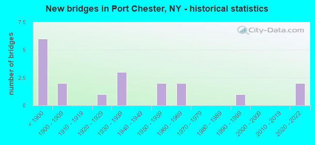
- New bridges - historical statistics
- 6Before 1900
- 21900-1909
- 11920-1929
- 31930-1939
- 21950-1959
- 21960-1969
- 11990-1999
- 22020-2022
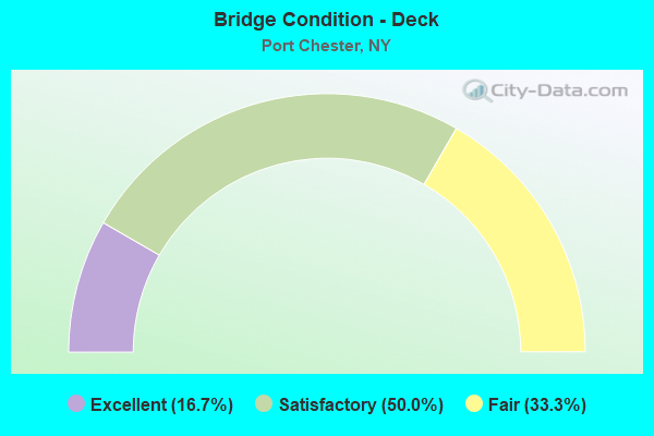
- Bridge Condition - Deck
- 16.7%Excellent
- 50.0%Satisfactory
- 33.3%Fair
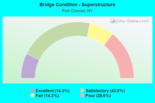
- Bridge Condition - Superstructure
- 14.3%Excellent
- 42.9%Satisfactory
- 14.3%Fair
- 28.6%Poor
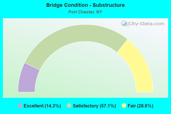
- Bridge Condition - Substructure
- 14.3%Excellent
- 57.1%Satisfactory
- 28.6%Fair
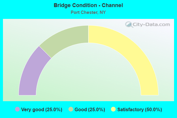
- Bridge Condition - Channel
- 25.0%Very good
- 25.0%Good
- 50.0%Satisfactory
Find on map >> Show street view
Structure Number: 1000121, Location: JCT RTE 1+N Y+CONN ST LN (Lat: 41.012628, Lng: -73.655794), Route carried "on" structure: US 1, Year Built: 1926, Status: Open, Structure Length: 2.44m (8.01ft), Average Daily Traffic: 12,811 (year 2009), Truck Traffic: 4%, Average Future Daily Traffic: 12,871 (year 2040), Design Load: H 20, Features Intersected: BYRAM RIVER
Minimum Vertical Clearance: 30+ m (98+ ft), Kilometerpoint: 20.209, Lanes on structure: 2, Base Highway Network: Yes, Owner: State Highway Agency, Approaching Roadway Width: 13.1m (43.0ft), Material/Design: Concrete, Design/Construction: Tee Beam, Number Of Spans In Main Unit: 2, Length of Maximum Span: 10.9m (35.8ft), Curb or Sidewalk Widths: Left: 2.5m (8.2ft), Right: 2.5m (8.2ft), Curb-To-Curb Width: 13.7m (44.9ft), Out-to-Out Width: 19.8m (65.0ft)
Condition: Deck: Satisfactory, Superstructure: Poor, Substructure: Satisfactory, Channel: Satisfactory, Operating Rating: 47.2 metric tons, Method Used To Determine Operating Rating: Load Factor (LF), Inventory Rating: 28.1 metric tons, Method Used To Determine Inventory Rating: Load Factor (LF), Structural Evaluation: Meets minimum limits, Deck Geometry: Superior to present desirable criteria, Waterway Adequacy: Equal to present desirable criteria, Approach Roadway Alignment: Meets minimum limits, Length Of Structure Improvement: 2.43m (7.97ft), Designated Inspection Frequency: Every 24 months, Inspection Date: April 2020, Bridge Improvement Cost: $1,661,000, Roadway Improvement Cost: $972,000, Total Project Cost: $2,633,000 ( Estimate for 2021), Deck Structure Type: Concrete Cast-file-Place, Wearing Surface/Protective System: Wearing Surface: Bituminous, Membrane: Other
Find on map >> Show street view
Structure Number: 1000122, Location: JCT RTE 1+N Y+CONN ST LN (Lat: 41.012136, Lng: -73.655383), Route carried "on" structure: US 1, Year Built: 1888, Status: Open, Structure Length: 2.74m (8.99ft), Average Daily Traffic: 12,811 (year 2009), Truck Traffic: 4%, Average Future Daily Traffic: 12,871 (year 2040), Design Load: HS 20, Features Intersected: BYRAM RIVER
Minimum Vertical Clearance: 30+ m (98+ ft), Kilometerpoint: 20.209, Lanes on structure: 2, Base Highway Network: Yes, Owner: State Highway Agency, Approaching Roadway Width: 9.1m (29.9ft), Material/Design: Masonry, Design/Construction: Arch - Deck, Number Of Spans In Main Unit: 2, Length of Maximum Span: 10.0m (32.8ft), Curb or Sidewalk Widths: Left: 1.8m (5.9ft), Right: 2.0m (6.6ft), Curb-To-Curb Width: 9.2m (30.2ft), Out-to-Out Width: 14.6m (47.9ft)
Condition: Superstructure: Fair, Substructure: Satisfactory, Channel: Good, Operating Rating: 76.8 metric tons, Method Used To Determine Operating Rating: Field evaluation and documented engineering judgment, Inventory Rating: 19.6 metric tons, Method Used To Determine Inventory Rating: Field evaluation and documented engineering judgment, Structural Evaluation: Meets minimum limits, Deck Geometry: Meets minimum limits, Waterway Adequacy: Somewhat better than minimum adequacy, Approach Roadway Alignment: Meets minimum limits, Length Of Structure Improvement: 2.74m (8.99ft), Designated Inspection Frequency: Every 24 months, Inspection Date: May 2020, Bridge Improvement Cost: $3,169,000, Roadway Improvement Cost: $1,856,000, Total Project Cost: $5,024,000 ( Estimate for 2021), Wearing Surface/Protective System: Wearing Surface: Bituminous
Find on map >> Show street view
Structure Number: 104488, Location: 2.3 MI E JCT RTE I287+HRP (Lat: 40.994392, Lng: -73.678706), Route carried "on" structure: Other road , Year Built: 1960, Status: Open, Structure Length: 5.67m (18.60ft), Average Daily Traffic: 4,444 (year 2016), Truck Traffic: 2%, Average Future Daily Traffic: 6,222 (year 2036), Design Load: HS 20+Mod, Features Intersected: 287IX, RTE I287, Facility Carried by Structure: HIGH STREET
Minimum Vertical Clearance: 30+ m (98+ ft), Kilometerpoint: 0.225, Lanes on structure: 2, Lanes under structure: 7, Owner: State Highway Agency, Approaching Roadway Width: 9.1m (29.9ft), Skew: 4 degrees, Material/Design: Steel, Design/Construction: Stringer/Multi-beam, Number Of Spans In Main Unit: 2, Length of Maximum Span: 28.6m (93.8ft), Curb or Sidewalk Widths: Left: 1.6m (5.2ft), Right: 1.6m (5.2ft), Curb-To-Curb Width: 9.1m (29.9ft), Out-to-Out Width: 12.8m (42.0ft)
Condition: Deck: Satisfactory, Superstructure: Satisfactory, Substructure: Fair, Operating Rating: 51.7 metric tons, Method Used To Determine Operating Rating: Load Factor (LF), Inventory Rating: 30.8 metric tons, Method Used To Determine Inventory Rating: Load Factor (LF), Structural Evaluation: Somewhat better than minimum adequacy, Deck Geometry: Meets minimum limits, Underclear: High priority of corrective action, Approach Roadway Alignment: Equal to present desirable criteria, Length Of Structure Improvement: 5.66m (18.57ft), Designated Inspection Frequency: Every 24 months, Inspection Date: October 2020, Bridge Improvement Cost: $4,418,000, Roadway Improvement Cost: $2,587,000, Total Project Cost: $7,005,000 ( Estimate for 2021), Deck Structure Type: Concrete Cast-file-Place, Wearing Surface/Protective System: Wearing Surface: Monolithic Concrete
Find on map >> Show street view
Structure Number: 226527, Location: IN PORT CHESTER (Lat: 40.998803, Lng: -73.666267), Route carried "on" structure: Other road , Year Built: 1887, Status: Posted for load, Structure Length: 1.80m (5.91ft), Average Daily Traffic: 449 (year 2017), Truck Traffic: 2%, Average Future Daily Traffic: 629 (year 2037), Features Intersected: MNRR NH LINE, Facility Carried by Structure: WILLIAM STREET
Minimum Vertical Clearance: 30+ m (98+ ft), Kilometerpoint: 0.097, Lanes on structure: 2, Owner: Railroad, Maintenance Responsibility: Town or Township Highway Agency, Approaching Roadway Width: 7.0m (23.0ft), Material/Design: Steel, Design/Construction: Girder and Floorbeam System, Number Of Spans In Main Unit: 1, Length of Maximum Span: 17.0m (55.8ft), Curb or Sidewalk Widths: Left: 2.3m (7.5ft), Right: 2.3m (7.5ft), Curb-To-Curb Width: 7.0m (23.0ft), Out-to-Out Width: 12.3m (40.4ft)
Condition: Deck: Fair, Superstructure: Poor, Substructure: Fair, Operating Rating: 16.3 metric tons, Method Used To Determine Operating Rating: Allowable Stress (AS), Inventory Rating: 10.9 metric tons, Method Used To Determine Inventory Rating: Allowable Stress (AS), Structural Evaluation: Meets minimum limits, Deck Geometry: High priority of replacement, Underclear: High priority of corrective action, Approach Roadway Alignment: Equal to present minimum criteria, Bridge Posting: Required (Relationship of Operating Rating to Maximum Legal Load: > 39.9% below), Length Of Structure Improvement: 1.79m (5.87ft), Designated Inspection Frequency: Every 12 months, Critical Feature Inspection Frequency: Every 12 months, Inspection Date: December 2021, Critical Feature Inspection Date: December 2021, Bridge Improvement Cost: $1,833,000, Roadway Improvement Cost: $1,074,000, Total Project Cost: $2,907,000 ( Estimate for 2021), Deck Structure Type: Wood or Timber, Wearing Surface/Protective System: Wearing Surface: Bituminous
Find on map >> Show street view
Structure Number: 334861, Location: PORT CHESTER-GREENWICH CT (Lat: 41.004033, Lng: -73.658808), Route carried "on" structure: County highway , Year Built: 1993, Status: Open, Structure Length: 4.27m (14.01ft), Truck Traffic: 3%, Design Load: HS 20+Mod, Features Intersected: BYRAM RIVER, Facility Carried by Structure: MILL STREET
Minimum Vertical Clearance: 30+ m (98+ ft), Kilometerpoint: 0.097, Lanes on structure: 2, Owner: County Highway Agency, Approaching Roadway Width: 8.5m (27.9ft), Navigation Control: Yes ( Vertical Clearance: 0.6m (2.0ft), Horizontal Clearance: 12.4m (40.7ft)), Material/Design: Prestressed concrete, Design/Construction: Box Beam or Girders - Multiple, Number Of Spans In Main Unit: 3, Length of Maximum Span: 14.0m (45.9ft), Curb or Sidewalk Widths: Left: 1.5m (4.9ft), Right: 1.5m (4.9ft), Curb-To-Curb Width: 8.8m (28.9ft), Out-to-Out Width: 12.6m (41.3ft)
Condition: Deck: Satisfactory, Superstructure: Satisfactory, Substructure: Satisfactory, Channel: Satisfactory, Operating Rating: 51.2 metric tons, Method Used To Determine Operating Rating: Load and Resistance Factor Rating (LRFR) rating reported by rating factor(RF) method using HL-93 loadings, Inventory Rating: 39.5 metric tons, Method Used To Determine Inventory Rating: Load and Resistance Factor Rating (LRFR) rating reported by rating factor(RF) method using HL-93 loadings, Structural Evaluation: Equal to present minimum criteria, Deck Geometry: Better than present minimum criteria, Waterway Adequacy: Somewhat better than minimum adequacy, Approach Roadway Alignment: Equal to present desirable criteria, Length Of Structure Improvement: 4.26m (13.98ft), Designated Inspection Frequency: Every 24 months, Inspection Date: April 2021, Bridge Improvement Cost: $1,534,000, Roadway Improvement Cost: $898,000, Total Project Cost: $2,433,000 ( Estimate for 2021), Wearing Surface/Protective System: Wearing Surface: Integral Concrete
Find on map >> Show street view
Structure Number: 551481, Location: .2 MI E JCT I95 & I287 (Lat: 40.988378, Lng: -73.666203), Route carried "on" structure: Other road , Year Built: 2020, Status: Open, Structure Length: 6.51m (21.36ft), Average Daily Traffic: 4,781 (year 2017), Truck Traffic: 3%, Average Future Daily Traffic: 5,807 (year 2040), Design Load: HS 20+Mod, Features Intersected: 95IX, RTE I95, Facility Carried by Structure: GRACE CHURCH ST
Minimum Vertical Clearance: 30+ m (98+ ft), Kilometerpoint: 1.078, Lanes on structure: 2, Lanes under structure: 10, Owner: State Toll Authority, Approaching Roadway Width: 9.1m (29.9ft), Skew: 2 degrees, Material/Design: Steel continuous, Design/Construction: Stringer/Multi-beam, Number Of Spans In Main Unit: 2, Length of Maximum Span: 33.5m (109.9ft), Curb or Sidewalk Widths: Left: 1.5m (4.9ft), Right: 1.5m (4.9ft), Curb-To-Curb Width: 9.1m (29.9ft), Out-to-Out Width: 13.0m (42.7ft)
Condition: Deck: Excellent, Superstructure: Excellent, Substructure: Excellent, Inventory Rating: 71.7 metric tons, Method Used To Determine Inventory Rating: Load Factor (LF), Structural Evaluation: Superior to present desirable criteria, Deck Geometry: Meets minimum limits, Underclear: Somewhat better than minimum adequacy, Approach Roadway Alignment: Equal to present desirable criteria, Length Of Structure Improvement: 6.51m (21.36ft), Designated Inspection Frequency: Every 24 months, Inspection Date: November 2020, Bridge Improvement Cost: $4,548,000, Roadway Improvement Cost: $2,663,000, Total Project Cost: $7,212,000 ( Estimate for 2021), Deck Structure Type: Concrete Cast-file-Place, Wearing Surface/Protective System: Wearing Surface: Integral Concrete
Find on map >> Show street view
Structure Number: 5514829, Location: 0.7 MI NE JCT RTE 1 &I-95 (Lat: 40.992892, Lng: -73.661047), Route carried "on" structure: Interstate 95, Year Built: 1956, Year Reconstructed: 1980, Status: Open, Structure Length: 38.50m (126.31ft), Average Daily Traffic: 58,294 (year 2018), Truck Traffic: 14%, Average Future Daily Traffic: 98,715 (year 2040), Design Load: HS 20+Mod, Features Intersected: FOX ISLAND ROAD, BYRAM R
Minimum Vertical Clearance: 30+ m (98+ ft), Kilometerpoint: 18.117, Lanes on structure: 6, Lanes under structure: 4, Base Highway Network: Yes, Toll: On toll road, Owner: State Toll Authority, Approaching Roadway Width: 29.6m (97.1ft), Skew: 22 degrees, Navigation Control: Yes ( Vertical Clearance: 18.3m (60.0ft), Horizontal Clearance: 48.8m (160.1ft)), Material/Design: Steel continuous, Design/Construction: Girder and Floorbeam System, Number Of Spans In Main Unit: 3, Number Of Approach Spans: 13, Length of Maximum Span: 64.6m (211.9ft), Curb-To-Curb Width: 29.6m (97.1ft), Out-to-Out Width: 31.4m (103.0ft)
Condition: Deck: Fair, Superstructure: Satisfactory, Substructure: Satisfactory, Channel: Very good, Operating Rating: 53.5 metric tons, Method Used To Determine Operating Rating: Load Factor (LF), Inventory Rating: 32.7 metric tons, Method Used To Determine Inventory Rating: Load Factor (LF), Structural Evaluation: Equal to present minimum criteria, Deck Geometry: Superior to present desirable criteria, Underclear: High priority of corrective action, Waterway Adequacy: Equal to present desirable criteria, Approach Roadway Alignment: Equal to present desirable criteria, Length Of Structure Improvement: 38.49m (126.28ft), Designated Inspection Frequency: Every 24 months, Critical Feature Inspection Frequency: Every 24 months, Underwater Inspection Frequency: Every 60 months, Inspection Date: August 2021, Critical Feature Inspection Date: August 2021, Underwater Inspection Date: June 2021, Bridge Improvement Cost: $42,575,000, Roadway Improvement Cost: $24,932,000, Total Project Cost: $67,506,000 ( Estimate for 2021), Deck Structure Type: Concrete Cast-file-Place, Wearing Surface/Protective System: Wearing Surface: Bituminous, Membrane: Other
Find on map >> Show street view
Structure Number: 104488, Location: 2.3 MI E JCT RTE I287+HRP (Lat: 40.994392, Lng: -73.678706), Route carried "under" structure: Interstate 287, Year Built: 1960, Structure Length: 0. m, Average Daily Traffic: 122,164 (year 2002), Features Intersected: 287IX, RTE I287, Facility Carried by Structure: HIGH STREET
Minimum Vertical Clearance: 6.12m (20.08ft), Kilometerpoint: 16.267, Lanes on structure: 2, Lanes under structure: 4, Material/Design: Steel, Design/Construction: Stringer/Multi-beam, Length of Maximum Span: 28.6m (93.8ft)
Find on map >> Show street view
Structure Number: 551481, Location: .2 MI E JCT I95 & I287 (Lat: 40.988378, Lng: -73.666203), Route carried "under" structure: Interstate 95, Year Built: 2020, Structure Length: 0. m, Average Daily Traffic: 121,210 (year 1998), Features Intersected: 95IX, RTE I95, Facility Carried by Structure: GRACE CHURCH ST
Minimum Vertical Clearance: 6.58m (21.59ft), Kilometerpoint: 23.266, Lanes on structure: 2, Lanes under structure: 6, Toll: On Interstate toll segment, Material/Design: Steel continuous, Design/Construction: Stringer/Multi-beam, Length of Maximum Span: 33.5m (109.9ft)
Find on map >> Show street view
Structure Number: 5514829, Location: 0.7 MI NE JCT RTE 1 &I-95 (Lat: 40.992892, Lng: -73.661047), Route carried "under" structure: City street , Year Built: 1956, Structure Length: 0. m, Features Intersected: FOX ISLAND ROAD, BYRAM R, Facility Carried by Structure: RTE I95
Minimum Vertical Clearance: 7.62m (25.00ft), Kilometerpoint: 0.000, Lanes on structure: 6, Lanes under structure: 2, Material/Design: Steel continuous, Design/Construction: Girder and Floorbeam System, Length of Maximum Span: 64.6m (211.9ft)
Find on map >> Show street view
Structure Number: 700011, Location: JCT RR&RTE 1 PORT CHESTER (Lat: 41.004944, Lng: -73.659731), Route carried "under" structure: US 1, Year Built: 1937, Structure Length: 0. m, Average Daily Traffic: 16,700 (year 1972), Features Intersected: RTE 1, Facility Carried by Structure: MNRR NH LINE
Minimum Vertical Clearance: 4.01m (13.16ft), Kilometerpoint: 2.188, Lanes under structure: 3, Material/Design: Steel, Design/Construction: Box Beam or Girders - Multiple, Length of Maximum Span: 20.7m (67.9ft)
Find on map >> Show street view
Structure Number: 771252, Location: AT PORT CHESTER (Lat: 40.997356, Lng: -73.667467), Route carried "under" structure: US 1, Year Built: 1888, Structure Length: 0. m, Average Daily Traffic: 23,997 (year 1999), Features Intersected: RTE 1, Facility Carried by Structure: MNRR NH LINE
Minimum Vertical Clearance: 3.93m (12.89ft), Kilometerpoint: 1.030, Lanes under structure: 4, Material/Design: Steel, Design/Construction: Stringer/Multi-beam, Length of Maximum Span: 25.6m (84.0ft)
Find on map >> Show street view
Structure Number: 771259, Location: AT PORT CHESTER (Lat: 41.002461, Lng: -73.663219), Route carried "under" structure: Other road , Year Built: 1907, Structure Length: 0. m, Average Daily Traffic: 100 (year 2021), Features Intersected: RTE 120A, KING STREET, Facility Carried by Structure: MNRR NH LINE
Minimum Vertical Clearance: 3.40m (11.15ft), Kilometerpoint: 0.000, Material/Design: Steel, Design/Construction: Girder and Floorbeam System, Length of Maximum Span: 20.7m (67.9ft)
Find on map >> Show street view
Structure Number: 771259, Location: AT PORT CHESTER (Lat: 41.002461, Lng: -73.663219), Route carried "under" structure: State highway 120A, Year Built: 1907, Structure Length: 0. m, Average Daily Traffic: 10,000 (year 2021), Features Intersected: RTE 120A, KING STREET, Facility Carried by Structure: MNRR NH LINE
Minimum Vertical Clearance: 3.40m (11.15ft), Kilometerpoint: 0.000, Lanes under structure: 4, Material/Design: Steel, Design/Construction: Girder and Floorbeam System, Length of Maximum Span: 20.7m (67.9ft)
Find on map >> Show street view
Structure Number: 77126, Location: AT PORT CHESTER (Lat: 41.000669, Lng: -73.664717), Route carried "under" structure: State highway 120A, Year Built: 1931, Structure Length: 0. m, Average Daily Traffic: 9,000 (year 2021), Features Intersected: RTE 120A, WESTCHESTER AV, Facility Carried by Structure: MNRR NH LINE
Minimum Vertical Clearance: 3.65m (11.98ft), Kilometerpoint: 0.000, Lanes under structure: 2, Material/Design: Steel, Design/Construction: Girder and Floorbeam System, Length of Maximum Span: 22.8m (74.8ft)
Find on map >> Show street view
Structure Number: 77126, Location: AT PORT CHESTER (Lat: 41.000669, Lng: -73.664717), Route carried "under" structure: Other road , Year Built: 1931, Structure Length: 0. m, Average Daily Traffic: 100 (year 2021), Features Intersected: RTE 120A, WESTCHESTER AV, Facility Carried by Structure: MNRR NH LINE
Minimum Vertical Clearance: 3.65m (11.98ft), Kilometerpoint: 0.000, Lanes under structure: 2, Material/Design: Steel, Design/Construction: Girder and Floorbeam System, Length of Maximum Span: 22.8m (74.8ft)
Find on map >> Show street view
Structure Number: 771261, Location: AT PORT CHESTER (Lat: 41.003075, Lng: -73.662706), Route carried "under" structure: Other road , Year Built: 1891, Structure Length: 0. m, Features Intersected: WILLET STREET, Facility Carried by Structure: MNRR NH LINE
Minimum Vertical Clearance: 3.73m (12.24ft), Kilometerpoint: 0.000, Lanes under structure: 2, Material/Design: Steel, Design/Construction: Stringer/Multi-beam, Length of Maximum Span: 18.8m (61.7ft)
Find on map >> Show street view
Structure Number: 771262, Location: AT PORT CHESTER (Lat: 41.004303, Lng: -73.661561), Route carried "under" structure: Other road , Year Built: 1892, Structure Length: 0. m, Features Intersected: HIGHLAND STREET, Facility Carried by Structure: MNRR NH LINE
Minimum Vertical Clearance: 3.37m (11.06ft), Kilometerpoint: 0.000, Lanes under structure: 2, Material/Design: Steel, Design/Construction: Stringer/Multi-beam, Length of Maximum Span: 14.3m (46.9ft)
Find on map >> Show street view
Structure Number: 771263, Location: AT PORT CHESTER (Lat: 41.004153, Lng: -73.661433), Route carried "under" structure: Other road , Year Built: 1892, Structure Length: 0. m, Features Intersected: HIGHLAND STREET, Facility Carried by Structure: MNRR NH LINE
Minimum Vertical Clearance: 3.35m (10.99ft), Kilometerpoint: 0.225, Lanes under structure: 2, Material/Design: Steel, Design/Construction: Stringer/Multi-beam, Length of Maximum Span: 14.6m (47.9ft)