Bridge Statistics for Port Clinton, Ohio (OH)
Condition, Traffic, Stress, Structural Evaluation, Project Costs
- National Bridge Inventory (NBI) Statistics
- 28Number of bridges
- 423ft / 129mTotal length
- 183,341Total average daily traffic
- 22,704Total average daily truck traffic
- National Bridge Inventory (NBI) Registered Bridges for Port Clinton
- No street view available for this location
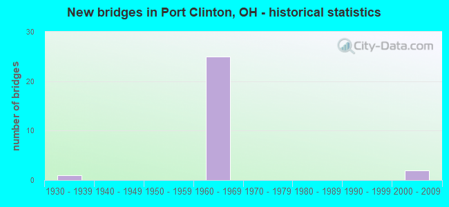
- New bridges - historical statistics
- 11930-1939
- 251960-1969
- 22000-2009

- Reconstructed bridges - Historical Statistics
- 21990-1999
- 12000-2009
- 32010-2019


- Bridge Condition - Deck
- 23.5%Very good
- 70.6%Good
- 5.9%Satisfactory

- Bridge Condition - Superstructure
- 23.5%Very good
- 64.7%Good
- 11.8%Satisfactory

- Bridge Condition - Substructure
- 17.6%Very good
- 64.7%Good
- 17.6%Satisfactory

- Bridge Condition - Channel
- 28.6%Very good
- 71.4%Good
Find on map >> Show street view
Structure Number: 6200214, Location: 1/8 MI E. SR 358 (Lat: 41.529169, Lng: -83.017339), Route carried "on" structure: State highway 2, Year Built: 1967, Status: Open, Structure Length: 2.04m (6.69ft), Average Daily Traffic: 7,963 (year 2018), Truck Traffic: 13%, Average Future Daily Traffic: 9,773 (year 2038), Design Load: H 20, Features Intersected: LACARPE CREEK
Minimum Vertical Clearance: 30+ m (98+ ft), Kilometerpoint: 26.619, Lanes on structure: 5, Base Highway Network: Yes, Owner: State Highway Agency, Approaching Roadway Width: 19.5m (64.0ft), Skew: 1 degrees, Material/Design: Concrete continuous, Design/Construction: Slab, Number Of Spans In Main Unit: 3, Length of Maximum Span: 7.6m (24.9ft), Curb-To-Curb Width: 26.4m (86.6ft), Out-to-Out Width: 27.8m (91.2ft)
Condition: Deck: Good, Superstructure: Good, Substructure: Good, Channel: Good, Operating Rating: 45.4 metric tons, Method Used To Determine Operating Rating: Load and Resistance Factor Rating (LRFR) rating reported by rating factor(RF) method using HL-93 loadings, Inventory Rating: 35.6 metric tons, Method Used To Determine Inventory Rating: Load and Resistance Factor Rating (LRFR) rating reported by rating factor(RF) method using HL-93 loadings, Structural Evaluation: Better than present minimum criteria, Deck Geometry: Superior to present desirable criteria, Waterway Adequacy: Superior to present desirable criteria, Approach Roadway Alignment: Better than present minimum criteria, Designated Inspection Frequency: Every 24 months, Inspection Date: October 2021, Deck Structure Type: Concrete Cast-file-Place, Wearing Surface/Protective System: Wearing Surface: Integral Concrete
Find on map >> Show street view
Structure Number: 6200249, Location: ONE MILE EAST OF SR 358 (Lat: 41.519669, Lng: -83.002281), Route carried "on" structure: State highway 2, Year Built: 1968, Status: Open, Structure Length: 6.95m (22.80ft), Average Daily Traffic: 10,601 (year 2018), Truck Traffic: 13%, Average Future Daily Traffic: 13,251 (year 2038), Design Load: H 20, Features Intersected: NORFOLK SOUTHERN
Minimum Vertical Clearance: 30+ m (98+ ft), Kilometerpoint: 28.421, Lanes on structure: 4, Base Highway Network: Yes, Owner: State Highway Agency, Approaching Roadway Width: 25.6m (84.0ft), Skew: 35 degrees, Material/Design: Steel continuous, Design/Construction: Stringer/Multi-beam, Number Of Spans In Main Unit: 3, Length of Maximum Span: 25.9m (85.0ft), Curb-To-Curb Width: 26.8m (87.9ft), Out-to-Out Width: 27.5m (90.2ft)
Condition: Deck: Good, Superstructure: Good, Substructure: Good, Operating Rating: 42.1 metric tons, Method Used To Determine Operating Rating: Allowable Stress (AS) rating reported by rating factor (RF) method using MS18 loading, Inventory Rating: 32.4 metric tons, Method Used To Determine Inventory Rating: Allowable Stress (AS) rating reported by rating factor (RF) method using MS18 loading, Structural Evaluation: Better than present minimum criteria, Deck Geometry: Superior to present desirable criteria, Underclear: Equal to present minimum criteria, Approach Roadway Alignment: Superior to present desirable criteria, Designated Inspection Frequency: Every 24 months, Inspection Date: October 2021, Deck Structure Type: Concrete Cast-file-Place, Wearing Surface/Protective System: Wearing Surface: Monolithic Concrete
Find on map >> Show street view
Structure Number: 6200273, Location: ONE MILE EAST OF SR 358 (Lat: 41.518769, Lng: -83.000861), Route carried "on" structure: State highway 2, Year Built: 1968, Status: Open, Structure Length: 6.13m (20.11ft), Average Daily Traffic: 10,601 (year 2018), Truck Traffic: 13%, Average Future Daily Traffic: 13,251 (year 2038), Design Load: H 20, Features Intersected: SR 163
Minimum Vertical Clearance: 30+ m (98+ ft), Kilometerpoint: 28.485, Lanes on structure: 4, Lanes under structure: 2, Base Highway Network: Yes, Owner: State Highway Agency, Approaching Roadway Width: 12.8m (42.0ft), Skew: 34 degrees, Material/Design: Steel continuous, Design/Construction: Stringer/Multi-beam, Number Of Spans In Main Unit: 3, Length of Maximum Span: 22.9m (75.1ft), Curb-To-Curb Width: 26.2m (86.0ft), Out-to-Out Width: 27.5m (90.2ft)
Condition: Deck: Good, Superstructure: Good, Substructure: Good, Operating Rating: 42.1 metric tons, Method Used To Determine Operating Rating: Allowable Stress (AS) rating reported by rating factor (RF) method using MS18 loading, Inventory Rating: 32.4 metric tons, Method Used To Determine Inventory Rating: Allowable Stress (AS) rating reported by rating factor (RF) method using MS18 loading, Structural Evaluation: Better than present minimum criteria, Deck Geometry: Superior to present desirable criteria, Underclear: Superior to present desirable criteria, Approach Roadway Alignment: Superior to present desirable criteria, Designated Inspection Frequency: Every 24 months, Inspection Date: October 2021, Deck Structure Type: Concrete Cast-file-Place, Wearing Surface/Protective System: Wearing Surface: Monolithic Concrete
Find on map >> Show street view
Structure Number: 6200303, Location: 0.5 Mi E. of SR 163 (Lat: 41.514611, Lng: -82.994461), Route carried "on" structure: State highway 2, Year Built: 1968, Status: Open, Structure Length: 0.67m (2.20ft), Average Daily Traffic: 10,855 (year 2015), Truck Traffic: 13%, Average Future Daily Traffic: 13,251 (year 2035), Design Load: H 20, Features Intersected: PORTAGE RIVER OVERFLOW
Minimum Vertical Clearance: 30+ m (98+ ft), Kilometerpoint: 29.129, Lanes on structure: 4, Base Highway Network: Yes, Owner: State Highway Agency, Approaching Roadway Width: 12.8m (42.0ft), Skew: 30 degrees, Material/Design: Concrete, Design/Construction: Slab, Number Of Spans In Main Unit: 1, Length of Maximum Span: 6.1m (20.0ft), Curb-To-Curb Width: 26.8m (87.9ft), Out-to-Out Width: 26.8m (87.9ft)
Condition: Deck: Good, Superstructure: Good, Substructure: Satisfactory, Channel: Good, Operating Rating: 42.1 metric tons, Method Used To Determine Operating Rating: Allowable Stress (AS) rating reported by rating factor (RF) method using MS18 loading, Inventory Rating: 32.4 metric tons, Method Used To Determine Inventory Rating: Allowable Stress (AS) rating reported by rating factor (RF) method using MS18 loading, Structural Evaluation: Equal to present minimum criteria, Deck Geometry: Superior to present desirable criteria, Waterway Adequacy: Superior to present desirable criteria, Approach Roadway Alignment: Superior to present desirable criteria, Designated Inspection Frequency: Every 12 months, Underwater Inspection Frequency: Every 60 months, Inspection Date: June 2021, Underwater Inspection Date: May 2020, Deck Structure Type: Concrete Cast-file-Place, Wearing Surface/Protective System: Wearing Surface: Integral Concrete
Find on map >> Show street view
Structure Number: 6200338, Location: 1/2 MI. E. SR 163 (Lat: 41.512739, Lng: -82.991511), Route carried "on" structure: State highway 2, Year Built: 1968, Status: Open, Structure Length: 15.51m (50.89ft), Average Daily Traffic: 10,855 (year 2015), Truck Traffic: 13%, Average Future Daily Traffic: 13,251 (year 2035), Design Load: H 20, Features Intersected: PORTAGE RIVER
Minimum Vertical Clearance: 30+ m (98+ ft), Kilometerpoint: 29.451, Lanes on structure: 4, Base Highway Network: Yes, Owner: State Highway Agency, Approaching Roadway Width: 12.8m (42.0ft), Skew: 30 degrees, Navigation Control: Yes ( Vertical Clearance: 7.3m (24.0ft), Horizontal Clearance: 26.2m (86.0ft)), Material/Design: Steel continuous, Design/Construction: Stringer/Multi-beam, Number Of Spans In Main Unit: 6, Length of Maximum Span: 27.4m (89.9ft), Curb-To-Curb Width: 26.8m (87.9ft), Out-to-Out Width: 27.8m (91.2ft)
Condition: Deck: Good, Superstructure: Good, Substructure: Satisfactory, Channel: Good, Operating Rating: 42.1 metric tons, Method Used To Determine Operating Rating: Allowable Stress (AS) rating reported by rating factor (RF) method using MS18 loading, Inventory Rating: 32.4 metric tons, Method Used To Determine Inventory Rating: Allowable Stress (AS) rating reported by rating factor (RF) method using MS18 loading, Structural Evaluation: Equal to present minimum criteria, Deck Geometry: Superior to present desirable criteria, Waterway Adequacy: Superior to present desirable criteria, Approach Roadway Alignment: Superior to present desirable criteria, Designated Inspection Frequency: Every 12 months, Underwater Inspection Frequency: Every 60 months, Inspection Date: September 2021, Underwater Inspection Date: May 2020, Deck Structure Type: Concrete Cast-file-Place, Wearing Surface/Protective System: Wearing Surface: Monolithic Concrete
Find on map >> Show street view
Structure Number: 6200362, Location: 1/2 MI. E. of SR 163 (Lat: 41.510600, Lng: -82.988119), Route carried "on" structure: State highway 2, Year Built: 1967, Status: Open, Structure Length: 0.73m (2.40ft), Average Daily Traffic: 9,547 (year 2015), Truck Traffic: 18%, Average Future Daily Traffic: 13,251 (year 2035), Design Load: H 20, Features Intersected: PORTAGE RIVER OVERFLOW
Minimum Vertical Clearance: 30+ m (98+ ft), Kilometerpoint: 29.821, Lanes on structure: 4, Base Highway Network: Yes, Owner: State Highway Agency, Approaching Roadway Width: 12.2m (40.0ft), Skew: 30 degrees, Material/Design: Concrete, Design/Construction: Culvert, Number Of Spans In Main Unit: 1, Length of Maximum Span: 6.1m (20.0ft)
Condition: Channel: Good, Culverts: Satisfactory, Operating Rating: 42.1 metric tons, Method Used To Determine Operating Rating: Load Factor (LF) rating reported by rating factor (RF) method using MS18 loading, Inventory Rating: 32.4 metric tons, Method Used To Determine Inventory Rating: Load Factor (LF) rating reported by rating factor (RF) method using MS18 loading, Structural Evaluation: Equal to present minimum criteria, Waterway Adequacy: Superior to present desirable criteria, Approach Roadway Alignment: Equal to present desirable criteria, Designated Inspection Frequency: Every 12 months, Underwater Inspection Frequency: Every 60 months, Inspection Date: June 2021, Underwater Inspection Date: May 2020
Find on map >> Show street view
Structure Number: 6200397, Location: 1.92 Mi. E. of SR 53 (Lat: 41.497911, Lng: -82.933431), Route carried "on" structure: County highway C0123, Year Built: 1968, Year Reconstructed: 2005, Status: Open, Structure Length: 7.41m (24.31ft), Average Daily Traffic: 2,491 (year 2019), Truck Traffic: 1%, Average Future Daily Traffic: 2,500 (year 2039), Design Load: H 15, Features Intersected: SR 2 & 53, Facility Carried by Structure: FULTON ROAD
Minimum Vertical Clearance: 30+ m (98+ ft), Kilometerpoint: 0.404, Lanes on structure: 2, Lanes under structure: 4, Owner: State Highway Agency, Approaching Roadway Width: 9.8m (32.2ft), Material/Design: Steel continuous, Design/Construction: Stringer/Multi-beam, Number Of Spans In Main Unit: 4, Length of Maximum Span: 21.3m (69.9ft), Curb-To-Curb Width: 9.8m (32.2ft), Out-to-Out Width: 11.2m (36.7ft)
Condition: Deck: Good, Superstructure: Good, Substructure: Good, Operating Rating: 35.6 metric tons, Method Used To Determine Operating Rating: Load and Resistance Factor Rating (LRFR) rating reported by rating factor(RF) method using HL-93 loadings, Inventory Rating: 29.2 metric tons, Method Used To Determine Inventory Rating: Load and Resistance Factor Rating (LRFR) rating reported by rating factor(RF) method using HL-93 loadings, Structural Evaluation: Better than present minimum criteria, Deck Geometry: Meets minimum limits, Underclear: Meets minimum limits, Approach Roadway Alignment: Superior to present desirable criteria, Designated Inspection Frequency: Every 24 months, Inspection Date: October 2021, Deck Structure Type: Concrete Cast-file-Place, Wearing Surface/Protective System: Wearing Surface: Monolithic Concrete, Deck Protection: Epoxy Coated Reinforcing
Find on map >> Show street view
Structure Number: 6200427, Location: JCT STATE ST./SR 2 (Lat: 41.507819, Lng: -82.912269), Route carried "on" structure: State highway 2, Year Built: 1968, Status: Open, Structure Length: 16.34m (53.61ft), Average Daily Traffic: 7,047 (year 2015), Truck Traffic: 18%, Average Future Daily Traffic: 9,781 (year 2035), Design Load: H 20, Features Intersected: NORFOLKSOUTHERN/STATE ST
Minimum Vertical Clearance: 30+ m (98+ ft), Kilometerpoint: 37.111, Lanes on structure: 2, Lanes under structure: 2, Base Highway Network: Yes, Owner: State Highway Agency, Approaching Roadway Width: 14.6m (47.9ft), Skew: 3 degrees, Material/Design: Steel continuous, Design/Construction: Stringer/Multi-beam, Number Of Spans In Main Unit: 7, Length of Maximum Span: 28.3m (92.8ft), Curb-To-Curb Width: 14.6m (47.9ft), Out-to-Out Width: 15.5m (50.9ft)
Condition: Deck: Good, Superstructure: Good, Substructure: Good, Operating Rating: 42.1 metric tons, Method Used To Determine Operating Rating: Allowable Stress (AS) rating reported by rating factor (RF) method using MS18 loading, Inventory Rating: 32.4 metric tons, Method Used To Determine Inventory Rating: Allowable Stress (AS) rating reported by rating factor (RF) method using MS18 loading, Structural Evaluation: Better than present minimum criteria, Deck Geometry: Superior to present desirable criteria, Underclear: Equal to present minimum criteria, Approach Roadway Alignment: Superior to present desirable criteria, Designated Inspection Frequency: Every 24 months, Inspection Date: October 2021, Deck Structure Type: Concrete Cast-file-Place, Wearing Surface/Protective System: Wearing Surface: Monolithic Concrete, Deck Protection: Epoxy Coated Reinforcing
Find on map >> Show street view
Structure Number: 6200451, Location: JCT. STATE ST./SR 2 (Lat: 41.507789, Lng: -82.911869), Route carried "on" structure: State highway 2, Year Built: 1968, Year Reconstructed: 1997, Status: Open, Structure Length: 16.34m (53.61ft), Average Daily Traffic: 6,741 (year 2019), Truck Traffic: 12%, Average Future Daily Traffic: 7,500 (year 2039), Design Load: H 20, Features Intersected: NORFOLK SOUTHERN/STATE S
Minimum Vertical Clearance: 30+ m (98+ ft), Kilometerpoint: 37.111, Lanes on structure: 2, Lanes under structure: 2, Base Highway Network: Yes, Owner: State Highway Agency, Approaching Roadway Width: 12.2m (40.0ft), Skew: 3 degrees, Material/Design: Steel continuous, Design/Construction: Stringer/Multi-beam, Number Of Spans In Main Unit: 7, Length of Maximum Span: 28.3m (92.8ft), Curb-To-Curb Width: 14.6m (47.9ft), Out-to-Out Width: 15.5m (50.9ft)
Condition: Deck: Good, Superstructure: Good, Substructure: Good, Operating Rating: 42.1 metric tons, Method Used To Determine Operating Rating: Load Factor (LF) rating reported by rating factor (RF) method using MS18 loading, Inventory Rating: 32.4 metric tons, Method Used To Determine Inventory Rating: Load Factor (LF) rating reported by rating factor (RF) method using MS18 loading, Structural Evaluation: Better than present minimum criteria, Deck Geometry: Superior to present desirable criteria, Underclear: Equal to present minimum criteria, Approach Roadway Alignment: Superior to present desirable criteria, Designated Inspection Frequency: Every 24 months, Inspection Date: October 2021, Deck Structure Type: Concrete Cast-file-Place, Wearing Surface/Protective System: Wearing Surface: Monolithic Concrete, Deck Protection: Epoxy Coated Reinforcing
Find on map >> Show street view
Structure Number: 6200516, Location: 1 MI. E PORT CLINTON LINE (Lat: 41.509039, Lng: -82.882431), Route carried "on" structure: County highway C0008, Year Built: 1966, Year Reconstructed: 2004, Status: Open, Structure Length: 11.43m (37.50ft), Average Daily Traffic: 3,422 (year 2018), Truck Traffic: 7%, Average Future Daily Traffic: 3,500 (year 2038), Design Load: H 20, Features Intersected: SR 2/SR 53, Facility Carried by Structure: CR 8/STATE RD.
Minimum Vertical Clearance: 30+ m (98+ ft), Kilometerpoint: 3.114, Lanes on structure: 2, Lanes under structure: 4, Owner: State Highway Agency, Approaching Roadway Width: 7.3m (24.0ft), Skew: 5 degrees, Material/Design: Steel continuous, Design/Construction: Stringer/Multi-beam, Number Of Spans In Main Unit: 4, Length of Maximum Span: 32.9m (107.9ft), Curb-To-Curb Width: 10.2m (33.5ft), Out-to-Out Width: 11.2m (36.7ft)
Condition: Deck: Good, Superstructure: Good, Substructure: Good, Operating Rating: 42.1 metric tons, Method Used To Determine Operating Rating: Load Factor (LF) rating reported by rating factor (RF) method using MS18 loading, Inventory Rating: 32.4 metric tons, Method Used To Determine Inventory Rating: Load Factor (LF) rating reported by rating factor (RF) method using MS18 loading, Structural Evaluation: Better than present minimum criteria, Deck Geometry: Meets minimum limits, Underclear: High priority of corrective action, Approach Roadway Alignment: Equal to present desirable criteria, Designated Inspection Frequency: Every 24 months, Inspection Date: October 2021, Deck Structure Type: Concrete Cast-file-Place, Wearing Surface/Protective System: Wearing Surface: Monolithic Concrete, Deck Protection: Epoxy Coated Reinforcing
Find on map >> Show street view
Structure Number: 620054, Location: INTERSECTION SR 2 & CR 33 (Lat: 41.507281, Lng: -82.870950), Route carried "on" structure: State highway 2, Year Built: 1967, Year Reconstructed: 2017, Status: Open, Structure Length: 3.63m (11.91ft), Average Daily Traffic: 7,142 (year 2015), Truck Traffic: 18%, Average Future Daily Traffic: 9,913 (year 2035), Design Load: H 20, Features Intersected: COUNTY RD 33 (GYPSUM RD)
Minimum Vertical Clearance: 30+ m (98+ ft), Kilometerpoint: 40.765, Lanes on structure: 2, Lanes under structure: 2, Base Highway Network: Yes, Owner: State Highway Agency, Approaching Roadway Width: 10.1m (33.1ft), Skew: 1 degrees, Material/Design: Concrete continuous, Design/Construction: Slab, Number Of Spans In Main Unit: 3, Length of Maximum Span: 13.7m (44.9ft), Curb-To-Curb Width: 12.1m (39.7ft), Out-to-Out Width: 13.5m (44.3ft)
Condition: Deck: Very good, Superstructure: Very good, Substructure: Very good, Operating Rating: 35.6 metric tons, Method Used To Determine Operating Rating: Load and Resistance Factor Rating (LRFR) rating reported by rating factor(RF) method using HL-93 loadings, Inventory Rating: 25.9 metric tons, Method Used To Determine Inventory Rating: Load and Resistance Factor Rating (LRFR) rating reported by rating factor(RF) method using HL-93 loadings, Structural Evaluation: Equal to present minimum criteria, Deck Geometry: Equal to present minimum criteria, Underclear: Somewhat better than minimum adequacy, Approach Roadway Alignment: Equal to present desirable criteria, Designated Inspection Frequency: Every 24 months, Inspection Date: October 2021, Deck Structure Type: Concrete Cast-file-Place, Wearing Surface/Protective System: Wearing Surface: Integral Concrete
Find on map >> Show street view
Structure Number: 6200575, Location: INTERSECTION SR 2 & CR 33 (Lat: 41.507039, Lng: -82.870961), Route carried "on" structure: State highway 2, Year Built: 1967, Year Reconstructed: 2017, Status: Open, Structure Length: 3.63m (11.91ft), Average Daily Traffic: 7,142 (year 2015), Truck Traffic: 18%, Average Future Daily Traffic: 9,913 (year 2035), Design Load: H 20, Features Intersected: COUNTY RD 33 (GYPSUM RD)
Minimum Vertical Clearance: 30+ m (98+ ft), Kilometerpoint: 40.765, Lanes on structure: 2, Lanes under structure: 2, Base Highway Network: Yes, Owner: State Highway Agency, Approaching Roadway Width: 10.1m (33.1ft), Skew: 1 degrees, Material/Design: Concrete continuous, Design/Construction: Slab, Number Of Spans In Main Unit: 3, Length of Maximum Span: 13.7m (44.9ft), Curb-To-Curb Width: 12.1m (39.7ft), Out-to-Out Width: 13.5m (44.3ft)
Condition: Deck: Very good, Superstructure: Very good, Substructure: Very good, Operating Rating: 35.6 metric tons, Method Used To Determine Operating Rating: Load and Resistance Factor Rating (LRFR) rating reported by rating factor(RF) method using HL-93 loadings, Inventory Rating: 25.9 metric tons, Method Used To Determine Inventory Rating: Load and Resistance Factor Rating (LRFR) rating reported by rating factor(RF) method using HL-93 loadings, Structural Evaluation: Equal to present minimum criteria, Deck Geometry: Equal to present minimum criteria, Underclear: Meets minimum limits, Approach Roadway Alignment: Equal to present desirable criteria, Designated Inspection Frequency: Every 24 months, Inspection Date: October 2021, Deck Structure Type: Concrete Cast-file-Place, Wearing Surface/Protective System: Wearing Surface: Integral Concrete
Find on map >> Show street view
Structure Number: 6200796, Location: 0002C (Lat: 41.515019, Lng: -82.908200), Route carried "on" structure: Spur State highway 2C, Year Built: 1966, Status: Open, Structure Length: 5.91m (19.39ft), Average Daily Traffic: 962 (year 2015), Truck Traffic: 5%, Average Future Daily Traffic: 1,335 (year 2035), Design Load: H 20, Features Intersected: SR 163
Minimum Vertical Clearance: 30+ m (98+ ft), Kilometerpoint: 0.016, Lanes on structure: 2, Lanes under structure: 4, Base Highway Network: Yes, Owner: State Highway Agency, Approaching Roadway Width: 7.3m (24.0ft), Skew: 32 degrees, Material/Design: Concrete continuous, Design/Construction: Slab, Number Of Spans In Main Unit: 4, Length of Maximum Span: 16.2m (53.1ft), Curb-To-Curb Width: 15.4m (50.5ft), Out-to-Out Width: 16.9m (55.4ft)
Condition: Deck: Satisfactory, Superstructure: Satisfactory, Substructure: Good, Operating Rating: 42.1 metric tons, Method Used To Determine Operating Rating: Allowable Stress (AS) rating reported by rating factor (RF) method using MS18 loading, Inventory Rating: 32.4 metric tons, Method Used To Determine Inventory Rating: Allowable Stress (AS) rating reported by rating factor (RF) method using MS18 loading, Structural Evaluation: Equal to present minimum criteria, Deck Geometry: Superior to present desirable criteria, Underclear: Equal to present minimum criteria, Approach Roadway Alignment: Equal to present desirable criteria, Designated Inspection Frequency: Every 12 months, Inspection Date: October 2021, Deck Structure Type: Concrete Cast-file-Place, Wearing Surface/Protective System: Wearing Surface: Latex Concrete
Find on map >> Show street view
Structure Number: 6200818, Location: Jct. SR 2C and SR 2/SR 53 (Lat: 41.512181, Lng: -82.905231), Route carried "on" structure: Spur State highway 2C, Year Built: 1966, Status: Open, Structure Length: 8.63m (28.31ft), Average Daily Traffic: 1,677 (year 2018), Truck Traffic: 3%, Average Future Daily Traffic: 2,117 (year 2038), Design Load: H 20, Features Intersected: SR 2
Minimum Vertical Clearance: 30+ m (98+ ft), Kilometerpoint: 0.435, Lanes on structure: 2, Lanes under structure: 4, Base Highway Network: Yes, Owner: State Highway Agency, Approaching Roadway Width: 6.7m (22.0ft), Skew: 32 degrees, Material/Design: Steel continuous, Design/Construction: Stringer/Multi-beam, Number Of Spans In Main Unit: 4, Length of Maximum Span: 26.8m (87.9ft), Curb-To-Curb Width: 13.1m (43.0ft), Out-to-Out Width: 15.2m (49.9ft)
Condition: Deck: Good, Superstructure: Good, Substructure: Good, Operating Rating: 42.1 metric tons, Method Used To Determine Operating Rating: Allowable Stress (AS) rating reported by rating factor (RF) method using MS18 loading, Inventory Rating: 32.4 metric tons, Method Used To Determine Inventory Rating: Allowable Stress (AS) rating reported by rating factor (RF) method using MS18 loading, Structural Evaluation: Better than present minimum criteria, Deck Geometry: Better than present minimum criteria, Underclear: High priority of corrective action, Approach Roadway Alignment: Equal to present desirable criteria, Designated Inspection Frequency: Every 24 months, Inspection Date: October 2021, Deck Structure Type: Concrete Cast-file-Place, Wearing Surface/Protective System: Wearing Surface: Latex Concrete
Find on map >> Show street view
Structure Number: 6201296, Location: 2.0 mi. East of SR 163 (Lat: 41.499531, Lng: -82.970881), Route carried "on" structure: State highway 53, Year Built: 1968, Status: Open, Structure Length: 7.89m (25.89ft), Average Daily Traffic: 1,275 (year 2015), Truck Traffic: 10%, Average Future Daily Traffic: 1,770 (year 2035), Design Load: H 20, Features Intersected: SR 2
Minimum Vertical Clearance: 30+ m (98+ ft), Kilometerpoint: 8.336, Lanes on structure: 4, Lanes under structure: 4, Base Highway Network: Yes, Owner: State Highway Agency, Approaching Roadway Width: 11.0m (36.1ft), Skew: 2 degrees, Material/Design: Steel continuous, Design/Construction: Stringer/Multi-beam, Number Of Spans In Main Unit: 4, Length of Maximum Span: 27.1m (88.9ft), Curb-To-Curb Width: 18.0m (59.1ft), Out-to-Out Width: 20.0m (65.6ft)
Condition: Deck: Good, Superstructure: Satisfactory, Substructure: Good, Operating Rating: 42.1 metric tons, Method Used To Determine Operating Rating: Allowable Stress (AS) rating reported by rating factor (RF) method using MS18 loading, Inventory Rating: 32.4 metric tons, Method Used To Determine Inventory Rating: Allowable Stress (AS) rating reported by rating factor (RF) method using MS18 loading, Structural Evaluation: Equal to present minimum criteria, Deck Geometry: Somewhat better than minimum adequacy, Underclear: Equal to present minimum criteria, Approach Roadway Alignment: Superior to present desirable criteria, Designated Inspection Frequency: Every 12 months, Inspection Date: June 2021, Deck Structure Type: Concrete Cast-file-Place, Wearing Surface/Protective System: Wearing Surface: Integral Concrete
Find on map >> Show street view
Structure Number: 6201628, Location: 3.21 mi. East of SR 2 (Lat: 41.515631, Lng: -82.943019), Route carried "on" structure: State highway 163, Year Built: 1933, Year Reconstructed: 2018, Status: Open, Structure Length: 10.49m (34.42ft), Average Daily Traffic: 3,246 (year 2015), Truck Traffic: 7%, Average Future Daily Traffic: 4,505 (year 2035), Features Intersected: PORTAGE RIVER
Minimum Vertical Clearance: 30+ m (98+ ft), Kilometerpoint: 40.411, Lanes on structure: 4, Owner: State Highway Agency, Approaching Roadway Width: 12.2m (40.0ft), Navigation Control: Yes ( Vertical Clearance: 1.5m (4.9ft), Horizontal Clearance: 22.9m (75.1ft)), Material/Design: Steel, Design/Construction: Movable - Bascule, Number Of Spans In Main Unit: 1, Number Of Approach Spans: 2, Length of Maximum Span: 30.2m (99.1ft), Curb or Sidewalk Widths: Left: 1.5m (4.9ft), Right: 1.5m (4.9ft), Curb-To-Curb Width: 12.2m (40.0ft), Out-to-Out Width: 15.9m (52.2ft)
Condition: Deck: Good, Superstructure: Good, Substructure: Satisfactory, Channel: Good, Operating Rating: 58.3 metric tons, Method Used To Determine Operating Rating: Load Factor (LF) rating reported by rating factor (RF) method using MS18 loading, Inventory Rating: 35.6 metric tons, Method Used To Determine Inventory Rating: Load Factor (LF) rating reported by rating factor (RF) method using MS18 loading, Structural Evaluation: Equal to present minimum criteria, Deck Geometry: High priority of replacement, Waterway Adequacy: Better than present minimum criteria, Approach Roadway Alignment: High priority of corrective action, Designated Inspection Frequency: Every 12 months, Critical Feature Inspection Frequency: Every 24 months, Underwater Inspection Frequency: Every 60 months, Inspection Date: July 2021, Critical Feature Inspection Date: September 2020, Underwater Inspection Date: May 2020, Deck Structure Type: Concrete Cast-file-Place, Wearing Surface/Protective System: Wearing Surface: Other
Find on map >> Show street view
Structure Number: 6201849, Location: 1/4 MILE SOUTH OF SR 2 (Lat: 41.528611, Lng: -83.020281), Route carried "on" structure: State highway 358, Year Built: 2008, Status: Open, Structure Length: 1.62m (5.31ft), Average Daily Traffic: 209 (year 2018), Truck Traffic: 15%, Average Future Daily Traffic: 247 (year 2038), Design Load: HS 25 or greater, Features Intersected: LACARPE CREEK
Minimum Vertical Clearance: 30+ m (98+ ft), Kilometerpoint: 1.271, Lanes on structure: 2, Owner: State Highway Agency, Approaching Roadway Width: 7.3m (24.0ft), Material/Design: Prestressed concrete, Design/Construction: Box Beam or Girders - Multiple, Number Of Spans In Main Unit: 1, Length of Maximum Span: 15.2m (49.9ft), Curb-To-Curb Width: 9.8m (32.2ft), Out-to-Out Width: 9.8m (32.2ft)
Condition: Deck: Very good, Superstructure: Very good, Substructure: Very good, Channel: Very good, Operating Rating: 77.8 metric tons, Method Used To Determine Operating Rating: Load and Resistance Factor Rating (LRFR) rating reported by rating factor(RF) method using HL-93 loadings, Inventory Rating: 61.6 metric tons, Method Used To Determine Inventory Rating: Load and Resistance Factor Rating (LRFR) rating reported by rating factor(RF) method using HL-93 loadings, Structural Evaluation: Equal to present desirable criteria, Deck Geometry: Better than present minimum criteria, Waterway Adequacy: Equal to present minimum criteria, Approach Roadway Alignment: Better than present minimum criteria, Designated Inspection Frequency: Every 24 months, Inspection Date: October 2021, Deck Structure Type: Concrete Cast-file-Place, Wearing Surface/Protective System: Wearing Surface: Bituminous, Membrane: Preformed Fabric
Find on map >> Show street view
Structure Number: 6240518, Location: 2.0 MI. E. JCT CR123 (Lat: 41.493981, Lng: -82.894789), Route carried "on" structure: County highway C0133, Year Built: 2007, Status: Open, Structure Length: 3.75m (12.30ft), Average Daily Traffic: 1,113 (year 2015), Truck Traffic: 8%, Average Future Daily Traffic: 1,545 (year 2035), Design Load: HS 20+Mod, Features Intersected: BOATING CHANNEL, Facility Carried by Structure: LOCKWOOD RD
Minimum Vertical Clearance: 30+ m (98+ ft), Kilometerpoint: 3.846, Lanes on structure: 2, Owner: County Highway Agency, Approaching Roadway Width: 9.1m (29.9ft), Material/Design: Prestressed concrete, Design/Construction: Box Beam or Girders - Multiple, Number Of Spans In Main Unit: 1, Length of Maximum Span: 36.9m (121.1ft), Curb-To-Curb Width: 9.1m (29.9ft), Out-to-Out Width: 9.1m (29.9ft)
Condition: Deck: Very good, Superstructure: Very good, Substructure: Good, Channel: Very good, Operating Rating: 80.7 metric tons, Method Used To Determine Operating Rating: Load Factor (LF) rating reported by rating factor (RF) method using MS18 loading, Inventory Rating: 41.5 metric tons, Method Used To Determine Inventory Rating: Load Factor (LF) rating reported by rating factor (RF) method using MS18 loading, Structural Evaluation: Better than present minimum criteria, Deck Geometry: Somewhat better than minimum adequacy, Waterway Adequacy: Superior to present desirable criteria, Approach Roadway Alignment: Equal to present desirable criteria, Designated Inspection Frequency: Every 24 months, Inspection Date: December 2021, Deck Structure Type: Concrete Cast-file-Place, Wearing Surface/Protective System: Wearing Surface: Bituminous, Membrane: Built-up
Find on map >> Show street view
Structure Number: 6200273, Location: ONE MILE EAST OF SR 358 (Lat: 41.518769, Lng: -83.000861), Route carried "under" structure: State highway 163, Year Built: 1968, Structure Length: 0. m, Average Daily Traffic: 4,473 (year 2018), Truck Traffic: 4%, Features Intersected: SR 2
Minimum Vertical Clearance: 6.55m (21.49ft), Kilometerpoint: 35.229, Lanes on structure: 4, Lanes under structure: 2, Material/Design: Steel continuous, Design/Construction: Stringer/Multi-beam, Length of Maximum Span: 22.9m (75.1ft)
Find on map >> Show street view
Structure Number: 6200397, Location: 1.92 Mi. E. of SR 53 (Lat: 41.497911, Lng: -82.933431), Route carried "under" structure: State highway 2, Year Built: 1968, Structure Length: 0. m, Average Daily Traffic: 13,180 (year 2018), Truck Traffic: 12%, Features Intersected: COUNTY RD 123 (FULTON ST
Minimum Vertical Clearance: 4.57m (14.99ft), Kilometerpoint: 34.858, Lanes on structure: 2, Lanes under structure: 4, Material/Design: Steel continuous, Design/Construction: Stringer/Multi-beam, Length of Maximum Span: 21.3m (69.9ft)
Find on map >> Show street view
Structure Number: 6200427, Location: JCT STATE ST./SR 2 (Lat: 41.507819, Lng: -82.912269), Route carried "under" structure: County highway C0008, Year Built: 1968, Structure Length: 0. m, Average Daily Traffic: 2,388 (year 2018), Truck Traffic: 5%, Features Intersected: SR 2, Facility Carried by Structure: CR 8 STATE ST.
Minimum Vertical Clearance: 7.39m (24.25ft), Kilometerpoint: 0.750, Lanes on structure: 2, Lanes under structure: 2, Material/Design: Steel continuous, Design/Construction: Stringer/Multi-beam, Length of Maximum Span: 28.3m (92.8ft)
Find on map >> Show street view
Structure Number: 6200451, Location: JCT. STATE ST./SR 2 (Lat: 41.507789, Lng: -82.911869), Route carried "under" structure: County highway C0008, Year Built: 1968, Structure Length: 0. m, Average Daily Traffic: 2,388 (year 2018), Features Intersected: SR 2, Facility Carried by Structure: CR 8 STATE ST.
Minimum Vertical Clearance: 7.39m (24.25ft), Kilometerpoint: 0.785, Lanes on structure: 2, Lanes under structure: 2, Material/Design: Steel continuous, Design/Construction: Stringer/Multi-beam, Length of Maximum Span: 28.3m (92.8ft)
Find on map >> Show street view
Structure Number: 6200516, Location: 1 MI. E PORT CLINTON LINE (Lat: 41.509039, Lng: -82.882431), Route carried "under" structure: State highway 2, Year Built: 1966, Structure Length: 0. m, Average Daily Traffic: 15,437 (year 2018), Truck Traffic: 13%, Features Intersected: COUNTY RD 8 (STATE ROAD)
Minimum Vertical Clearance: 4.62m (15.16ft), Kilometerpoint: 39.751, Lanes on structure: 2, Lanes under structure: 4, Material/Design: Steel continuous, Design/Construction: Stringer/Multi-beam, Length of Maximum Span: 32.9m (107.9ft)
Find on map >> Show street view
Structure Number: 620054, Location: INTERSECTION SR 2 & CR 33 (Lat: 41.507281, Lng: -82.870950), Route carried "under" structure: County highway C0033, Year Built: 1967, Structure Length: 0. m, Average Daily Traffic: 2,133 (year 2015), Truck Traffic: 5%, Features Intersected: SR 2 & 53, Facility Carried by Structure: CR 33 GYPSUM RD.
Minimum Vertical Clearance: 4.47m (14.67ft), Kilometerpoint: 1.749, Lanes on structure: 2, Lanes under structure: 2, Material/Design: Concrete continuous, Design/Construction: Slab, Length of Maximum Span: 13.7m (44.9ft)
Find on map >> Show street view
Structure Number: 6200575, Location: INTERSECTION SR 2 & CR 33 (Lat: 41.507039, Lng: -82.870961), Route carried "under" structure: County highway C0033, Year Built: 1967, Structure Length: 0. m, Average Daily Traffic: 2,133 (year 2015), Truck Traffic: 5%, Features Intersected: SR 2 & 53, Facility Carried by Structure: CR 33 GYPSUM RD.
Minimum Vertical Clearance: 4.32m (14.17ft), Kilometerpoint: 1.722, Lanes on structure: 2, Lanes under structure: 2, Material/Design: Concrete continuous, Design/Construction: Slab, Length of Maximum Span: 13.7m (44.9ft)
Find on map >> Show street view
Structure Number: 6200796, Location: 0002C (Lat: 41.515019, Lng: -82.908200), Route carried "under" structure: State highway 163, Year Built: 1966, Structure Length: 0. m, Average Daily Traffic: 11,063 (year 2015), Truck Traffic: 6%, Features Intersected: SR 2 SPUR
Minimum Vertical Clearance: 4.72m (15.49ft), Kilometerpoint: 43.613, Lanes on structure: 2, Lanes under structure: 4, Material/Design: Concrete continuous, Design/Construction: Slab, Length of Maximum Span: 16.2m (53.1ft)
Find on map >> Show street view
Structure Number: 6200818, Location: Jct. SR 2C and SR 2/SR 53 (Lat: 41.512181, Lng: -82.905231), Route carried "under" structure: State highway 2, Year Built: 1966, Structure Length: 0. m, Average Daily Traffic: 15,437 (year 2018), Truck Traffic: 13%, Features Intersected: SR 2 SPUR
Minimum Vertical Clearance: 4.90m (16.08ft), Kilometerpoint: 37.981, Lanes on structure: 2, Lanes under structure: 4, Material/Design: Steel continuous, Design/Construction: Stringer/Multi-beam, Length of Maximum Span: 26.8m (87.9ft)
Find on map >> Show street view
Structure Number: 6201296, Location: 2.0 mi. East of SR 163 (Lat: 41.499531, Lng: -82.970881), Route carried "under" structure: State highway 2, Year Built: 1968, Structure Length: 0. m, Average Daily Traffic: 11,820 (year 2015), Truck Traffic: 18%, Features Intersected: SR 53
Minimum Vertical Clearance: 4.80m (15.75ft), Kilometerpoint: 31.865, Lanes on structure: 4, Lanes under structure: 4, Material/Design: Steel continuous, Design/Construction: Stringer/Multi-beam, Length of Maximum Span: 27.1m (88.9ft)