Bridge Statistics for Port Jervis, New York (NY)
Condition, Traffic, Stress, Structural Evaluation, Project Costs
- National Bridge Inventory (NBI) Statistics
- 23Number of bridges
- 433ft / 132mTotal length
- $83,603,000Total costs
- 193,000Total average daily traffic
- 21,167Total average daily truck traffic
- National Bridge Inventory (NBI) Registered Bridges for Port Jervis
- No street view available for this location
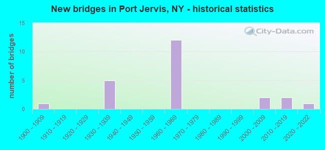
- New bridges - historical statistics
- 11900-1909
- 51930-1939
- 121960-1969
- 22000-2009
- 22010-2019
- 12020-2022
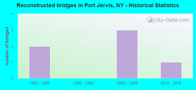
- Reconstructed bridges - Historical Statistics
- 21980-1989
- 01990-1999
- 32000-2009
- 12010-2019
- Bridge Condition - Deck
- 21.4%Excellent
- 14.3%Very good
- 14.3%Good
- 35.7%Satisfactory
- 7.1%Fair
- 7.1%Poor
- Bridge Condition - Superstructure
- 42.9%Excellent
- 7.1%Very good
- 21.4%Satisfactory
- 28.6%Fair
- Bridge Condition - Substructure
- 21.4%Excellent
- 7.1%Very good
- 14.3%Good
- 21.4%Satisfactory
- 21.4%Fair
- 7.1%Poor
- 7.1%Serious
- Bridge Condition - Channel
- 11.1%Excellent
- 11.1%Very good
- 33.3%Good
- 44.4%Satisfactory
Find on map >> Show street view
Structure Number: 1003081, Location: 3.2 MI E I84 INT 1 (Lat: 41.373494, Lng: -74.619953), Route carried "on" structure: Interstate 84, Year Built: 1964, Year Reconstructed: 2006, Status: Open, Structure Length: 4.63m (15.19ft), Average Daily Traffic: 16,379 (year 2009), Truck Traffic: 21%, Average Future Daily Traffic: 22,930 (year 2029), Design Load: HS 20, Features Intersected: RTE 6
Minimum Vertical Clearance: 30+ m (98+ ft), Kilometerpoint: 7.096, Lanes on structure: 2, Lanes under structure: 2, Base Highway Network: Yes, Owner: State Highway Agency, Approaching Roadway Width: 11.9m (39.0ft), Skew: 2 degrees, Material/Design: Steel, Design/Construction: Stringer/Multi-beam, Number Of Spans In Main Unit: 3, Length of Maximum Span: 17.6m (57.7ft), Curb-To-Curb Width: 11.6m (38.1ft), Out-to-Out Width: 12.6m (41.3ft)
Condition: Deck: Satisfactory, Superstructure: Satisfactory, Substructure: Poor, Operating Rating: 73.5 metric tons, Method Used To Determine Operating Rating: Load Factor (LF), Inventory Rating: 43.5 metric tons, Method Used To Determine Inventory Rating: Load Factor (LF), Structural Evaluation: Meets minimum limits, Deck Geometry: Equal to present minimum criteria, Underclear: Meets minimum limits, Approach Roadway Alignment: Equal to present desirable criteria, Length Of Structure Improvement: 4.63m (15.19ft), Designated Inspection Frequency: Every 24 months, Inspection Date: April 2021, Bridge Improvement Cost: $2,316,000, Roadway Improvement Cost: $1,356,000, Total Project Cost: $3,672,000 ( Estimate for 2021), Deck Structure Type: Concrete Cast-file-Place, Wearing Surface/Protective System: Wearing Surface: Integral Concrete
Find on map >> Show street view
Structure Number: 1003082, Location: 3.2 MI E I84 INT 1 (Lat: 41.373186, Lng: -74.619811), Route carried "on" structure: Interstate 84, Year Built: 1964, Year Reconstructed: 2006, Status: Open, Structure Length: 4.66m (15.29ft), Average Daily Traffic: 13,168 (year 2019), Truck Traffic: 24%, Average Future Daily Traffic: 23,085 (year 2040), Design Load: HS 20, Features Intersected: RTE 6
Minimum Vertical Clearance: 30+ m (98+ ft), Kilometerpoint: 7.112, Lanes on structure: 2, Lanes under structure: 2, Base Highway Network: Yes, Owner: State Highway Agency, Approaching Roadway Width: 12.2m (40.0ft), Material/Design: Steel, Design/Construction: Stringer/Multi-beam, Number Of Spans In Main Unit: 3, Length of Maximum Span: 16.4m (53.8ft), Curb-To-Curb Width: 11.6m (38.1ft), Out-to-Out Width: 12.6m (41.3ft)
Condition: Deck: Satisfactory, Superstructure: Satisfactory, Substructure: Serious, Operating Rating: 70.8 metric tons, Method Used To Determine Operating Rating: Load Factor (LF), Inventory Rating: 42.6 metric tons, Method Used To Determine Inventory Rating: Load Factor (LF), Structural Evaluation: High priority of corrective action, Deck Geometry: Equal to present minimum criteria, Underclear: Meets minimum limits, Approach Roadway Alignment: Equal to present desirable criteria, Length Of Structure Improvement: 4.66m (15.29ft), Designated Inspection Frequency: Every 24 months, Inspection Date: April 2021, Bridge Improvement Cost: $2,329,000, Roadway Improvement Cost: $1,364,000, Total Project Cost: $3,692,000 ( Estimate for 2021), Deck Structure Type: Concrete Cast-file-Place, Wearing Surface/Protective System: Wearing Surface: Integral Concrete
Find on map >> Show street view
Structure Number: 1032451, Location: EXIT 2 OF I84 (Lat: 41.373900, Lng: -74.613950), Route carried "on" structure: Interstate 84, Year Built: 1966, Year Reconstructed: 1993, Status: Open, Structure Length: 4.79m (15.72ft), Average Daily Traffic: 16,379 (year 2009), Truck Traffic: 21%, Design Load: HS 20, Features Intersected: COUNTY ROAD 35U
Minimum Vertical Clearance: 30+ m (98+ ft), Kilometerpoint: 7.562, Lanes on structure: 2, Lanes under structure: 2, Base Highway Network: Yes, Owner: State Highway Agency, Approaching Roadway Width: 11.6m (38.1ft), Skew: 1 degrees, Material/Design: Steel, Design/Construction: Stringer/Multi-beam, Number Of Spans In Main Unit: 3, Length of Maximum Span: 17.6m (57.7ft), Curb-To-Curb Width: 11.9m (39.0ft), Out-to-Out Width: 12.8m (42.0ft)
Condition: Deck: Satisfactory, Superstructure: Fair, Substructure: Fair, Operating Rating: 74.4 metric tons, Method Used To Determine Operating Rating: Load Factor (LF), Inventory Rating: 44.5 metric tons, Method Used To Determine Inventory Rating: Load Factor (LF), Structural Evaluation: Somewhat better than minimum adequacy, Deck Geometry: Equal to present minimum criteria, Underclear: Somewhat better than minimum adequacy, Approach Roadway Alignment: Equal to present desirable criteria, Length Of Structure Improvement: 4.78m (15.68ft), Designated Inspection Frequency: Every 24 months, Inspection Date: May 2021, Bridge Improvement Cost: $2,475,000, Roadway Improvement Cost: $1,449,000, Total Project Cost: $3,924,000 ( Estimate for 2021), Deck Structure Type: Concrete Cast-file-Place, Wearing Surface/Protective System: Wearing Surface: Monolithic Concrete
Find on map >> Show street view
Structure Number: 1032452, Location: EXIT 2 OF I84 (Lat: 41.373583, Lng: -74.614056), Route carried "on" structure: Interstate 84, Year Built: 1966, Year Reconstructed: 1993, Status: Open, Structure Length: 5.18m (16.99ft), Average Daily Traffic: 13,168 (year 2019), Truck Traffic: 25%, Average Future Daily Traffic: 23,085 (year 2040), Design Load: HS 20, Features Intersected: COUNTY ROAD 35U
Minimum Vertical Clearance: 30+ m (98+ ft), Kilometerpoint: 7.611, Lanes on structure: 2, Lanes under structure: 2, Base Highway Network: Yes, Owner: State Highway Agency, Approaching Roadway Width: 12.5m (41.0ft), Skew: 1 degrees, Material/Design: Steel, Design/Construction: Stringer/Multi-beam, Number Of Spans In Main Unit: 3, Length of Maximum Span: 20.1m (65.9ft), Curb-To-Curb Width: 11.9m (39.0ft), Out-to-Out Width: 12.8m (42.0ft)
Condition: Deck: Satisfactory, Superstructure: Fair, Substructure: Fair, Operating Rating: 69.9 metric tons, Method Used To Determine Operating Rating: Load Factor (LF), Inventory Rating: 41.7 metric tons, Method Used To Determine Inventory Rating: Load Factor (LF), Structural Evaluation: Somewhat better than minimum adequacy, Deck Geometry: Equal to present minimum criteria, Underclear: Somewhat better than minimum adequacy, Approach Roadway Alignment: Equal to present desirable criteria, Length Of Structure Improvement: 5.18m (16.99ft), Designated Inspection Frequency: Every 24 months, Inspection Date: May 2021, Bridge Improvement Cost: $2,646,000, Roadway Improvement Cost: $1,550,000, Total Project Cost: $4,196,000 ( Estimate for 2021), Deck Structure Type: Concrete Cast-file-Place, Wearing Surface/Protective System: Wearing Surface: Monolithic Concrete
Find on map >> Show street view
Structure Number: 1052401, Location: IN PORT JERVIS (Lat: 41.357164, Lng: -74.693478), Route carried "on" structure: Interstate 84, Year Built: 1967, Year Reconstructed: 2014, Status: Open, Structure Length: 38.19m (125.30ft), Average Daily Traffic: 14,404 (year 2013), Truck Traffic: 13%, Design Load: HL 93, Features Intersected: DELAWARE RIVER, NEVERSIN
Minimum Vertical Clearance: 30+ m (98+ ft), Kilometerpoint: 87.851, Lanes on structure: 2, Base Highway Network: Yes, Owner: State Highway Agency, Approaching Roadway Width: 10.4m (34.1ft), Skew: 1 degrees, Material/Design: Steel continuous, Design/Construction: Stringer/Multi-beam, Number Of Spans In Main Unit: 9, Length of Maximum Span: 42.4m (139.1ft), Curb-To-Curb Width: 10.4m (34.1ft), Out-to-Out Width: 11.4m (37.4ft)
Condition: Deck: Very good, Superstructure: Excellent, Substructure: Satisfactory, Channel: Good, Operating Rating: 83.5 metric tons, Method Used To Determine Operating Rating: Load Factor (LF), Inventory Rating: 49.9 metric tons, Method Used To Determine Inventory Rating: Load Factor (LF), Structural Evaluation: Equal to present minimum criteria, Deck Geometry: Meets minimum limits, Waterway Adequacy: Superior to present desirable criteria, Approach Roadway Alignment: Equal to present desirable criteria, Length Of Structure Improvement: 38.19m (125.30ft), Designated Inspection Frequency: Every 24 months, Underwater Inspection Frequency: Every 60 months, Inspection Date: September 2021, Underwater Inspection Date: May 2018, Bridge Improvement Cost: $15,397,000, Roadway Improvement Cost: $9,016,000, Total Project Cost: $24,413,000 ( Estimate for 2021), Deck Structure Type: Concrete Cast-file-Place, Wearing Surface/Protective System: Wearing Surface: Integral Concrete, Deck Protection: Other
Find on map >> Show street view
Structure Number: 1052402, Location: IN PORT JERVIS (Lat: 41.357258, Lng: -74.694231), Route carried "on" structure: Interstate 84, Year Built: 1967, Year Reconstructed: 2015, Status: Open, Structure Length: 38.19m (125.30ft), Average Daily Traffic: 13,159 (year 2019), Truck Traffic: 22%, Average Future Daily Traffic: 22,283 (year 2040), Design Load: HS 20, Features Intersected: DELAWARE RIVER, NEVERSIN
Minimum Vertical Clearance: 30+ m (98+ ft), Kilometerpoint: 0.000, Lanes on structure: 2, Base Highway Network: Yes, Owner: State Highway Agency, Approaching Roadway Width: 10.4m (34.1ft), Skew: 1 degrees, Material/Design: Steel continuous, Design/Construction: Stringer/Multi-beam, Number Of Spans In Main Unit: 9, Length of Maximum Span: 42.1m (138.1ft), Curb-To-Curb Width: 10.4m (34.1ft), Out-to-Out Width: 11.3m (37.1ft)
Condition: Deck: Excellent, Superstructure: Excellent, Substructure: Satisfactory, Channel: Good, Operating Rating: 49.9 metric tons, Method Used To Determine Operating Rating: Load and Resistance Factor Rating (LRFR) rating reported by rating factor(RF) method using HL-93 loadings, Inventory Rating: 38.6 metric tons, Method Used To Determine Inventory Rating: Load and Resistance Factor Rating (LRFR) rating reported by rating factor(RF) method using HL-93 loadings, Structural Evaluation: Equal to present minimum criteria, Deck Geometry: Meets minimum limits, Waterway Adequacy: Meets minimum limits, Approach Roadway Alignment: Equal to present desirable criteria, Length Of Structure Improvement: 38.19m (125.30ft), Designated Inspection Frequency: Every 24 months, Underwater Inspection Frequency: Every 60 months, Inspection Date: November 2021, Underwater Inspection Date: May 2018, Bridge Improvement Cost: $15,355,000, Roadway Improvement Cost: $8,992,000, Total Project Cost: $24,347,000 ( Estimate for 2021), Deck Structure Type: Concrete Cast-file-Place, Wearing Surface/Protective System: Wearing Surface: Integral Concrete, Deck Protection: Epoxy Coated Reinforcing
Find on map >> Show street view
Structure Number: 200305, Location: JCT US6 & NEVERSINK RIVER (Lat: 41.361275, Lng: -74.685428), Route carried "on" structure: US 6, Year Built: 2019, Status: Open, Structure Length: 4.56m (14.96ft), Average Daily Traffic: 13,872 (year 2020), Truck Traffic: 4%, Average Future Daily Traffic: 13,937 (year 2040), Design Load: HL 93, Features Intersected: NEVERSINK RIVER
Minimum Vertical Clearance: 32.69m (107.25ft), Kilometerpoint: 3.121, Lanes on structure: 3, Base Highway Network: Yes, Owner: City or Municipal Highway Agency, Approaching Roadway Width: 11.0m (36.1ft), Material/Design: Steel, Design/Construction: Stringer/Multi-beam, Number Of Spans In Main Unit: 1, Length of Maximum Span: 44.2m (145.0ft), Curb or Sidewalk Widths: Left: 1.5m (4.9ft), Right: 1.5m (4.9ft), Curb-To-Curb Width: 11.0m (36.1ft), Out-to-Out Width: 15.2m (49.9ft)
Condition: Deck: Good, Superstructure: Excellent, Substructure: Excellent, Channel: Very good, Operating Rating: 95.3 metric tons, Method Used To Determine Operating Rating: Load Factor (LF), Inventory Rating: 57.2 metric tons, Method Used To Determine Inventory Rating: Load Factor (LF), Structural Evaluation: Superior to present desirable criteria, Deck Geometry: High priority of replacement, Waterway Adequacy: Meets minimum limits, Approach Roadway Alignment: Meets minimum limits, Length Of Structure Improvement: 4.55m (14.93ft), Designated Inspection Frequency: Every 24 months, Inspection Date: October 2020, Bridge Improvement Cost: $3,340,000, Roadway Improvement Cost: $1,956,000, Total Project Cost: $5,297,000 ( Estimate for 2021), Deck Structure Type: Concrete Cast-file-Place, Wearing Surface/Protective System: Wearing Surface: Integral Concrete, Deck Protection: Epoxy Coated Reinforcing
Find on map >> Show street view
Structure Number: 200306, Location: JCT RTE 6 & CLOVE BROOK (Lat: 41.357531, Lng: -74.682606), Route carried "on" structure: US 6, Year Built: 2019, Status: Open, Structure Length: 1.43m (4.69ft), Average Daily Traffic: 13,872 (year 2020), Truck Traffic: 4%, Average Future Daily Traffic: 13,937 (year 2040), Design Load: HL 93, Features Intersected: CLOVE BROOK
Minimum Vertical Clearance: 30+ m (98+ ft), Kilometerpoint: 3.588, Lanes on structure: 2, Base Highway Network: Yes, Owner: City or Municipal Highway Agency, Approaching Roadway Width: 11.0m (36.1ft), Skew: 20 degrees, Material/Design: Concrete, Design/Construction: Frame, Number Of Spans In Main Unit: 1, Length of Maximum Span: 13.1m (43.0ft), Curb or Sidewalk Widths: Left: 0.0m, Right: 1.7m (5.6ft), Curb-To-Curb Width: 11.0m (36.1ft), Out-to-Out Width: 14.3m (46.9ft)
Condition: Deck: Excellent, Superstructure: Excellent, Substructure: Excellent, Channel: Excellent, Operating Rating: 74.4 metric tons, Method Used To Determine Operating Rating: Load Factor (LF), Inventory Rating: 44.5 metric tons, Method Used To Determine Inventory Rating: Load Factor (LF), Structural Evaluation: Superior to present desirable criteria, Deck Geometry: Meets minimum limits, Waterway Adequacy: Meets minimum limits, Approach Roadway Alignment: Superior to present desirable criteria, Length Of Structure Improvement: 1.43m (4.69ft), Designated Inspection Frequency: Every 24 months, Inspection Date: July 2020, Bridge Improvement Cost: $873,000, Roadway Improvement Cost: $511,000, Total Project Cost: $1,384,000 ( Estimate for 2021), Wearing Surface/Protective System: Wearing Surface: Bituminous
Find on map >> Show street view
Structure Number: 222368, Location: .7 MILE W OF PORT JERVIS (Lat: 41.378719, Lng: -74.698778), Route carried "on" structure: City street , Year Built: 2000, Status: Open, Structure Length: 5.03m (16.50ft), Average Daily Traffic: 2,230 (year 2020), Truck Traffic: 4%, Average Future Daily Traffic: 2,759 (year 2040), Design Load: HS 25 or greater, Features Intersected: MNRR PJ LINE, Facility Carried by Structure: WEST MAIN STREET
Minimum Vertical Clearance: 30+ m (98+ ft), Kilometerpoint: 0.853, Lanes on structure: 2, Owner: Railroad, Approaching Roadway Width: 9.1m (29.9ft), Skew: 1 degrees, Material/Design: Prestressed concrete continuous, Design/Construction: Box Beam or Girders - Multiple, Number Of Spans In Main Unit: 2, Length of Maximum Span: 24.3m (79.7ft), Curb or Sidewalk Widths: Left: 0.0m, Right: 1.5m (4.9ft), Curb-To-Curb Width: 9.0m (29.5ft), Out-to-Out Width: 12.0m (39.4ft)
Condition: Deck: Good, Superstructure: Excellent, Substructure: Very good, Inventory Rating: 63.5 metric tons, Method Used To Determine Inventory Rating: Load Factor (LF), Structural Evaluation: Equal to present desirable criteria, Deck Geometry: Meets minimum limits, Underclear: Better than present minimum criteria, Approach Roadway Alignment: Equal to present desirable criteria, Length Of Structure Improvement: 5.02m (16.47ft), Designated Inspection Frequency: Every 24 months, Inspection Date: August 2020, Bridge Improvement Cost: $1,451,000, Roadway Improvement Cost: $850,000, Total Project Cost: $2,300,000 ( Estimate for 2021), Deck Structure Type: Concrete Cast-file-Place, Wearing Surface/Protective System: Wearing Surface: Integral Concrete, Deck Protection: Epoxy Coated Reinforcing
Find on map >> Show street view
Structure Number: 222369, Location: AT PORT JERVIS (Lat: 41.377950, Lng: -74.678153), Route carried "on" structure: City street , Year Built: 1960, Status: Open, Structure Length: 0.70m (2.30ft), Average Daily Traffic: 1,451 (year 2018), Truck Traffic: 3%, Average Future Daily Traffic: 2,031 (year 2038), Features Intersected: COLD CREEK, Facility Carried by Structure: HAMILTON STREET
Minimum Vertical Clearance: 30+ m (98+ ft), Kilometerpoint: 0.837, Lanes on structure: 2, Owner: City or Municipal Highway Agency, Approaching Roadway Width: 7.9m (25.9ft), Material/Design: Concrete, Design/Construction: Culvert, Number Of Spans In Main Unit: 1, Length of Maximum Span: 6.4m (21.0ft), Curb or Sidewalk Widths: Left: 1.7m (5.6ft), Right: 2.0m (6.6ft), Curb-To-Curb Width: 7.9m (25.9ft), Out-to-Out Width: 12.2m (40.0ft)
Condition: Channel: Satisfactory, Culverts: Satisfactory, Operating Rating: 76.7 metric tons, Method Used To Determine Operating Rating: Field evaluation and documented engineering judgment, Inventory Rating: 29.4 metric tons, Method Used To Determine Inventory Rating: Field evaluation and documented engineering judgment, Structural Evaluation: Equal to present minimum criteria, Deck Geometry: Meets minimum limits, Waterway Adequacy: Equal to present desirable criteria, Approach Roadway Alignment: Equal to present desirable criteria, Length Of Structure Improvement: 0.70m (2.30ft), Designated Inspection Frequency: Every 24 months, Inspection Date: Febuary 2020, Bridge Improvement Cost: $366,000, Roadway Improvement Cost: $215,000, Total Project Cost: $581,000 ( Estimate for 2021), Wearing Surface/Protective System: Wearing Surface: Bituminous
Find on map >> Show street view
Structure Number: 22237, Location: AT PORT JERVIS (Lat: 41.381331, Lng: -74.680997), Route carried "on" structure: City street , Year Built: 1960, Status: Open, Structure Length: 0.67m (2.20ft), Average Daily Traffic: 719 (year 2019), Truck Traffic: 4%, Average Future Daily Traffic: 889 (year 2040), Features Intersected: SPILLWAY BROOK, Facility Carried by Structure: GLASS STREET
Minimum Vertical Clearance: 30+ m (98+ ft), Kilometerpoint: 0.145, Lanes on structure: 2, Owner: City or Municipal Highway Agency, Approaching Roadway Width: 10.4m (34.1ft), Material/Design: Concrete, Design/Construction: Slab, Number Of Spans In Main Unit: 1, Length of Maximum Span: 6.4m (21.0ft), Curb or Sidewalk Widths: Left: 2.3m (7.5ft), Right: 2.3m (7.5ft), Curb-To-Curb Width: 10.4m (34.1ft), Out-to-Out Width: 15.3m (50.2ft)
Condition: Deck: Satisfactory, Superstructure: Satisfactory, Substructure: Good, Channel: Satisfactory, Operating Rating: 77.1 metric tons, Method Used To Determine Operating Rating: Field evaluation and documented engineering judgment, Inventory Rating: 32.7 metric tons, Method Used To Determine Inventory Rating: Field evaluation and documented engineering judgment, Structural Evaluation: Equal to present minimum criteria, Deck Geometry: Equal to present minimum criteria, Waterway Adequacy: High priority of corrective action, Approach Roadway Alignment: Better than present minimum criteria, Length Of Structure Improvement: 0.67m (2.20ft), Designated Inspection Frequency: Every 24 months, Inspection Date: June 2020, Bridge Improvement Cost: $301,000, Roadway Improvement Cost: $176,000, Total Project Cost: $477,000 ( Estimate for 2021), Wearing Surface/Protective System: Wearing Surface: Bituminous
Find on map >> Show street view
Structure Number: 227062, Location: Front St.Over Pike St. (Lat: 41.374589, Lng: -74.693967), Route carried "on" structure: Business City street , Year Built: 1930, Status: Open, Structure Length: 2.07m (6.79ft), Average Daily Traffic: 6,947 (year 2016), Truck Traffic: 2%, Average Future Daily Traffic: 8,439 (year 2040), Features Intersected: Rt 209 WB, Rt 209 Pedest, Facility Carried by Structure: FRONT STREET
Minimum Vertical Clearance: 30+ m (98+ ft), Kilometerpoint: 0.000, Lanes on structure: 3, Lanes under structure: 4, Owner: City or Municipal Highway Agency, Approaching Roadway Width: 12.2m (40.0ft), Material/Design: Concrete, Design/Construction: Frame, Number Of Spans In Main Unit: 3, Length of Maximum Span: 7.9m (25.9ft), Curb or Sidewalk Widths: Left: 2.1m (6.9ft), Right: 0.0m, Curb-To-Curb Width: 12.2m (40.0ft), Out-to-Out Width: 15.2m (49.9ft)
Condition: Deck: Fair, Superstructure: Fair, Substructure: Fair, Operating Rating: 67.2 metric tons, Method Used To Determine Operating Rating: Field evaluation and documented engineering judgment, Inventory Rating: 18.3 metric tons, Method Used To Determine Inventory Rating: Field evaluation and documented engineering judgment, Structural Evaluation: Meets minimum limits, Deck Geometry: Meets minimum limits, Underclear: High priority of corrective action, Approach Roadway Alignment: High priority of corrective action, Length Of Structure Improvement: 2.07m (6.79ft), Designated Inspection Frequency: Every 24 months, Inspection Date: July 2020, Bridge Improvement Cost: $2,414,000, Roadway Improvement Cost: $1,414,000, Total Project Cost: $3,828,000 ( Estimate for 2021), Wearing Surface/Protective System: Wearing Surface: Bituminous
Find on map >> Show street view
Structure Number: 227127, Location: JCT RTE 6 & CLOVE BROOK (Lat: 41.357219, Lng: -74.682342), Route carried "on" structure: US 6, Year Built: 2020, Status: Open, Structure Length: 0.98m (3.22ft), Average Daily Traffic: 13,872 (year 2020), Truck Traffic: 4%, Average Future Daily Traffic: 13,937 (year 2040), Design Load: HL 93, Features Intersected: Clove Brook
Minimum Vertical Clearance: 32.69m (107.25ft), Kilometerpoint: 3.636, Lanes on structure: 3, Owner: City or Municipal Highway Agency, Approaching Roadway Width: 13.7m (44.9ft), Material/Design: Concrete, Design/Construction: Frame, Number Of Spans In Main Unit: 1, Length of Maximum Span: 9.1m (29.9ft), Curb or Sidewalk Widths: Left: 0.0m, Right: 1.5m (4.9ft), Curb-To-Curb Width: 11.0m (36.1ft), Out-to-Out Width: 13.7m (44.9ft)
Condition: Deck: Excellent, Superstructure: Excellent, Substructure: Excellent, Channel: Good, Inventory Rating: 60.8 metric tons, Method Used To Determine Inventory Rating: Load Factor (LF), Structural Evaluation: Superior to present desirable criteria, Deck Geometry: High priority of replacement, Waterway Adequacy: Meets minimum limits, Approach Roadway Alignment: Equal to present desirable criteria, Length Of Structure Improvement: 0.97m (3.18ft), Designated Inspection Frequency: Every 24 months, Inspection Date: October 2020, Bridge Improvement Cost: $801,000, Roadway Improvement Cost: $469,000, Total Project Cost: $1,270,000 ( Estimate for 2021)
Find on map >> Show street view
Structure Number: 334447, Location: 0.6 MI S OF PORT JERVIS (Lat: 41.359378, Lng: -74.685669), Route carried "on" structure: Business County highway , Year Built: 2000, Status: Open, Structure Length: 0.88m (2.89ft), Average Daily Traffic: 1,731 (year 2020), Truck Traffic: 8%, Average Future Daily Traffic: 2,102 (year 2040), Design Load: HS 25 or greater, Features Intersected: MILL BROOK, Facility Carried by Structure: SOUTH MAPLE AVENUE
Minimum Vertical Clearance: 30+ m (98+ ft), Kilometerpoint: 0.145, Lanes on structure: 2, Owner: County Highway Agency, Approaching Roadway Width: 8.5m (27.9ft), Material/Design: Concrete, Design/Construction: Frame, Number Of Spans In Main Unit: 1, Length of Maximum Span: 8.5m (27.9ft), Curb or Sidewalk Widths: Left: 1.6m (5.2ft), Right: 1.6m (5.2ft), Curb-To-Curb Width: 9.1m (29.9ft), Out-to-Out Width: 13.2m (43.3ft)
Condition: Deck: Very good, Superstructure: Very good, Substructure: Good, Channel: Satisfactory, Operating Rating: 98.0 metric tons, Method Used To Determine Operating Rating: Load Factor (LF), Inventory Rating: 58.8 metric tons, Method Used To Determine Inventory Rating: Load Factor (LF), Structural Evaluation: Better than present minimum criteria, Deck Geometry: Somewhat better than minimum adequacy, Waterway Adequacy: Equal to present desirable criteria, Approach Roadway Alignment: Equal to present desirable criteria, Length Of Structure Improvement: 0.88m (2.89ft), Designated Inspection Frequency: Every 24 months, Inspection Date: July 2020, Bridge Improvement Cost: $782,000, Roadway Improvement Cost: $458,000, Total Project Cost: $1,240,000 ( Estimate for 2021), Wearing Surface/Protective System: Wearing Surface: Bituminous
Find on map >> Show street view
Structure Number: 522306, Location: PORT JERVIS PIKE ST (Lat: 41.371739, Lng: -74.697158), Route carried "on" structure: US 6, Year Built: 1939, Status: Open, Structure Length: 20.09m (65.91ft), Average Daily Traffic: 15,440 (year 2022), Truck Traffic: 3%, Average Future Daily Traffic: 18,301 (year 2032), Design Load: HS 20, Features Intersected: DELAWARE RIVER
Minimum Vertical Clearance: 5.18m (16.99ft), Kilometerpoint: 49.103, Lanes on structure: 2, Base Highway Network: Yes, Owner: State Highway Agency, Approaching Roadway Width: 13.4m (44.0ft), Material/Design: Steel, Design/Construction: Truss - Thru, Number Of Spans In Main Unit: 2, Length of Maximum Span: 99.1m (325.1ft), Curb or Sidewalk Widths: Left: 1.5m (4.9ft), Right: 1.5m (4.9ft), Curb-To-Curb Width: 13.4m (44.0ft), Out-to-Out Width: 14.0m (45.9ft)
Condition: Deck: Poor, Superstructure: Fair, Substructure: Satisfactory, Channel: Satisfactory, Operating Rating: 54.4 metric tons, Method Used To Determine Operating Rating: Load Factor (LF), Inventory Rating: 32.7 metric tons, Method Used To Determine Inventory Rating: Load Factor (LF), Structural Evaluation: Somewhat better than minimum adequacy, Deck Geometry: Equal to present minimum criteria, Waterway Adequacy: Superior to present desirable criteria, Approach Roadway Alignment: Equal to present desirable criteria, Length Of Structure Improvement: 20.50m (67.26ft), Designated Inspection Frequency: Every 24 months, Critical Feature Inspection Frequency: Every 24 months, Underwater Inspection Frequency: Every 60 months, Other Special Inspection Frequency: Every 6 months, Inspection Date: June 2021, Critical Feature Inspection Date: June 2021, Underwater Inspection Date: December 2020, Other Special Inspection Date: June 2021, Bridge Improvement Cost: $221,000, Roadway Improvement Cost: $651,000, Total Project Cost: $2,982,000, Deck Structure Type: Open Grating
Find on map >> Show street view
Structure Number: 1003081, Location: 3.2 MI E I84 INT 1 (Lat: 41.373494, Lng: -74.619953), Route carried "under" structure: US 6, Year Built: 1964, Structure Length: 0. m, Average Daily Traffic: 2,387 (year 1999), Features Intersected: RTE 6, Facility Carried by Structure: RTE I84
Minimum Vertical Clearance: 8.00m (26.25ft), Kilometerpoint: 6.130, Lanes on structure: 2, Lanes under structure: 2, Material/Design: Steel, Design/Construction: Stringer/Multi-beam, Length of Maximum Span: 17.6m (57.7ft)
Find on map >> Show street view
Structure Number: 1003082, Location: 3.2 MI E I84 INT 1 (Lat: 41.373186, Lng: -74.619811), Route carried "under" structure: US 6, Year Built: 1964, Structure Length: 0. m, Average Daily Traffic: 2,387 (year 1999), Features Intersected: RTE 6, Facility Carried by Structure: RTE I84
Minimum Vertical Clearance: 8.38m (27.49ft), Kilometerpoint: 6.130, Lanes on structure: 2, Lanes under structure: 2, Material/Design: Steel, Design/Construction: Stringer/Multi-beam, Length of Maximum Span: 16.4m (53.8ft)
Find on map >> Show street view
Structure Number: 1032451, Location: EXIT 2 OF I84 (Lat: 41.373900, Lng: -74.613950), Route carried "under" structure: County highway , Year Built: 1966, Structure Length: 0. m, Average Daily Traffic: 2,500 (year 2019), Truck Traffic: 7%, Features Intersected: COUNTY ROAD 35U, Facility Carried by Structure: RTE I84
Minimum Vertical Clearance: 4.52m (14.83ft), Kilometerpoint: 0.418, Lanes on structure: 2, Lanes under structure: 2, Material/Design: Steel, Design/Construction: Stringer/Multi-beam, Length of Maximum Span: 17.6m (57.7ft)
Find on map >> Show street view
Structure Number: 1032452, Location: EXIT 2 OF I84 (Lat: 41.373583, Lng: -74.614056), Route carried "under" structure: County highway , Year Built: 1966, Structure Length: 0. m, Average Daily Traffic: 2,500 (year 2019), Truck Traffic: 7%, Features Intersected: COUNTY ROAD 35U, Facility Carried by Structure: RTE I84
Minimum Vertical Clearance: 6.04m (19.82ft), Kilometerpoint: 0.000, Lanes on structure: 2, Lanes under structure: 2, Material/Design: Steel, Design/Construction: Stringer/Multi-beam, Length of Maximum Span: 20.1m (65.9ft)
Find on map >> Show street view
Structure Number: 227062, Location: Front St.Over Pike St. (Lat: 41.374589, Lng: -74.693967), Route carried "under" structure: Business City street , Year Built: 1930, Structure Length: 0. m, Average Daily Traffic: 10,458 (year 2014), Features Intersected: Rt 209 WB, Rt 209 Pedest, Facility Carried by Structure: FRONT STREET
Minimum Vertical Clearance: 4.34m (14.24ft), Kilometerpoint: 0.000, Lanes on structure: 3, Lanes under structure: 2, Material/Design: Concrete, Design/Construction: Frame, Length of Maximum Span: 7.9m (25.9ft)
Find on map >> Show street view
Structure Number: 700303, Location: IN PORT JERVIS (Lat: 41.374417, Lng: -74.694186), Route carried "under" structure: US 6, Year Built: 1936, Structure Length: 0. m, Average Daily Traffic: 12,400 (year 1979), Features Intersected: RTE 6, Facility Carried by Structure: MNRR PJ LINE
Minimum Vertical Clearance: 4.16m (13.65ft), Kilometerpoint: 1.384, Lanes under structure: 4, Material/Design: Concrete, Design/Construction: Frame, Length of Maximum Span: 7.9m (25.9ft)
Find on map >> Show street view
Structure Number: 700304, Location: SOUTH SIDE OF PORT JERVIS (Lat: 41.363406, Lng: -74.684800), Route carried "under" structure: US 6, Year Built: 1936, Structure Length: 0. m, Average Daily Traffic: 900 (year 1982), Features Intersected: RTE 6, Facility Carried by Structure: MNRR PJ LINE
Minimum Vertical Clearance: 4.03m (13.22ft), Kilometerpoint: 2.880, Lanes under structure: 2, Material/Design: Steel, Design/Construction: Girder and Floorbeam System, Length of Maximum Span: 12.8m (42.0ft)
Find on map >> Show street view
Structure Number: 771289, Location: IN TRISTATES (Lat: 41.361694, Lng: -74.682308), Route carried "under" structure: City street , Year Built: 1905, Structure Length: 0. m, Average Daily Traffic: 2,677 (year 2018), Truck Traffic: 6%, Features Intersected: NORTH MAPLE AVE, Facility Carried by Structure: MNRR PJ LINE
Minimum Vertical Clearance: 3.81m (12.50ft), Kilometerpoint: 0.000, Lanes under structure: 1, Material/Design: Masonry, Design/Construction: Arch - Deck, Length of Maximum Span: 6.7m (22.0ft)