Bridge Statistics for Port Matilda, Pennsylvania (PA)
Condition, Traffic, Stress, Structural Evaluation, Project Costs
- National Bridge Inventory (NBI) Statistics
- 29Number of bridges
- 381ft / 116mTotal length
- $2,008,000Total costs
- 110,077Total average daily traffic
- 14,240Total average daily truck traffic
- National Bridge Inventory (NBI) Registered Bridges for Port Matilda
- No street view available for this location
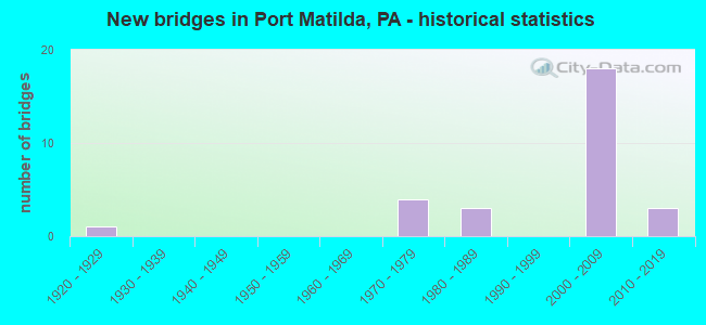
- New bridges - historical statistics
- 11920-1929
- 41970-1979
- 31980-1989
- 182000-2009
- 32010-2019

- Reconstructed bridges - Historical Statistics
- 11940-1949
- 01950-1959
- 01960-1969
- 01970-1979
- 11980-1989
- 01990-1999
- 12000-2009


- Bridge Condition - Deck
- 15.8%Very good
- 57.9%Good
- 15.8%Satisfactory
- 5.3%Fair
- 5.3%Poor

- Bridge Condition - Superstructure
- 10.5%Excellent
- 42.1%Very good
- 26.3%Good
- 5.3%Satisfactory
- 10.5%Fair
- 5.3%Poor

- Bridge Condition - Substructure
- 5.3%Excellent
- 21.1%Very good
- 52.6%Good
- 10.5%Satisfactory
- 10.5%Fair

- Bridge Condition - Channel
- 9.1%Excellent
- 45.5%Very good
- 18.2%Good
- 9.1%Satisfactory
- 18.2%Fair
Find on map >> Show street view
Structure Number: 9428, Location: HANNAH (Lat: 40.785292, Lng: -78.074036), Route carried "on" structure: US 220B, Year Built: 1925, Year Reconstructed: 1952, Status: Open, Structure Length: 1.28m (4.20ft), Average Daily Traffic: 1,286 (year 2021), Truck Traffic: 8%, Average Future Daily Traffic: 2,036 (year 2040), Design Load: H 15, Features Intersected: REESE HOLLOW, Facility Carried by Structure: SR 220-US 220
Minimum Vertical Clearance: 30+ m (98+ ft), Kilometerpoint: 6.471, Lanes on structure: 2, Owner: State Highway Agency, Approaching Roadway Width: 9.1m (29.9ft), Material/Design: Concrete, Design/Construction: Slab, Number Of Spans In Main Unit: 2, Length of Maximum Span: 5.8m (19.0ft), Curb-To-Curb Width: 11.6m (38.1ft), Out-to-Out Width: 13.4m (44.0ft)
Condition: Deck: Fair, Superstructure: Fair, Substructure: Fair, Channel: Fair, Operating Rating: 73.5 metric tons, Method Used To Determine Operating Rating: Field evaluation and documented engineering judgment, Inventory Rating: 44.5 metric tons, Method Used To Determine Inventory Rating: Field evaluation and documented engineering judgment, Structural Evaluation: Somewhat better than minimum adequacy, Deck Geometry: Equal to present minimum criteria, Waterway Adequacy: Equal to present minimum criteria, Approach Roadway Alignment: Equal to present desirable criteria, Length Of Structure Improvement: 1.30m (4.27ft), Designated Inspection Frequency: Every 24 months, Inspection Date: May 2020, Bridge Improvement Cost: $34,000, Roadway Improvement Cost: $250,000, Total Project Cost: $461,000, Deck Structure Type: Concrete Cast-file-Place, Wearing Surface/Protective System: Wearing Surface: Bituminous
Find on map >> Show street view
Structure Number: 9477, Location: 3 MI NW PORT MATILDA (Lat: 40.825314, Lng: -78.098608), Route carried "on" structure: US 322, Year Built: 1971, Year Reconstructed: 1980, Status: Open, Structure Length: 4.24m (13.91ft), Average Daily Traffic: 4,209 (year 2020), Truck Traffic: 11%, Average Future Daily Traffic: 5,765 (year 2040), Design Load: HS 20, Features Intersected: TOWNSHIP ROAD
Minimum Vertical Clearance: 30+ m (98+ ft), Kilometerpoint: 15.023, Lanes on structure: 2, Lanes under structure: 2, Base Highway Network: Yes, Owner: State Highway Agency, Approaching Roadway Width: 11.6m (38.1ft), Skew: 2 degrees, Material/Design: Prestressed concrete, Design/Construction: Box Beam or Girders - Single/Spread, Number Of Spans In Main Unit: 3, Length of Maximum Span: 16.2m (53.1ft), Curb or Sidewalk Widths: Left: 0.2m (0.7ft), Right: 0.2m (0.7ft), Curb-To-Curb Width: 12.0m (39.4ft), Out-to-Out Width: 13.2m (43.3ft)
Condition: Deck: Satisfactory, Superstructure: Fair, Substructure: Satisfactory, Operating Rating: 44.5 metric tons, Method Used To Determine Operating Rating: Load Factor (LF), Inventory Rating: 26.3 metric tons, Method Used To Determine Inventory Rating: Load Factor (LF), Structural Evaluation: Somewhat better than minimum adequacy, Deck Geometry: Better than present minimum criteria, Underclear: Equal to present minimum criteria, Approach Roadway Alignment: Equal to present desirable criteria, Length Of Structure Improvement: 4.20m (13.78ft), Designated Inspection Frequency: Every 24 months, Inspection Date: May 2020, Bridge Improvement Cost: $115,000, Roadway Improvement Cost: $337,000, Total Project Cost: $1,547,000, Deck Structure Type: Concrete Cast-file-Place, Wearing Surface/Protective System: Wearing Surface: Latex Concrete
Find on map >> Show street view
Structure Number: 9478, Location: 1 MI NW PORT MATILDA (Lat: 40.809806, Lng: -78.072731), Route carried "on" structure: State highway , Year Built: 1971, Year Reconstructed: 2005, Status: Open, Structure Length: 1.10m (3.61ft), Average Daily Traffic: 1,652 (year 2021), Truck Traffic: 7%, Average Future Daily Traffic: 3,882 (year 2040), Design Load: HS 20, Features Intersected: LAUREL RUN, Facility Carried by Structure: SR 3042
Minimum Vertical Clearance: 30+ m (98+ ft), Kilometerpoint: 0.222, Lanes on structure: 2, Base Highway Network: Yes, Owner: State Highway Agency, Approaching Roadway Width: 8.8m (28.9ft), Skew: 5 degrees, Material/Design: Prestressed concrete, Design/Construction: Box Beam or Girders - Single/Spread, Number Of Spans In Main Unit: 1, Length of Maximum Span: 10.4m (34.1ft), Curb or Sidewalk Widths: Left: 0.2m (0.7ft), Right: 0.2m (0.7ft), Curb-To-Curb Width: 13.4m (44.0ft), Out-to-Out Width: 14.6m (47.9ft)
Condition: Deck: Satisfactory, Superstructure: Satisfactory, Substructure: Fair, Channel: Satisfactory, Operating Rating: 78.0 metric tons, Method Used To Determine Operating Rating: Load Factor (LF), Inventory Rating: 34.5 metric tons, Method Used To Determine Inventory Rating: Load Factor (LF), Structural Evaluation: Somewhat better than minimum adequacy, Deck Geometry: Equal to present desirable criteria, Waterway Adequacy: Equal to present minimum criteria, Approach Roadway Alignment: Equal to present desirable criteria, Length Of Structure Improvement: 1.10m (3.61ft), Designated Inspection Frequency: Every 24 months, Inspection Date: May 2020, Deck Structure Type: Concrete Cast-file-Place, Wearing Surface/Protective System: Wearing Surface: Monolithic Concrete
Find on map >> Show street view
Structure Number: 9479, Location: MARTHA FURNACE (Lat: 40.799611, Lng: -78.054556), Route carried "on" structure: State highway , Year Built: 1987, Status: Open, Structure Length: 4.57m (14.99ft), Average Daily Traffic: 2,514 (year 2021), Truck Traffic: 5%, Average Future Daily Traffic: 3,346 (year 2041), Design Load: HS 20+Mod, Features Intersected: SR 3040, Facility Carried by Structure: SR 3042
Minimum Vertical Clearance: 30+ m (98+ ft), Kilometerpoint: 2.148, Lanes on structure: 2, Lanes under structure: 4, Base Highway Network: Yes, Owner: State Highway Agency, Approaching Roadway Width: 7.9m (25.9ft), Skew: 32 degrees, Material/Design: Prestressed concrete continuous, Design/Construction: Box Beam or Girders - Multiple, Number Of Spans In Main Unit: 2, Length of Maximum Span: 22.6m (74.1ft), Curb or Sidewalk Widths: Left: 0.2m (0.7ft), Right: 0.2m (0.7ft), Curb-To-Curb Width: 8.1m (26.6ft), Out-to-Out Width: 17.9m (58.7ft)
Condition: Deck: Good, Superstructure: Very good, Substructure: Good, Operating Rating: 83.5 metric tons, Method Used To Determine Operating Rating: Load Factor (LF), Inventory Rating: 34.5 metric tons, Method Used To Determine Inventory Rating: Load Factor (LF), Structural Evaluation: Better than present minimum criteria, Deck Geometry: High priority of corrective action, Underclear: Equal to present minimum criteria, Approach Roadway Alignment: Equal to present desirable criteria, Length Of Structure Improvement: 4.60m (15.09ft), Designated Inspection Frequency: Every 24 months, Inspection Date: June 2021, Deck Structure Type: Concrete Cast-file-Place, Wearing Surface/Protective System: Wearing Surface: Epoxy Overlay, Deck Protection: Epoxy Coated Reinforcing
Find on map >> Show street view
Structure Number: 9849, Location: 2 MI. WNW OF PORT MATILDA (Lat: 40.813122, Lng: -78.089347), Route carried "on" structure: City street , Year Built: 1972, Status: Posted for load, Structure Length: 0.76m (2.49ft), Average Daily Traffic: 25 (year 2021), Average Future Daily Traffic: 37 (year 2043), Design Load: HS 20, Features Intersected: LAUREL RUN, Facility Carried by Structure: T-312 SHADYDELLRD
Minimum Vertical Clearance: 30+ m (98+ ft), Kilometerpoint: 0.000, Lanes on structure: 2, Owner: Town or Township Highway Agency, Approaching Roadway Width: 5.5m (18.0ft), Material/Design: Prestressed concrete, Design/Construction: Slab, Number Of Spans In Main Unit: 1, Length of Maximum Span: 7.3m (24.0ft), Curb or Sidewalk Widths: Left: 0.1m (0.3ft), Right: 0.1m (0.3ft), Curb-To-Curb Width: 5.9m (19.4ft), Out-to-Out Width: 6.2m (20.3ft)
Condition: Deck: Poor, Superstructure: Poor, Substructure: Satisfactory, Channel: Fair, Operating Rating: 49.0 metric tons, Method Used To Determine Operating Rating: Load Factor (LF), Inventory Rating: 24.5 metric tons, Method Used To Determine Inventory Rating: Load Factor (LF), Structural Evaluation: Meets minimum limits, Deck Geometry: Meets minimum limits, Waterway Adequacy: Better than present minimum criteria, Approach Roadway Alignment: Equal to present desirable criteria, Length Of Structure Improvement: 1.50m (4.92ft), Designated Inspection Frequency: Every 24 months, Other Special Inspection Frequency: Every 12 months, Inspection Date: June 2021, Other Special Inspection Date: June 2021, Wearing Surface/Protective System: Wearing Surface: Gravel
Find on map >> Show street view
Structure Number: 4211, Location: 2 MILES WEST PORT MATILDA (Lat: 40.807417, Lng: -78.061817), Route carried "on" structure: Interstate 99, Year Built: 2003, Status: Open, Structure Length: 20.70m (67.91ft), Average Daily Traffic: 7,491 (year 2021), Truck Traffic: 18%, Average Future Daily Traffic: 9,605 (year 2040), Design Load: H 20, Features Intersected: LAUREL AND OLIVER RUNS
Minimum Vertical Clearance: 30+ m (98+ ft), Kilometerpoint: 8.884, Lanes on structure: 3, Base Highway Network: Yes, Owner: State Highway Agency, Approaching Roadway Width: 10.4m (34.1ft), Skew: 11 degrees, Material/Design: Prestressed concrete continuous, Design/Construction: Stringer/Multi-beam, Number Of Spans In Main Unit: 6, Length of Maximum Span: 38.1m (125.0ft), Curb or Sidewalk Widths: Left: 0.1m (0.3ft), Right: 0.1m (0.3ft), Curb-To-Curb Width: 17.9m (58.7ft), Out-to-Out Width: 18.7m (61.4ft)
Condition: Deck: Good, Superstructure: Very good, Substructure: Good, Channel: Excellent, Inventory Rating: 52.6 metric tons, Method Used To Determine Inventory Rating: Load Factor (LF), Structural Evaluation: Better than present minimum criteria, Deck Geometry: Better than present minimum criteria, Waterway Adequacy: Superior to present desirable criteria, Approach Roadway Alignment: Equal to present desirable criteria, Length Of Structure Improvement: 21.30m (69.88ft), Designated Inspection Frequency: Every 24 months, Inspection Date: July 2020, Deck Structure Type: Concrete Cast-file-Place, Wearing Surface/Protective System: Wearing Surface: Monolithic Concrete, Deck Protection: Epoxy Coated Reinforcing
Find on map >> Show street view
Structure Number: 42116, Location: 1 MILE NORTH PORT MATILDA (Lat: 40.804089, Lng: -78.063842), Route carried "on" structure: Interstate 99, Year Built: 2003, Status: Open, Structure Length: 5.24m (17.19ft), Average Daily Traffic: 7,491 (year 2021), Truck Traffic: 18%, Average Future Daily Traffic: 9,605 (year 2040), Design Load: HS 25 or greater, Features Intersected: SR 3042
Minimum Vertical Clearance: 30+ m (98+ ft), Kilometerpoint: 8.884, Lanes on structure: 2, Lanes under structure: 2, Base Highway Network: Yes, Owner: State Highway Agency, Approaching Roadway Width: 12.2m (40.0ft), Skew: 11 degrees, Material/Design: Prestressed concrete continuous, Design/Construction: Stringer/Multi-beam, Number Of Spans In Main Unit: 3, Length of Maximum Span: 26.8m (87.9ft), Curb or Sidewalk Widths: Left: 0.2m (0.7ft), Right: 0.2m (0.7ft), Curb-To-Curb Width: 12.2m (40.0ft), Out-to-Out Width: 13.0m (42.7ft)
Condition: Deck: Good, Superstructure: Very good, Substructure: Very good, Operating Rating: 91.6 metric tons, Method Used To Determine Operating Rating: Load Factor (LF), Inventory Rating: 29.9 metric tons, Method Used To Determine Inventory Rating: Load Factor (LF), Structural Evaluation: Better than present minimum criteria, Deck Geometry: Better than present minimum criteria, Underclear: Equal to present minimum criteria, Approach Roadway Alignment: Equal to present desirable criteria, Length Of Structure Improvement: 6.20m (20.34ft), Designated Inspection Frequency: Every 24 months, Inspection Date: July 2020, Deck Structure Type: Concrete Cast-file-Place, Wearing Surface/Protective System: Wearing Surface: Monolithic Concrete, Deck Protection: Epoxy Coated Reinforcing
Find on map >> Show street view
Structure Number: 42129, Location: 1 MILE EAST PORT MATILDA (Lat: 40.810117, Lng: -78.038119), Route carried "on" structure: Interstate 99, Year Built: 2003, Status: Open, Structure Length: 9.97m (32.71ft), Average Daily Traffic: 11,627 (year 2021), Truck Traffic: 15%, Average Future Daily Traffic: 14,635 (year 2040), Design Load: HS 25 or greater, Features Intersected: SEDA-COG/NIT&BALD EGL RR
Minimum Vertical Clearance: 30+ m (98+ ft), Kilometerpoint: 11.336, Lanes on structure: 3, Base Highway Network: Yes, Owner: State Highway Agency, Approaching Roadway Width: 13.7m (44.9ft), Skew: 10 degrees, Material/Design: Prestressed concrete continuous, Design/Construction: Stringer/Multi-beam, Number Of Spans In Main Unit: 3, Length of Maximum Span: 37.8m (124.0ft), Curb or Sidewalk Widths: Left: 0.2m (0.7ft), Right: 0.2m (0.7ft), Curb-To-Curb Width: 14.3m (46.9ft), Out-to-Out Width: 16.6m (54.5ft)
Condition: Deck: Satisfactory, Superstructure: Good, Substructure: Good, Inventory Rating: 30.8 metric tons, Method Used To Determine Inventory Rating: Load Factor (LF), Structural Evaluation: Better than present minimum criteria, Deck Geometry: Meets minimum limits, Underclear: High priority of corrective action, Approach Roadway Alignment: Equal to present desirable criteria, Length Of Structure Improvement: 10.90m (35.76ft), Designated Inspection Frequency: Every 24 months, Inspection Date: July 2020, Deck Structure Type: Concrete Cast-file-Place, Wearing Surface/Protective System: Wearing Surface: Monolithic Concrete, Deck Protection: Epoxy Coated Reinforcing
Find on map >> Show street view
Structure Number: 42364, Location: 2 MILE NORTH PORT MATILDA (Lat: 40.810989, Lng: -78.075711), Route carried "on" structure: US 322, Year Built: 2004, Status: Open, Structure Length: 18.14m (59.51ft), Average Daily Traffic: 4,834 (year 2021), Truck Traffic: 9%, Average Future Daily Traffic: 5,074 (year 2040), Design Load: HL 93, Features Intersected: SR 3042 / OLIVER RUN
Minimum Vertical Clearance: 30+ m (98+ ft), Kilometerpoint: 18.277, Lanes on structure: 2, Lanes under structure: 2, Base Highway Network: Yes, Owner: State Highway Agency, Approaching Roadway Width: 11.6m (38.1ft), Skew: 10 degrees, Material/Design: Prestressed concrete continuous, Design/Construction: Stringer/Multi-beam, Number Of Spans In Main Unit: 6, Length of Maximum Span: 31.1m (102.0ft), Curb or Sidewalk Widths: Left: 0.1m (0.3ft), Right: 0.1m (0.3ft), Curb-To-Curb Width: 12.2m (40.0ft), Out-to-Out Width: 13.0m (42.7ft)
Condition: Deck: Good, Superstructure: Good, Substructure: Good, Channel: Very good, Operating Rating: 97.1 metric tons, Method Used To Determine Operating Rating: Load Factor (LF), Inventory Rating: 43.5 metric tons, Method Used To Determine Inventory Rating: Load Factor (LF), Structural Evaluation: Better than present minimum criteria, Deck Geometry: Better than present minimum criteria, Underclear: Somewhat better than minimum adequacy, Waterway Adequacy: Superior to present desirable criteria, Approach Roadway Alignment: Equal to present desirable criteria, Length Of Structure Improvement: 18.90m (62.01ft), Designated Inspection Frequency: Every 24 months, Inspection Date: July 2020, Deck Structure Type: Concrete Cast-file-Place, Wearing Surface/Protective System: Wearing Surface: Monolithic Concrete, Deck Protection: Epoxy Coated Reinforcing
Find on map >> Show street view
Structure Number: 42365, Location: 2 MILE NORTH PORT MATILDA (Lat: 40.811206, Lng: -78.072297), Route carried "on" structure: US 322, Year Built: 2004, Status: Open, Structure Length: 16.31m (53.51ft), Average Daily Traffic: 5,085 (year 2021), Truck Traffic: 10%, Average Future Daily Traffic: 4,910 (year 2040), Design Load: HL 93, Features Intersected: SR 3042 / OLIVER RUN
Minimum Vertical Clearance: 30+ m (98+ ft), Kilometerpoint: 18.242, Lanes on structure: 2, Lanes under structure: 2, Base Highway Network: Yes, Owner: State Highway Agency, Approaching Roadway Width: 11.6m (38.1ft), Skew: 10 degrees, Material/Design: Prestressed concrete continuous, Design/Construction: Stringer/Multi-beam, Number Of Spans In Main Unit: 5, Length of Maximum Span: 32.6m (107.0ft), Curb or Sidewalk Widths: Left: 0.1m (0.3ft), Right: 0.1m (0.3ft), Curb-To-Curb Width: 12.2m (40.0ft), Out-to-Out Width: 13.0m (42.7ft)
Condition: Deck: Good, Superstructure: Good, Substructure: Good, Channel: Very good, Inventory Rating: 42.6 metric tons, Method Used To Determine Inventory Rating: Load Factor (LF), Structural Evaluation: Better than present minimum criteria, Deck Geometry: Better than present minimum criteria, Underclear: Somewhat better than minimum adequacy, Waterway Adequacy: Superior to present desirable criteria, Approach Roadway Alignment: Equal to present desirable criteria, Length Of Structure Improvement: 17.10m (56.10ft), Designated Inspection Frequency: Every 24 months, Inspection Date: July 2020, Deck Structure Type: Concrete Cast-file-Place, Wearing Surface/Protective System: Wearing Surface: Monolithic Concrete, Deck Protection: Epoxy Coated Reinforcing
Find on map >> Show street view
Structure Number: 42494, Location: 2 MI NW. PORT MATILDA (Lat: 40.812150, Lng: -78.072742), Route carried "on" structure: State highway , Year Built: 2004, Status: Open, Structure Length: 0.91m (2.99ft), Average Daily Traffic: 859 (year 2021), Truck Traffic: 11%, Average Future Daily Traffic: 1,278 (year 2040), Design Load: HS 20, Features Intersected: OLIVER RUN, Facility Carried by Structure: SR 3042
Minimum Vertical Clearance: 30+ m (98+ ft), Kilometerpoint: 0.000, Lanes on structure: 2, Base Highway Network: Yes, Owner: State Highway Agency, Approaching Roadway Width: 9.8m (32.2ft), Material/Design: Concrete, Design/Construction: Culvert, Number Of Spans In Main Unit: 2, Length of Maximum Span: 4.3m (14.1ft), Curb or Sidewalk Widths: Left: 0.2m (0.7ft), Right: 0.2m (0.7ft), Curb-To-Curb Width: 12.0m (39.4ft), Out-to-Out Width: 13.1m (43.0ft)
Condition: Channel: Very good, Culverts: Good, Operating Rating: 84.4 metric tons, Method Used To Determine Operating Rating: Load Factor (LF), Inventory Rating: 50.8 metric tons, Method Used To Determine Inventory Rating: Load Factor (LF), Structural Evaluation: Better than present minimum criteria, Deck Geometry: Better than present minimum criteria, Waterway Adequacy: Equal to present minimum criteria, Approach Roadway Alignment: Equal to present desirable criteria, Length Of Structure Improvement: 1.60m (5.25ft), Designated Inspection Frequency: Every 24 months, Inspection Date: May 2020
Find on map >> Show street view
Structure Number: 42551, Location: 2 MI N PORT MATILDA (Lat: 40.811042, Lng: -78.076028), Route carried "on" structure: US 322, Year Built: 2004, Status: Open, Structure Length: 2.01m (6.59ft), Average Daily Traffic: 4,834 (year 2021), Truck Traffic: 9%, Average Future Daily Traffic: 5,074 (year 2040), Design Load: HL 93, Features Intersected: WILDLIFE UNDERPASS
Minimum Vertical Clearance: 30+ m (98+ ft), Kilometerpoint: 18.277, Lanes on structure: 2, Base Highway Network: Yes, Owner: State Highway Agency, Approaching Roadway Width: 11.6m (38.1ft), Skew: 10 degrees, Material/Design: Prestressed concrete, Design/Construction: Stringer/Multi-beam, Number Of Spans In Main Unit: 1, Length of Maximum Span: 18.9m (62.0ft), Curb or Sidewalk Widths: Left: 0.2m (0.7ft), Right: 0.2m (0.7ft), Curb-To-Curb Width: 12.2m (40.0ft), Out-to-Out Width: 13.0m (42.7ft)
Condition: Deck: Good, Superstructure: Good, Substructure: Good, Operating Rating: 59.0 metric tons, Method Used To Determine Operating Rating: Load and Resistance Factor (LRFR), Inventory Rating: 43.5 metric tons, Method Used To Determine Inventory Rating: Load and Resistance Factor (LRFR), Structural Evaluation: Better than present minimum criteria, Deck Geometry: Better than present minimum criteria, Approach Roadway Alignment: Equal to present desirable criteria, Length Of Structure Improvement: 2.70m (8.86ft), Designated Inspection Frequency: Every 24 months, Inspection Date: July 2020, Deck Structure Type: Concrete Cast-file-Place, Wearing Surface/Protective System: Wearing Surface: Monolithic Concrete, Deck Protection: Epoxy Coated Reinforcing
Find on map >> Show street view
Structure Number: 42552, Location: 2 MI N PORT MATILDA (Lat: 40.811319, Lng: -78.071750), Route carried "on" structure: US 322, Year Built: 2004, Status: Open, Structure Length: 1.95m (6.40ft), Average Daily Traffic: 5,085 (year 2021), Truck Traffic: 10%, Average Future Daily Traffic: 4,910 (year 2040), Features Intersected: WILDLIFE UNDERPASS
Minimum Vertical Clearance: 30+ m (98+ ft), Kilometerpoint: 18.242, Lanes on structure: 2, Base Highway Network: Yes, Owner: State Highway Agency, Approaching Roadway Width: 11.6m (38.1ft), Skew: 10 degrees, Material/Design: Prestressed concrete, Design/Construction: Stringer/Multi-beam, Number Of Spans In Main Unit: 1, Length of Maximum Span: 18.3m (60.0ft), Curb or Sidewalk Widths: Left: 0.2m (0.7ft), Right: 0.2m (0.7ft), Curb-To-Curb Width: 14.0m (45.9ft), Out-to-Out Width: 14.9m (48.9ft)
Condition: Deck: Good, Superstructure: Very good, Substructure: Good, Operating Rating: 59.9 metric tons, Method Used To Determine Operating Rating: Load and Resistance Factor (LRFR), Inventory Rating: 45.4 metric tons, Method Used To Determine Inventory Rating: Load and Resistance Factor (LRFR), Structural Evaluation: Better than present minimum criteria, Deck Geometry: Superior to present desirable criteria, Approach Roadway Alignment: Equal to present desirable criteria, Length Of Structure Improvement: 2.70m (8.86ft), Designated Inspection Frequency: Every 24 months, Inspection Date: July 2020, Deck Structure Type: Concrete Cast-file-Place, Wearing Surface/Protective System: Wearing Surface: Monolithic Concrete, Deck Protection: Epoxy Coated Reinforcing
Find on map >> Show street view
Structure Number: 43104, Location: 1 MI N PORT MATILDA EXIT (Lat: 40.811042, Lng: -78.075989), Route carried "on" structure: US 322, Year Built: 2005, Status: Open, Structure Length: 3.57m (11.71ft), Average Daily Traffic: 4,834 (year 2021), Truck Traffic: 9%, Average Future Daily Traffic: 5,074 (year 2040), Design Load: HL 93, Features Intersected: ZENDT LANE
Minimum Vertical Clearance: 30+ m (98+ ft), Kilometerpoint: 19.084, Lanes on structure: 2, Lanes under structure: 2, Base Highway Network: Yes, Owner: State Highway Agency, Approaching Roadway Width: 11.6m (38.1ft), Material/Design: Prestressed concrete, Design/Construction: Stringer/Multi-beam, Number Of Spans In Main Unit: 1, Length of Maximum Span: 34.7m (113.8ft), Curb or Sidewalk Widths: Left: 0.1m (0.3ft), Right: 0.1m (0.3ft), Curb-To-Curb Width: 12.2m (40.0ft), Out-to-Out Width: 13.1m (43.0ft)
Condition: Deck: Good, Superstructure: Very good, Substructure: Good, Operating Rating: 77.1 metric tons, Method Used To Determine Operating Rating: Load and Resistance Factor (LRFR), Inventory Rating: 43.5 metric tons, Method Used To Determine Inventory Rating: Load and Resistance Factor (LRFR), Structural Evaluation: Better than present minimum criteria, Deck Geometry: Better than present minimum criteria, Approach Roadway Alignment: Equal to present desirable criteria, Length Of Structure Improvement: 4.50m (14.76ft), Designated Inspection Frequency: Every 24 months, Inspection Date: July 2020, Deck Structure Type: Concrete Cast-file-Place, Wearing Surface/Protective System: Wearing Surface: Monolithic Concrete, Deck Protection: Epoxy Coated Reinforcing
Find on map >> Show street view
Structure Number: 43107, Location: 1 MILE NORTH PORT MATILDA (Lat: 40.810822, Lng: -78.051119), Route carried "on" structure: Interstate 99, Year Built: 2005, Status: Open, Structure Length: 2.83m (9.28ft), Average Daily Traffic: 12,042 (year 2021), Truck Traffic: 16%, Average Future Daily Traffic: 14,635 (year 2040), Design Load: HL 93, Features Intersected: ZENDT LANE
Minimum Vertical Clearance: 30+ m (98+ ft), Kilometerpoint: 9.785, Lanes on structure: 4, Lanes under structure: 2, Base Highway Network: Yes, Owner: State Highway Agency, Approaching Roadway Width: 19.5m (64.0ft), Skew: 10 degrees, Material/Design: Prestressed concrete, Design/Construction: Stringer/Multi-beam, Number Of Spans In Main Unit: 1, Length of Maximum Span: 27.7m (90.9ft), Curb or Sidewalk Widths: Left: 0.2m (0.7ft), Right: 0.2m (0.7ft), Curb-To-Curb Width: 19.5m (64.0ft), Out-to-Out Width: 20.5m (67.3ft)
Condition: Deck: Good, Superstructure: Good, Substructure: Good, Inventory Rating: 35.4 metric tons, Method Used To Determine Inventory Rating: Load Factor (LF), Structural Evaluation: Better than present minimum criteria, Deck Geometry: Somewhat better than minimum adequacy, Underclear: Meets minimum limits, Approach Roadway Alignment: Equal to present desirable criteria, Length Of Structure Improvement: 3.60m (11.81ft), Designated Inspection Frequency: Every 24 months, Inspection Date: July 2020, Deck Structure Type: Concrete Cast-file-Place, Wearing Surface/Protective System: Wearing Surface: Monolithic Concrete, Deck Protection: Epoxy Coated Reinforcing
Find on map >> Show street view
Structure Number: 44243, Location: 2 MI NW OF PORT MATILDA (Lat: 40.811006, Lng: -78.075778), Route carried "on" structure: Ramp US 322, Year Built: 2006, Status: Open, Structure Length: 14.66m (48.10ft), Average Daily Traffic: 4,834 (year 2021), Truck Traffic: 9%, Average Future Daily Traffic: 5,074 (year 2041), Design Load: HS 25 or greater, Features Intersected: SR 0099
Minimum Vertical Clearance: 30+ m (98+ ft), Kilometerpoint: 19.084, Lanes on structure: 2, Lanes under structure: 4, Base Highway Network: Yes, Owner: State Highway Agency, Approaching Roadway Width: 12.2m (40.0ft), Skew: 30 degrees, Material/Design: Steel continuous, Design/Construction: Stringer/Multi-beam, Number Of Spans In Main Unit: 2, Length of Maximum Span: 63.7m (209.0ft), Curb or Sidewalk Widths: Left: 0.1m (0.3ft), Right: 0.1m (0.3ft), Curb-To-Curb Width: 12.2m (40.0ft), Out-to-Out Width: 15.0m (49.2ft)
Condition: Deck: Good, Superstructure: Very good, Substructure: Good, Operating Rating: 79.8 metric tons, Method Used To Determine Operating Rating: Load Factor (LF), Inventory Rating: 47.2 metric tons, Method Used To Determine Inventory Rating: Load Factor (LF), Structural Evaluation: Better than present minimum criteria, Deck Geometry: Superior to present desirable criteria, Underclear: Somewhat better than minimum adequacy, Approach Roadway Alignment: Equal to present desirable criteria, Designated Inspection Frequency: Every 24 months, Inspection Date: August 2021, Deck Structure Type: Concrete Cast-file-Place, Wearing Surface/Protective System: Wearing Surface: Monolithic Concrete, Deck Protection: Epoxy Coated Reinforcing
Find on map >> Show street view
Structure Number: 45479, Location: 3 MI NW PORT MATILDA (Lat: 40.825967, Lng: -78.108878), Route carried "on" structure: State highway , Year Built: 2009, Status: Open, Structure Length: 1.83m (6.00ft), Average Daily Traffic: 136 (year 2022), Truck Traffic: 1%, Average Future Daily Traffic: 145 (year 2040), Design Load: HL 93, Features Intersected: LAUREL RUN, Facility Carried by Structure: SR 3023
Minimum Vertical Clearance: 30+ m (98+ ft), Kilometerpoint: 6.103, Lanes on structure: 2, Owner: State Highway Agency, Approaching Roadway Width: 7.9m (25.9ft), Skew: 3 degrees, Material/Design: Prestressed concrete, Design/Construction: Box Beam or Girders - Single/Spread, Number Of Spans In Main Unit: 1, Length of Maximum Span: 18.3m (60.0ft), Curb or Sidewalk Widths: Left: 0.5m (1.6ft), Right: 0.5m (1.6ft), Curb-To-Curb Width: 7.9m (25.9ft), Out-to-Out Width: 8.8m (28.9ft)
Condition: Deck: Very good, Superstructure: Very good, Substructure: Very good, Channel: Good, Operating Rating: 83.5 metric tons, Method Used To Determine Operating Rating: Load Factor (LF), Inventory Rating: 49.9 metric tons, Method Used To Determine Inventory Rating: Load Factor (LF), Structural Evaluation: Equal to present desirable criteria, Deck Geometry: Somewhat better than minimum adequacy, Waterway Adequacy: Better than present minimum criteria, Approach Roadway Alignment: Better than present minimum criteria, Designated Inspection Frequency: Every 24 months, Inspection Date: May 2020, Deck Structure Type: Concrete Cast-file-Place, Wearing Surface/Protective System: Wearing Surface: Monolithic Concrete, Deck Protection: Epoxy Coated Reinforcing
Find on map >> Show street view
Structure Number: 46895, Location: PORT MATILDA BORO (Lat: 40.798044, Lng: -78.052039), Route carried "on" structure: State highway , Year Built: 2011, Status: Open, Structure Length: 2.50m (8.20ft), Average Daily Traffic: 1,216 (year 2022), Truck Traffic: 6%, Average Future Daily Traffic: 1,191 (year 2040), Design Load: HL 93, Features Intersected: BALD EAGLE CREEK, Facility Carried by Structure: LR 405
Minimum Vertical Clearance: 30+ m (98+ ft), Kilometerpoint: 3.267, Lanes on structure: 2, Owner: State Highway Agency, Approaching Roadway Width: 9.8m (32.2ft), Material/Design: Prestressed concrete, Design/Construction: Box Beam or Girders - Single/Spread, Number Of Spans In Main Unit: 1, Length of Maximum Span: 24.1m (79.1ft), Curb or Sidewalk Widths: Left: 1.8m (5.9ft), Right: 1.8m (5.9ft), Curb-To-Curb Width: 9.8m (32.2ft), Out-to-Out Width: 14.5m (47.6ft)
Condition: Deck: Good, Superstructure: Very good, Substructure: Very good, Channel: Very good, Operating Rating: 71.6 metric tons, Method Used To Determine Operating Rating: Assigned ratings based on Load and Resistance Factor Design (LRFD) reported by rating factor (RF) using HL93 loadings, Inventory Rating: 42.1 metric tons, Method Used To Determine Inventory Rating: Assigned ratings based on Load and Resistance Factor Design (LRFD) reported by rating factor (RF) using HL93 loadings, Structural Evaluation: Equal to present desirable criteria, Deck Geometry: Somewhat better than minimum adequacy, Waterway Adequacy: Superior to present desirable criteria, Approach Roadway Alignment: Equal to present desirable criteria, Designated Inspection Frequency: Every 24 months, Inspection Date: June 2020, Deck Structure Type: Concrete Cast-file-Place, Wearing Surface/Protective System: Wearing Surface: Monolithic Concrete, Deck Protection: Epoxy Coated Reinforcing
Find on map >> Show street view
Structure Number: 53312, Location: 1 MI E PORT MATILDA (Lat: 40.812639, Lng: -78.039656), Route carried "on" structure: US 2200, Year Built: 2016, Status: Open, Structure Length: 1.74m (5.71ft), Average Daily Traffic: 3,128 (year 2021), Truck Traffic: 10%, Average Future Daily Traffic: 4,016 (year 2037), Design Load: HL 93, Features Intersected: SUNNYSIDE HOLLOW RUN, Facility Carried by Structure: ALT 220
Minimum Vertical Clearance: 30+ m (98+ ft), Kilometerpoint: 10.797, Lanes on structure: 2, Base Highway Network: Yes, Owner: State Highway Agency, Maintenance Responsibility: Private, Approaching Roadway Width: 10.4m (34.1ft), Material/Design: Prestressed concrete, Design/Construction: Box Beam or Girders - Single/Spread, Number Of Spans In Main Unit: 1, Length of Maximum Span: 16.5m (54.1ft), Curb-To-Curb Width: 12.2m (40.0ft), Out-to-Out Width: 12.8m (42.0ft)
Condition: Deck: Very good, Superstructure: Excellent, Substructure: Very good, Channel: Good, Operating Rating: 55.4 metric tons, Method Used To Determine Operating Rating: Assigned ratings based on Load and Resistance Factor Design (LRFD) reported by rating factor (RF) using HL93 loadings, Inventory Rating: 42.8 metric tons, Method Used To Determine Inventory Rating: Assigned ratings based on Load and Resistance Factor Design (LRFD) reported by rating factor (RF) using HL93 loadings, Structural Evaluation: Equal to present desirable criteria, Deck Geometry: Equal to present minimum criteria, Waterway Adequacy: Superior to present desirable criteria, Approach Roadway Alignment: Equal to present desirable criteria, Designated Inspection Frequency: Every 24 months, Inspection Date: August 2021, Deck Structure Type: Concrete Cast-file-Place, Wearing Surface/Protective System: Wearing Surface: Integral Concrete, Deck Protection: Epoxy Coated Reinforcing
Find on map >> Show street view
Structure Number: 54124, Location: PORT MATILDA (Lat: 40.802397, Lng: -78.050858), Route carried "on" structure: US 2200, Year Built: 2018, Status: Open, Structure Length: 1.55m (5.09ft), Average Daily Traffic: 3,128 (year 2021), Truck Traffic: 10%, Average Future Daily Traffic: 4,016 (year 2038), Design Load: HL 93, Features Intersected: Laurel Run, Facility Carried by Structure: Plank Rd, ALT 220
Minimum Vertical Clearance: 30+ m (98+ ft), Kilometerpoint: 9.115, Lanes on structure: 2, Base Highway Network: Yes, Owner: State Highway Agency, Maintenance Responsibility: Private, Approaching Roadway Width: 11.6m (38.1ft), Material/Design: Prestressed concrete, Design/Construction: Box Beam or Girders - Single/Spread, Number Of Spans In Main Unit: 1, Length of Maximum Span: 14.6m (47.9ft), Curb-To-Curb Width: 12.7m (41.7ft), Out-to-Out Width: 16.5m (54.1ft)
Condition: Deck: Very good, Superstructure: Excellent, Substructure: Excellent, Channel: Very good, Operating Rating: 50.2 metric tons, Method Used To Determine Operating Rating: Assigned ratings based on Load and Resistance Factor Design (LRFD) reported by rating factor (RF) using HL93 loadings, Inventory Rating: 38.9 metric tons, Method Used To Determine Inventory Rating: Assigned ratings based on Load and Resistance Factor Design (LRFD) reported by rating factor (RF) using HL93 loadings, Structural Evaluation: Superior to present desirable criteria, Deck Geometry: Equal to present minimum criteria, Waterway Adequacy: Superior to present desirable criteria, Approach Roadway Alignment: Equal to present desirable criteria, Designated Inspection Frequency: Every 24 months, Inspection Date: August 2020, Deck Structure Type: Concrete Cast-file-Place, Wearing Surface/Protective System: Wearing Surface: Integral Concrete, Deck Protection: Epoxy Coated Reinforcing
Find on map >> Show street view
Structure Number: 9477, Location: 3 MI NW PORT MATILDA (Lat: 40.825314, Lng: -78.098608), Route carried "under" structure: State highway , Year Built: 1971, Structure Length: 0. m, Average Daily Traffic: 336 (year 2022), Truck Traffic: 13%, Features Intersected: TOWNSHIP ROAD, Facility Carried by Structure: SR 322-US 322
Minimum Vertical Clearance: 5.31m (17.42ft), Kilometerpoint: 6.621, Lanes on structure: 2, Lanes under structure: 2, Material/Design: Prestressed concrete, Design/Construction: Box Beam or Girders - Single/Spread, Length of Maximum Span: 16.2m (53.1ft)
Find on map >> Show street view
Structure Number: 9479, Location: MARTHA FURNACE (Lat: 40.799611, Lng: -78.054556), Route carried "under" structure: US 2200, Year Built: 1987, Structure Length: 0. m, Average Daily Traffic: 2,378 (year 2021), Truck Traffic: 12%, Features Intersected: SR 3040, Facility Carried by Structure: SR 3042
Minimum Vertical Clearance: 5.47m (17.95ft), Kilometerpoint: 13.152, Lanes on structure: 2, Lanes under structure: 2, Material/Design: Prestressed concrete continuous, Design/Construction: Box Beam or Girders - Multiple, Length of Maximum Span: 22.6m (74.1ft)
Find on map >> Show street view
Structure Number: 9479, Location: MARTHA FURNACE (Lat: 40.799611, Lng: -78.054556), Route carried "under" structure: US 2200, Year Built: 1987, Structure Length: 0. m, Average Daily Traffic: 2,670 (year 2021), Truck Traffic: 10%, Features Intersected: SR 3040, Facility Carried by Structure: SR 3042
Minimum Vertical Clearance: 5.47m (17.95ft), Kilometerpoint: 13.720, Lanes on structure: 2, Lanes under structure: 2, Material/Design: Prestressed concrete continuous, Design/Construction: Box Beam or Girders - Multiple, Length of Maximum Span: 22.6m (74.1ft)
Find on map >> Show street view
Structure Number: 42116, Location: 1 MILE NORTH PORT MATILDA (Lat: 40.804089, Lng: -78.063842), Route carried "under" structure: State highway , Year Built: 2003, Structure Length: 0. m, Average Daily Traffic: 1,652 (year 2021), Truck Traffic: 7%, Features Intersected: SR 3042, Facility Carried by Structure: SR 99 I-99
Minimum Vertical Clearance: 8.28m (27.17ft), Kilometerpoint: 0.832, Lanes on structure: 2, Lanes under structure: 2, Material/Design: Prestressed concrete continuous, Design/Construction: Stringer/Multi-beam, Length of Maximum Span: 26.8m (87.9ft)
Find on map >> Show street view
Structure Number: 42364, Location: 2 MILE NORTH PORT MATILDA (Lat: 40.810989, Lng: -78.075711), Route carried "under" structure: State highway , Year Built: 2004, Structure Length: 0. m, Average Daily Traffic: 859 (year 2021), Truck Traffic: 11%, Features Intersected: SR 3042 / OLIVER RUN, Facility Carried by Structure: SR 322-US 322
Minimum Vertical Clearance: 5.20m (17.06ft), Kilometerpoint: 0.000, Lanes on structure: 2, Lanes under structure: 2, Material/Design: Prestressed concrete continuous, Design/Construction: Stringer/Multi-beam, Length of Maximum Span: 31.1m (102.0ft)
Find on map >> Show street view
Structure Number: 42365, Location: 2 MILE NORTH PORT MATILDA (Lat: 40.811206, Lng: -78.072297), Route carried "under" structure: State highway , Year Built: 2004, Structure Length: 0. m, Average Daily Traffic: 859 (year 2021), Truck Traffic: 11%, Features Intersected: SR 3042 / OLIVER RUN, Facility Carried by Structure: SR 322-US 322
Minimum Vertical Clearance: 5.20m (17.06ft), Kilometerpoint: 0.000, Lanes on structure: 2, Lanes under structure: 2, Material/Design: Prestressed concrete continuous, Design/Construction: Stringer/Multi-beam, Length of Maximum Span: 32.6m (107.0ft)
Find on map >> Show street view
Structure Number: 43104, Location: 1 MI N PORT MATILDA EXIT (Lat: 40.811042, Lng: -78.075989), Route carried "under" structure: ServiceOther road , Year Built: 2005, Structure Length: 0. m, Average Daily Traffic: 10 (year 2016), Features Intersected: ZENDT LANE, Facility Carried by Structure: SR 322-US 322 E.B.
Minimum Vertical Clearance: 6.68m (21.92ft), Kilometerpoint: 0.000, Lanes on structure: 2, Lanes under structure: 2, Toll: Toll bridge, Material/Design: Prestressed concrete, Design/Construction: Stringer/Multi-beam, Length of Maximum Span: 34.7m (113.8ft)
Find on map >> Show street view
Structure Number: 44243, Location: 2 MI NW OF PORT MATILDA (Lat: 40.811006, Lng: -78.075778), Route carried "under" structure: Interstate 99, Year Built: 2006, Structure Length: 0. m, Average Daily Traffic: 7,512 (year 2021), Truck Traffic: 17%, Features Intersected: SR 0099, Facility Carried by Structure: SR 322 -US 322
Minimum Vertical Clearance: 6.64m (21.78ft), Kilometerpoint: 8.877, Lanes on structure: 2, Lanes under structure: 2, Material/Design: Steel continuous, Design/Construction: Stringer/Multi-beam, Length of Maximum Span: 63.7m (209.0ft)
Find on map >> Show street view
Structure Number: 44243, Location: 2 MI NW OF PORT MATILDA (Lat: 40.811006, Lng: -78.075778), Route carried "under" structure: Interstate 99, Year Built: 2006, Structure Length: 0. m, Average Daily Traffic: 7,491 (year 2021), Truck Traffic: 18%, Features Intersected: SR 0099, Facility Carried by Structure: SR 322 -US 322
Minimum Vertical Clearance: 5.32m (17.45ft), Kilometerpoint: 8.884, Lanes on structure: 2, Lanes under structure: 2, Material/Design: Steel continuous, Design/Construction: Stringer/Multi-beam, Length of Maximum Span: 63.7m (209.0ft)