Bridge Statistics for Port Orange, Florida (FL)
Condition, Traffic, Stress, Structural Evaluation, Project Costs
- National Bridge Inventory (NBI) Statistics
- 31Number of bridges
- 919ft / 280mTotal length
- $490,000Total costs
- 621,079Total average daily traffic
- 58,325Total average daily truck traffic
- National Bridge Inventory (NBI) Registered Bridges for Port Orange
- No street view available for this location
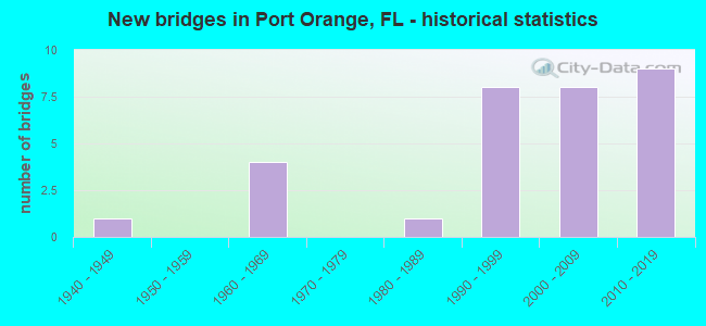
- New bridges - historical statistics
- 11940-1949
- 41960-1969
- 11980-1989
- 81990-1999
- 82000-2009
- 92010-2019
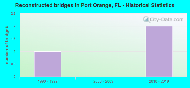
- Reconstructed bridges - Historical Statistics
- 11990-1999
- 02000-2009
- 22010-2019
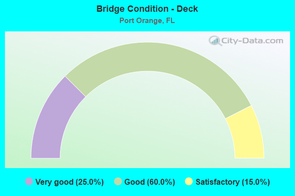
- Bridge Condition - Deck
- 25.0%Very good
- 60.0%Good
- 15.0%Satisfactory
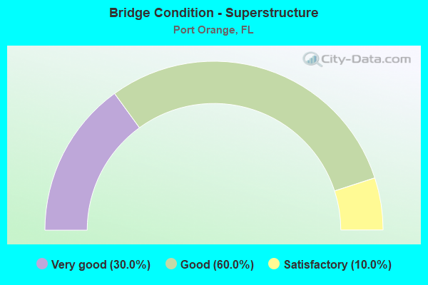
- Bridge Condition - Superstructure
- 30.0%Very good
- 60.0%Good
- 10.0%Satisfactory
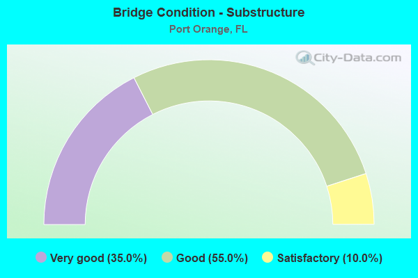
- Bridge Condition - Substructure
- 35.0%Very good
- 55.0%Good
- 10.0%Satisfactory
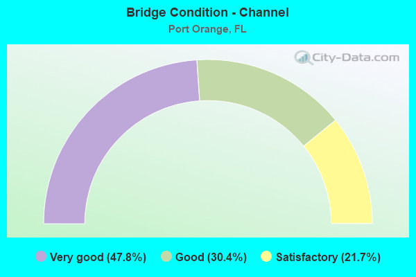
- Bridge Condition - Channel
- 47.8%Very good
- 30.4%Good
- 21.7%Satisfactory
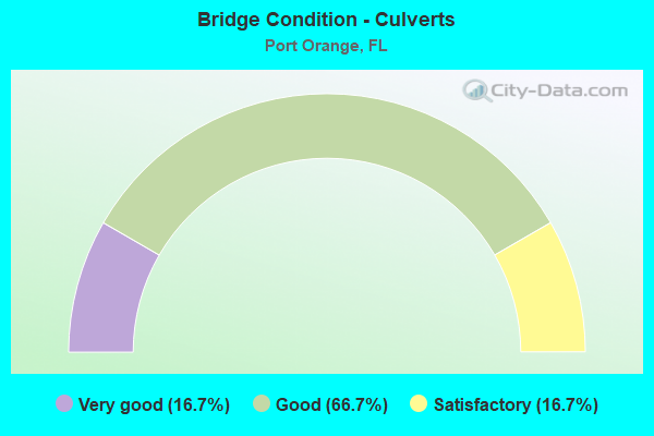
- Bridge Condition - Culverts
- 16.7%Very good
- 66.7%Good
- 16.7%Satisfactory
Find on map >> Show street view
Structure Number: 790136, Location: 400ft N of SCLRR on SR-5A (Lat: 29.115658, Lng: -80.987658), Route carried "on" structure: State highway 5A, Year Built: 1948, Year Reconstructed: 2003, Status: Open, Structure Length: 0.61m (2.00ft), Average Daily Traffic: 20,500 (year 2020), Truck Traffic: 6%, Average Future Daily Traffic: 35,568 (year 2042), Design Load: H 15, Features Intersected: Halifax Canal
Minimum Vertical Clearance: 30+ m (98+ ft), Kilometerpoint: 1.717, Lanes on structure: 5, Base Highway Network: Yes, Owner: State Highway Agency, Approaching Roadway Width: 17.1m (56.1ft), Skew: 22 degrees, Material/Design: Concrete, Design/Construction: Culvert, Number Of Spans In Main Unit: 2, Length of Maximum Span: 3.0m (9.8ft), Curb or Sidewalk Widths: Left: 2.1m (6.9ft), Right: 2.3m (7.5ft)
Condition: Channel: Very good, Culverts: Good, Operating Rating: 76.3 metric tons, Method Used To Determine Operating Rating: Load Factor (LF), Inventory Rating: 45.8 metric tons, Method Used To Determine Inventory Rating: Load Factor (LF), Structural Evaluation: Better than present minimum criteria, Waterway Adequacy: Equal to present desirable criteria, Approach Roadway Alignment: Equal to present desirable criteria, Designated Inspection Frequency: Every 24 months, Inspection Date: May 2021
Find on map >> Show street view
Structure Number: 790147, Location: A1A-Port Orange Relief (Lat: 29.144344, Lng: -80.983981), Route carried "on" structure: State highway A1A, Year Built: 1990, Status: Open, Structure Length: 22.92m (75.20ft), Average Daily Traffic: 24,500 (year 2020), Truck Traffic: 4%, Average Future Daily Traffic: 42,508 (year 2042), Design Load: HS 20, Features Intersected: Halifax River
Minimum Vertical Clearance: 30+ m (98+ ft), Kilometerpoint: 0.237, Lanes on structure: 4, Owner: State Highway Agency, Approaching Roadway Width: 17.9m (58.7ft), Skew: 20 degrees, Material/Design: Concrete continuous, Design/Construction: Slab, Number Of Spans In Main Unit: 27, Length of Maximum Span: 8.5m (27.9ft), Curb or Sidewalk Widths: Left: 1.5m (4.9ft), Right: 1.5m (4.9ft), Curb-To-Curb Width: 20.3m (66.6ft), Out-to-Out Width: 29.9m (98.1ft)
Condition: Deck: Satisfactory, Superstructure: Satisfactory, Substructure: Satisfactory, Channel: Very good, Operating Rating: 51.7 metric tons, Method Used To Determine Operating Rating: Load Factor (LF), Inventory Rating: 31.0 metric tons, Method Used To Determine Inventory Rating: Load Factor (LF), Structural Evaluation: Equal to present minimum criteria, Deck Geometry: Equal to present desirable criteria, Waterway Adequacy: Superior to present desirable criteria, Approach Roadway Alignment: Equal to present desirable criteria, Length Of Structure Improvement: 22.86m (75.00ft), Designated Inspection Frequency: Every 24 months, Underwater Inspection Frequency: Every 24 months, Inspection Date: October 2021, Underwater Inspection Date: November 2021, Bridge Improvement Cost: $70,000, Total Project Cost: $159,000, Deck Structure Type: Concrete Cast-file-Place, Wearing Surface/Protective System: Wearing Surface: Monolithic Concrete, Deck Protection: Bituminous
Find on map >> Show street view
Structure Number: 790148, Location: SR-A1A over Halifax River (Lat: 29.148261, Lng: -80.975478), Route carried "on" structure: Alternate State highway A1A, Year Built: 1990, Status: Open, Structure Length: 61.02m (200.20ft), Average Daily Traffic: 24,500 (year 2020), Truck Traffic: 4%, Average Future Daily Traffic: 42,508 (year 2042), Design Load: HS 20, Features Intersected: IWW Halifax River
Minimum Vertical Clearance: 30+ m (98+ ft), Kilometerpoint: 0.978, Lanes on structure: 4, Lanes under structure: 4, Base Highway Network: Yes, Owner: State Highway Agency, Approaching Roadway Width: 23.8m (78.1ft), Skew: 30 degrees, Navigation Control: Yes ( Vertical Clearance: 19.8m (65.0ft), Horizontal Clearance: 27.0m (88.6ft)), Material/Design: Steel continuous, Design/Construction: Stringer/Multi-beam, Number Of Spans In Main Unit: 3, Number Of Approach Spans: 11, Length of Maximum Span: 64.0m (210.0ft), Curb or Sidewalk Widths: Left: 1.5m (4.9ft), Right: 0.0m, Curb-To-Curb Width: 23.8m (78.1ft), Out-to-Out Width: 27.6m (90.6ft)
Condition: Deck: Satisfactory, Superstructure: Good, Substructure: Satisfactory, Channel: Very good, Operating Rating: 55.1 metric tons, Method Used To Determine Operating Rating: Load Factor (LF), Inventory Rating: 33.1 metric tons, Method Used To Determine Inventory Rating: Load Factor (LF), Structural Evaluation: Equal to present minimum criteria, Deck Geometry: Superior to present desirable criteria, Underclear: High priority of corrective action, Waterway Adequacy: Superior to present desirable criteria, Approach Roadway Alignment: Equal to present desirable criteria, Length Of Structure Improvement: 60.96m (200.00ft), Designated Inspection Frequency: Every 24 months, Underwater Inspection Frequency: Every 24 months, Inspection Date: June 2021, Underwater Inspection Date: July 2021, Bridge Improvement Cost: $265,000, Total Project Cost: $331,000, Deck Structure Type: Concrete Cast-file-Place, Wearing Surface/Protective System: Wearing Surface: Monolithic Concrete, Membrane: Epoxy
Find on map >> Show street view
Structure Number: 790155, Location: US-1 SB - Spruce Creek (Lat: 29.086339, Lng: -80.968700), Route carried "on" structure: US 1, Year Built: 2000, Status: Open, Structure Length: 11.03m (36.19ft), Average Daily Traffic: 11,750 (year 2020), Truck Traffic: 6%, Average Future Daily Traffic: 20,386 (year 2042), Design Load: HS 20, Features Intersected: Spruce Creek
Minimum Vertical Clearance: 30+ m (98+ ft), Kilometerpoint: 37.643, Lanes on structure: 2, Base Highway Network: Yes, Owner: State Highway Agency, Approaching Roadway Width: 11.0m (36.1ft), Material/Design: Concrete continuous, Design/Construction: Slab, Number Of Spans In Main Unit: 13, Length of Maximum Span: 9.1m (29.9ft), Curb-To-Curb Width: 12.2m (40.0ft), Out-to-Out Width: 13.1m (43.0ft)
Condition: Deck: Good, Superstructure: Good, Substructure: Good, Channel: Very good, Operating Rating: 62.7 metric tons, Method Used To Determine Operating Rating: Load Factor (LF), Inventory Rating: 37.6 metric tons, Method Used To Determine Inventory Rating: Load Factor (LF), Structural Evaluation: Better than present minimum criteria, Deck Geometry: Better than present minimum criteria, Waterway Adequacy: Equal to present desirable criteria, Approach Roadway Alignment: Equal to present desirable criteria, Designated Inspection Frequency: Every 24 months, Underwater Inspection Frequency: Every 24 months, Inspection Date: December 2021, Underwater Inspection Date: January 2022, Deck Structure Type: Concrete Cast-file-Place, Wearing Surface/Protective System: Deck Protection: Bituminous
Find on map >> Show street view
Structure Number: 790157, Location: US-1SB - Spruce Cr. S. (Lat: 29.083894, Lng: -80.967119), Route carried "on" structure: US 1, Year Built: 2000, Status: Open, Structure Length: 8.54m (28.02ft), Average Daily Traffic: 11,750 (year 2020), Truck Traffic: 6%, Average Future Daily Traffic: 20,386 (year 2042), Design Load: HS 20, Features Intersected: Spruce Creek S. Relief
Minimum Vertical Clearance: 30+ m (98+ ft), Kilometerpoint: 37.348, Lanes on structure: 2, Base Highway Network: Yes, Owner: State Highway Agency, Approaching Roadway Width: 12.2m (40.0ft), Material/Design: Concrete continuous, Design/Construction: Slab, Number Of Spans In Main Unit: 9, Length of Maximum Span: 9.1m (29.9ft), Curb-To-Curb Width: 12.2m (40.0ft), Out-to-Out Width: 13.0m (42.7ft)
Condition: Deck: Good, Superstructure: Good, Substructure: Good, Channel: Good, Operating Rating: 66.3 metric tons, Method Used To Determine Operating Rating: Load Factor (LF), Inventory Rating: 39.8 metric tons, Method Used To Determine Inventory Rating: Load Factor (LF), Structural Evaluation: Better than present minimum criteria, Deck Geometry: Better than present minimum criteria, Waterway Adequacy: Equal to present desirable criteria, Approach Roadway Alignment: Equal to present desirable criteria, Designated Inspection Frequency: Every 24 months, Underwater Inspection Frequency: Every 24 months, Inspection Date: December 2021, Underwater Inspection Date: January 2022, Deck Structure Type: Concrete Cast-file-Place, Wearing Surface/Protective System: Wearing Surface: Monolithic Concrete, Deck Protection: Bituminous
Find on map >> Show street view
Structure Number: 790158, Location: US-1 NB - Spruce Cr. S. (Lat: 29.084028, Lng: -80.967139), Route carried "on" structure: US 1, Year Built: 2001, Status: Open, Structure Length: 8.54m (28.02ft), Average Daily Traffic: 11,750 (year 2020), Truck Traffic: 6%, Average Future Daily Traffic: 20,386 (year 2042), Design Load: HS 20, Features Intersected: Spruce Creek S. Relief
Minimum Vertical Clearance: 30+ m (98+ ft), Kilometerpoint: 37.348, Lanes on structure: 2, Base Highway Network: Yes, Owner: State Highway Agency, Approaching Roadway Width: 12.2m (40.0ft), Material/Design: Concrete continuous, Design/Construction: Slab, Number Of Spans In Main Unit: 9, Length of Maximum Span: 9.1m (29.9ft), Curb-To-Curb Width: 12.2m (40.0ft), Out-to-Out Width: 13.0m (42.7ft)
Condition: Deck: Good, Superstructure: Good, Substructure: Good, Channel: Good, Operating Rating: 66.3 metric tons, Method Used To Determine Operating Rating: Load Factor (LF), Inventory Rating: 39.8 metric tons, Method Used To Determine Inventory Rating: Load Factor (LF), Structural Evaluation: Better than present minimum criteria, Deck Geometry: Better than present minimum criteria, Waterway Adequacy: Equal to present desirable criteria, Approach Roadway Alignment: Equal to present desirable criteria, Designated Inspection Frequency: Every 24 months, Underwater Inspection Frequency: Every 24 months, Inspection Date: December 2021, Underwater Inspection Date: January 2022, Deck Structure Type: Concrete Cast-file-Place, Wearing Surface/Protective System: Wearing Surface: Monolithic Concrete, Deck Protection: Bituminous
Find on map >> Show street view
Structure Number: 790159, Location: US-1 SB-Spruce Creek (Lat: 29.088619, Lng: -80.970008), Route carried "on" structure: US 1, Year Built: 2000, Status: Open, Structure Length: 6.52m (21.39ft), Average Daily Traffic: 11,750 (year 2020), Truck Traffic: 6%, Average Future Daily Traffic: 20,386 (year 2042), Design Load: HS 20, Features Intersected: Spruce Creek N Relief
Minimum Vertical Clearance: 30+ m (98+ ft), Kilometerpoint: 37.947, Lanes on structure: 2, Base Highway Network: Yes, Owner: State Highway Agency, Approaching Roadway Width: 11.0m (36.1ft), Material/Design: Concrete continuous, Design/Construction: Slab, Number Of Spans In Main Unit: 7, Length of Maximum Span: 9.1m (29.9ft), Curb-To-Curb Width: 12.2m (40.0ft), Out-to-Out Width: 13.1m (43.0ft)
Condition: Deck: Good, Superstructure: Good, Substructure: Good, Channel: Satisfactory, Operating Rating: 66.4 metric tons, Method Used To Determine Operating Rating: Load Factor (LF), Inventory Rating: 39.8 metric tons, Method Used To Determine Inventory Rating: Load Factor (LF), Structural Evaluation: Better than present minimum criteria, Deck Geometry: Better than present minimum criteria, Waterway Adequacy: Equal to present desirable criteria, Approach Roadway Alignment: Equal to present desirable criteria, Designated Inspection Frequency: Every 24 months, Underwater Inspection Frequency: Every 24 months, Inspection Date: December 2021, Underwater Inspection Date: January 2022, Deck Structure Type: Concrete Cast-file-Place, Wearing Surface/Protective System: Wearing Surface: Monolithic Concrete, Deck Protection: Bituminous
Find on map >> Show street view
Structure Number: 79016, Location: US-1 NB - Spruce Creek (Lat: 29.088697, Lng: -80.969739), Route carried "on" structure: US 1, Year Built: 2001, Status: Open, Structure Length: 6.52m (21.39ft), Average Daily Traffic: 11,750 (year 2020), Truck Traffic: 6%, Average Future Daily Traffic: 20,386 (year 2042), Design Load: HS 20, Features Intersected: Spruce Creek N. Relief
Minimum Vertical Clearance: 30+ m (98+ ft), Kilometerpoint: 37.947, Lanes on structure: 2, Base Highway Network: Yes, Owner: State Highway Agency, Approaching Roadway Width: 11.0m (36.1ft), Material/Design: Concrete continuous, Design/Construction: Slab, Number Of Spans In Main Unit: 7, Length of Maximum Span: 9.1m (29.9ft), Curb-To-Curb Width: 12.2m (40.0ft), Out-to-Out Width: 13.0m (42.7ft)
Condition: Deck: Good, Superstructure: Good, Substructure: Good, Channel: Good, Operating Rating: 66.4 metric tons, Method Used To Determine Operating Rating: Load Factor (LF), Inventory Rating: 39.8 metric tons, Method Used To Determine Inventory Rating: Load Factor (LF), Structural Evaluation: Better than present minimum criteria, Deck Geometry: Better than present minimum criteria, Waterway Adequacy: Equal to present desirable criteria, Approach Roadway Alignment: Equal to present desirable criteria, Designated Inspection Frequency: Every 24 months, Underwater Inspection Frequency: Every 24 months, Inspection Date: December 2021, Underwater Inspection Date: January 2022, Deck Structure Type: Concrete Cast-file-Place, Wearing Surface/Protective System: Wearing Surface: Monolithic Concrete, Deck Protection: Bituminous
Find on map >> Show street view
Structure Number: 790161, Location: US-1 SB over Rose Bay (Lat: 29.103619, Lng: -80.972031), Route carried "on" structure: US 1, Year Built: 2001, Status: Open, Structure Length: 22.71m (74.51ft), Average Daily Traffic: 11,750 (year 2020), Truck Traffic: 6%, Average Future Daily Traffic: 20,386 (year 2042), Design Load: HS 25 or greater, Features Intersected: Rose Bay
Minimum Vertical Clearance: 30+ m (98+ ft), Kilometerpoint: 39.551, Lanes on structure: 2, Base Highway Network: Yes, Owner: State Highway Agency, Approaching Roadway Width: 9.8m (32.2ft), Skew: 10 degrees, Material/Design: Concrete continuous, Design/Construction: Slab, Number Of Spans In Main Unit: 25, Length of Maximum Span: 9.1m (29.9ft), Curb-To-Curb Width: 12.2m (40.0ft), Out-to-Out Width: 13.1m (43.0ft)
Condition: Deck: Good, Superstructure: Good, Substructure: Good, Channel: Very good, Operating Rating: 71.1 metric tons, Method Used To Determine Operating Rating: Load Factor (LF), Inventory Rating: 42.7 metric tons, Method Used To Determine Inventory Rating: Load Factor (LF), Structural Evaluation: Better than present minimum criteria, Deck Geometry: Better than present minimum criteria, Waterway Adequacy: Equal to present minimum criteria, Approach Roadway Alignment: Equal to present desirable criteria, Designated Inspection Frequency: Every 24 months, Underwater Inspection Frequency: Every 24 months, Inspection Date: Febuary 2022, Underwater Inspection Date: March 2020, Deck Structure Type: Concrete Cast-file-Place, Wearing Surface/Protective System: Wearing Surface: Monolithic Concrete, Deck Protection: Bituminous
Find on map >> Show street view
Structure Number: 790162, Location: US-1 NB over Rose Bay (Lat: 29.103683, Lng: -80.971764), Route carried "on" structure: US 1, Year Built: 2001, Status: Open, Structure Length: 22.71m (74.51ft), Average Daily Traffic: 11,750 (year 2020), Truck Traffic: 6%, Average Future Daily Traffic: 20,386 (year 2042), Design Load: HS 25 or greater, Features Intersected: Rose Bay
Minimum Vertical Clearance: 30+ m (98+ ft), Kilometerpoint: 39.551, Lanes on structure: 2, Base Highway Network: Yes, Owner: State Highway Agency, Approaching Roadway Width: 9.6m (31.5ft), Material/Design: Concrete continuous, Design/Construction: Slab, Number Of Spans In Main Unit: 25, Length of Maximum Span: 9.1m (29.9ft), Curb-To-Curb Width: 12.2m (40.0ft), Out-to-Out Width: 13.1m (43.0ft)
Condition: Deck: Good, Superstructure: Good, Substructure: Good, Channel: Very good, Operating Rating: 71.2 metric tons, Method Used To Determine Operating Rating: Load Factor (LF), Inventory Rating: 42.7 metric tons, Method Used To Determine Inventory Rating: Load Factor (LF), Structural Evaluation: Better than present minimum criteria, Deck Geometry: Better than present minimum criteria, Waterway Adequacy: Equal to present minimum criteria, Approach Roadway Alignment: Equal to present desirable criteria, Designated Inspection Frequency: Every 24 months, Underwater Inspection Frequency: Every 24 months, Inspection Date: Febuary 2022, Underwater Inspection Date: March 2020, Deck Structure Type: Concrete Cast-file-Place, Wearing Surface/Protective System: Wearing Surface: Monolithic Concrete, Deck Protection: Bituminous
Find on map >> Show street view
Structure Number: 790173, Location: 0.75 mi. E. of I-95 (Lat: 29.113558, Lng: -81.024989), Route carried "on" structure: State highway 421, Year Built: 1995, Status: Open, Structure Length: 1.28m (4.20ft), Average Daily Traffic: 26,000 (year 2020), Truck Traffic: 4%, Average Future Daily Traffic: 45,110 (year 2042), Design Load: HS 20, Features Intersected: Sweetwater Creek
Minimum Vertical Clearance: 30+ m (98+ ft), Kilometerpoint: 1.289, Lanes on structure: 6, Owner: State Highway Agency, Approaching Roadway Width: 24.8m (81.4ft), Skew: 25 degrees, Material/Design: Concrete, Design/Construction: Culvert, Number Of Spans In Main Unit: 2, Length of Maximum Span: 5.2m (17.1ft)
Condition: Channel: Satisfactory, Culverts: Satisfactory, Operating Rating: 56.2 metric tons, Method Used To Determine Operating Rating: Load Factor (LF), Inventory Rating: 33.7 metric tons, Method Used To Determine Inventory Rating: Load Factor (LF), Structural Evaluation: Equal to present minimum criteria, Waterway Adequacy: Equal to present desirable criteria, Approach Roadway Alignment: Equal to present desirable criteria, Designated Inspection Frequency: Every 24 months, Inspection Date: March 2021
Find on map >> Show street view
Structure Number: 790226, Location: I95 SB 1 Mi S of SR-421 (Lat: 29.090756, Lng: -81.021239), Route carried "on" structure: Interstate 95, Year Built: 2017, Status: Open, Structure Length: 35.11m (115.19ft), Average Daily Traffic: 21,518 (year 2020), Truck Traffic: 18%, Average Future Daily Traffic: 37,334 (year 2042), Design Load: HL 93, Features Intersected: Spruce Creek
Minimum Vertical Clearance: 30+ m (98+ ft), Kilometerpoint: 35.433, Lanes on structure: 3, Base Highway Network: Yes, Owner: State Highway Agency, Approaching Roadway Width: 17.1m (56.1ft), Material/Design: Prestressed concrete, Design/Construction: Stringer/Multi-beam, Number Of Spans In Main Unit: 12, Length of Maximum Span: 29.3m (96.1ft), Curb-To-Curb Width: 17.1m (56.1ft), Out-to-Out Width: 18.0m (59.1ft)
Condition: Deck: Very good, Superstructure: Very good, Substructure: Very good, Channel: Very good, Operating Rating: 45.1 metric tons, Method Used To Determine Operating Rating: Load and Resistance Factor (LRFR), Inventory Rating: 34.7 metric tons, Method Used To Determine Inventory Rating: Load and Resistance Factor (LRFR), Structural Evaluation: Equal to present desirable criteria, Deck Geometry: Equal to present minimum criteria, Waterway Adequacy: Equal to present desirable criteria, Approach Roadway Alignment: Equal to present desirable criteria, Designated Inspection Frequency: Every 24 months, Underwater Inspection Frequency: Every 24 months, Inspection Date: March 2021, Underwater Inspection Date: March 2021, Deck Structure Type: Concrete Cast-file-Place
Find on map >> Show street view
Structure Number: 790227, Location: I95 NB 1 Mi S of SR-421 (Lat: 29.090867, Lng: -81.020919), Route carried "on" structure: Interstate 95, Year Built: 2017, Status: Open, Structure Length: 35.11m (115.19ft), Average Daily Traffic: 21,518 (year 2020), Truck Traffic: 18%, Average Future Daily Traffic: 37,334 (year 2042), Design Load: HL 93, Features Intersected: Spruce Creek
Minimum Vertical Clearance: 30+ m (98+ ft), Kilometerpoint: 35.433, Lanes on structure: 3, Base Highway Network: Yes, Owner: State Highway Agency, Approaching Roadway Width: 17.1m (56.1ft), Material/Design: Prestressed concrete, Design/Construction: Stringer/Multi-beam, Number Of Spans In Main Unit: 12, Length of Maximum Span: 29.3m (96.1ft), Curb-To-Curb Width: 17.1m (56.1ft), Out-to-Out Width: 18.0m (59.1ft)
Condition: Deck: Very good, Superstructure: Very good, Substructure: Very good, Channel: Very good, Operating Rating: 44.7 metric tons, Method Used To Determine Operating Rating: Load and Resistance Factor (LRFR), Inventory Rating: 34.7 metric tons, Method Used To Determine Inventory Rating: Load and Resistance Factor (LRFR), Structural Evaluation: Equal to present desirable criteria, Deck Geometry: Equal to present minimum criteria, Waterway Adequacy: Equal to present desirable criteria, Approach Roadway Alignment: Equal to present desirable criteria, Designated Inspection Frequency: Every 24 months, Underwater Inspection Frequency: Every 24 months, Inspection Date: March 2021, Underwater Inspection Date: March 2021, Deck Structure Type: Concrete Cast-file-Place, Wearing Surface/Protective System: Wearing Surface: Monolithic Concrete
Find on map >> Show street view
Structure Number: 790228, Location: I-95 SB 4.5 Mi S of SR400 (Lat: 29.106056, Lng: -81.028889), Route carried "on" structure: Interstate 95, Year Built: 2017, Status: Open, Structure Length: 5.86m (19.23ft), Average Daily Traffic: 37,250 (year 2020), Truck Traffic: 18%, Average Future Daily Traffic: 64,629 (year 2042), Design Load: HL 93, Features Intersected: SR-421
Minimum Vertical Clearance: 30+ m (98+ ft), Kilometerpoint: 37.429, Lanes on structure: 3, Lanes under structure: 8, Base Highway Network: Yes, Owner: State Highway Agency, Approaching Roadway Width: 17.1m (56.1ft), Material/Design: Prestressed concrete, Design/Construction: Stringer/Multi-beam, Number Of Spans In Main Unit: 1, Length of Maximum Span: 58.5m (191.9ft), Curb-To-Curb Width: 17.1m (56.1ft), Out-to-Out Width: 18.0m (59.1ft)
Condition: Deck: Very good, Superstructure: Very good, Substructure: Very good, Operating Rating: 45.1 metric tons, Method Used To Determine Operating Rating: Load and Resistance Factor (LRFR), Inventory Rating: 40.8 metric tons, Method Used To Determine Inventory Rating: Load and Resistance Factor (LRFR), Structural Evaluation: Equal to present desirable criteria, Deck Geometry: Equal to present minimum criteria, Underclear: Meets minimum limits, Approach Roadway Alignment: Equal to present desirable criteria, Designated Inspection Frequency: Every 24 months, Inspection Date: March 2021, Deck Structure Type: Concrete Cast-file-Place
Find on map >> Show street view
Structure Number: 790229, Location: I-95 NB 4.5 Mi S of SR400 (Lat: 29.106111, Lng: -81.028333), Route carried "on" structure: Interstate 95, Year Built: 2017, Status: Open, Structure Length: 5.86m (19.23ft), Average Daily Traffic: 37,250 (year 2020), Truck Traffic: 18%, Average Future Daily Traffic: 64,629 (year 2042), Design Load: HL 93, Features Intersected: SR-421
Minimum Vertical Clearance: 30+ m (98+ ft), Kilometerpoint: 37.429, Lanes on structure: 3, Lanes under structure: 8, Base Highway Network: Yes, Owner: State Highway Agency, Approaching Roadway Width: 17.1m (56.1ft), Material/Design: Prestressed concrete, Design/Construction: Stringer/Multi-beam, Number Of Spans In Main Unit: 1, Length of Maximum Span: 58.6m (192.3ft), Curb-To-Curb Width: 17.1m (56.1ft), Out-to-Out Width: 18.0m (59.1ft)
Condition: Deck: Very good, Superstructure: Very good, Substructure: Very good, Operating Rating: 45.1 metric tons, Method Used To Determine Operating Rating: Load and Resistance Factor (LRFR), Inventory Rating: 40.8 metric tons, Method Used To Determine Inventory Rating: Load and Resistance Factor (LRFR), Structural Evaluation: Equal to present desirable criteria, Deck Geometry: Equal to present minimum criteria, Underclear: Meets minimum limits, Approach Roadway Alignment: Equal to present desirable criteria, Designated Inspection Frequency: Every 24 months, Inspection Date: March 2021, Deck Structure Type: Concrete Cast-file-Place
Find on map >> Show street view
Structure Number: 790245, Location: 0.2mi. S of Williamson Rd (Lat: 29.120683, Lng: -81.045675), Route carried "on" structure: Interstate 95, Year Built: 1969, Year Reconstructed: 2018, Status: Open, Structure Length: 0.76m (2.49ft), Average Daily Traffic: 37,250 (year 2020), Truck Traffic: 18%, Average Future Daily Traffic: 64,629 (year 2042), Design Load: HS 20, Features Intersected: Timothy's Ditch
Minimum Vertical Clearance: 30+ m (98+ ft), Kilometerpoint: 39.802, Lanes on structure: 3, Base Highway Network: Yes, Owner: State Highway Agency, Approaching Roadway Width: 13.7m (44.9ft), Skew: 11 degrees, Material/Design: Concrete, Design/Construction: Culvert, Number Of Spans In Main Unit: 2, Length of Maximum Span: 3.7m (12.1ft)
Condition: Channel: Satisfactory, Culverts: Good, Operating Rating: 84.5 metric tons, Method Used To Determine Operating Rating: Load Factor (LF), Inventory Rating: 50.6 metric tons, Method Used To Determine Inventory Rating: Load Factor (LF), Structural Evaluation: Better than present minimum criteria, Waterway Adequacy: Equal to present desirable criteria, Approach Roadway Alignment: Equal to present desirable criteria, Designated Inspection Frequency: Every 24 months, Inspection Date: January 2022
Find on map >> Show street view
Structure Number: 790246, Location: 0.2mi. S of Williamson Rd (Lat: 29.120831, Lng: -81.045000), Route carried "on" structure: Interstate 95, Year Built: 1969, Year Reconstructed: 2018, Status: Open, Structure Length: 0.76m (2.49ft), Average Daily Traffic: 37,250 (year 2020), Truck Traffic: 18%, Average Future Daily Traffic: 64,629 (year 2042), Design Load: HS 20, Features Intersected: Timothy's Ditch
Minimum Vertical Clearance: 30+ m (98+ ft), Kilometerpoint: 39.788, Lanes on structure: 3, Base Highway Network: Yes, Owner: State Highway Agency, Approaching Roadway Width: 13.7m (44.9ft), Skew: 1 degrees, Material/Design: Concrete, Design/Construction: Culvert, Number Of Spans In Main Unit: 2, Length of Maximum Span: 3.7m (12.1ft)
Condition: Channel: Satisfactory, Culverts: Good, Operating Rating: 84.5 metric tons, Method Used To Determine Operating Rating: Load Factor (LF), Inventory Rating: 50.6 metric tons, Method Used To Determine Inventory Rating: Load Factor (LF), Structural Evaluation: Better than present minimum criteria, Waterway Adequacy: Better than present minimum criteria, Approach Roadway Alignment: Equal to present desirable criteria, Designated Inspection Frequency: Every 24 months, Inspection Date: January 2022
Find on map >> Show street view
Structure Number: 79401, Location: 0.2 Mi. East of SR-421 (Lat: 29.106889, Lng: -81.023111), Route carried "on" structure: County highway , Year Built: 1962, Status: Open, Structure Length: 0.76m (2.49ft), Average Daily Traffic: 20,000 (year 2020), Truck Traffic: 2%, Average Future Daily Traffic: 34,700 (year 2042), Design Load: HS 20, Features Intersected: Sweetwater Branch, Facility Carried by Structure: Taylor Rd
Minimum Vertical Clearance: 30+ m (98+ ft), Kilometerpoint: 0.414, Lanes on structure: 2, Owner: County Highway Agency, Approaching Roadway Width: 7.9m (25.9ft), Material/Design: Prestressed concrete, Design/Construction: Channel Beam, Number Of Spans In Main Unit: 1, Length of Maximum Span: 7.6m (24.9ft), Curb or Sidewalk Widths: Left: 0.4m (1.3ft), Right: 0.4m (1.3ft), Curb-To-Curb Width: 8.0m (26.2ft), Out-to-Out Width: 9.1m (29.9ft)
Condition: Deck: Good, Superstructure: Good, Substructure: Good, Channel: Good, Operating Rating: 55.1 metric tons, Method Used To Determine Operating Rating: Load Factor (LF), Inventory Rating: 33.0 metric tons, Method Used To Determine Inventory Rating: Load Factor (LF), Structural Evaluation: Better than present minimum criteria, Deck Geometry: High priority of replacement, Waterway Adequacy: Equal to present desirable criteria, Approach Roadway Alignment: Equal to present desirable criteria, Designated Inspection Frequency: Every 24 months, Inspection Date: April 2020, Deck Structure Type: Other, Wearing Surface/Protective System: Wearing Surface: Bituminous
Find on map >> Show street view
Structure Number: 794095, Location: S. Williamson BI-I-95 (Lat: 29.122347, Lng: -81.047847), Route carried "on" structure: County highway 4009, Year Built: 1994, Status: Open, Structure Length: 9.12m (29.92ft), Average Daily Traffic: 18,800 (year 2018), Truck Traffic: 11%, Average Future Daily Traffic: 32,618 (year 2040), Design Load: HS 20, Features Intersected: I-95, Facility Carried by Structure: S Williamson Blvd
Minimum Vertical Clearance: 30+ m (98+ ft), Kilometerpoint: 2.652, Lanes on structure: 2, Lanes under structure: 6, Base Highway Network: Yes, Owner: County Highway Agency, Approaching Roadway Width: 12.3m (40.4ft), Skew: 2 degrees, Material/Design: Prestressed concrete, Design/Construction: Stringer/Multi-beam, Number Of Spans In Main Unit: 3, Length of Maximum Span: 37.3m (122.4ft), Curb-To-Curb Width: 12.8m (42.0ft), Out-to-Out Width: 13.7m (44.9ft)
Condition: Deck: Good, Superstructure: Good, Substructure: Good, Operating Rating: 76.9 metric tons, Method Used To Determine Operating Rating: Load Factor (LF), Inventory Rating: 46.2 metric tons, Method Used To Determine Inventory Rating: Load Factor (LF), Structural Evaluation: Better than present minimum criteria, Deck Geometry: Somewhat better than minimum adequacy, Underclear: Superior to present desirable criteria, Approach Roadway Alignment: Equal to present desirable criteria, Designated Inspection Frequency: Every 24 months, Inspection Date: March 2020, Deck Structure Type: Concrete Cast-file-Place
Find on map >> Show street view
Structure Number: 794122, Location: 0.2 mile East of US-1 (Lat: 29.109186, Lng: -80.971406), Route carried "on" structure: County highway , Year Built: 1988, Status: Open, Structure Length: 1.89m (6.20ft), Average Daily Traffic: 800 (year 2020), Truck Traffic: 4%, Average Future Daily Traffic: 1,388 (year 2042), Design Load: HS 20, Features Intersected: Rose Bay Canal, Facility Carried by Structure: Main Street
Minimum Vertical Clearance: 30+ m (98+ ft), Kilometerpoint: 0.171, Lanes on structure: 2, Owner: City or Municipal Highway Agency, Approaching Roadway Width: 6.1m (20.0ft), Skew: 1 degrees, Material/Design: Concrete continuous, Design/Construction: Slab, Number Of Spans In Main Unit: 2, Length of Maximum Span: 9.4m (30.8ft), Curb-To-Curb Width: 9.8m (32.2ft), Out-to-Out Width: 10.6m (34.8ft)
Condition: Deck: Good, Superstructure: Good, Substructure: Good, Channel: Satisfactory, Operating Rating: 80.7 metric tons, Method Used To Determine Operating Rating: Load Factor (LF), Inventory Rating: 48.1 metric tons, Method Used To Determine Inventory Rating: Load Factor (LF), Structural Evaluation: Better than present minimum criteria, Deck Geometry: Equal to present minimum criteria, Waterway Adequacy: Equal to present desirable criteria, Approach Roadway Alignment: Equal to present desirable criteria, Designated Inspection Frequency: Every 24 months, Underwater Inspection Frequency: Every 24 months, Inspection Date: May 2020, Underwater Inspection Date: May 2020, Deck Structure Type: Concrete Cast-file-Place
Find on map >> Show street view
Structure Number: 794188, Location: 0.6 Mi E of Williamson Bv (Lat: 29.141583, Lng: -81.045000), Route carried "on" structure: City street , Year Built: 2000, Status: Open, Structure Length: 1.28m (4.20ft), Average Daily Traffic: 2,500 (year 2018), Truck Traffic: 5%, Average Future Daily Traffic: 4,338 (year 2038), Design Load: HS 20, Features Intersected: B19 Canal, Facility Carried by Structure: Madeline Avenue
Minimum Vertical Clearance: 30+ m (98+ ft), Kilometerpoint: 0.948, Lanes on structure: 3, Owner: County Highway Agency, Approaching Roadway Width: 10.2m (33.5ft), Material/Design: Concrete, Design/Construction: Culvert, Number Of Spans In Main Unit: 1, Length of Maximum Span: 12.8m (42.0ft)
Condition: Channel: Good, Culverts: Good, Inventory Rating: 57.9 metric tons, Method Used To Determine Inventory Rating: Load Factor (LF), Structural Evaluation: Better than present minimum criteria, Waterway Adequacy: Somewhat better than minimum adequacy, Approach Roadway Alignment: Equal to present desirable criteria, Designated Inspection Frequency: Every 24 months, Inspection Date: June 2021
Find on map >> Show street view
Structure Number: 794193, Location: 1 Mi So. of SR-421 (Lat: 29.090722, Lng: -81.026917), Route carried "on" structure: Bypass County highway , Year Built: 2010, Status: Open, Structure Length: 4.88m (16.01ft), Average Daily Traffic: 24,500 (year 2021), Truck Traffic: 10%, Average Future Daily Traffic: 42,508 (year 2042), Design Load: HL 93, Features Intersected: Spruce Creek, Facility Carried by Structure: CR-4009
Minimum Vertical Clearance: 30.45m (99.90ft), Kilometerpoint: 5.704, Lanes on structure: 4, Base Highway Network: Yes, Owner: County Highway Agency, Approaching Roadway Width: 24.0m (78.7ft), Skew: 20 degrees, Material/Design: Concrete continuous, Design/Construction: Slab, Number Of Spans In Main Unit: 4, Length of Maximum Span: 12.2m (40.0ft), Curb or Sidewalk Widths: Left: 2.4m (7.9ft), Right: 1.5m (4.9ft), Curb-To-Curb Width: 24.0m (78.7ft), Out-to-Out Width: 29.4m (96.5ft)
Condition: Deck: Very good, Superstructure: Very good, Substructure: Very good, Channel: Good, Operating Rating: 50.6 metric tons, Method Used To Determine Operating Rating: Load and Resistance Factor (LRFR), Inventory Rating: 38.8 metric tons, Method Used To Determine Inventory Rating: Load and Resistance Factor (LRFR), Structural Evaluation: Equal to present desirable criteria, Deck Geometry: Superior to present desirable criteria, Waterway Adequacy: Equal to present desirable criteria, Approach Roadway Alignment: Equal to present desirable criteria, Designated Inspection Frequency: Every 24 months, Underwater Inspection Frequency: Every 24 months, Inspection Date: October 2021, Underwater Inspection Date: October 2021, Deck Structure Type: Concrete Cast-file-Place
Find on map >> Show street view
Structure Number: 796401, Location: 0.25Mi W of Clyd Mrris Bl (Lat: 29.125742, Lng: -81.029497), Route carried "on" structure: City street , Year Built: 1990, Status: Open, Structure Length: 1.28m (4.20ft), Average Daily Traffic: 7,200 (year 2020), Truck Traffic: 5%, Average Future Daily Traffic: 12,492 (year 2042), Design Load: HS 20+Mod, Features Intersected: B-19 Canal, Facility Carried by Structure: Willow Run Blvd.
Minimum Vertical Clearance: 30+ m (98+ ft), Kilometerpoint: 1.677, Lanes on structure: 3, Owner: City or Municipal Highway Agency, Approaching Roadway Width: 16.9m (55.4ft), Material/Design: Concrete, Design/Construction: Culvert, Number Of Spans In Main Unit: 2, Length of Maximum Span: 6.1m (20.0ft)
Condition: Channel: Good, Culverts: Very good, Operating Rating: 81.6 metric tons, Method Used To Determine Operating Rating: Load Factor (LF), Inventory Rating: 49.1 metric tons, Method Used To Determine Inventory Rating: Load Factor (LF), Structural Evaluation: Equal to present desirable criteria, Waterway Adequacy: Superior to present desirable criteria, Approach Roadway Alignment: Equal to present desirable criteria, Designated Inspection Frequency: Every 24 months, Inspection Date: May 2020
Find on map >> Show street view
Structure Number: 796412, Location: Canal View Blvd Intrsectn (Lat: 29.137103, Lng: -81.007917), Route carried "on" structure: City street , Year Built: 1962, Status: Posted for load, Structure Length: 0.76m (2.49ft), Average Daily Traffic: 6,493 (year 2020), Truck Traffic: 5%, Average Future Daily Traffic: 11,266 (year 2042), Design Load: HS 20, Features Intersected: Halifax Canal Lateral, Facility Carried by Structure: Jackson Street
Minimum Vertical Clearance: 30+ m (98+ ft), Kilometerpoint: 0.000, Lanes on structure: 2, Owner: City or Municipal Highway Agency, Approaching Roadway Width: 6.1m (20.0ft), Material/Design: Prestressed concrete, Design/Construction: Channel Beam, Number Of Spans In Main Unit: 1, Length of Maximum Span: 7.6m (24.9ft), Curb or Sidewalk Widths: Left: 0.4m (1.3ft), Right: 0.4m (1.3ft), Curb-To-Curb Width: 7.9m (25.9ft), Out-to-Out Width: 8.8m (28.9ft)
Condition: Deck: Good, Superstructure: Satisfactory, Substructure: Good, Channel: Very good, Operating Rating: 44.8 metric tons, Method Used To Determine Operating Rating: Load Factor (LF), Inventory Rating: 26.9 metric tons, Method Used To Determine Inventory Rating: Load Factor (LF), Structural Evaluation: Equal to present minimum criteria, Deck Geometry: High priority of replacement, Waterway Adequacy: Equal to present minimum criteria, Approach Roadway Alignment: Equal to present desirable criteria, Designated Inspection Frequency: Every 24 months, Inspection Date: May 2020, Deck Structure Type: Concrete Cast-file-Place
Find on map >> Show street view
Structure Number: 796413, Location: 200FT N/O Cap Diville Ave (Lat: 29.119942, Lng: -81.032392), Route carried "on" structure: City street , Year Built: 2010, Status: Open, Structure Length: 3.05m (10.01ft), Average Daily Traffic: 200 (year 2020), Truck Traffic: 5%, Average Future Daily Traffic: 500 (year 2042), Design Load: HS 20, Features Intersected: B-19 Canal / Trib 1, Facility Carried by Structure: Esplanade Avenue
Minimum Vertical Clearance: 30+ m (98+ ft), Kilometerpoint: 0.718, Lanes on structure: 2, Owner: City or Municipal Highway Agency, Approaching Roadway Width: 7.3m (24.0ft), Material/Design: Wood or Timber, Design/Construction: Stringer/Multi-beam, Number Of Spans In Main Unit: 5, Length of Maximum Span: 11.9m (39.0ft), Curb or Sidewalk Widths: Left: 1.5m (4.9ft), Right: 1.5m (4.9ft), Curb-To-Curb Width: 7.3m (24.0ft), Out-to-Out Width: 11.6m (38.1ft)
Condition: Deck: Satisfactory, Superstructure: Good, Substructure: Very good, Channel: Very good, Operating Rating: 26.6 metric tons, Method Used To Determine Operating Rating: Load and Resistance Factor (LRFR), Inventory Rating: 20.5 metric tons, Method Used To Determine Inventory Rating: Load and Resistance Factor (LRFR), Structural Evaluation: Somewhat better than minimum adequacy, Deck Geometry: Somewhat better than minimum adequacy, Waterway Adequacy: Equal to present desirable criteria, Approach Roadway Alignment: Equal to present desirable criteria, Designated Inspection Frequency: Every 24 months, Inspection Date: May 2020, Deck Structure Type: Wood or Timber, Wearing Surface/Protective System: Wearing Surface: Wood or Timber
Find on map >> Show street view
Structure Number: 796414, Location: 0.25Mi S/O Wiltshire Blvd (Lat: 29.100300, Lng: -80.987708), Route carried "on" structure: City street , Year Built: 2013, Status: Open, Structure Length: 1.40m (4.59ft), Average Daily Traffic: 200 (year 2020), Truck Traffic: 5%, Average Future Daily Traffic: 400 (year 2042), Design Load: HS 20, Features Intersected: Cambridge Canal, Facility Carried by Structure: Trailwood Drive
Minimum Vertical Clearance: 30+ m (98+ ft), Kilometerpoint: 0.850, Lanes on structure: 2, Owner: City or Municipal Highway Agency, Approaching Roadway Width: 6.7m (22.0ft), Skew: 3 degrees, Material/Design: Wood or Timber, Design/Construction: Stringer/Multi-beam, Number Of Spans In Main Unit: 3, Length of Maximum Span: 8.0m (26.2ft), Curb-To-Curb Width: 6.7m (22.0ft), Out-to-Out Width: 7.3m (24.0ft)
Condition: Deck: Good, Superstructure: Very good, Substructure: Very good, Channel: Very good, Operating Rating: 30.9 metric tons, Method Used To Determine Operating Rating: Load and Resistance Factor (LRFR), Inventory Rating: 23.9 metric tons, Method Used To Determine Inventory Rating: Load and Resistance Factor (LRFR), Structural Evaluation: Equal to present minimum criteria, Deck Geometry: Meets minimum limits, Waterway Adequacy: Equal to present desirable criteria, Approach Roadway Alignment: Equal to present minimum criteria, Designated Inspection Frequency: Every 24 months, Inspection Date: May 2020, Deck Structure Type: Wood or Timber, Wearing Surface/Protective System: Wearing Surface: Wood or Timber
Find on map >> Show street view
Structure Number: 790148, Location: SR-A1A over Halifax River (Lat: 29.148261, Lng: -80.975478), Route carried "under" structure: ServiceCity street , Year Built: 1990, Structure Length: 0. m, Average Daily Traffic: 50 (year 2005), Truck Traffic: 1%, Features Intersected: IWW Halifax River, Facility Carried by Structure: SR-A1A
Minimum Vertical Clearance: 3.35m (10.99ft), Kilometerpoint: 0.000, Lanes on structure: 4, Lanes under structure: 2, Material/Design: Steel continuous, Design/Construction: Stringer/Multi-beam, Length of Maximum Span: 64.0m (210.0ft)
Find on map >> Show street view
Structure Number: 790148, Location: SR-A1A over Halifax River (Lat: 29.148261, Lng: -80.975478), Route carried "under" structure: Business City street , Year Built: 1990, Structure Length: 0. m, Average Daily Traffic: 50 (year 2000), Truck Traffic: 1%, Features Intersected: IWW Halifax River, Facility Carried by Structure: SR-A1A
Minimum Vertical Clearance: 5.27m (17.29ft), Kilometerpoint: 0.000, Lanes on structure: 4, Lanes under structure: 2, Material/Design: Steel continuous, Design/Construction: Stringer/Multi-beam, Length of Maximum Span: 64.0m (210.0ft)
Find on map >> Show street view
Structure Number: 790228, Location: I-95 SB 4.5 Mi S of SR400 (Lat: 29.106056, Lng: -81.028889), Route carried "under" structure: State highway 421, Year Built: 2017, Structure Length: 0. m, Average Daily Traffic: 52,000 (year 2020), Truck Traffic: 4%, Features Intersected: SR-421, Facility Carried by Structure: I-95 SB
Minimum Vertical Clearance: 5.36m (17.59ft), Kilometerpoint: 0.357, Lanes on structure: 3, Lanes under structure: 8, Material/Design: Prestressed concrete, Design/Construction: Stringer/Multi-beam, Length of Maximum Span: 58.5m (191.9ft)
Find on map >> Show street view
Structure Number: 790229, Location: I-95 NB 4.5 Mi S of SR400 (Lat: 29.106111, Lng: -81.028333), Route carried "under" structure: State highway 421, Year Built: 2017, Structure Length: 0. m, Average Daily Traffic: 52,000 (year 2020), Truck Traffic: 4%, Features Intersected: SR-421, Facility Carried by Structure: I-95 NB
Minimum Vertical Clearance: 5.18m (16.99ft), Kilometerpoint: 0.380, Lanes on structure: 3, Lanes under structure: 8, Material/Design: Prestressed concrete, Design/Construction: Stringer/Multi-beam, Length of Maximum Span: 58.6m (192.3ft)
Find on map >> Show street view
Structure Number: 794095, Location: S. Williamson BI-I-95 (Lat: 29.122347, Lng: -81.047847), Route carried "under" structure: Interstate 95, Year Built: 1994, Structure Length: 0. m, Average Daily Traffic: 66,500 (year 2018), Truck Traffic: 7%, Features Intersected: I-95, Facility Carried by Structure: S Williamson Blvd
Minimum Vertical Clearance: 5.33m (17.49ft), Kilometerpoint: 40.219, Lanes on structure: 2, Lanes under structure: 6, Material/Design: Prestressed concrete, Design/Construction: Stringer/Multi-beam, Length of Maximum Span: 37.3m (122.4ft)