Bridge Statistics for Port Orchard, Washington (WA)
Condition, Traffic, Stress, Structural Evaluation, Project Costs
- National Bridge Inventory (NBI) Statistics
- 10Number of bridges
- 190ft / 57.8mTotal length
- $54,314,000Total costs
- 216,350Total average daily traffic
- 11,911Total average daily truck traffic
- National Bridge Inventory (NBI) Registered Bridges for Port Orchard
- No street view available for this location
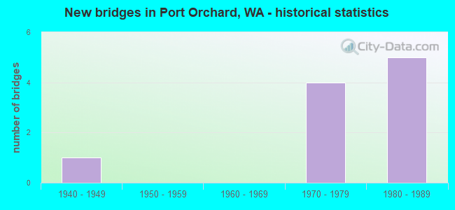
- New bridges - historical statistics
- 11940-1949
- 41970-1979
- 51980-1989

- Bridge Condition - Superstructure
- 85.7%Good
- 14.3%Satisfactory
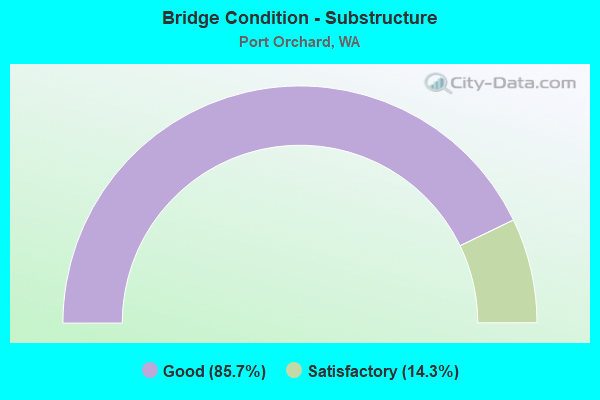
- Bridge Condition - Substructure
- 85.7%Good
- 14.3%Satisfactory
Find on map >> Show street view
Structure Number: 3062A, Location: 4.0 E JCT SR 16 (Lat: 47.533889, Lng: -122.625972), Route carried "on" structure: City street , Year Built: 1945, Status: Open, Structure Length: 4.79m (15.72ft), Average Daily Traffic: 5,187 (year 2002), Truck Traffic: 5%, Average Future Daily Traffic: 9,420 (year 2036), Design Load: HS 15, Features Intersected: SR 166, Facility Carried by Structure: MITCHELL AVE
Minimum Vertical Clearance: 30+ m (98+ ft), Kilometerpoint: 1.416, Lanes on structure: 2, Lanes under structure: 3, Owner: State Highway Agency, Approaching Roadway Width: 7.9m (25.9ft), Material/Design: Concrete, Design/Construction: Tee Beam, Number Of Spans In Main Unit: 3, Length of Maximum Span: 19.8m (65.0ft), Curb or Sidewalk Widths: Left: 1.4m (4.6ft), Right: 1.4m (4.6ft), Curb-To-Curb Width: 7.9m (25.9ft), Out-to-Out Width: 11.5m (37.7ft)
Condition: Deck: Good, Superstructure: Good, Substructure: Good, Operating Rating: 33.7 metric tons, Method Used To Determine Operating Rating: Load and Resistance Factor Rating (LRFR) rating reported by rating factor(RF) method using HL-93 loadings, Inventory Rating: 25.9 metric tons, Method Used To Determine Inventory Rating: Load and Resistance Factor Rating (LRFR) rating reported by rating factor(RF) method using HL-93 loadings, Structural Evaluation: Equal to present minimum criteria, Deck Geometry: High priority of replacement, Underclear: Meets minimum limits, Approach Roadway Alignment: Equal to present desirable criteria, Length Of Structure Improvement: 4.79m (15.72ft), Designated Inspection Frequency: Every 24 months, Inspection Date: July 2021, Bridge Improvement Cost: $879,000, Roadway Improvement Cost: $176,000, Total Project Cost: $1,758,000 ( Estimate for 2014), Deck Structure Type: Concrete Cast-file-Place, Wearing Surface/Protective System: Wearing Surface: Monolithic Concrete
Find on map >> Show street view
Structure Number: 10602A, Location: JCT SR 16 (Lat: 47.500917, Lng: -122.646000), Route carried "on" structure: State highway 160, Year Built: 1977, Status: Open, Structure Length: 6.80m (22.31ft), Average Daily Traffic: 19,311 (year 2019), Truck Traffic: 4%, Average Future Daily Traffic: 25,645 (year 2039), Design Load: HS 20+Mod, Features Intersected: SR 16
Minimum Vertical Clearance: 30+ m (98+ ft), Kilometerpoint: 0.001, Lanes on structure: 3, Lanes under structure: 4, Base Highway Network: Yes, Owner: State Highway Agency, Approaching Roadway Width: 17.7m (58.1ft), Skew: 2 degrees, Material/Design: Prestressed concrete continuous, Design/Construction: Stringer/Multi-beam, Number Of Spans In Main Unit: 2, Length of Maximum Span: 32.6m (107.0ft), Curb-To-Curb Width: 16.8m (55.1ft), Out-to-Out Width: 17.7m (58.1ft)
Condition: Deck: Good, Superstructure: Good, Substructure: Good, Operating Rating: 59.0 metric tons, Method Used To Determine Operating Rating: Load Factor (LF), Inventory Rating: 34.5 metric tons, Method Used To Determine Inventory Rating: Load Factor (LF), Structural Evaluation: Better than present minimum criteria, Deck Geometry: Superior to present desirable criteria, Underclear: Equal to present minimum criteria, Approach Roadway Alignment: Equal to present desirable criteria, Length Of Structure Improvement: 6.80m (22.31ft), Designated Inspection Frequency: Every 24 months, Inspection Date: July 2021, Bridge Improvement Cost: $2,676,000, Roadway Improvement Cost: $535,000, Total Project Cost: $5,352,000 ( Estimate for 2014), Deck Structure Type: Concrete Cast-file-Place, Wearing Surface/Protective System: Wearing Surface: Monolithic Concrete
Find on map >> Show street view
Structure Number: 10602B, Location: 7.6 N PIERCE CO (Lat: 47.511053, Lng: -122.652328), Route carried "on" structure: State highway 16, Year Built: 1977, Status: Open, Structure Length: 9.14m (29.99ft), Average Daily Traffic: 25,625 (year 2019), Truck Traffic: 5%, Average Future Daily Traffic: 34,030 (year 2039), Design Load: HS 20+Mod, Features Intersected: SIDNEY ROAD
Minimum Vertical Clearance: 30+ m (98+ ft), Kilometerpoint: 41.698, Lanes on structure: 2, Lanes under structure: 2, Base Highway Network: Yes, Owner: State Highway Agency, Approaching Roadway Width: 11.6m (38.1ft), Skew: 5 degrees, Material/Design: Prestressed concrete continuous, Design/Construction: Stringer/Multi-beam, Number Of Spans In Main Unit: 3, Length of Maximum Span: 36.9m (121.1ft), Curb-To-Curb Width: 11.6m (38.1ft), Out-to-Out Width: 12.5m (41.0ft)
Condition: Deck: Good, Superstructure: Good, Substructure: Good, Operating Rating: 82.5 metric tons, Method Used To Determine Operating Rating: Load Factor (LF), Inventory Rating: 49.0 metric tons, Method Used To Determine Inventory Rating: Load Factor (LF), Structural Evaluation: Better than present minimum criteria, Deck Geometry: Equal to present minimum criteria, Underclear: Superior to present desirable criteria, Approach Roadway Alignment: Equal to present desirable criteria, Length Of Structure Improvement: 9.14m (29.99ft), Designated Inspection Frequency: Every 24 months, Inspection Date: August 2021, Bridge Improvement Cost: $2,400,000, Roadway Improvement Cost: $480,000, Total Project Cost: $4,800,000 ( Estimate for 2014), Deck Structure Type: Concrete Cast-file-Place, Wearing Surface/Protective System: Wearing Surface: Monolithic Concrete
Find on map >> Show street view
Structure Number: 10602C, Location: 7.6 N PIERCE CO (Lat: 47.511083, Lng: -122.652306), Route carried "on" structure: State highway 16, Year Built: 1977, Status: Open, Structure Length: 9.14m (29.99ft), Average Daily Traffic: 25,625 (year 2019), Truck Traffic: 5%, Average Future Daily Traffic: 34,030 (year 2039), Design Load: HS 20+Mod, Features Intersected: SIDNEY ROAD
Minimum Vertical Clearance: 30+ m (98+ ft), Kilometerpoint: 41.666, Lanes on structure: 2, Lanes under structure: 2, Base Highway Network: Yes, Owner: State Highway Agency, Approaching Roadway Width: 12.2m (40.0ft), Skew: 5 degrees, Material/Design: Prestressed concrete continuous, Design/Construction: Stringer/Multi-beam, Number Of Spans In Main Unit: 3, Length of Maximum Span: 37.8m (124.0ft), Curb-To-Curb Width: 11.6m (38.1ft), Out-to-Out Width: 12.5m (41.0ft)
Condition: Deck: Good, Superstructure: Good, Substructure: Good, Operating Rating: 82.5 metric tons, Method Used To Determine Operating Rating: Load Factor (LF), Inventory Rating: 49.0 metric tons, Method Used To Determine Inventory Rating: Load Factor (LF), Structural Evaluation: Better than present minimum criteria, Deck Geometry: Equal to present minimum criteria, Underclear: Superior to present desirable criteria, Approach Roadway Alignment: Equal to present desirable criteria, Length Of Structure Improvement: 9.14m (29.99ft), Designated Inspection Frequency: Every 24 months, Inspection Date: August 2021, Bridge Improvement Cost: $2,520,000, Roadway Improvement Cost: $504,000, Total Project Cost: $5,040,000 ( Estimate for 2014), Deck Structure Type: Concrete Cast-file-Place, Wearing Surface/Protective System: Wearing Surface: Monolithic Concrete
Find on map >> Show street view
Structure Number: 13025A, Location: 8.3 N PIERCE CO (Lat: 47.521417, Lng: -122.659944), Route carried "on" structure: State highway 16, Year Built: 1988, Status: Open, Structure Length: 4.05m (13.29ft), Average Daily Traffic: 25,625 (year 2019), Truck Traffic: 5%, Average Future Daily Traffic: 34,030 (year 2039), Design Load: HS 20+Mod, Features Intersected: TREMONT ST
Minimum Vertical Clearance: 30+ m (98+ ft), Kilometerpoint: 42.953, Lanes on structure: 2, Lanes under structure: 3, Base Highway Network: Yes, Owner: State Highway Agency, Approaching Roadway Width: 11.6m (38.1ft), Material/Design: Prestressed concrete, Design/Construction: Stringer/Multi-beam, Number Of Spans In Main Unit: 1, Length of Maximum Span: 39.0m (128.0ft), Curb-To-Curb Width: 11.6m (38.1ft), Out-to-Out Width: 12.5m (41.0ft)
Condition: Deck: Good, Superstructure: Good, Substructure: Good, Operating Rating: 51.2 metric tons, Method Used To Determine Operating Rating: Load and Resistance Factor Rating (LRFR) rating reported by rating factor(RF) method using HL-93 loadings, Inventory Rating: 26.2 metric tons, Method Used To Determine Inventory Rating: Load and Resistance Factor Rating (LRFR) rating reported by rating factor(RF) method using HL-93 loadings, Structural Evaluation: Equal to present minimum criteria, Deck Geometry: Equal to present minimum criteria, Underclear: Equal to present minimum criteria, Approach Roadway Alignment: Equal to present desirable criteria, Length Of Structure Improvement: 4.05m (13.29ft), Designated Inspection Frequency: Every 24 months, Inspection Date: August 2021, Bridge Improvement Cost: $1,064,000, Roadway Improvement Cost: $213,000, Total Project Cost: $2,128,000 ( Estimate for 2014), Deck Structure Type: Concrete Cast-file-Place, Wearing Surface/Protective System: Wearing Surface: Monolithic Concrete, Deck Protection: Epoxy Coated Reinforcing
Find on map >> Show street view
Structure Number: 13025B, Location: 8.3 N PIERCE CO (Lat: 47.521389, Lng: -122.660278), Route carried "on" structure: State highway 16, Year Built: 1988, Status: Open, Structure Length: 4.05m (13.29ft), Average Daily Traffic: 25,625 (year 2019), Truck Traffic: 5%, Average Future Daily Traffic: 34,030 (year 2039), Design Load: HS 20+Mod, Features Intersected: TREMONT ST
Minimum Vertical Clearance: 30+ m (98+ ft), Kilometerpoint: 42.953, Lanes on structure: 3, Lanes under structure: 3, Base Highway Network: Yes, Owner: State Highway Agency, Approaching Roadway Width: 13.7m (44.9ft), Material/Design: Prestressed concrete, Design/Construction: Stringer/Multi-beam, Number Of Spans In Main Unit: 1, Length of Maximum Span: 39.0m (128.0ft), Curb-To-Curb Width: 16.0m (52.5ft), Out-to-Out Width: 18.2m (59.7ft)
Condition: Deck: Good, Superstructure: Good, Substructure: Good, Operating Rating: 53.5 metric tons, Method Used To Determine Operating Rating: Load and Resistance Factor Rating (LRFR) rating reported by rating factor(RF) method using HL-93 loadings, Inventory Rating: 27.2 metric tons, Method Used To Determine Inventory Rating: Load and Resistance Factor Rating (LRFR) rating reported by rating factor(RF) method using HL-93 loadings, Structural Evaluation: Equal to present minimum criteria, Deck Geometry: Equal to present minimum criteria, Underclear: Equal to present minimum criteria, Approach Roadway Alignment: Equal to present desirable criteria, Length Of Structure Improvement: 4.05m (13.29ft), Designated Inspection Frequency: Every 24 months, Inspection Date: August 2021, Bridge Improvement Cost: $1,250,000, Roadway Improvement Cost: $250,000, Total Project Cost: $2,500,000 ( Estimate for 2014), Deck Structure Type: Concrete Cast-file-Place, Wearing Surface/Protective System: Wearing Surface: Monolithic Concrete, Deck Protection: Epoxy Coated Reinforcing
Find on map >> Show street view
Structure Number: 84772, Location: 1.0 E SR16@TREMONT (Lat: 47.523861, Lng: -122.639494), Route carried "on" structure: County highway 40700, Year Built: 1985, Status: Open, Structure Length: 19.81m (64.99ft), Average Daily Traffic: 21,500 (year 2015), Truck Traffic: 11%, Average Future Daily Traffic: 26,400 (year 2036), Design Load: HS 20, Features Intersected: BLACKJACK CREEK, Facility Carried by Structure: Lund Ave S.E.
Minimum Vertical Clearance: 30+ m (98+ ft), Kilometerpoint: 0.001, Lanes on structure: 4, Owner: City or Municipal Highway Agency, Approaching Roadway Width: 14.6m (47.9ft), Material/Design: Prestressed concrete, Design/Construction: Stringer/Multi-beam, Number Of Spans In Main Unit: 5, Length of Maximum Span: 39.6m (129.9ft), Curb or Sidewalk Widths: Left: 2.1m (6.9ft), Right: 2.1m (6.9ft), Curb-To-Curb Width: 14.6m (47.9ft), Out-to-Out Width: 18.8m (61.7ft)
Condition: Deck: Good, Superstructure: Satisfactory, Substructure: Satisfactory, Channel: Very good, Operating Rating: 31.4 metric tons, Method Used To Determine Operating Rating: Load and Resistance Factor Rating (LRFR) rating reported by rating factor(RF) method using HL-93 loadings, Inventory Rating: 24.3 metric tons, Method Used To Determine Inventory Rating: Load and Resistance Factor Rating (LRFR) rating reported by rating factor(RF) method using HL-93 loadings, Structural Evaluation: Equal to present minimum criteria, Deck Geometry: High priority of replacement, Waterway Adequacy: Equal to present desirable criteria, Approach Roadway Alignment: Equal to present desirable criteria, Length Of Structure Improvement: 20.12m (66.01ft), Designated Inspection Frequency: Every 24 months, Inspection Date: October 2021, Bridge Improvement Cost: $16,368,000, Roadway Improvement Cost: $3,274,000, Total Project Cost: $32,736,000 ( Estimate for 2014), Deck Structure Type: Other, Wearing Surface/Protective System: Wearing Surface: Bituminous, Membrane: Preformed Fabric
Find on map >> Show street view
Structure Number: 10602A, Location: 7.0 N PIERCE CO (Lat: 47.500917, Lng: -122.646000), Route carried "under" structure: State highway 16, Year Built: 1977, Structure Length: 0. m, Average Daily Traffic: 40,510 (year 2019), Truck Traffic: 5%, Features Intersected: SR 16
Minimum Vertical Clearance: 5.46m (17.91ft), Kilometerpoint: 40.459, Lanes on structure: 3, Lanes under structure: 4, Material/Design: Prestressed concrete continuous, Design/Construction: Stringer/Multi-beam, Length of Maximum Span: 32.6m (107.0ft)
Find on map >> Show street view
Structure Number: 13025A, Location: 8.3 N PIERCE CO (Lat: 47.521417, Lng: -122.659944), Route carried "under" structure: County highway , Year Built: 1988, Structure Length: 0. m, Average Daily Traffic: 13,671 (year 2014), Truck Traffic: 5%, Features Intersected: TREMONT ST, Facility Carried by Structure: SR 16 NB
Minimum Vertical Clearance: 5.28m (17.32ft), Kilometerpoint: 0.177, Lanes on structure: 2, Lanes under structure: 2, Material/Design: Prestressed concrete, Design/Construction: Stringer/Multi-beam, Length of Maximum Span: 39.0m (128.0ft)
Find on map >> Show street view
Structure Number: 13025B, Location: 8.3 N PIERCE CO (Lat: 47.521389, Lng: -122.660278), Route carried "under" structure: County highway , Year Built: 1988, Structure Length: 0. m, Average Daily Traffic: 13,671 (year 2014), Truck Traffic: 5%, Features Intersected: TREMONT ST, Facility Carried by Structure: SR 16 SB
Minimum Vertical Clearance: 5.36m (17.59ft), Kilometerpoint: 0.145, Lanes on structure: 3, Lanes under structure: 2, Material/Design: Prestressed concrete, Design/Construction: Stringer/Multi-beam, Length of Maximum Span: 39.0m (128.0ft)