Bridge Statistics for Port Republic, New Jersey (NJ)
Condition, Traffic, Stress, Structural Evaluation, Project Costs
- National Bridge Inventory (NBI) Statistics
- 27Number of bridges
- 623ft / 190mTotal length
- $18,346,000Total costs
- 403,931Total average daily traffic
- 12,631Total average daily truck traffic
- National Bridge Inventory (NBI) Registered Bridges for Port Republic
- No street view available for this location
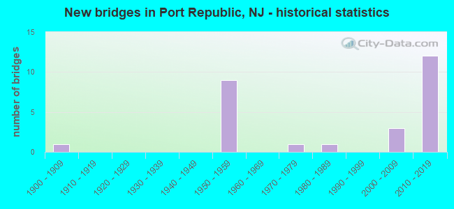
- New bridges - historical statistics
- 11900-1909
- 91950-1959
- 11970-1979
- 11980-1989
- 32000-2009
- 122010-2019

- Reconstructed bridges - Historical Statistics
- 11940-1949
- 01950-1959
- 01960-1969
- 01970-1979
- 01980-1989
- 01990-1999
- 22000-2009
- 22010-2019


- Bridge Condition - Deck
- 14.3%Very good
- 64.3%Good
- 21.4%Satisfactory

- Bridge Condition - Superstructure
- 21.4%Very good
- 42.9%Good
- 28.6%Satisfactory
- 7.1%Critical

- Bridge Condition - Substructure
- 21.4%Very good
- 42.9%Good
- 28.6%Satisfactory
- 7.1%Serious

- Bridge Condition - Channel
- 11.1%Excellent
- 22.2%Very good
- 55.6%Good
- 11.1%Satisfactory
Find on map >> Show street view
Structure Number: 102151, Location: 1.18 mi. s. of GSP (Lat: 39.532850, Lng: -74.463969), Route carried "on" structure: US 9, Year Built: 2002, Status: Open, Structure Length: 15.39m (50.49ft), Average Daily Traffic: 4,448 (year 2020), Truck Traffic: 4%, Average Future Daily Traffic: 5,338 (year 2040), Design Load: HL 93, Features Intersected: Nacote Ck & Lindbergh Av
Minimum Vertical Clearance: 30+ m (98+ ft), Kilometerpoint: 82.720, Lanes on structure: 2, Lanes under structure: 2, Base Highway Network: Yes, Owner: State Highway Agency, Approaching Roadway Width: 13.1m (43.0ft), Navigation Control: Yes ( Vertical Clearance: 7.6m (24.9ft), Horizontal Clearance: 28.3m (92.8ft)), Material/Design: Prestressed concrete continuous, Design/Construction: Stringer/Multi-beam, Number Of Spans In Main Unit: 5, Length of Maximum Span: 30.5m (100.1ft), Curb-To-Curb Width: 13.2m (43.3ft), Out-to-Out Width: 14.4m (47.2ft)
Condition: Deck: Satisfactory, Superstructure: Good, Substructure: Satisfactory, Channel: Excellent, Operating Rating: 76.1 metric tons, Method Used To Determine Operating Rating: Load and Resistance Factor Rating (LRFR) rating reported by rating factor(RF) method using HL-93 loadings, Inventory Rating: 60.3 metric tons, Method Used To Determine Inventory Rating: Load and Resistance Factor Rating (LRFR) rating reported by rating factor(RF) method using HL-93 loadings, Structural Evaluation: Equal to present minimum criteria, Deck Geometry: Equal to present minimum criteria, Underclear: Superior to present desirable criteria, Waterway Adequacy: Superior to present desirable criteria, Approach Roadway Alignment: Better than present minimum criteria, Designated Inspection Frequency: Every 24 months, Underwater Inspection Frequency: Every 48 months, Inspection Date: August 2020, Underwater Inspection Date: July 2018, Deck Structure Type: Concrete Cast-file-Place, Wearing Surface/Protective System: Deck Protection: Epoxy Coated Reinforcing
Find on map >> Show street view
Structure Number: 1PR004, Location: 0.1 MI S OF CR 575 (Lat: 39.517189, Lng: -74.496811), Route carried "on" structure: City street , Year Built: 1983, Status: Open, Structure Length: 0.70m (2.30ft), Average Daily Traffic: 422 (year 2021), Truck Traffic: 1%, Average Future Daily Traffic: 507 (year 2041), Design Load: HS 20+Mod, Features Intersected: NACOTE CREEK, Facility Carried by Structure: MILL ST
Minimum Vertical Clearance: 30+ m (98+ ft), Kilometerpoint: 0.000, Lanes on structure: 2, Owner: County Highway Agency, Approaching Roadway Width: 7.9m (25.9ft), Material/Design: Concrete, Design/Construction: Culvert, Number Of Spans In Main Unit: 1, Length of Maximum Span: 7.0m (23.0ft), Curb or Sidewalk Widths: Left: 0.0m, Right: 1.5m (4.9ft), Curb-To-Curb Width: 7.9m (25.9ft), Out-to-Out Width: 9.9m (32.5ft)
Condition: Channel: Good, Culverts: Satisfactory, Operating Rating: 89.8 metric tons, Method Used To Determine Operating Rating: Load Factor (LF), Inventory Rating: 57.2 metric tons, Method Used To Determine Inventory Rating: Load Factor (LF), Structural Evaluation: Equal to present minimum criteria, Deck Geometry: Somewhat better than minimum adequacy, Waterway Adequacy: Equal to present desirable criteria, Approach Roadway Alignment: Equal to present desirable criteria, Designated Inspection Frequency: Every 24 months, Underwater Inspection Frequency: Every 48 months, Inspection Date: Febuary 2021, Underwater Inspection Date: March 2021, Deck Structure Type: Concrete Cast-file-Place, Wearing Surface/Protective System: Wearing Surface: Monolithic Concrete
Find on map >> Show street view
Structure Number: 1PR007, Location: 0.28 Mi. So. of Main St. (Lat: 39.516331, Lng: -74.484439), Route carried "on" structure: County highway 610, Year Built: 1904, Year Reconstructed: 1952, Status: Closed, Structure Length: 13.08m (42.91ft), Average Daily Traffic: 1,117 (year 2019), Truck Traffic: 3%, Average Future Daily Traffic: 1,340 (year 2039), Features Intersected: NACOTE CREEK, Facility Carried by Structure: OLD NEW YORK ROAD
Minimum Vertical Clearance: 30+ m (98+ ft), Kilometerpoint: 3.460, Lanes on structure: 2, Owner: County Highway Agency, Approaching Roadway Width: 8.2m (26.9ft), Material/Design: Steel, Design/Construction: Girder and Floorbeam System, Number Of Spans In Main Unit: 2, Number Of Approach Spans: 23, Length of Maximum Span: 12.8m (42.0ft), Curb-To-Curb Width: 5.4m (17.7ft), Out-to-Out Width: 5.6m (18.4ft)
Condition: Deck: Satisfactory, Superstructure: Critical, Substructure: Serious, Channel: Good, Operating Rating: 13.6 metric tons, Method Used To Determine Operating Rating: Load Factor (LF), Inventory Rating: 8.2 metric tons, Method Used To Determine Inventory Rating: Load Factor (LF), Waterway Adequacy: Equal to present desirable criteria, Approach Roadway Alignment: Equal to present minimum criteria, Bridge Posting: Required (Relationship of Operating Rating to Maximum Legal Load: 30.0 - 39.9% below), Length Of Structure Improvement: 20.91m (68.60ft), Designated Inspection Frequency: Every 24 months, Critical Feature Inspection Frequency: Every 24 months, Underwater Inspection Frequency: Every 48 months, Inspection Date: Febuary 2019, Critical Feature Inspection Date: Febuary 2019, Underwater Inspection Date: Febuary 2017, Bridge Improvement Cost: $11,319,000, Roadway Improvement Cost: $1,132,000, Total Project Cost: $17,600,000 ( Estimate for 2019), Deck Structure Type: Wood or Timber, Wearing Surface/Protective System: Wearing Surface: Bituminous
Find on map >> Show street view
Structure Number: 30215, Location: 0.46 MI EAST OF C.R. 679 (Lat: 39.593319, Lng: -74.442919), Route carried "on" structure: US 9, Year Built: 2005, Status: Open, Structure Length: 14.26m (46.78ft), Average Daily Traffic: 9,750 (year 2020), Truck Traffic: 4%, Average Future Daily Traffic: 11,900 (year 2040), Design Load: HS 25 or greater, Features Intersected: BASS RIVER
Minimum Vertical Clearance: 30+ m (98+ ft), Kilometerpoint: 91.829, Lanes on structure: 2, Base Highway Network: Yes, Owner: State Highway Agency, Approaching Roadway Width: 13.1m (43.0ft), Skew: 1 degrees, Navigation Control: Yes ( Vertical Clearance: 5.5m (18.0ft), Horizontal Clearance: 15.2m (49.9ft)), Material/Design: Prestressed concrete continuous, Design/Construction: Box Beam or Girders - Multiple, Number Of Spans In Main Unit: 5, Number Of Approach Spans: 3, Length of Maximum Span: 34.4m (112.9ft), Curb or Sidewalk Widths: Left: 0.0m, Right: 1.8m (5.9ft), Curb-To-Curb Width: 13.2m (43.3ft), Out-to-Out Width: 15.9m (52.2ft)
Condition: Deck: Good, Superstructure: Very good, Substructure: Good, Channel: Very good, Operating Rating: 87.1 metric tons, Method Used To Determine Operating Rating: Load Factor (LF), Inventory Rating: 50.8 metric tons, Method Used To Determine Inventory Rating: Load Factor (LF), Structural Evaluation: Better than present minimum criteria, Deck Geometry: Somewhat better than minimum adequacy, Waterway Adequacy: Equal to present desirable criteria, Approach Roadway Alignment: Equal to present desirable criteria, Designated Inspection Frequency: Every 24 months, Underwater Inspection Frequency: Every 48 months, Inspection Date: May 2020, Underwater Inspection Date: March 2020, Deck Structure Type: Concrete Cast-file-Place, Wearing Surface/Protective System: Wearing Surface: Monolithic Concrete, Deck Protection: Epoxy Coated Reinforcing
Find on map >> Show street view
Structure Number: 3H852, Location: 1.43 MI W OF US RT 9 (Lat: 39.600089, Lng: -74.480181), Route carried "on" structure: County highway 542, Year Built: 1975, Status: Open, Structure Length: 1.98m (6.50ft), Average Daily Traffic: 2,731 (year 2019), Truck Traffic: 3%, Average Future Daily Traffic: 3,277 (year 2039), Design Load: HS 20+Mod, Features Intersected: MERRYGOLD BR.WADING RIV
Minimum Vertical Clearance: 30+ m (98+ ft), Kilometerpoint: 30.803, Lanes on structure: 2, Owner: County Highway Agency, Approaching Roadway Width: 7.3m (24.0ft), Material/Design: Prestressed concrete, Design/Construction: Slab, Number Of Spans In Main Unit: 4, Length of Maximum Span: 4.9m (16.1ft), Curb-To-Curb Width: 7.7m (25.3ft), Out-to-Out Width: 7.9m (25.9ft)
Condition: Deck: Satisfactory, Superstructure: Satisfactory, Substructure: Satisfactory, Channel: Good, Operating Rating: 54.4 metric tons, Method Used To Determine Operating Rating: Field evaluation and documented engineering judgment, Inventory Rating: 32.7 metric tons, Method Used To Determine Inventory Rating: Field evaluation and documented engineering judgment, Structural Evaluation: Equal to present minimum criteria, Deck Geometry: High priority of replacement, Waterway Adequacy: Equal to present minimum criteria, Approach Roadway Alignment: Equal to present desirable criteria, Length Of Structure Improvement: 1.98m (6.50ft), Designated Inspection Frequency: Every 24 months, Underwater Inspection Frequency: Every 48 months, Inspection Date: November 2021, Underwater Inspection Date: January 2020, Bridge Improvement Cost: $208,000, Roadway Improvement Cost: $100,000, Total Project Cost: $446,000 ( Estimate for 2019), Deck Structure Type: Concrete Precast Panels, Wearing Surface/Protective System: Wearing Surface: Bituminous
Find on map >> Show street view
Structure Number: 360459N, Location: 2.35 MI SW OF RT9 RAMP (Lat: 39.527889, Lng: -74.501667), Route carried "on" structure: Other road GSP, Year Built: 1954, Year Reconstructed: 2015, Status: Open, Structure Length: 1.65m (5.41ft), Average Daily Traffic: 26,052 (year 2021), Truck Traffic: 3%, Average Future Daily Traffic: 31,790 (year 2041), Features Intersected: CLARKS LANDING RD (C624)
Minimum Vertical Clearance: 30+ m (98+ ft), Kilometerpoint: 73.933, Lanes on structure: 3, Lanes under structure: 2, Base Highway Network: Yes, Toll: On toll road, Owner: State Toll Authority, Approaching Roadway Width: 18.6m (61.0ft), Skew: 1 degrees, Material/Design: Steel, Design/Construction: Stringer/Multi-beam, Number Of Spans In Main Unit: 1, Length of Maximum Span: 14.6m (47.9ft), Curb-To-Curb Width: 18.6m (61.0ft), Out-to-Out Width: 19.8m (65.0ft)
Condition: Deck: Good, Superstructure: Good, Substructure: Good, Operating Rating: 58.0 metric tons, Method Used To Determine Operating Rating: Load and Resistance Factor Rating (LRFR) rating reported by rating factor(RF) method using HL-93 loadings, Inventory Rating: 44.4 metric tons, Method Used To Determine Inventory Rating: Load and Resistance Factor Rating (LRFR) rating reported by rating factor(RF) method using HL-93 loadings, Structural Evaluation: Better than present minimum criteria, Deck Geometry: Superior to present desirable criteria, Underclear: Somewhat better than minimum adequacy, Approach Roadway Alignment: Equal to present desirable criteria, Designated Inspection Frequency: Every 24 months, Inspection Date: March 2021, Deck Structure Type: Concrete Cast-file-Place, Wearing Surface/Protective System: Wearing Surface: Monolithic Concrete, Deck Protection: Epoxy Coated Reinforcing
Find on map >> Show street view
Structure Number: 360460S, Location: 2.35 MI SW OF US 9 RAMP (Lat: 39.528403, Lng: -74.502164), Route carried "on" structure: Other road GSP, Year Built: 1954, Year Reconstructed: 2015, Status: Open, Structure Length: 1.55m (5.09ft), Average Daily Traffic: 41,175 (year 2021), Truck Traffic: 3%, Average Future Daily Traffic: 50,242 (year 2041), Features Intersected: CLARKS LANDING RD (C614)
Minimum Vertical Clearance: 30+ m (98+ ft), Kilometerpoint: 73.933, Lanes on structure: 3, Lanes under structure: 2, Base Highway Network: Yes, Toll: On toll road, Owner: State Toll Authority, Approaching Roadway Width: 18.5m (60.7ft), Skew: 1 degrees, Material/Design: Steel, Design/Construction: Stringer/Multi-beam, Number Of Spans In Main Unit: 1, Length of Maximum Span: 14.6m (47.9ft), Curb-To-Curb Width: 18.5m (60.7ft), Out-to-Out Width: 19.7m (64.6ft)
Condition: Deck: Very good, Superstructure: Good, Substructure: Good, Operating Rating: 60.6 metric tons, Method Used To Determine Operating Rating: Load and Resistance Factor Rating (LRFR) rating reported by rating factor(RF) method using HL-93 loadings, Inventory Rating: 46.7 metric tons, Method Used To Determine Inventory Rating: Load and Resistance Factor Rating (LRFR) rating reported by rating factor(RF) method using HL-93 loadings, Structural Evaluation: Better than present minimum criteria, Deck Geometry: Superior to present desirable criteria, Underclear: Somewhat better than minimum adequacy, Approach Roadway Alignment: Equal to present desirable criteria, Designated Inspection Frequency: Every 24 months, Inspection Date: March 2021, Deck Structure Type: Concrete Cast-file-Place, Wearing Surface/Protective System: Wearing Surface: Monolithic Concrete, Deck Protection: Epoxy Coated Reinforcing
Find on map >> Show street view
Structure Number: 360483T, Location: 0.6 MI S OF MULLICA RIVER (Lat: 39.547347, Lng: -74.466703), Route carried "on" structure: US 9, Year Built: 2013, Status: Open, Structure Length: 5.85m (19.19ft), Average Daily Traffic: 2,296 (year 2021), Truck Traffic: 4%, Average Future Daily Traffic: 2,802 (year 2041), Design Load: HL 93, Features Intersected: GSP
Minimum Vertical Clearance: 30+ m (98+ ft), Kilometerpoint: 84.635, Lanes on structure: 1, Lanes under structure: 7, Base Highway Network: Yes, Owner: State Toll Authority, Approaching Roadway Width: 7.9m (25.9ft), Material/Design: Steel continuous, Design/Construction: Stringer/Multi-beam, Number Of Spans In Main Unit: 2, Length of Maximum Span: 28.7m (94.2ft), Curb-To-Curb Width: 7.9m (25.9ft), Out-to-Out Width: 9.1m (29.9ft)
Condition: Deck: Good, Superstructure: Satisfactory, Substructure: Good, Operating Rating: 54.1 metric tons, Method Used To Determine Operating Rating: Load and Resistance Factor Rating (LRFR) rating reported by rating factor(RF) method using HL-93 loadings, Inventory Rating: 41.5 metric tons, Method Used To Determine Inventory Rating: Load and Resistance Factor Rating (LRFR) rating reported by rating factor(RF) method using HL-93 loadings, Structural Evaluation: Equal to present minimum criteria, Deck Geometry: High priority of corrective action, Underclear: Better than present minimum criteria, Approach Roadway Alignment: Equal to present desirable criteria, Designated Inspection Frequency: Every 24 months, Inspection Date: March 2021, Deck Structure Type: Concrete Cast-file-Place, Wearing Surface/Protective System: Wearing Surface: Monolithic Concrete, Deck Protection: Epoxy Coated Reinforcing
Find on map >> Show street view
Structure Number: 360490N, Location: 4.6 MI SO NEW GRETNA TOLL (Lat: 39.556667, Lng: -74.000000), Route carried "on" structure: Other road GSP, Year Built: 2011, Status: Open, Structure Length: 37.49m (123.00ft), Average Daily Traffic: 20,000 (year 2021), Truck Traffic: 3%, Average Future Daily Traffic: 26,937 (year 2041), Design Load: HL 93, Features Intersected: MULLICA RIVER, Facility Carried by Structure: Parkway N
Minimum Vertical Clearance: 30+ m (98+ ft), Kilometerpoint: 78.858, Lanes on structure: 3, Base Highway Network: Yes, Toll: On toll road, Owner: State Toll Authority, Approaching Roadway Width: 16.2m (53.1ft), Navigation Control: Yes ( Vertical Clearance: 10.1m (33.1ft), Horizontal Clearance: 24.4m (80.1ft)), Material/Design: Prestressed concrete continuous, Design/Construction: Stringer/Multi-beam, Number Of Spans In Main Unit: 6, Length of Maximum Span: 67.1m (220.1ft), Curb-To-Curb Width: 16.2m (53.1ft), Out-to-Out Width: 17.3m (56.8ft)
Condition: Deck: Good, Superstructure: Good, Substructure: Good, Channel: Good, Operating Rating: 57.0 metric tons, Method Used To Determine Operating Rating: Load and Resistance Factor Rating (LRFR) rating reported by rating factor(RF) method using HL-93 loadings, Inventory Rating: 43.7 metric tons, Method Used To Determine Inventory Rating: Load and Resistance Factor Rating (LRFR) rating reported by rating factor(RF) method using HL-93 loadings, Structural Evaluation: Better than present minimum criteria, Deck Geometry: Better than present minimum criteria, Waterway Adequacy: Superior to present desirable criteria, Approach Roadway Alignment: Equal to present desirable criteria, Designated Inspection Frequency: Every 24 months, Underwater Inspection Frequency: Every 48 months, Inspection Date: June 2021, Underwater Inspection Date: September 2021, Deck Structure Type: Concrete Cast-file-Place, Wearing Surface/Protective System: Deck Protection: Epoxy Coated Reinforcing
Find on map >> Show street view
Structure Number: 360490S, Location: 4.6 MI SO NEW GRETNA TOLL (Lat: 39.556667, Lng: -74.000000), Route carried "on" structure: Other road GSP, Year Built: 1954, Year Reconstructed: 2013, Status: Open, Structure Length: 29.84m (97.90ft), Average Daily Traffic: 25,000 (year 2021), Truck Traffic: 3%, Average Future Daily Traffic: 33,671 (year 2041), Design Load: HS 20, Features Intersected: MULLICA RIVER, Facility Carried by Structure: PARKWAY S
Minimum Vertical Clearance: 30+ m (98+ ft), Kilometerpoint: 78.777, Lanes on structure: 3, Base Highway Network: Yes, Toll: On toll road, Owner: State Toll Authority, Approaching Roadway Width: 17.7m (58.1ft), Navigation Control: Yes ( Vertical Clearance: 10.1m (33.1ft), Horizontal Clearance: 24.4m (80.1ft)), Material/Design: Steel, Design/Construction: Girder and Floorbeam System, Number Of Spans In Main Unit: 8, Number Of Approach Spans: 4, Length of Maximum Span: 32.9m (107.9ft), Curb-To-Curb Width: 17.7m (58.1ft), Out-to-Out Width: 18.8m (61.7ft)
Condition: Deck: Good, Superstructure: Satisfactory, Substructure: Satisfactory, Channel: Satisfactory, Operating Rating: 44.4 metric tons, Method Used To Determine Operating Rating: Load and Resistance Factor Rating (LRFR) rating reported by rating factor(RF) method using HL-93 loadings, Inventory Rating: 34.3 metric tons, Method Used To Determine Inventory Rating: Load and Resistance Factor Rating (LRFR) rating reported by rating factor(RF) method using HL-93 loadings, Structural Evaluation: Equal to present minimum criteria, Deck Geometry: Superior to present desirable criteria, Waterway Adequacy: Equal to present desirable criteria, Approach Roadway Alignment: Equal to present desirable criteria, Designated Inspection Frequency: Every 24 months, Critical Feature Inspection Frequency: Every 24 months, Underwater Inspection Frequency: Every 48 months, Inspection Date: June 2021, Critical Feature Inspection Date: June 2021, Underwater Inspection Date: September 2021, Deck Structure Type: Concrete Cast-file-Place, Wearing Surface/Protective System: Wearing Surface: Monolithic Concrete, Deck Protection: Epoxy Coated Reinforcing
Find on map >> Show street view
Structure Number: 360507T, Location: 1.1 MI S OF US9 & GSP JCT (Lat: 39.580039, Lng: -74.457314), Route carried "on" structure: US 9, Year Built: 2013, Status: Open, Structure Length: 5.03m (16.50ft), Average Daily Traffic: 8,404 (year 2021), Truck Traffic: 4%, Average Future Daily Traffic: 10,254 (year 2041), Design Load: HL 93, Features Intersected: GSP
Minimum Vertical Clearance: 30+ m (98+ ft), Kilometerpoint: 88.739, Lanes on structure: 2, Lanes under structure: 7, Base Highway Network: Yes, Owner: State Toll Authority, Approaching Roadway Width: 13.4m (44.0ft), Material/Design: Steel continuous, Design/Construction: Stringer/Multi-beam, Number Of Spans In Main Unit: 2, Length of Maximum Span: 24.4m (80.1ft), Curb-To-Curb Width: 13.4m (44.0ft), Out-to-Out Width: 14.5m (47.6ft)
Condition: Deck: Very good, Superstructure: Very good, Substructure: Very good, Operating Rating: 59.9 metric tons, Method Used To Determine Operating Rating: Load and Resistance Factor Rating (LRFR) rating reported by rating factor(RF) method using HL-93 loadings, Inventory Rating: 46.3 metric tons, Method Used To Determine Inventory Rating: Load and Resistance Factor Rating (LRFR) rating reported by rating factor(RF) method using HL-93 loadings, Structural Evaluation: Equal to present desirable criteria, Deck Geometry: Equal to present minimum criteria, Underclear: Somewhat better than minimum adequacy, Approach Roadway Alignment: Equal to present desirable criteria, Designated Inspection Frequency: Every 24 months, Inspection Date: March 2021, Deck Structure Type: Concrete Cast-file-Place, Wearing Surface/Protective System: Wearing Surface: Monolithic Concrete, Deck Protection: Epoxy Coated Reinforcing
Find on map >> Show street view
Structure Number: 360519N, Location: 1.7 MI SO NEW GRETNA TOLL (Lat: 39.592739, Lng: -74.444344), Route carried "on" structure: Other road GSP, Year Built: 2013, Status: Open, Structure Length: 30.11m (98.79ft), Average Daily Traffic: 20,446 (year 2021), Truck Traffic: 3%, Average Future Daily Traffic: 24,945 (year 2041), Design Load: HL 93, Features Intersected: BASS R,US9,W GREENBSH RD, Facility Carried by Structure: PARKWAY N
Minimum Vertical Clearance: 30+ m (98+ ft), Kilometerpoint: 83.396, Lanes on structure: 3, Lanes under structure: 4, Base Highway Network: Yes, Toll: On toll road, Owner: State Toll Authority, Approaching Roadway Width: 16.2m (53.1ft), Navigation Control: Yes ( Vertical Clearance: 8.8m (28.9ft), Horizontal Clearance: 32.0m (105.0ft)), Material/Design: Prestressed concrete continuous, Design/Construction: Stringer/Multi-beam, Number Of Spans In Main Unit: 6, Length of Maximum Span: 61.0m (200.1ft), Curb-To-Curb Width: 16.2m (53.1ft), Out-to-Out Width: 17.3m (56.8ft)
Condition: Deck: Good, Superstructure: Good, Substructure: Good, Channel: Very good, Operating Rating: 42.4 metric tons, Method Used To Determine Operating Rating: Load and Resistance Factor Rating (LRFR) rating reported by rating factor(RF) method using HL-93 loadings, Inventory Rating: 32.7 metric tons, Method Used To Determine Inventory Rating: Load and Resistance Factor Rating (LRFR) rating reported by rating factor(RF) method using HL-93 loadings, Structural Evaluation: Better than present minimum criteria, Deck Geometry: Better than present minimum criteria, Underclear: Meets minimum limits, Waterway Adequacy: Superior to present desirable criteria, Approach Roadway Alignment: Equal to present desirable criteria, Designated Inspection Frequency: Every 24 months, Underwater Inspection Frequency: Every 48 months, Inspection Date: June 2021, Underwater Inspection Date: August 2021, Deck Structure Type: Concrete Cast-file-Place, Wearing Surface/Protective System: Wearing Surface: Monolithic Concrete, Deck Protection: Epoxy Coated Reinforcing
Find on map >> Show street view
Structure Number: 360519S, Location: 1.7 MI SO NEW GRETNA TOLL (Lat: 39.592839, Lng: -74.444511), Route carried "on" structure: Other road GSP, Year Built: 1954, Year Reconstructed: 2013, Status: Open, Structure Length: 27.13m (89.01ft), Average Daily Traffic: 20,045 (year 2021), Truck Traffic: 3%, Average Future Daily Traffic: 24,458 (year 2041), Design Load: HS 20, Features Intersected: BASS R,US9,W GREENBSH RD, Facility Carried by Structure: SB GARDEN ST PKWY
Minimum Vertical Clearance: 30+ m (98+ ft), Kilometerpoint: 83.396, Lanes on structure: 3, Lanes under structure: 6, Base Highway Network: Yes, Toll: On toll road, Owner: State Toll Authority, Approaching Roadway Width: 19.8m (65.0ft), Navigation Control: Yes ( Vertical Clearance: 8.8m (28.9ft), Horizontal Clearance: 32.0m (105.0ft)), Material/Design: Steel, Design/Construction: Girder and Floorbeam System, Number Of Spans In Main Unit: 7, Number Of Approach Spans: 1, Length of Maximum Span: 37.8m (124.0ft), Curb-To-Curb Width: 17.7m (58.1ft), Out-to-Out Width: 18.8m (61.7ft)
Condition: Deck: Good, Superstructure: Satisfactory, Substructure: Satisfactory, Channel: Good, Operating Rating: 26.9 metric tons, Method Used To Determine Operating Rating: Load and Resistance Factor Rating (LRFR) rating reported by rating factor(RF) method using HL-93 loadings, Inventory Rating: 20.4 metric tons, Method Used To Determine Inventory Rating: Load and Resistance Factor Rating (LRFR) rating reported by rating factor(RF) method using HL-93 loadings, Structural Evaluation: Somewhat better than minimum adequacy, Deck Geometry: Superior to present desirable criteria, Underclear: High priority of corrective action, Waterway Adequacy: Superior to present desirable criteria, Approach Roadway Alignment: Equal to present desirable criteria, Length Of Structure Improvement: 1.22m (4.00ft), Designated Inspection Frequency: Every 24 months, Critical Feature Inspection Frequency: Every 24 months, Underwater Inspection Frequency: Every 48 months, Inspection Date: June 2021, Critical Feature Inspection Date: June 2021, Underwater Inspection Date: August 2021, Bridge Improvement Cost: $150,000, Roadway Improvement Cost: $150,000, Total Project Cost: $300,000 ( Estimate for 2015), Deck Structure Type: Concrete Cast-file-Place, Wearing Surface/Protective System: Wearing Surface: Monolithic Concrete, Deck Protection: Epoxy Coated Reinforcing
Find on map >> Show street view
Structure Number: 370440N, Location: 4 MI N OF US30&GSP JCT (Lat: 39.505919, Lng: -74.518794), Route carried "on" structure: Alternate County highway 561, Year Built: 2015, Status: Open, Structure Length: 3.14m (10.30ft), Average Daily Traffic: 6,341 (year 2021), Truck Traffic: 4%, Average Future Daily Traffic: 7,738 (year 2041), Design Load: HL 93, Features Intersected: GSP NB
Minimum Vertical Clearance: 30+ m (98+ ft), Kilometerpoint: 10.268, Lanes on structure: 2, Lanes under structure: 4, Owner: State Toll Authority, Approaching Roadway Width: 15.8m (51.8ft), Skew: 2 degrees, Material/Design: Steel, Design/Construction: Stringer/Multi-beam, Number Of Spans In Main Unit: 1, Length of Maximum Span: 29.3m (96.1ft), Curb or Sidewalk Widths: Left: 0.0m, Right: 1.8m (5.9ft), Curb-To-Curb Width: 15.8m (51.8ft), Out-to-Out Width: 18.5m (60.7ft)
Condition: Deck: Good, Superstructure: Good, Substructure: Very good, Operating Rating: 62.2 metric tons, Method Used To Determine Operating Rating: Load and Resistance Factor Rating (LRFR) rating reported by rating factor(RF) method using HL-93 loadings, Inventory Rating: 48.0 metric tons, Method Used To Determine Inventory Rating: Load and Resistance Factor Rating (LRFR) rating reported by rating factor(RF) method using HL-93 loadings, Structural Evaluation: Better than present minimum criteria, Deck Geometry: Superior to present desirable criteria, Underclear: Equal to present minimum criteria, Approach Roadway Alignment: Equal to present desirable criteria, Designated Inspection Frequency: Every 24 months, Inspection Date: March 2021, Deck Structure Type: Concrete Cast-file-Place, Wearing Surface/Protective System: Wearing Surface: Monolithic Concrete, Deck Protection: Epoxy Coated Reinforcing
Find on map >> Show street view
Structure Number: 370440S, Location: 4 MI N OF US30&GSP JCT (Lat: 39.505547, Lng: -74.519658), Route carried "on" structure: Alternate County highway 561, Year Built: 2015, Status: Open, Structure Length: 3.14m (10.30ft), Average Daily Traffic: 6,341 (year 2021), Truck Traffic: 4%, Average Future Daily Traffic: 7,738 (year 2041), Design Load: HL 93, Features Intersected: GSP SB
Minimum Vertical Clearance: 30+ m (98+ ft), Kilometerpoint: 10.348, Lanes on structure: 3, Lanes under structure: 4, Owner: State Toll Authority, Approaching Roadway Width: 18.0m (59.1ft), Skew: 2 degrees, Material/Design: Steel, Design/Construction: Stringer/Multi-beam, Number Of Spans In Main Unit: 1, Length of Maximum Span: 29.3m (96.1ft), Curb or Sidewalk Widths: Left: 0.0m, Right: 1.8m (5.9ft), Curb-To-Curb Width: 18.0m (59.1ft), Out-to-Out Width: 20.7m (67.9ft)
Condition: Deck: Good, Superstructure: Very good, Substructure: Very good, Operating Rating: 63.5 metric tons, Method Used To Determine Operating Rating: Load and Resistance Factor Rating (LRFR) rating reported by rating factor(RF) method using HL-93 loadings, Inventory Rating: 48.9 metric tons, Method Used To Determine Inventory Rating: Load and Resistance Factor Rating (LRFR) rating reported by rating factor(RF) method using HL-93 loadings, Structural Evaluation: Equal to present desirable criteria, Deck Geometry: Superior to present desirable criteria, Underclear: Somewhat better than minimum adequacy, Approach Roadway Alignment: Equal to present desirable criteria, Designated Inspection Frequency: Every 24 months, Inspection Date: March 2021, Deck Structure Type: Concrete Cast-file-Place, Wearing Surface/Protective System: Wearing Surface: Monolithic Concrete, Deck Protection: Epoxy Coated Reinforcing
Find on map >> Show street view
Structure Number: 102151, Location: 1.18 mi. s. of GSP (Lat: 39.532850, Lng: -74.463969), Route carried "under" structure: Other road , Year Built: 2002, Structure Length: 0. m, Average Daily Traffic: 26 (year 2020), Features Intersected: Nacote Ck & Lindbergh Av, Facility Carried by Structure: US 9
Minimum Vertical Clearance: 7.01m (23.00ft), Kilometerpoint: 0.000, Lanes on structure: 2, Lanes under structure: 2, Material/Design: Prestressed concrete continuous, Design/Construction: Stringer/Multi-beam, Length of Maximum Span: 30.5m (100.1ft)
Find on map >> Show street view
Structure Number: 360459N, Location: 2.35 MI SW OF RT9 RAMP (Lat: 39.527889, Lng: -74.501667), Route carried "under" structure: County highway 624, Year Built: 1954, Structure Length: 0. m, Average Daily Traffic: 1,143 (year 2021), Truck Traffic: 4%, Features Intersected: CLARKS LANDING RD (C624), Facility Carried by Structure: GSP NB
Minimum Vertical Clearance: 4.62m (15.16ft), Kilometerpoint: 10.783, Lanes on structure: 3, Lanes under structure: 2, Material/Design: Steel, Design/Construction: Stringer/Multi-beam, Length of Maximum Span: 14.6m (47.9ft)
Find on map >> Show street view
Structure Number: 360460S, Location: 2.35 MI SW OF US 9 RAMP (Lat: 39.528403, Lng: -74.502164), Route carried "under" structure: County highway 624, Year Built: 1954, Structure Length: 0. m, Average Daily Traffic: 1,143 (year 2021), Truck Traffic: 4%, Features Intersected: CLARKS LANDING RD (C614), Facility Carried by Structure: GSP SB
Minimum Vertical Clearance: 4.70m (15.42ft), Kilometerpoint: 10.783, Lanes on structure: 3, Lanes under structure: 2, Material/Design: Steel, Design/Construction: Stringer/Multi-beam, Length of Maximum Span: 14.6m (47.9ft)
Find on map >> Show street view
Structure Number: 360483T, Location: 0.6 MI S OF MULLICA RIVER (Lat: 39.547347, Lng: -74.466703), Route carried "under" structure: Other road GSP, Year Built: 2013, Structure Length: 0. m, Average Daily Traffic: 72,060 (year 2021), Truck Traffic: 3%, Features Intersected: GSP, Facility Carried by Structure: US 9 SB
Minimum Vertical Clearance: 5.64m (18.50ft), Kilometerpoint: 77.715, Lanes on structure: 1, Lanes under structure: 7, Toll: On toll road, Material/Design: Steel continuous, Design/Construction: Stringer/Multi-beam, Length of Maximum Span: 28.7m (94.2ft)
Find on map >> Show street view
Structure Number: 360507T, Location: 1.1 MI S OF US9 & GSP JCT (Lat: 39.580039, Lng: -74.457314), Route carried "under" structure: Other road GSP, Year Built: 2013, Structure Length: 0. m, Average Daily Traffic: 48,136 (year 2021), Truck Traffic: 3%, Features Intersected: GSP, Facility Carried by Structure: US 9
Minimum Vertical Clearance: 5.84m (19.16ft), Kilometerpoint: 81.545, Lanes on structure: 2, Lanes under structure: 7, Toll: On toll road, Material/Design: Steel continuous, Design/Construction: Stringer/Multi-beam, Length of Maximum Span: 24.4m (80.1ft)
Find on map >> Show street view
Structure Number: 360519N, Location: 1.7 MI SO NEW GRETNA TOLL (Lat: 39.592739, Lng: -74.444344), Route carried "under" structure: US 9, Year Built: 2013, Structure Length: 0. m, Average Daily Traffic: 6,936 (year 2021), Truck Traffic: 4%, Features Intersected: BASS R,US9,W GREENBSH RD, Facility Carried by Structure: PARKWAY N
Minimum Vertical Clearance: 6.10m (20.01ft), Kilometerpoint: 91.700, Lanes on structure: 3, Lanes under structure: 2, Material/Design: Prestressed concrete continuous, Design/Construction: Stringer/Multi-beam, Length of Maximum Span: 61.0m (200.1ft)
Find on map >> Show street view
Structure Number: 360519N, Location: 1.7 MI SO NEW GRETNA TOLL (Lat: 39.592739, Lng: -74.444344), Route carried "under" structure: City street , Year Built: 2013, Structure Length: 0. m, Average Daily Traffic: 102 (year 2021), Truck Traffic: 3%, Features Intersected: BASS R,US9,W GREENBSH RD, Facility Carried by Structure: PARKWAY N
Minimum Vertical Clearance: 6.25m (20.51ft), Kilometerpoint: 0.000, Lanes on structure: 3, Lanes under structure: 2, Material/Design: Prestressed concrete continuous, Design/Construction: Stringer/Multi-beam, Length of Maximum Span: 61.0m (200.1ft)
Find on map >> Show street view
Structure Number: 360519S, Location: 1.7 MI SO NEW GRETNA TOLL (Lat: 39.592839, Lng: -74.444511), Route carried "under" structure: City street , Year Built: 1954, Structure Length: 0. m, Average Daily Traffic: 108 (year 2021), Truck Traffic: 3%, Features Intersected: BASS R,US9,W GREENBSH RD, Facility Carried by Structure: SB GARDEN ST PKWY
Minimum Vertical Clearance: 3.89m (12.76ft), Kilometerpoint: 0.000, Lanes on structure: 3, Lanes under structure: 2, Material/Design: Steel, Design/Construction: Girder and Floorbeam System, Length of Maximum Span: 37.8m (124.0ft)
Find on map >> Show street view
Structure Number: 360519S, Location: 1.7 MI SO NEW GRETNA TOLL (Lat: 39.592839, Lng: -74.444511), Route carried "under" structure: US 9, Year Built: 1954, Structure Length: 0. m, Average Daily Traffic: 7,075 (year 2021), Truck Traffic: 4%, Features Intersected: BASS R,US9,W GREENBSH RD, Facility Carried by Structure: SB GARDEN ST PKWY
Minimum Vertical Clearance: 5.08m (16.67ft), Kilometerpoint: 91.700, Lanes on structure: 3, Lanes under structure: 2, Material/Design: Steel, Design/Construction: Girder and Floorbeam System, Length of Maximum Span: 37.8m (124.0ft)
Find on map >> Show street view
Structure Number: 360519S, Location: 1.7 MI SO NEW GRETNA TOLL (Lat: 39.592839, Lng: -74.444511), Route carried "under" structure: Other road , Year Built: 1954, Structure Length: 0. m, Average Daily Traffic: 250 (year 2021), Truck Traffic: 1%, Features Intersected: BASS R,US9,W GREENBSH RD, Facility Carried by Structure: SB GARDEN ST PKWY
Minimum Vertical Clearance: 5.08m (16.67ft), Kilometerpoint: 0.000, Lanes on structure: 3, Lanes under structure: 2, Material/Design: Steel, Design/Construction: Girder and Floorbeam System, Length of Maximum Span: 37.8m (124.0ft)
Find on map >> Show street view
Structure Number: 370440N, Location: 4 MI N OF US30&GSP JCT (Lat: 39.505919, Lng: -74.518794), Route carried "under" structure: Other road GSP, Year Built: 2015, Structure Length: 0. m, Average Daily Traffic: 36,197 (year 2021), Truck Traffic: 3%, Features Intersected: GSP NB, Facility Carried by Structure: POMONA RD (CR561A)
Minimum Vertical Clearance: 5.56m (18.24ft), Kilometerpoint: 70.811, Lanes on structure: 2, Lanes under structure: 4, Toll: On toll road, Material/Design: Steel, Design/Construction: Stringer/Multi-beam, Length of Maximum Span: 29.3m (96.1ft)
Find on map >> Show street view
Structure Number: 370440S, Location: 4 MI N OF US30&GSP JCT (Lat: 39.505547, Lng: -74.519658), Route carried "under" structure: Other road GSP, Year Built: 2015, Structure Length: 0. m, Average Daily Traffic: 36,187 (year 2021), Truck Traffic: 3%, Features Intersected: GSP SB, Facility Carried by Structure: POMONA RD (CR561A)
Minimum Vertical Clearance: 5.26m (17.26ft), Kilometerpoint: 70.811, Lanes on structure: 3, Lanes under structure: 4, Toll: On toll road, Material/Design: Steel, Design/Construction: Stringer/Multi-beam, Length of Maximum Span: 29.3m (96.1ft)