Bridge Statistics for Port Washington, Ohio (OH)
Condition, Traffic, Stress, Structural Evaluation, Project Costs
- National Bridge Inventory (NBI) Statistics
- 14Number of bridges
- 121ft / 36.6mTotal length
- 52,054Total average daily traffic
- 5,888Total average daily truck traffic
- National Bridge Inventory (NBI) Registered Bridges for Port Washington
- No street view available for this location
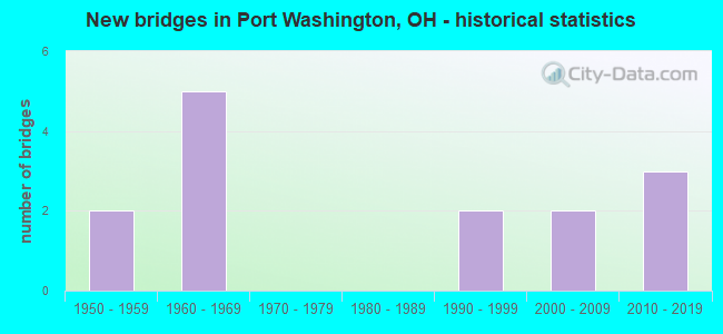
- New bridges - historical statistics
- 21950-1959
- 51960-1969
- 21990-1999
- 22000-2009
- 32010-2019


- Bridge Condition - Deck
- 25.0%Excellent
- 33.3%Very good
- 25.0%Good
- 8.3%Satisfactory
- 8.3%Fair

- Bridge Condition - Superstructure
- 25.0%Excellent
- 41.7%Very good
- 25.0%Good
- 8.3%Satisfactory

- Bridge Condition - Substructure
- 33.3%Excellent
- 33.3%Very good
- 25.0%Good
- 8.3%Satisfactory

- Bridge Condition - Channel
- 7.7%Excellent
- 7.7%Very good
- 7.7%Good
- 76.9%Satisfactory
Find on map >> Show street view
Structure Number: 7900287, Location: 3.79 MI W OF JCT SR416 (Lat: 40.337211, Lng: -81.510781), Route carried "on" structure: US 36, Year Built: 2013, Status: Open, Structure Length: 0.76m (2.49ft), Average Daily Traffic: 5,215 (year 2015), Truck Traffic: 18%, Average Future Daily Traffic: 7,238 (year 2035), Design Load: HL 93, Features Intersected: TRIB TUSCARAWAS RIVER
Minimum Vertical Clearance: 30+ m (98+ ft), Kilometerpoint: 12.376, Lanes on structure: 2, Base Highway Network: Yes, Owner: State Highway Agency, Approaching Roadway Width: 11.3m (37.1ft), Skew: 5 degrees, Material/Design: Concrete, Design/Construction: Frame, Number Of Spans In Main Unit: 1, Length of Maximum Span: 4.9m (16.1ft), Curb-To-Curb Width: 11.3m (37.1ft), Out-to-Out Width: 11.3m (37.1ft)
Condition: Deck: Excellent, Superstructure: Excellent, Substructure: Excellent, Channel: Satisfactory, Operating Rating: 51.8 metric tons, Method Used To Determine Operating Rating: Load and Resistance Factor Rating (LRFR) rating reported by rating factor(RF) method using HL-93 loadings, Inventory Rating: 38.9 metric tons, Method Used To Determine Inventory Rating: Load and Resistance Factor Rating (LRFR) rating reported by rating factor(RF) method using HL-93 loadings, Structural Evaluation: Superior to present desirable criteria, Deck Geometry: Meets minimum limits, Waterway Adequacy: Superior to present desirable criteria, Approach Roadway Alignment: Equal to present desirable criteria, Designated Inspection Frequency: Every 24 months, Inspection Date: August 2021, Deck Structure Type: Concrete Cast-file-Place, Wearing Surface/Protective System: Wearing Surface: Bituminous, Deck Protection: Epoxy Coated Reinforcing
Find on map >> Show street view
Structure Number: 7900317, Location: 3.15 M W OF JCT SR 416 (Lat: 40.343531, Lng: -81.502131), Route carried "on" structure: US 36, Year Built: 2013, Status: Open, Structure Length: 0.63m (2.07ft), Average Daily Traffic: 5,215 (year 2015), Truck Traffic: 18%, Average Future Daily Traffic: 7,238 (year 2035), Design Load: HL 93, Features Intersected: TRIB TUSCARAWAS RIVER
Minimum Vertical Clearance: 30+ m (98+ ft), Kilometerpoint: 13.406, Lanes on structure: 2, Base Highway Network: Yes, Owner: State Highway Agency, Approaching Roadway Width: 13.4m (44.0ft), Material/Design: Concrete, Design/Construction: Culvert, Number Of Spans In Main Unit: 1, Length of Maximum Span: 4.3m (14.1ft)
Condition: Channel: Satisfactory, Culverts: Excellent, Operating Rating: 45.4 metric tons, Method Used To Determine Operating Rating: Load and Resistance Factor Rating (LRFR) rating reported by rating factor(RF) method using HL-93 loadings, Inventory Rating: 35.6 metric tons, Method Used To Determine Inventory Rating: Load and Resistance Factor Rating (LRFR) rating reported by rating factor(RF) method using HL-93 loadings, Structural Evaluation: Superior to present desirable criteria, Waterway Adequacy: Equal to present desirable criteria, Approach Roadway Alignment: Equal to present desirable criteria, Designated Inspection Frequency: Every 24 months, Inspection Date: August 2021
Find on map >> Show street view
Structure Number: 7902379, Location: 3.74 MI. N. OF JCT. US36 (Lat: 40.342839, Lng: -81.569639), Route carried "on" structure: Interstate 77, Year Built: 1969, Status: Open, Structure Length: 3.02m (9.91ft), Average Daily Traffic: 9,568 (year 2015), Truck Traffic: 10%, Average Future Daily Traffic: 13,280 (year 2035), Design Load: HS 20, Features Intersected: BR OF BUCKHORN CR
Minimum Vertical Clearance: 30+ m (98+ ft), Kilometerpoint: 14.516, Lanes on structure: 2, Base Highway Network: Yes, Owner: State Highway Agency, Approaching Roadway Width: 13.4m (44.0ft), Skew: 1 degrees, Material/Design: Concrete continuous, Design/Construction: Slab, Number Of Spans In Main Unit: 3, Length of Maximum Span: 11.6m (38.1ft), Curb-To-Curb Width: 11.6m (38.1ft), Out-to-Out Width: 12.9m (42.3ft)
Condition: Deck: Very good, Superstructure: Very good, Substructure: Very good, Channel: Satisfactory, Operating Rating: 45.4 metric tons, Method Used To Determine Operating Rating: Load Factor (LF) rating reported by rating factor (RF) method using MS18 loading, Inventory Rating: 25.9 metric tons, Method Used To Determine Inventory Rating: Load Factor (LF) rating reported by rating factor (RF) method using MS18 loading, Structural Evaluation: Equal to present minimum criteria, Deck Geometry: Equal to present minimum criteria, Waterway Adequacy: Equal to present desirable criteria, Approach Roadway Alignment: Equal to present desirable criteria, Designated Inspection Frequency: Every 24 months, Inspection Date: August 2021, Deck Structure Type: Concrete Cast-file-Place, Wearing Surface/Protective System: Wearing Surface: Integral Concrete
Find on map >> Show street view
Structure Number: 7902409, Location: 3.74 MI. N. OF JCT. US36 (Lat: 40.342869, Lng: -81.569311), Route carried "on" structure: Interstate 77, Year Built: 1969, Status: Open, Structure Length: 3.02m (9.91ft), Average Daily Traffic: 9,568 (year 2015), Truck Traffic: 10%, Average Future Daily Traffic: 13,280 (year 2035), Design Load: HS 20, Features Intersected: BR OF BUCKHORN CR
Minimum Vertical Clearance: 30+ m (98+ ft), Kilometerpoint: 14.516, Lanes on structure: 2, Base Highway Network: Yes, Owner: State Highway Agency, Approaching Roadway Width: 13.4m (44.0ft), Skew: 1 degrees, Material/Design: Concrete continuous, Design/Construction: Slab, Number Of Spans In Main Unit: 3, Length of Maximum Span: 11.6m (38.1ft), Curb-To-Curb Width: 11.6m (38.1ft), Out-to-Out Width: 12.9m (42.3ft)
Condition: Deck: Good, Superstructure: Good, Substructure: Very good, Channel: Satisfactory, Operating Rating: 45.4 metric tons, Method Used To Determine Operating Rating: Load Factor (LF) rating reported by rating factor (RF) method using MS18 loading, Inventory Rating: 25.9 metric tons, Method Used To Determine Inventory Rating: Load Factor (LF) rating reported by rating factor (RF) method using MS18 loading, Structural Evaluation: Equal to present minimum criteria, Deck Geometry: Equal to present minimum criteria, Waterway Adequacy: Equal to present desirable criteria, Approach Roadway Alignment: Equal to present desirable criteria, Designated Inspection Frequency: Every 24 months, Inspection Date: August 2021, Deck Structure Type: Concrete Cast-file-Place, Wearing Surface/Protective System: Wearing Surface: Integral Concrete
Find on map >> Show street view
Structure Number: 7902433, Location: 3.98 MI. N. OF JCT. US36 (Lat: 40.346461, Lng: -81.569461), Route carried "on" structure: County highway C0022, Year Built: 1968, Status: Open, Structure Length: 10.58m (34.71ft), Average Daily Traffic: 86 (year 2015), Truck Traffic: 8%, Average Future Daily Traffic: 26,559 (year 2035), Design Load: H 15, Features Intersected: I 77 BUCKHORN CR PCRR, Facility Carried by Structure: COUNTY ROAD 22
Minimum Vertical Clearance: 30+ m (98+ ft), Kilometerpoint: 24.784, Lanes on structure: 2, Lanes under structure: 4, Owner: State Highway Agency, Approaching Roadway Width: 9.8m (32.2ft), Material/Design: Steel continuous, Design/Construction: Stringer/Multi-beam, Number Of Spans In Main Unit: 6, Length of Maximum Span: 21.3m (69.9ft), Curb or Sidewalk Widths: Left: 0.5m (1.6ft), Right: 0.5m (1.6ft), Curb-To-Curb Width: 7.3m (24.0ft), Out-to-Out Width: 9.2m (30.2ft)
Condition: Deck: Good, Superstructure: Good, Substructure: Good, Channel: Good, Operating Rating: 42.1 metric tons, Method Used To Determine Operating Rating: Load Factor (LF) rating reported by rating factor (RF) method using MS18 loading, Inventory Rating: 29.2 metric tons, Method Used To Determine Inventory Rating: Load Factor (LF) rating reported by rating factor (RF) method using MS18 loading, Structural Evaluation: Better than present minimum criteria, Deck Geometry: Equal to present minimum criteria, Underclear: High priority of corrective action, Waterway Adequacy: Equal to present desirable criteria, Approach Roadway Alignment: Better than present minimum criteria, Designated Inspection Frequency: Every 24 months, Inspection Date: September 2020, Deck Structure Type: Concrete Cast-file-Place, Wearing Surface/Protective System: Wearing Surface: Integral Concrete
Find on map >> Show street view
Structure Number: 7930127, Location: 500' NE OF CO RD 16 JCT (Lat: 40.326800, Lng: -81.488000), Route carried "on" structure: County highway C0014, Year Built: 1951, Status: Open, Structure Length: 0.94m (3.08ft), Average Daily Traffic: 468 (year 2015), Truck Traffic: 8%, Average Future Daily Traffic: 650 (year 2035), Design Load: H 20, Features Intersected: BRANCH OF TUSCARAWAS RIV, Facility Carried by Structure: CLAY TWP CR 14
Minimum Vertical Clearance: 30+ m (98+ ft), Kilometerpoint: 0.386, Lanes on structure: 2, Owner: County Highway Agency, Approaching Roadway Width: 12.2m (40.0ft), Material/Design: Steel, Design/Construction: Girder and Floorbeam System, Number Of Spans In Main Unit: 1, Length of Maximum Span: 7.9m (25.9ft), Curb-To-Curb Width: 8.5m (27.9ft), Out-to-Out Width: 8.7m (28.5ft)
Condition: Deck: Fair, Superstructure: Satisfactory, Substructure: Good, Channel: Satisfactory, Operating Rating: 81.0 metric tons, Method Used To Determine Operating Rating: Load Factor (LF) rating reported by rating factor (RF) method using MS18 loading, Inventory Rating: 74.5 metric tons, Method Used To Determine Inventory Rating: Load Factor (LF) rating reported by rating factor (RF) method using MS18 loading, Structural Evaluation: Equal to present minimum criteria, Deck Geometry: Somewhat better than minimum adequacy, Waterway Adequacy: Equal to present minimum criteria, Approach Roadway Alignment: Better than present minimum criteria, Designated Inspection Frequency: Every 12 months, Critical Feature Inspection Frequency: Every 24 months, Inspection Date: January 2021, Critical Feature Inspection Date: January 2021, Deck Structure Type: Concrete Cast-file-Place, Wearing Surface/Protective System: Wearing Surface: Bituminous
Find on map >> Show street view
Structure Number: 7930135, Location: 0.25 MI W OF CR 16 JCT (Lat: 40.325989, Lng: -81.511439), Route carried "on" structure: County highway C0014, Year Built: 1959, Year Reconstructed: 1996, Status: Open, Structure Length: 12.34m (40.49ft), Average Daily Traffic: 1,708 (year 2016), Truck Traffic: 4%, Average Future Daily Traffic: 2,371 (year 2036), Design Load: HS 20+Mod, Features Intersected: TUSCARAWAS RIVER, Facility Carried by Structure: SALEM TWP CR 14
Minimum Vertical Clearance: 30+ m (98+ ft), Kilometerpoint: 0.402, Lanes on structure: 2, Owner: County Highway Agency, Approaching Roadway Width: 7.3m (24.0ft), Material/Design: Steel, Design/Construction: Stringer/Multi-beam, Number Of Spans In Main Unit: 4, Length of Maximum Span: 29.9m (98.1ft), Curb or Sidewalk Widths: Left: 0.6m (2.0ft), Right: 0.6m (2.0ft), Curb-To-Curb Width: 7.3m (24.0ft), Out-to-Out Width: 8.7m (28.5ft)
Condition: Deck: Satisfactory, Superstructure: Good, Substructure: Satisfactory, Channel: Satisfactory, Operating Rating: 61.6 metric tons, Method Used To Determine Operating Rating: Load Factor (LF) rating reported by rating factor (RF) method using MS18 loading, Inventory Rating: 35.6 metric tons, Method Used To Determine Inventory Rating: Load Factor (LF) rating reported by rating factor (RF) method using MS18 loading, Structural Evaluation: Equal to present minimum criteria, Deck Geometry: Meets minimum limits, Waterway Adequacy: Superior to present desirable criteria, Approach Roadway Alignment: Equal to present desirable criteria, Designated Inspection Frequency: Every 12 months, Underwater Inspection Frequency: Every 60 months, Inspection Date: January 2021, Underwater Inspection Date: March 2017, Deck Structure Type: Concrete Cast-file-Place, Wearing Surface/Protective System: Wearing Surface: Bituminous, Membrane: Preformed Fabric
Find on map >> Show street view
Structure Number: 7930178, Location: 0.1 MI S JCT TWP 180 (Lat: 40.321089, Lng: -81.482069), Route carried "on" structure: County highway C0014, Year Built: 1997, Status: Open, Structure Length: 0.76m (2.49ft), Average Daily Traffic: 267 (year 2015), Truck Traffic: 7%, Average Future Daily Traffic: 371 (year 2035), Design Load: HS 20+Mod, Features Intersected: BRANCH OF TUSCARAWAS R, Facility Carried by Structure: CLAY TWP CR 14
Minimum Vertical Clearance: 30+ m (98+ ft), Kilometerpoint: 0.370, Lanes on structure: 2, Owner: County Highway Agency, Approaching Roadway Width: 6.1m (20.0ft), Skew: 2 degrees, Material/Design: Concrete, Design/Construction: Box Beam or Girders - Multiple, Number Of Spans In Main Unit: 1, Length of Maximum Span: 7.1m (23.3ft), Curb-To-Curb Width: 8.4m (27.6ft), Out-to-Out Width: 8.4m (27.6ft)
Condition: Deck: Good, Superstructure: Very good, Substructure: Very good, Channel: Satisfactory, Operating Rating: 97.2 metric tons, Method Used To Determine Operating Rating: Load and Resistance Factor Rating (LRFR) rating reported by rating factor(RF) method using HL-93 loadings, Inventory Rating: 74.5 metric tons, Method Used To Determine Inventory Rating: Load and Resistance Factor Rating (LRFR) rating reported by rating factor(RF) method using HL-93 loadings, Structural Evaluation: Equal to present desirable criteria, Deck Geometry: Somewhat better than minimum adequacy, Waterway Adequacy: Better than present minimum criteria, Approach Roadway Alignment: Better than present minimum criteria, Designated Inspection Frequency: Every 24 months, Inspection Date: January 2021, Deck Structure Type: Concrete Cast-file-Place, Wearing Surface/Protective System: Wearing Surface: Bituminous, Membrane: Preformed Fabric
Find on map >> Show street view
Structure Number: 7931565, Location: 0.19 MI W OF JCT TR126 (Lat: 40.285900, Lng: -81.502061), Route carried "on" structure: County highway C0005, Year Built: 2007, Status: Open, Structure Length: 1.01m (3.31ft), Average Daily Traffic: 95 (year 2015), Truck Traffic: 7%, Average Future Daily Traffic: 132 (year 2035), Design Load: HS 20+Mod, Features Intersected: BROWNING RUN CREEK, Facility Carried by Structure: WASHINGTON CR 5
Minimum Vertical Clearance: 30+ m (98+ ft), Kilometerpoint: 0.064, Lanes on structure: 2, Owner: County Highway Agency, Approaching Roadway Width: 6.1m (20.0ft), Material/Design: Prestressed concrete, Design/Construction: Box Beam or Girders - Multiple, Number Of Spans In Main Unit: 1, Length of Maximum Span: 9.8m (32.2ft), Curb-To-Curb Width: 8.5m (27.9ft), Out-to-Out Width: 8.5m (27.9ft)
Condition: Deck: Excellent, Superstructure: Excellent, Substructure: Excellent, Channel: Satisfactory, Operating Rating: 87.5 metric tons, Method Used To Determine Operating Rating: Load and Resistance Factor Rating (LRFR) rating reported by rating factor(RF) method using HL-93 loadings, Inventory Rating: 51.8 metric tons, Method Used To Determine Inventory Rating: Load and Resistance Factor Rating (LRFR) rating reported by rating factor(RF) method using HL-93 loadings, Structural Evaluation: Superior to present desirable criteria, Deck Geometry: Better than present minimum criteria, Waterway Adequacy: Equal to present minimum criteria, Approach Roadway Alignment: Equal to present desirable criteria, Designated Inspection Frequency: Every 24 months, Inspection Date: June 2021, Deck Structure Type: Concrete Cast-file-Place, Wearing Surface/Protective System: Wearing Surface: Bituminous, Membrane: Preformed Fabric, Deck Protection: Other
Find on map >> Show street view
Structure Number: 7934459, Location: 1 MILE N.E. OF CR 21 (Lat: 40.329489, Lng: -81.557789), Route carried "on" structure: County highway C0023, Year Built: 2012, Status: Open, Structure Length: 0.94m (3.08ft), Average Daily Traffic: 330 (year 2015), Truck Traffic: 8%, Average Future Daily Traffic: 458 (year 2035), Design Load: HS 20+Mod, Features Intersected: WOLF CREEK, Facility Carried by Structure: SALEM TWP CR 23
Minimum Vertical Clearance: 30+ m (98+ ft), Kilometerpoint: 0.547, Lanes on structure: 2, Owner: County Highway Agency, Approaching Roadway Width: 8.5m (27.9ft), Skew: 4 degrees, Material/Design: Concrete, Design/Construction: Box Beam or Girders - Multiple, Number Of Spans In Main Unit: 1, Length of Maximum Span: 8.7m (28.5ft), Curb-To-Curb Width: 9.1m (29.9ft), Out-to-Out Width: 9.1m (29.9ft)
Condition: Deck: Excellent, Superstructure: Excellent, Substructure: Excellent, Channel: Satisfactory, Operating Rating: 94.0 metric tons, Method Used To Determine Operating Rating: Load and Resistance Factor Rating (LRFR) rating reported by rating factor(RF) method using HL-93 loadings, Inventory Rating: 55.1 metric tons, Method Used To Determine Inventory Rating: Load and Resistance Factor Rating (LRFR) rating reported by rating factor(RF) method using HL-93 loadings, Structural Evaluation: Superior to present desirable criteria, Deck Geometry: Equal to present minimum criteria, Waterway Adequacy: Superior to present desirable criteria, Approach Roadway Alignment: Better than present minimum criteria, Designated Inspection Frequency: Every 24 months, Inspection Date: January 2021, Deck Structure Type: Concrete Cast-file-Place, Wearing Surface/Protective System: Wearing Surface: Bituminous, Membrane: Preformed Fabric
Find on map >> Show street view
Structure Number: 7935153, Location: 0.1 MI N JCT TWP 126 (Lat: 40.286650, Lng: -81.498389), Route carried "on" structure: County highway C0005, Year Built: 1997, Status: Open, Structure Length: 0.88m (2.89ft), Average Daily Traffic: 95 (year 2015), Truck Traffic: 7%, Average Future Daily Traffic: 132 (year 2035), Design Load: HS 20+Mod, Features Intersected: BROWNING RUN, Facility Carried by Structure: WASHINGTON CR 5
Minimum Vertical Clearance: 30+ m (98+ ft), Kilometerpoint: 0.080, Lanes on structure: 2, Owner: County Highway Agency, Approaching Roadway Width: 6.1m (20.0ft), Material/Design: Concrete, Design/Construction: Box Beam or Girders - Multiple, Number Of Spans In Main Unit: 1, Length of Maximum Span: 7.9m (25.9ft), Curb-To-Curb Width: 8.4m (27.6ft), Out-to-Out Width: 8.4m (27.6ft)
Condition: Deck: Very good, Superstructure: Very good, Substructure: Very good, Channel: Very good, Operating Rating: 94.0 metric tons, Method Used To Determine Operating Rating: Load and Resistance Factor Rating (LRFR) rating reported by rating factor(RF) method using HL-93 loadings, Inventory Rating: 55.1 metric tons, Method Used To Determine Inventory Rating: Load and Resistance Factor Rating (LRFR) rating reported by rating factor(RF) method using HL-93 loadings, Structural Evaluation: Equal to present desirable criteria, Deck Geometry: Equal to present minimum criteria, Waterway Adequacy: Better than present minimum criteria, Approach Roadway Alignment: Better than present minimum criteria, Designated Inspection Frequency: Every 24 months, Inspection Date: June 2021, Deck Structure Type: Concrete Cast-file-Place, Wearing Surface/Protective System: Wearing Surface: Bituminous, Membrane: Preformed Fabric
Find on map >> Show street view
Structure Number: 7935161, Location: 0.5 MI NW OF CO RD 6 JCT (Lat: 40.285069, Lng: -81.489761), Route carried "on" structure: County highway C0005, Year Built: 1962, Year Reconstructed: 1995, Status: Open, Structure Length: 0.88m (2.89ft), Average Daily Traffic: 95 (year 2015), Truck Traffic: 7%, Average Future Daily Traffic: 132 (year 2035), Design Load: HS 20+Mod, Features Intersected: BROWNING RUN, Facility Carried by Structure: WASHINGTON CR 5
Minimum Vertical Clearance: 30+ m (98+ ft), Kilometerpoint: 0.097, Lanes on structure: 2, Owner: County Highway Agency, Approaching Roadway Width: 9.8m (32.2ft), Material/Design: Concrete, Design/Construction: Box Beam or Girders - Multiple, Number Of Spans In Main Unit: 1, Length of Maximum Span: 7.9m (25.9ft), Curb-To-Curb Width: 9.3m (30.5ft), Out-to-Out Width: 9.3m (30.5ft)
Condition: Deck: Very good, Superstructure: Very good, Substructure: Good, Channel: Satisfactory, Operating Rating: 77.8 metric tons, Method Used To Determine Operating Rating: Load and Resistance Factor Rating (LRFR) rating reported by rating factor(RF) method using HL-93 loadings, Inventory Rating: 48.6 metric tons, Method Used To Determine Inventory Rating: Load and Resistance Factor Rating (LRFR) rating reported by rating factor(RF) method using HL-93 loadings, Structural Evaluation: Better than present minimum criteria, Deck Geometry: Better than present minimum criteria, Waterway Adequacy: Equal to present desirable criteria, Approach Roadway Alignment: Equal to present minimum criteria, Designated Inspection Frequency: Every 24 months, Inspection Date: April 2021, Deck Structure Type: Concrete Cast-file-Place, Wearing Surface/Protective System: Wearing Surface: Bituminous, Membrane: Preformed Fabric
Find on map >> Show street view
Structure Number: 7936052, Location: 20 FT S OF CR22 (Lat: 40.373339, Lng: -81.492461), Route carried "on" structure: County highway T0188, Year Built: 2002, Status: Open, Structure Length: 0.85m (2.79ft), Average Daily Traffic: 209 (year 2015), Truck Traffic: 7%, Average Future Daily Traffic: 290 (year 2035), Design Load: HS 20+Mod, Features Intersected: FRYS CREEK, Facility Carried by Structure: CLAY TR 188
Minimum Vertical Clearance: 30+ m (98+ ft), Kilometerpoint: 5.166, Lanes on structure: 2, Owner: County Highway Agency, Approaching Roadway Width: 3.7m (12.1ft), Material/Design: Concrete, Design/Construction: Box Beam or Girders - Multiple, Number Of Spans In Main Unit: 1, Length of Maximum Span: 8.1m (26.6ft), Curb-To-Curb Width: 7.3m (24.0ft), Out-to-Out Width: 7.3m (24.0ft)
Condition: Deck: Very good, Superstructure: Very good, Substructure: Excellent, Channel: Excellent, Operating Rating: 97.2 metric tons, Method Used To Determine Operating Rating: Load and Resistance Factor Rating (LRFR) rating reported by rating factor(RF) method using HL-93 loadings, Inventory Rating: 74.5 metric tons, Method Used To Determine Inventory Rating: Load and Resistance Factor Rating (LRFR) rating reported by rating factor(RF) method using HL-93 loadings, Structural Evaluation: Equal to present desirable criteria, Deck Geometry: Somewhat better than minimum adequacy, Waterway Adequacy: Equal to present desirable criteria, Approach Roadway Alignment: Equal to present desirable criteria, Designated Inspection Frequency: Every 24 months, Inspection Date: May 2021, Deck Structure Type: Concrete Cast-file-Place, Wearing Surface/Protective System: Wearing Surface: Bituminous, Membrane: Preformed Fabric, Deck Protection: Other
Find on map >> Show street view
Structure Number: 7902433, Location: 3.98 MI. N. OF JCT. US36 (Lat: 40.346461, Lng: -81.569461), Route carried "under" structure: Interstate 77, Year Built: 1968, Structure Length: 0. m, Average Daily Traffic: 19,135 (year 2015), Truck Traffic: 10%, Features Intersected: CO RD 22(SUBWAY), Facility Carried by Structure: COUNTY ROAD 22
Minimum Vertical Clearance: 5.79m (19.00ft), Kilometerpoint: 14.903, Lanes on structure: 2, Lanes under structure: 4, Material/Design: Steel continuous, Design/Construction: Stringer/Multi-beam, Length of Maximum Span: 21.3m (69.9ft)