Bridge Statistics for Portage, Michigan (MI)
Condition, Traffic, Stress, Structural Evaluation, Project Costs
- National Bridge Inventory (NBI) Statistics
- 43Number of bridges
- 315ft / 96.2mTotal length
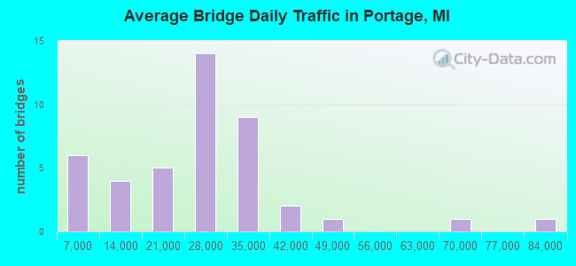
- 1,044,739Total average daily traffic
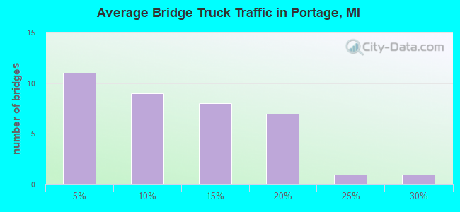
- 113,592Total average daily truck traffic
- National Bridge Inventory (NBI) Registered Bridges for Portage
- No street view available for this location
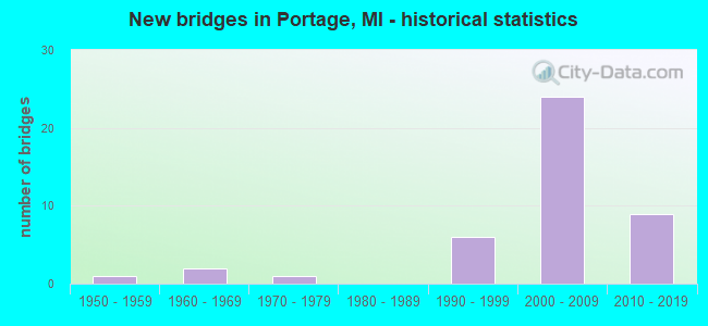
- New bridges - historical statistics
- 11950-1959
- 21960-1969
- 11970-1979
- 61990-1999
- 242000-2009
- 92010-2019
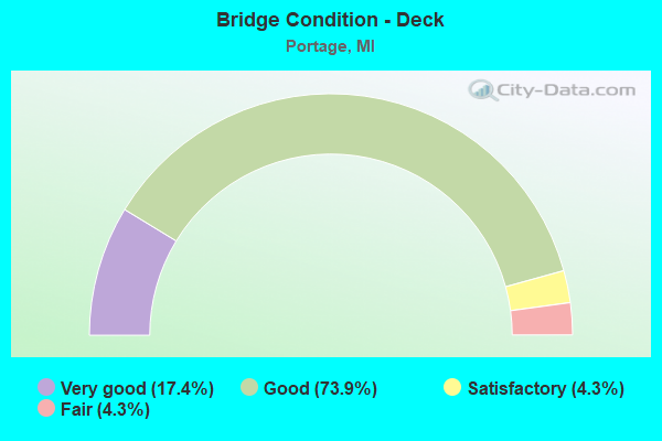
- Bridge Condition - Deck
- 17.4%Very good
- 73.9%Good
- 4.3%Satisfactory
- 4.3%Fair
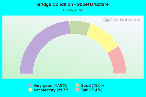
- Bridge Condition - Superstructure
- 47.8%Very good
- 13.0%Good
- 21.7%Satisfactory
- 17.4%Fair
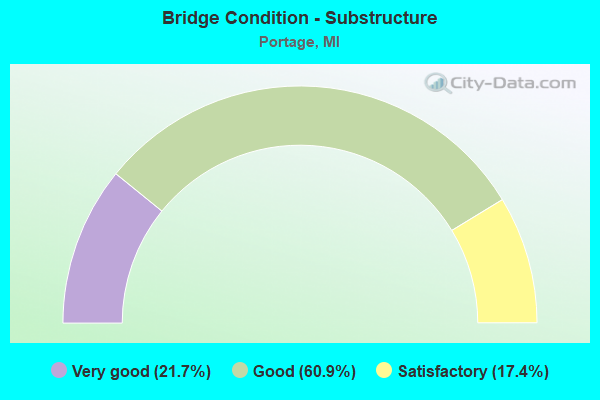
- Bridge Condition - Substructure
- 21.7%Very good
- 60.9%Good
- 17.4%Satisfactory
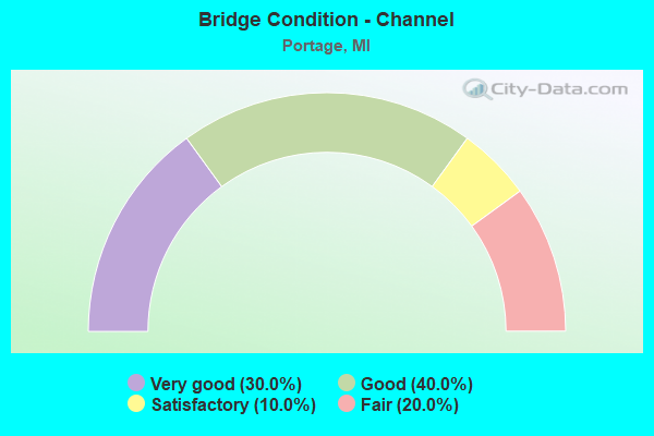
- Bridge Condition - Channel
- 30.0%Very good
- 40.0%Good
- 10.0%Satisfactory
- 20.0%Fair
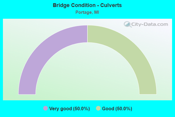
- Bridge Condition - Culverts
- 50.0%Very good
- 50.0%Good
Find on map >> Show street view
Structure Number: 469, Location: 0.1 MI EAST OF CITY LIMIT (Lat: 43.953639, Lng: -83.944058), Route carried "on" structure: County highway , Year Built: 1972, Status: Posted for load, Structure Length: 2.37m (7.78ft), Average Daily Traffic: 1,960 (year 2019), Truck Traffic: 5%, Average Future Daily Traffic: 3,000 (year 2039), Design Load: HS 20+Mod, Features Intersected: S BRANCH PINE RIVER, Facility Carried by Structure: SAGATOO ROAD
Minimum Vertical Clearance: 30.48m (100.00ft), Kilometerpoint: 5.639, Lanes on structure: 2, Owner: County Highway Agency, Approaching Roadway Width: 9.1m (29.9ft), Material/Design: Wood or Timber, Design/Construction: Slab, Number Of Spans In Main Unit: 3, Length of Maximum Span: 7.9m (25.9ft), Curb-To-Curb Width: 9.1m (29.9ft), Out-to-Out Width: 9.7m (31.8ft)
Condition: Deck: Fair, Superstructure: Fair, Substructure: Satisfactory, Channel: Good, Operating Rating: 23.0 metric tons, Method Used To Determine Operating Rating: Allowable Stress (AS) rating reported by rating factor (RF) method using MS18 loading, Inventory Rating: 16.2 metric tons, Method Used To Determine Inventory Rating: Allowable Stress (AS) rating reported by rating factor (RF) method using MS18 loading, Structural Evaluation: Meets minimum limits, Deck Geometry: Somewhat better than minimum adequacy, Waterway Adequacy: Superior to present desirable criteria, Approach Roadway Alignment: Equal to present minimum criteria, Bridge Posting: Required (Relationship of Operating Rating to Maximum Legal Load: > 39.9% below), Designated Inspection Frequency: Every 12 months, Inspection Date: August 2021, Deck Structure Type: Wood or Timber, Wearing Surface/Protective System: Wearing Surface: Bituminous
Find on map >> Show street view
Structure Number: 4552, Location: 2.8 MI S OF I-94 (Lat: 42.199483, Lng: -85.645497), Route carried "on" structure: County highway 2005, Year Built: 1963, Year Reconstructed: 1997, Status: Open, Structure Length: 6.69m (21.95ft), Average Daily Traffic: 17,883 (year 1995), Truck Traffic: 20%, Average Future Daily Traffic: 25,900 (year 2015), Design Load: HS 20, Features Intersected: US-131, Facility Carried by Structure: CENTRE AVE (Q AVE)
Minimum Vertical Clearance: 30.48m (100.00ft), Kilometerpoint: 10.067, Lanes on structure: 5, Lanes under structure: 4, Base Highway Network: Yes (Inventory Route: 2, Subroute: 4), Owner: State Highway Agency, Approaching Roadway Width: 21.9m (71.9ft), Skew: 1 degrees, Material/Design: Prestressed concrete, Design/Construction: Stringer/Multi-beam, Number Of Spans In Main Unit: 4, Length of Maximum Span: 21.8m (71.5ft), Curb or Sidewalk Widths: Left: 0.0m, Right: 2.4m (7.9ft), Curb-To-Curb Width: 24.0m (78.7ft), Out-to-Out Width: 25.0m (82.0ft)
Condition: Deck: Satisfactory, Superstructure: Fair, Substructure: Satisfactory, Operating Rating: 59.0 metric tons, Method Used To Determine Operating Rating: Load Factor (LF) rating reported by rating factor (RF) method using MS18 loading, Inventory Rating: 31.8 metric tons, Method Used To Determine Inventory Rating: Load Factor (LF) rating reported by rating factor (RF) method using MS18 loading, Structural Evaluation: Somewhat better than minimum adequacy, Deck Geometry: Equal to present desirable criteria, Underclear: Meets minimum limits, Approach Roadway Alignment: Equal to present desirable criteria, Designated Inspection Frequency: Every 24 months, Inspection Date: August 2020, Deck Structure Type: Concrete Cast-file-Place, Wearing Surface/Protective System: Wearing Surface: Monolithic Concrete, Deck Protection: Epoxy Coated Reinforcing
Find on map >> Show street view
Structure Number: 4553, Location: 0.6 MI S OF I-94 (Lat: 42.230275, Lng: -85.638550), Route carried "on" structure: City street , Year Built: 1999, Status: Open, Structure Length: 6.43m (21.10ft), Average Daily Traffic: 8,900 (year 1998), Truck Traffic: 3%, Average Future Daily Traffic: 16,100 (year 2018), Design Load: HS 25 or greater, Features Intersected: US-131, Facility Carried by Structure: MILHAM RD (O AVE)
Minimum Vertical Clearance: 30.48m (100.00ft), Kilometerpoint: 0.798, Lanes on structure: 3, Lanes under structure: 4, Owner: State Highway Agency, Approaching Roadway Width: 12.3m (40.4ft), Skew: 1 degrees, Material/Design: Prestressed concrete, Design/Construction: Box Beam or Girders - Single/Spread, Number Of Spans In Main Unit: 4, Length of Maximum Span: 22.2m (72.8ft), Curb or Sidewalk Widths: Left: 1.5m (4.9ft), Right: 1.5m (4.9ft), Curb-To-Curb Width: 13.8m (45.3ft), Out-to-Out Width: 17.8m (58.4ft)
Condition: Deck: Good, Superstructure: Fair, Substructure: Satisfactory, Operating Rating: 87.8 metric tons, Method Used To Determine Operating Rating: Load Factor (LF) rating reported by rating factor (RF) method using MS18 loading, Inventory Rating: 42.4 metric tons, Method Used To Determine Inventory Rating: Load Factor (LF) rating reported by rating factor (RF) method using MS18 loading, Structural Evaluation: Somewhat better than minimum adequacy, Deck Geometry: Somewhat better than minimum adequacy, Underclear: Somewhat better than minimum adequacy, Approach Roadway Alignment: Equal to present minimum criteria, Designated Inspection Frequency: Every 24 months, Inspection Date: August 2020, Deck Structure Type: Concrete Cast-file-Place, Wearing Surface/Protective System: Wearing Surface: Monolithic Concrete, Deck Protection: Epoxy Coated Reinforcing
Find on map >> Show street view
Structure Number: 4571, Location: 3.0 MI E OF US-131 (Lat: 42.237236, Lng: -85.579289), Route carried "on" structure: Interstate 94, Year Built: 2009, Status: Open, Structure Length: 6.63m (21.75ft), Average Daily Traffic: 34,630 (year 2007), Truck Traffic: 17%, Average Future Daily Traffic: 42,465 (year 2025), Design Load: HS 25 or greater, Features Intersected: GRAND ELK RR&PORTAGE CRK
Minimum Vertical Clearance: 30.48m (100.00ft), Kilometerpoint: 15.735, Lanes on structure: 3, Base Highway Network: Yes (Inventory Route: 1, Subroute: 3), Owner: State Highway Agency, Approaching Roadway Width: 19.5m (64.0ft), Skew: 1 degrees, Material/Design: Prestressed concrete, Design/Construction: Box Beam or Girders - Multiple, Number Of Spans In Main Unit: 2, Length of Maximum Span: 33.1m (108.6ft), Curb-To-Curb Width: 19.5m (64.0ft), Out-to-Out Width: 20.5m (67.3ft)
Condition: Deck: Good, Superstructure: Satisfactory, Substructure: Good, Channel: Fair, Operating Rating: 92.6 metric tons, Method Used To Determine Operating Rating: Load Factor (LF), Inventory Rating: 46.3 metric tons, Method Used To Determine Inventory Rating: Load Factor (LF), Structural Evaluation: Equal to present minimum criteria, Deck Geometry: Superior to present desirable criteria, Underclear: Equal to present desirable criteria, Waterway Adequacy: Better than present minimum criteria, Approach Roadway Alignment: Better than present minimum criteria, Designated Inspection Frequency: Every 24 months, Inspection Date: September 2020, Deck Structure Type: Concrete Cast-file-Place, Wearing Surface/Protective System: Wearing Surface: Monolithic Concrete, Deck Protection: Epoxy Coated Reinforcing
Find on map >> Show street view
Structure Number: 4574, Location: 3.0 MI E OF US-131 (Lat: 42.237581, Lng: -85.579281), Route carried "on" structure: Interstate 94, Year Built: 2011, Status: Open, Structure Length: 6.63m (21.75ft), Average Daily Traffic: 34,630 (year 2007), Truck Traffic: 17%, Average Future Daily Traffic: 42,465 (year 2025), Design Load: HS 25 or greater, Features Intersected: GRAND ELK RR&PORTAGE CRK
Minimum Vertical Clearance: 30.48m (100.00ft), Kilometerpoint: 15.738, Lanes on structure: 3, Base Highway Network: Yes (Inventory Route: 2, Subroute: 5), Owner: State Highway Agency, Approaching Roadway Width: 19.5m (64.0ft), Skew: 1 degrees, Material/Design: Prestressed concrete, Design/Construction: Box Beam or Girders - Multiple, Number Of Spans In Main Unit: 2, Length of Maximum Span: 33.1m (108.6ft), Curb-To-Curb Width: 19.5m (64.0ft), Out-to-Out Width: 20.5m (67.3ft)
Condition: Deck: Good, Superstructure: Very good, Substructure: Good, Channel: Fair, Operating Rating: 93.1 metric tons, Method Used To Determine Operating Rating: Load Factor (LF), Inventory Rating: 46.4 metric tons, Method Used To Determine Inventory Rating: Load Factor (LF), Structural Evaluation: Better than present minimum criteria, Deck Geometry: Superior to present desirable criteria, Underclear: Equal to present desirable criteria, Waterway Adequacy: Better than present minimum criteria, Approach Roadway Alignment: Equal to present desirable criteria, Designated Inspection Frequency: Every 24 months, Inspection Date: September 2020, Deck Structure Type: Concrete Cast-file-Place, Wearing Surface/Protective System: Wearing Surface: Monolithic Concrete, Deck Protection: Epoxy Coated Reinforcing
Find on map >> Show street view
Structure Number: 4575, Location: 2.4 MI E OF US-131 (Lat: 42.236753, Lng: -85.589533), Route carried "on" structure: Interstate 94, Year Built: 2010, Status: Open, Structure Length: 7.85m (25.75ft), Average Daily Traffic: 30,000 (year 2007), Truck Traffic: 17%, Average Future Daily Traffic: 35,080 (year 2025), Design Load: HS 25 or greater, Features Intersected: S WESTNEDGE AVE
Minimum Vertical Clearance: 30.48m (100.00ft), Kilometerpoint: 14.903, Lanes on structure: 3, Lanes under structure: 6, Base Highway Network: Yes (Inventory Route: 1, Subroute: 3), Owner: State Highway Agency, Approaching Roadway Width: 19.5m (64.0ft), Material/Design: Steel, Design/Construction: Box Beam or Girders - Single/Spread, Number Of Spans In Main Unit: 1, Length of Maximum Span: 77.7m (254.9ft), Curb-To-Curb Width: 19.5m (64.0ft), Out-to-Out Width: 20.5m (67.3ft)
Condition: Deck: Good, Superstructure: Good, Substructure: Good, Operating Rating: 97.2 metric tons, Method Used To Determine Operating Rating: Load Factor (LF) rating reported by rating factor (RF) method using MS18 loading, Inventory Rating: 75.5 metric tons, Method Used To Determine Inventory Rating: Load Factor (LF) rating reported by rating factor (RF) method using MS18 loading, Structural Evaluation: Better than present minimum criteria, Deck Geometry: Superior to present desirable criteria, Underclear: Somewhat better than minimum adequacy, Approach Roadway Alignment: Equal to present desirable criteria, Designated Inspection Frequency: Every 24 months, Inspection Date: September 2020, Deck Structure Type: Concrete Cast-file-Place, Wearing Surface/Protective System: Wearing Surface: Monolithic Concrete, Deck Protection: Epoxy Coated Reinforcing
Find on map >> Show street view
Structure Number: 4576, Location: 2.4 MI E OF US-131 (Lat: 42.236944, Lng: -85.589528), Route carried "on" structure: Interstate 94, Year Built: 2011, Status: Open, Structure Length: 7.85m (25.75ft), Average Daily Traffic: 30,000 (year 2007), Truck Traffic: 17%, Average Future Daily Traffic: 35,080 (year 2025), Design Load: HS 25 or greater, Features Intersected: S WESTNEDGE AVE
Minimum Vertical Clearance: 30.48m (100.00ft), Kilometerpoint: 14.906, Lanes on structure: 3, Lanes under structure: 6, Base Highway Network: Yes (Inventory Route: 2, Subroute: 5), Owner: State Highway Agency, Approaching Roadway Width: 19.5m (64.0ft), Skew: 10 degrees, Material/Design: Steel, Design/Construction: Box Beam or Girders - Single/Spread, Number Of Spans In Main Unit: 1, Length of Maximum Span: 77.7m (254.9ft), Curb-To-Curb Width: 19.5m (64.0ft), Out-to-Out Width: 20.5m (67.3ft)
Condition: Deck: Good, Superstructure: Good, Substructure: Good, Operating Rating: 97.2 metric tons, Method Used To Determine Operating Rating: Load Factor (LF) rating reported by rating factor (RF) method using MS18 loading, Inventory Rating: 75.5 metric tons, Method Used To Determine Inventory Rating: Load Factor (LF) rating reported by rating factor (RF) method using MS18 loading, Structural Evaluation: Better than present minimum criteria, Deck Geometry: Superior to present desirable criteria, Underclear: Somewhat better than minimum adequacy, Approach Roadway Alignment: Equal to present desirable criteria, Designated Inspection Frequency: Every 24 months, Inspection Date: September 2020, Deck Structure Type: Concrete Cast-file-Place, Wearing Surface/Protective System: Wearing Surface: Monolithic Concrete, Deck Protection: Epoxy Coated Reinforcing
Find on map >> Show street view
Structure Number: 4577, Location: 3.2 MI E OF US-131 (Lat: 42.238761, Lng: -85.574847), Route carried "on" structure: City street 2005, Year Built: 2006, Status: Open, Structure Length: 5.38m (17.65ft), Average Daily Traffic: 11,767 (year 1995), Truck Traffic: 4%, Average Future Daily Traffic: 28,500 (year 2025), Design Load: HS 25 or greater, Features Intersected: I-94, Facility Carried by Structure: LOVERS LANE
Minimum Vertical Clearance: 30.48m (100.00ft), Kilometerpoint: 5.121, Lanes on structure: 5, Lanes under structure: 5, Owner: State Highway Agency, Approaching Roadway Width: 20.4m (66.9ft), Skew: 2 degrees, Material/Design: Prestressed concrete, Design/Construction: Box Beam or Girders - Multiple, Number Of Spans In Main Unit: 2, Length of Maximum Span: 26.9m (88.3ft), Curb or Sidewalk Widths: Left: 1.7m (5.6ft), Right: 1.7m (5.6ft), Curb-To-Curb Width: 20.4m (66.9ft), Out-to-Out Width: 24.5m (80.4ft)
Condition: Deck: Good, Superstructure: Satisfactory, Substructure: Good, Operating Rating: 89.1 metric tons, Method Used To Determine Operating Rating: Load Factor (LF) rating reported by rating factor (RF) method using MS18 loading, Inventory Rating: 43.1 metric tons, Method Used To Determine Inventory Rating: Load Factor (LF) rating reported by rating factor (RF) method using MS18 loading, Structural Evaluation: Equal to present minimum criteria, Deck Geometry: Somewhat better than minimum adequacy, Underclear: Equal to present minimum criteria, Approach Roadway Alignment: Better than present minimum criteria, Designated Inspection Frequency: Every 24 months, Inspection Date: September 2020, Deck Structure Type: Concrete Cast-file-Place, Wearing Surface/Protective System: Wearing Surface: Monolithic Concrete, Deck Protection: Epoxy Coated Reinforcing
Find on map >> Show street view
Structure Number: 459, Location: 4.8 MI E OF VAN BUREN COL (Lat: 42.237539, Lng: -85.677503), Route carried "on" structure: County highway 2005, Year Built: 1996, Status: Open, Structure Length: 8.23m (27.00ft), Average Daily Traffic: 24,675 (year 2018), Truck Traffic: 8%, Average Future Daily Traffic: 27,250 (year 2038), Design Load: HS 25 or greater, Features Intersected: I-94, Facility Carried by Structure: 9 TH STREET
Minimum Vertical Clearance: 30.48m (100.00ft), Kilometerpoint: 0.821, Lanes on structure: 5, Lanes under structure: 4, Owner: State Highway Agency, Approaching Roadway Width: 21.2m (69.6ft), Material/Design: Prestressed concrete, Design/Construction: Stringer/Multi-beam, Number Of Spans In Main Unit: 4, Length of Maximum Span: 31.7m (104.0ft), Curb or Sidewalk Widths: Left: 0.0m, Right: 3.0m (9.8ft), Curb-To-Curb Width: 21.2m (69.6ft), Out-to-Out Width: 25.4m (83.3ft)
Condition: Deck: Good, Superstructure: Fair, Substructure: Satisfactory, Operating Rating: 43.1 metric tons, Method Used To Determine Operating Rating: Load and Resistance Factor Rating (LRFR) rating reported by rating factor(RF) method using HL-93 loadings, Inventory Rating: 33.0 metric tons, Method Used To Determine Inventory Rating: Load and Resistance Factor Rating (LRFR) rating reported by rating factor(RF) method using HL-93 loadings, Structural Evaluation: Somewhat better than minimum adequacy, Deck Geometry: Somewhat better than minimum adequacy, Underclear: Equal to present minimum criteria, Approach Roadway Alignment: Better than present minimum criteria, Designated Inspection Frequency: Every 24 months, Inspection Date: September 2020, Deck Structure Type: Concrete Cast-file-Place, Wearing Surface/Protective System: Wearing Surface: Epoxy Overlay, Deck Protection: Epoxy Coated Reinforcing
Find on map >> Show street view
Structure Number: 4593, Location: AT US-131 SB (Lat: 42.237803, Lng: -85.638511), Route carried "on" structure: Interstate 94, Year Built: 2008, Status: Open, Structure Length: 2.98m (9.78ft), Average Daily Traffic: 19,866 (year 2007), Truck Traffic: 14%, Average Future Daily Traffic: 53,855 (year 2025), Design Load: HS 25 or greater, Features Intersected: US-131 SB
Minimum Vertical Clearance: 30.48m (100.00ft), Kilometerpoint: 10.870, Lanes on structure: 4, Lanes under structure: 3, Base Highway Network: Yes (Inventory Route: 1, Subroute: 3), Owner: State Highway Agency, Approaching Roadway Width: 22.8m (74.8ft), Material/Design: Prestressed concrete, Design/Construction: Stringer/Multi-beam, Number Of Spans In Main Unit: 1, Length of Maximum Span: 29.4m (96.5ft), Curb-To-Curb Width: 23.2m (76.1ft), Out-to-Out Width: 24.1m (79.1ft)
Condition: Deck: Good, Superstructure: Very good, Substructure: Good, Operating Rating: 69.7 metric tons, Method Used To Determine Operating Rating: Load Factor (LF), Inventory Rating: 32.4 metric tons, Method Used To Determine Inventory Rating: Load Factor (LF), Structural Evaluation: Better than present minimum criteria, Deck Geometry: Superior to present desirable criteria, Underclear: Better than present minimum criteria, Approach Roadway Alignment: Equal to present desirable criteria, Designated Inspection Frequency: Every 24 months, Inspection Date: July 2020, Deck Structure Type: Concrete Cast-file-Place, Wearing Surface/Protective System: Wearing Surface: Integral Concrete, Deck Protection: Epoxy Coated Reinforcing
Find on map >> Show street view
Structure Number: 4594, Location: AT US-131 SB (Lat: 42.238164, Lng: -85.638572), Route carried "on" structure: Interstate 94, Year Built: 2007, Status: Open, Structure Length: 2.99m (9.81ft), Average Daily Traffic: 19,866 (year 2007), Truck Traffic: 14%, Average Future Daily Traffic: 53,855 (year 2025), Design Load: HS 25 or greater, Features Intersected: US-131 SB
Minimum Vertical Clearance: 30.48m (100.00ft), Kilometerpoint: 10.867, Lanes on structure: 4, Lanes under structure: 3, Base Highway Network: Yes (Inventory Route: 2, Subroute: 5), Owner: State Highway Agency, Approaching Roadway Width: 18.2m (59.7ft), Material/Design: Prestressed concrete, Design/Construction: Stringer/Multi-beam, Number Of Spans In Main Unit: 1, Length of Maximum Span: 29.4m (96.5ft), Curb-To-Curb Width: 23.0m (75.5ft), Out-to-Out Width: 24.1m (79.1ft)
Condition: Deck: Good, Superstructure: Very good, Substructure: Good, Operating Rating: 69.7 metric tons, Method Used To Determine Operating Rating: Load Factor (LF), Inventory Rating: 32.4 metric tons, Method Used To Determine Inventory Rating: Load Factor (LF), Structural Evaluation: Better than present minimum criteria, Deck Geometry: Superior to present desirable criteria, Underclear: Better than present minimum criteria, Approach Roadway Alignment: Equal to present desirable criteria, Designated Inspection Frequency: Every 24 months, Inspection Date: July 2020, Deck Structure Type: Concrete Cast-file-Place, Wearing Surface/Protective System: Wearing Surface: Integral Concrete, Deck Protection: Epoxy Coated Reinforcing
Find on map >> Show street view
Structure Number: 4595, Location: AT US-131 NB (Lat: 42.237803, Lng: -85.637375), Route carried "on" structure: Interstate 94, Year Built: 2008, Status: Open, Structure Length: 2.97m (9.74ft), Average Daily Traffic: 39,044 (year 2007), Truck Traffic: 14%, Average Future Daily Traffic: 47,921 (year 2018), Design Load: HS 25 or greater, Features Intersected: US-131 NB
Minimum Vertical Clearance: 30.48m (100.00ft), Kilometerpoint: 10.963, Lanes on structure: 4, Lanes under structure: 3, Base Highway Network: Yes (Inventory Route: 1, Subroute: 3), Owner: State Highway Agency, Approaching Roadway Width: 22.8m (74.8ft), Material/Design: Prestressed concrete, Design/Construction: Stringer/Multi-beam, Number Of Spans In Main Unit: 1, Length of Maximum Span: 28.3m (92.8ft), Curb-To-Curb Width: 24.1m (79.1ft), Out-to-Out Width: 25.1m (82.3ft)
Condition: Deck: Good, Superstructure: Good, Substructure: Good, Operating Rating: 91.7 metric tons, Method Used To Determine Operating Rating: Load Factor (LF) rating reported by rating factor (RF) method using MS18 loading, Inventory Rating: 34.0 metric tons, Method Used To Determine Inventory Rating: Load Factor (LF) rating reported by rating factor (RF) method using MS18 loading, Structural Evaluation: Better than present minimum criteria, Deck Geometry: Superior to present desirable criteria, Underclear: Better than present minimum criteria, Approach Roadway Alignment: Equal to present desirable criteria, Designated Inspection Frequency: Every 24 months, Inspection Date: July 2020, Deck Structure Type: Concrete Cast-file-Place, Wearing Surface/Protective System: Wearing Surface: Integral Concrete, Deck Protection: Epoxy Coated Reinforcing
Find on map >> Show street view
Structure Number: 4596, Location: AT US-131 NB (Lat: 42.238164, Lng: -85.637397), Route carried "on" structure: Interstate 94, Year Built: 2007, Status: Open, Structure Length: 2.97m (9.74ft), Average Daily Traffic: 39,044 (year 2007), Truck Traffic: 14%, Average Future Daily Traffic: 47,921 (year 2018), Design Load: HS 25 or greater, Features Intersected: US-131 NB
Minimum Vertical Clearance: 30.48m (100.00ft), Kilometerpoint: 10.963, Lanes on structure: 4, Lanes under structure: 3, Base Highway Network: Yes (Inventory Route: 2, Subroute: 5), Owner: State Highway Agency, Approaching Roadway Width: 18.2m (59.7ft), Material/Design: Prestressed concrete, Design/Construction: Stringer/Multi-beam, Number Of Spans In Main Unit: 1, Length of Maximum Span: 28.3m (92.8ft), Curb-To-Curb Width: 23.2m (76.1ft), Out-to-Out Width: 24.1m (79.1ft)
Condition: Deck: Good, Superstructure: Very good, Substructure: Good, Operating Rating: 95.3 metric tons, Method Used To Determine Operating Rating: Load Factor (LF) rating reported by rating factor (RF) method using MS18 loading, Inventory Rating: 35.3 metric tons, Method Used To Determine Inventory Rating: Load Factor (LF) rating reported by rating factor (RF) method using MS18 loading, Structural Evaluation: Better than present minimum criteria, Deck Geometry: Superior to present desirable criteria, Underclear: Better than present minimum criteria, Approach Roadway Alignment: Equal to present desirable criteria, Designated Inspection Frequency: Every 24 months, Inspection Date: July 2020, Deck Structure Type: Concrete Cast-file-Place, Wearing Surface/Protective System: Wearing Surface: Integral Concrete, Deck Protection: Epoxy Coated Reinforcing
Find on map >> Show street view
Structure Number: 4597, Location: 1.2 MI E OF US-131 (Lat: 42.237989, Lng: -85.614053), Route carried "on" structure: City street 2005, Year Built: 2007, Status: Open, Structure Length: 4.82m (15.81ft), Average Daily Traffic: 25,000 (year 2005), Truck Traffic: 4%, Average Future Daily Traffic: 28,335 (year 2025), Design Load: HS 25 or greater, Features Intersected: I-94, Facility Carried by Structure: OAKLAND DRIVE
Minimum Vertical Clearance: 30.48m (100.00ft), Kilometerpoint: 7.258, Lanes on structure: 6, Lanes under structure: 6, Base Highway Network: Yes (Inventory Route: 339, Subroute: 65), Owner: State Highway Agency, Approaching Roadway Width: 14.3m (46.9ft), Material/Design: Prestressed concrete, Design/Construction: Box Beam or Girders - Multiple, Number Of Spans In Main Unit: 2, Length of Maximum Span: 24.1m (79.1ft), Curb or Sidewalk Widths: Left: 2.0m (6.6ft), Right: 2.0m (6.6ft), Curb-To-Curb Width: 23.8m (78.1ft), Out-to-Out Width: 28.5m (93.5ft)
Condition: Deck: Good, Superstructure: Satisfactory, Substructure: Good, Operating Rating: 82.6 metric tons, Method Used To Determine Operating Rating: Load Factor (LF) rating reported by rating factor (RF) method using MS18 loading, Inventory Rating: 49.6 metric tons, Method Used To Determine Inventory Rating: Load Factor (LF) rating reported by rating factor (RF) method using MS18 loading, Structural Evaluation: Equal to present minimum criteria, Deck Geometry: Somewhat better than minimum adequacy, Underclear: Somewhat better than minimum adequacy, Approach Roadway Alignment: Equal to present desirable criteria, Designated Inspection Frequency: Every 24 months, Inspection Date: July 2020, Deck Structure Type: Concrete Cast-file-Place, Wearing Surface/Protective System: Wearing Surface: Integral Concrete, Deck Protection: Epoxy Coated Reinforcing
Find on map >> Show street view
Structure Number: 4627, Location: 0.8 MI N OF INDIAN LAKE (Lat: 42.172258, Lng: -85.471883), Route carried "on" structure: County highway , Year Built: 2017, Status: Open, Structure Length: 1.40m (4.59ft), Average Daily Traffic: 1,259 (year 2016), Truck Traffic: 5%, Average Future Daily Traffic: 1,462 (year 2056), Features Intersected: PORTAGE RIVER, Facility Carried by Structure: S AVENUE
Minimum Vertical Clearance: 30.48m (100.00ft), Kilometerpoint: 5.403, Lanes on structure: 2, Owner: County Highway Agency, Approaching Roadway Width: 9.1m (29.9ft), Material/Design: Steel, Design/Construction: Stringer/Multi-beam, Number Of Spans In Main Unit: 1, Length of Maximum Span: 12.5m (41.0ft), Curb-To-Curb Width: 9.8m (32.2ft), Out-to-Out Width: 10.5m (34.4ft)
Condition: Deck: Very good, Superstructure: Very good, Substructure: Very good, Channel: Good, Operating Rating: 97.2 metric tons, Method Used To Determine Operating Rating: Load and Resistance Factor Rating (LRFR) rating reported by rating factor(RF) method using HL-93 loadings, Inventory Rating: 89.7 metric tons, Method Used To Determine Inventory Rating: Load and Resistance Factor Rating (LRFR) rating reported by rating factor(RF) method using HL-93 loadings, Structural Evaluation: Equal to present desirable criteria, Deck Geometry: Somewhat better than minimum adequacy, Waterway Adequacy: Better than present minimum criteria, Approach Roadway Alignment: Equal to present desirable criteria, Designated Inspection Frequency: Every 24 months, Inspection Date: September 2021, Deck Structure Type: Concrete Cast-file-Place, Wearing Surface/Protective System: Deck Protection: Epoxy Coated Reinforcing
Find on map >> Show street view
Structure Number: 4634, Location: 0.4MI S/PORTAGE CITYLIMIT (Lat: 42.152647, Lng: -85.569558), Route carried "on" structure: County highway 3943, Year Built: 2006, Status: Open, Structure Length: 1.20m (3.94ft), Average Daily Traffic: 11,685 (year 2019), Truck Traffic: 3%, Average Future Daily Traffic: 15,738 (year 2039), Design Load: HS 20, Features Intersected: GOURD NECK CREEK, Facility Carried by Structure: PORTAGE ROAD
Minimum Vertical Clearance: 30.48m (100.00ft), Kilometerpoint: 8.116, Lanes on structure: 2, Owner: County Highway Agency, Approaching Roadway Width: 12.8m (42.0ft), Material/Design: Prestressed concrete, Design/Construction: Box Beam or Girders - Multiple, Number Of Spans In Main Unit: 1, Length of Maximum Span: 11.0m (36.1ft), Curb-To-Curb Width: 12.4m (40.7ft), Out-to-Out Width: 13.4m (44.0ft)
Condition: Deck: Good, Superstructure: Very good, Substructure: Very good, Channel: Very good, Operating Rating: 59.9 metric tons, Method Used To Determine Operating Rating: Load Factor (LF), Inventory Rating: 35.9 metric tons, Method Used To Determine Inventory Rating: Load Factor (LF), Structural Evaluation: Equal to present desirable criteria, Deck Geometry: Somewhat better than minimum adequacy, Waterway Adequacy: Equal to present desirable criteria, Approach Roadway Alignment: Equal to present desirable criteria, Designated Inspection Frequency: Every 24 months, Inspection Date: October 2020, Deck Structure Type: Concrete Cast-file-Place, Wearing Surface/Protective System: Wearing Surface: Epoxy Overlay, Deck Protection: Epoxy Coated Reinforcing
Find on map >> Show street view
Structure Number: 4688, Location: IN PORTAGE TWP SEC 10-15 (Lat: 42.215544, Lng: -85.581967), Route carried "on" structure: City street , Year Built: 1992, Status: Open, Structure Length: 2.43m (7.97ft), Average Daily Traffic: 10,000 (year 1993), Truck Traffic: 2%, Average Future Daily Traffic: 20,000 (year 2015), Design Load: HS 20, Features Intersected: PORTAGE CREEK, Facility Carried by Structure: ROMENCE ROAD
Minimum Vertical Clearance: 30.48m (100.00ft), Kilometerpoint: 0.599, Lanes on structure: 4, Base Highway Network: Yes (Inventory Route: 339, Subroute: 74), Owner: City or Municipal Highway Agency, Approaching Roadway Width: 14.9m (48.9ft), Material/Design: Concrete continuous, Design/Construction: Box Beam or Girders - Multiple, Number Of Spans In Main Unit: 2, Length of Maximum Span: 16.4m (53.8ft), Curb or Sidewalk Widths: Left: 0.0m, Right: 3.0m (9.8ft), Curb-To-Curb Width: 14.9m (48.9ft), Out-to-Out Width: 18.6m (61.0ft)
Condition: Deck: Very good, Superstructure: Very good, Substructure: Very good, Channel: Very good, Operating Rating: 59.1 metric tons, Method Used To Determine Operating Rating: Allowable Stress (AS), Inventory Rating: 38.2 metric tons, Method Used To Determine Inventory Rating: Allowable Stress (AS), Structural Evaluation: Equal to present desirable criteria, Deck Geometry: High priority of replacement, Waterway Adequacy: Superior to present desirable criteria, Approach Roadway Alignment: Superior to present desirable criteria, Designated Inspection Frequency: Every 24 months, Inspection Date: September 2021, Deck Structure Type: Concrete Cast-file-Place, Wearing Surface/Protective System: Wearing Surface: Monolithic Concrete
Find on map >> Show street view
Structure Number: 4689, Location: SEC 3-10, PORTAGE TWP (Lat: 42.230139, Lng: -85.576578), Route carried "on" structure: City street , Year Built: 1990, Status: Posted for load, Structure Length: 0.66m (2.17ft), Average Daily Traffic: 18,009 (year 1988), Truck Traffic: 4%, Average Future Daily Traffic: 16,000 (year 2010), Design Load: HS 20+Mod, Features Intersected: PORTAGE CREEK, Facility Carried by Structure: MILHAM AVE
Minimum Vertical Clearance: 30.48m (100.00ft), Kilometerpoint: 5.915, Lanes on structure: 4, Owner: City or Municipal Highway Agency, Approaching Roadway Width: 13.4m (44.0ft), Material/Design: Concrete, Design/Construction: Culvert, Number Of Spans In Main Unit: 1, Length of Maximum Span: 6.1m (20.0ft), Curb or Sidewalk Widths: Left: 1.7m (5.6ft), Right: 1.7m (5.6ft), Curb-To-Curb Width: 14.3m (46.9ft), Out-to-Out Width: 18.6m (61.0ft)
Condition: Channel: Very good, Culverts: Good, Operating Rating: 32.7 metric tons, Method Used To Determine Operating Rating: Load Factor (LF), Inventory Rating: 19.6 metric tons, Method Used To Determine Inventory Rating: Load Factor (LF), Structural Evaluation: Meets minimum limits, Deck Geometry: High priority of replacement, Waterway Adequacy: Superior to present desirable criteria, Approach Roadway Alignment: Equal to present desirable criteria, Bridge Posting: Required (Relationship of Operating Rating to Maximum Legal Load: 0.1 - 9.9% below), Designated Inspection Frequency: Every 24 months, Inspection Date: September 2021, Wearing Surface/Protective System: Wearing Surface: Bituminous
Find on map >> Show street view
Structure Number: 469, Location: SEC 3-10 PORTAGE TWP (Lat: 42.245067, Lng: -85.576067), Route carried "on" structure: City street , Year Built: 2013, Status: Open, Structure Length: 0.84m (2.76ft), Average Daily Traffic: 15,000 (year 2013), Truck Traffic: 8%, Average Future Daily Traffic: 21,000 (year 2033), Design Load: Greater than HL93, Features Intersected: PORTAGE CREEK, Facility Carried by Structure: KILGORE ROAD
Minimum Vertical Clearance: 30.48m (100.00ft), Kilometerpoint: 3.129, Lanes on structure: 4, Owner: City or Municipal Highway Agency, Approaching Roadway Width: 14.6m (47.9ft), Skew: 2 degrees, Material/Design: Concrete, Design/Construction: Culvert, Number Of Spans In Main Unit: 1, Length of Maximum Span: 7.8m (25.6ft), Curb or Sidewalk Widths: Left: 2.4m (7.9ft), Right: 3.7m (12.1ft), Curb-To-Curb Width: 14.6m (47.9ft), Out-to-Out Width: 26.9m (88.3ft)
Condition: Channel: Good, Culverts: Very good, Operating Rating: 42.1 metric tons, Method Used To Determine Operating Rating: Load and Resistance Factor Rating (LRFR) rating reported by rating factor(RF) method using HL-93 loadings, Inventory Rating: 32.4 metric tons, Method Used To Determine Inventory Rating: Load and Resistance Factor Rating (LRFR) rating reported by rating factor(RF) method using HL-93 loadings, Structural Evaluation: Equal to present desirable criteria, Deck Geometry: High priority of replacement, Waterway Adequacy: Superior to present desirable criteria, Approach Roadway Alignment: Equal to present desirable criteria, Designated Inspection Frequency: Every 24 months, Inspection Date: September 2021, Wearing Surface/Protective System: Wearing Surface: Bituminous
Find on map >> Show street view
Structure Number: 13296, Location: I-94/US-131 INTERCHANGE (Lat: 42.235767, Lng: -85.638433), Route carried "on" structure: Ramp Interstate 94, Year Built: 2008, Status: Open, Structure Length: 3.08m (10.10ft), Average Daily Traffic: 23,695 (year 2005), Truck Traffic: 12%, Average Future Daily Traffic: 23,695 (year 2025), Design Load: HS 25 or greater, Features Intersected: SB US-131
Minimum Vertical Clearance: 30.48m (100.00ft), Kilometerpoint: 0.586, Lanes on structure: 2, Lanes under structure: 2, Owner: State Highway Agency, Approaching Roadway Width: 15.1m (49.5ft), Skew: 1 degrees, Material/Design: Prestressed concrete, Design/Construction: Stringer/Multi-beam, Number Of Spans In Main Unit: 1, Length of Maximum Span: 29.5m (96.8ft), Curb-To-Curb Width: 15.1m (49.5ft), Out-to-Out Width: 15.9m (52.2ft)
Condition: Deck: Good, Superstructure: Satisfactory, Substructure: Good, Operating Rating: 73.5 metric tons, Method Used To Determine Operating Rating: Load Factor (LF) rating reported by rating factor (RF) method using MS18 loading, Inventory Rating: 30.1 metric tons, Method Used To Determine Inventory Rating: Load Factor (LF) rating reported by rating factor (RF) method using MS18 loading, Structural Evaluation: Equal to present minimum criteria, Deck Geometry: Superior to present desirable criteria, Underclear: Equal to present minimum criteria, Approach Roadway Alignment: Equal to present desirable criteria, Designated Inspection Frequency: Every 24 months, Inspection Date: September 2020, Deck Structure Type: Concrete Cast-file-Place, Wearing Surface/Protective System: Wearing Surface: Monolithic Concrete, Deck Protection: Epoxy Coated Reinforcing
Find on map >> Show street view
Structure Number: 13297, Location: I-94/US-131 INTERCHANGE (Lat: 42.237778, Lng: -85.638889), Route carried "on" structure: Interstate 94, Year Built: 2008, Status: Open, Structure Length: 3.36m (11.02ft), Average Daily Traffic: 23,695 (year 2005), Average Future Daily Traffic: 47,085 (year 2025), Design Load: HS 25 or greater, Features Intersected: US-131SB TO I-94 EB CONN
Minimum Vertical Clearance: 30.48m (100.00ft), Kilometerpoint: 10.674, Lanes on structure: 3, Lanes under structure: 2, Base Highway Network: Yes (Inventory Route: 1, Subroute: 3), Owner: State Highway Agency, Approaching Roadway Width: 19.6m (64.3ft), Skew: 1 degrees, Material/Design: Prestressed concrete, Design/Construction: Stringer/Multi-beam, Number Of Spans In Main Unit: 1, Length of Maximum Span: 32.6m (107.0ft), Curb-To-Curb Width: 21.1m (69.2ft), Out-to-Out Width: 22.0m (72.2ft)
Condition: Deck: Good, Superstructure: Very good, Substructure: Good, Operating Rating: 97.2 metric tons, Method Used To Determine Operating Rating: Load Factor (LF) rating reported by rating factor (RF) method using MS18 loading, Inventory Rating: 41.5 metric tons, Method Used To Determine Inventory Rating: Load Factor (LF) rating reported by rating factor (RF) method using MS18 loading, Structural Evaluation: Better than present minimum criteria, Deck Geometry: Superior to present desirable criteria, Underclear: Superior to present desirable criteria, Approach Roadway Alignment: Equal to present desirable criteria, Designated Inspection Frequency: Every 24 months, Inspection Date: September 2020, Deck Structure Type: Concrete Cast-file-Place, Wearing Surface/Protective System: Wearing Surface: Monolithic Concrete, Deck Protection: Epoxy Coated Reinforcing
Find on map >> Show street view
Structure Number: 13298, Location: I-94/US-131 INTERCHANGE (Lat: 42.238056, Lng: -85.638889), Route carried "on" structure: Interstate 94, Year Built: 2007, Status: Open, Structure Length: 3.36m (11.02ft), Average Daily Traffic: 23,695 (year 2005), Average Future Daily Traffic: 47,085 (year 2025), Design Load: HS 25 or greater, Features Intersected: US-131 SB TO I-94 EB CON
Minimum Vertical Clearance: 30.48m (100.00ft), Kilometerpoint: 10.667, Lanes on structure: 3, Lanes under structure: 2, Base Highway Network: Yes (Inventory Route: 2, Subroute: 5), Owner: State Highway Agency, Approaching Roadway Width: 19.5m (64.0ft), Skew: 1 degrees, Material/Design: Prestressed concrete, Design/Construction: Stringer/Multi-beam, Number Of Spans In Main Unit: 1, Length of Maximum Span: 32.6m (107.0ft), Curb-To-Curb Width: 23.2m (76.1ft), Out-to-Out Width: 24.1m (79.1ft)
Condition: Deck: Good, Superstructure: Very good, Substructure: Good, Operating Rating: 97.2 metric tons, Method Used To Determine Operating Rating: Load Factor (LF) rating reported by rating factor (RF) method using MS18 loading, Inventory Rating: 41.1 metric tons, Method Used To Determine Inventory Rating: Load Factor (LF) rating reported by rating factor (RF) method using MS18 loading, Structural Evaluation: Better than present minimum criteria, Deck Geometry: Superior to present desirable criteria, Underclear: Superior to present desirable criteria, Approach Roadway Alignment: Better than present minimum criteria, Designated Inspection Frequency: Every 24 months, Inspection Date: September 2020, Deck Structure Type: Concrete Cast-file-Place, Wearing Surface/Protective System: Wearing Surface: Monolithic Concrete, Deck Protection: Epoxy Coated Reinforcing
Find on map >> Show street view
Structure Number: 13299, Location: I-94/US-131 INTERCHANGE (Lat: 42.235617, Lng: -85.637633), Route carried "on" structure: Ramp Interstate 94, Year Built: 2008, Status: Open, Structure Length: 2.97m (9.74ft), Average Daily Traffic: 23,695 (year 2005), Truck Traffic: 12%, Average Future Daily Traffic: 23,695 (year 2025), Design Load: HS 25 or greater, Features Intersected: NB US-131
Minimum Vertical Clearance: 30.48m (100.00ft), Kilometerpoint: 0.649, Lanes on structure: 2, Lanes under structure: 2, Owner: State Highway Agency, Approaching Roadway Width: 14.9m (48.9ft), Material/Design: Prestressed concrete, Design/Construction: Stringer/Multi-beam, Number Of Spans In Main Unit: 1, Length of Maximum Span: 29.7m (97.4ft), Curb-To-Curb Width: 14.9m (48.9ft), Out-to-Out Width: 15.9m (52.2ft)
Condition: Deck: Good, Superstructure: Satisfactory, Substructure: Good, Operating Rating: 81.3 metric tons, Method Used To Determine Operating Rating: Load Factor (LF) rating reported by rating factor (RF) method using MS18 loading, Inventory Rating: 25.6 metric tons, Method Used To Determine Inventory Rating: Load Factor (LF) rating reported by rating factor (RF) method using MS18 loading, Structural Evaluation: Equal to present minimum criteria, Deck Geometry: Superior to present desirable criteria, Underclear: Equal to present minimum criteria, Approach Roadway Alignment: Equal to present desirable criteria, Designated Inspection Frequency: Every 24 months, Inspection Date: September 2020, Deck Structure Type: Concrete Cast-file-Place, Wearing Surface/Protective System: Wearing Surface: Monolithic Concrete, Deck Protection: Epoxy Coated Reinforcing
Find on map >> Show street view
Structure Number: 14008, Location: 0.51 MI E OF 29TH STREET (Lat: 42.201300, Lng: -85.471528), Route carried "on" structure: County highway 3944, Year Built: 2017, Status: Open, Structure Length: 1.22m (4.00ft), Average Daily Traffic: 1,079 (year 2016), Truck Traffic: 5%, Average Future Daily Traffic: 1,187 (year 2036), Design Load: Greater than HL93, Features Intersected: PORTAGE RIVER, Facility Carried by Structure: Q AVENUE
Minimum Vertical Clearance: 30.48m (100.00ft), Kilometerpoint: 0.816, Lanes on structure: 2, Owner: County Highway Agency, Approaching Roadway Width: 10.1m (33.1ft), Skew: 1 degrees, Material/Design: Steel, Design/Construction: Stringer/Multi-beam, Number Of Spans In Main Unit: 1, Length of Maximum Span: 11.2m (36.7ft), Curb-To-Curb Width: 9.8m (32.2ft), Out-to-Out Width: 10.5m (34.4ft)
Condition: Deck: Very good, Superstructure: Very good, Substructure: Very good, Channel: Good, Operating Rating: 97.2 metric tons, Method Used To Determine Operating Rating: Load and Resistance Factor Rating (LRFR) rating reported by rating factor(RF) method using HL-93 loadings, Inventory Rating: 97.2 metric tons, Method Used To Determine Inventory Rating: Load and Resistance Factor Rating (LRFR) rating reported by rating factor(RF) method using HL-93 loadings, Structural Evaluation: Equal to present desirable criteria, Deck Geometry: Somewhat better than minimum adequacy, Waterway Adequacy: Better than present minimum criteria, Approach Roadway Alignment: Better than present minimum criteria, Designated Inspection Frequency: Every 24 months, Inspection Date: September 2021, Deck Structure Type: Concrete Cast-file-Place, Wearing Surface/Protective System: Wearing Surface: Monolithic Concrete, Deck Protection: Epoxy Coated Reinforcing
Find on map >> Show street view
Structure Number: 14323, Location: 0.34 MI E OF 29TH ST (Lat: 42.186739, Lng: -85.474622), Route carried "on" structure: County highway , Year Built: 2019, Status: Open, Structure Length: 0.91m (2.99ft), Average Daily Traffic: 1,020 (year 2019), Truck Traffic: 2%, Average Future Daily Traffic: 1,375 (year 2039), Design Load: Greater than HL93, Features Intersected: PORTAGE RIVER, Facility Carried by Structure: R AVE
Minimum Vertical Clearance: 30.48m (100.00ft), Kilometerpoint: 0.554, Lanes on structure: 2, Owner: County Highway Agency, Approaching Roadway Width: 8.5m (27.9ft), Skew: 1 degrees, Material/Design: Wood or Timber, Design/Construction: Slab, Number Of Spans In Main Unit: 1, Length of Maximum Span: 8.7m (28.5ft), Curb-To-Curb Width: 8.5m (27.9ft), Out-to-Out Width: 9.1m (29.9ft)
Condition: Deck: Very good, Superstructure: Very good, Substructure: Very good, Channel: Satisfactory, Operating Rating: 39.2 metric tons, Method Used To Determine Operating Rating: Load and Resistance Factor Rating (LRFR) rating reported by rating factor(RF) method using HL-93 loadings, Inventory Rating: 30.1 metric tons, Method Used To Determine Inventory Rating: Load and Resistance Factor Rating (LRFR) rating reported by rating factor(RF) method using HL-93 loadings, Structural Evaluation: Better than present minimum criteria, Deck Geometry: Somewhat better than minimum adequacy, Waterway Adequacy: Equal to present minimum criteria, Approach Roadway Alignment: Equal to present desirable criteria, Designated Inspection Frequency: Every 24 months, Inspection Date: September 2021, Deck Structure Type: Wood or Timber, Wearing Surface/Protective System: Wearing Surface: Bituminous
Find on map >> Show street view
Structure Number: 4552, Location: 2.8 MI S OF I-94 (Lat: 42.199483, Lng: -85.645497), Route carried "under" structure: US 131, Year Built: 1963, Structure Length: 0. m, Average Daily Traffic: 31,806 (year 2007), Truck Traffic: 7%, Features Intersected: US-131, Facility Carried by Structure: CENTRE AVE (Q AVE)
Minimum Vertical Clearance: 4.72m (15.49ft), Kilometerpoint: 14.452, Lanes on structure: 5, Lanes under structure: 4, Material/Design: Prestressed concrete, Design/Construction: Stringer/Multi-beam, Length of Maximum Span: 21.8m (71.5ft)
Find on map >> Show street view
Structure Number: 4553, Location: 0.6 MI S OF I-94 (Lat: 42.230275, Lng: -85.638550), Route carried "under" structure: US 131, Year Built: 1999, Structure Length: 0. m, Average Daily Traffic: 31,806 (year 2007), Truck Traffic: 7%, Features Intersected: US-131, Facility Carried by Structure: MILHAM RD (O AVE)
Minimum Vertical Clearance: 5.26m (17.26ft), Kilometerpoint: 17.919, Lanes on structure: 3, Lanes under structure: 4, Material/Design: Prestressed concrete, Design/Construction: Box Beam or Girders - Single/Spread, Length of Maximum Span: 22.2m (72.8ft)
Find on map >> Show street view
Structure Number: 4575, Location: 2.4 MI E OF US-131 (Lat: 42.236753, Lng: -85.589533), Route carried "under" structure: City street 2005, Year Built: 2010, Structure Length: 0. m, Average Daily Traffic: 30,000 (year 2007), Truck Traffic: 4%, Features Intersected: S WESTNEDGE AVE, Facility Carried by Structure: I-94 EB
Minimum Vertical Clearance: 4.47m (14.67ft), Kilometerpoint: 0.064, Lanes on structure: 3, Lanes under structure: 6, Material/Design: Steel, Design/Construction: Box Beam or Girders - Single/Spread, Length of Maximum Span: 77.7m (254.9ft)
Find on map >> Show street view
Structure Number: 4576, Location: 2.4 MI E OF US-131 (Lat: 42.236944, Lng: -85.589528), Route carried "under" structure: City street 2005, Year Built: 2011, Structure Length: 0. m, Average Daily Traffic: 30,000 (year 2007), Truck Traffic: 4%, Features Intersected: S WESTNEDGE AVE, Facility Carried by Structure: I-94 WB
Minimum Vertical Clearance: 4.47m (14.67ft), Kilometerpoint: 0.018, Lanes on structure: 3, Lanes under structure: 6, Material/Design: Steel, Design/Construction: Box Beam or Girders - Single/Spread, Length of Maximum Span: 77.7m (254.9ft)
Find on map >> Show street view
Structure Number: 4577, Location: 3.2 MI E OF US-131 (Lat: 42.238761, Lng: -85.574847), Route carried "under" structure: Interstate 94, Year Built: 2006, Structure Length: 0. m, Average Daily Traffic: 69,260 (year 2007), Truck Traffic: 16%, Features Intersected: I-94, Facility Carried by Structure: LOVERS LANE
Minimum Vertical Clearance: 6.12m (20.08ft), Kilometerpoint: 16.163, Lanes on structure: 5, Lanes under structure: 5, Material/Design: Prestressed concrete, Design/Construction: Box Beam or Girders - Multiple, Length of Maximum Span: 26.9m (88.3ft)
Find on map >> Show street view
Structure Number: 4589, Location: 3.3 MI E OF VAN BUREN COL (Lat: 42.235614, Lng: -85.706208), Route carried "under" structure: Interstate 94, Year Built: 1959, Structure Length: 0. m, Average Daily Traffic: 31,562 (year 2007), Truck Traffic: 29%, Features Intersected: I-94, Facility Carried by Structure: 6 TH STREET
Minimum Vertical Clearance: 5.49m (18.01ft), Kilometerpoint: 5.245, Lanes on structure: 2, Lanes under structure: 4, Material/Design: Concrete continuous, Design/Construction: Tee Beam, Length of Maximum Span: 24.3m (79.7ft)
Find on map >> Show street view
Structure Number: 459, Location: 4.8 MI E OF VAN BUREN COL (Lat: 42.237539, Lng: -85.677503), Route carried "under" structure: Interstate 94, Year Built: 1996, Structure Length: 0. m, Average Daily Traffic: 44,825 (year 2018), Truck Traffic: 19%, Features Intersected: I-94, Facility Carried by Structure: 9 TH STREET
Minimum Vertical Clearance: 5.16m (16.93ft), Kilometerpoint: 7.653, Lanes on structure: 5, Lanes under structure: 4, Material/Design: Prestressed concrete, Design/Construction: Stringer/Multi-beam, Length of Maximum Span: 31.7m (104.0ft)
Find on map >> Show street view
Structure Number: 4591, Location: 0.6 MI W OF US-131 (Lat: 42.237811, Lng: -85.648794), Route carried "under" structure: County highway 2005, Year Built: 2008, Structure Length: 0. m, Average Daily Traffic: 5,149 (year 1993), Truck Traffic: 2%, Features Intersected: 12 TH STREET, Facility Carried by Structure: I-94 EB
Minimum Vertical Clearance: 30+ m (98+ ft), Kilometerpoint: 12.941, Lanes on structure: 3, Lanes under structure: 2, Material/Design: Prestressed concrete, Design/Construction: Stringer/Multi-beam, Length of Maximum Span: 25.4m (83.3ft)
Find on map >> Show street view
Structure Number: 4592, Location: 0.6 MI W OF US-131 (Lat: 42.238061, Lng: -85.648919), Route carried "under" structure: County highway 2005, Year Built: 2007, Structure Length: 0. m, Average Daily Traffic: 5,149 (year 1993), Truck Traffic: 2%, Features Intersected: 12 TH STREET, Facility Carried by Structure: I-94 WB
Minimum Vertical Clearance: 30+ m (98+ ft), Kilometerpoint: 12.970, Lanes on structure: 4, Lanes under structure: 2, Material/Design: Prestressed concrete, Design/Construction: Stringer/Multi-beam, Length of Maximum Span: 25.4m (83.3ft)
Find on map >> Show street view
Structure Number: 4593, Location: AT US-131 SB (Lat: 42.237803, Lng: -85.638511), Route carried "under" structure: US 131, Year Built: 2008, Structure Length: 0. m, Average Daily Traffic: 25,938 (year 2007), Truck Traffic: 14%, Features Intersected: US-131 SB, Facility Carried by Structure: I-94 EB & CD RAMP
Minimum Vertical Clearance: 5.41m (17.75ft), Kilometerpoint: 13.120, Lanes on structure: 4, Lanes under structure: 3, Material/Design: Prestressed concrete, Design/Construction: Stringer/Multi-beam, Length of Maximum Span: 29.4m (96.5ft)
Find on map >> Show street view
Structure Number: 4594, Location: AT US-131 SB (Lat: 42.238164, Lng: -85.638572), Route carried "under" structure: US 131, Year Built: 2007, Structure Length: 0. m, Average Daily Traffic: 25,938 (year 2007), Truck Traffic: 14%, Features Intersected: US-131 SB, Facility Carried by Structure: I-94 WB
Minimum Vertical Clearance: 5.54m (18.18ft), Kilometerpoint: 13.149, Lanes on structure: 4, Lanes under structure: 3, Material/Design: Prestressed concrete, Design/Construction: Stringer/Multi-beam, Length of Maximum Span: 29.4m (96.5ft)
Find on map >> Show street view
Structure Number: 4595, Location: AT US-131 NB (Lat: 42.237803, Lng: -85.637375), Route carried "under" structure: US 131, Year Built: 2008, Structure Length: 0. m, Average Daily Traffic: 25,938 (year 2007), Truck Traffic: 9%, Features Intersected: US-131 NB, Facility Carried by Structure: I-94 EB & CD RAMP
Minimum Vertical Clearance: 5.16m (16.93ft), Kilometerpoint: 18.775, Lanes on structure: 4, Lanes under structure: 3, Material/Design: Prestressed concrete, Design/Construction: Stringer/Multi-beam, Length of Maximum Span: 28.3m (92.8ft)
Find on map >> Show street view
Structure Number: 4596, Location: AT US-131 NB (Lat: 42.238164, Lng: -85.637397), Route carried "under" structure: US 131, Year Built: 2007, Structure Length: 0. m, Average Daily Traffic: 25,938 (year 2007), Truck Traffic: 9%, Features Intersected: US-131 NB, Facility Carried by Structure: I-94 WB
Minimum Vertical Clearance: 5.28m (17.32ft), Kilometerpoint: 18.804, Lanes on structure: 4, Lanes under structure: 3, Material/Design: Prestressed concrete, Design/Construction: Stringer/Multi-beam, Length of Maximum Span: 28.3m (92.8ft)
Find on map >> Show street view
Structure Number: 4597, Location: 1.2 MI E OF US-131 (Lat: 42.237989, Lng: -85.614053), Route carried "under" structure: Interstate 94, Year Built: 2007, Structure Length: 0. m, Average Daily Traffic: 78,088 (year 2007), Truck Traffic: 15%, Features Intersected: I-94, Facility Carried by Structure: OAKLAND DRIVE
Minimum Vertical Clearance: 5.13m (16.83ft), Kilometerpoint: 12.888, Lanes on structure: 6, Lanes under structure: 6, Material/Design: Prestressed concrete, Design/Construction: Box Beam or Girders - Multiple, Length of Maximum Span: 24.1m (79.1ft)
Find on map >> Show street view
Structure Number: 13296, Location: I-94/US-131 INTERCHANGE (Lat: 42.235767, Lng: -85.638433), Route carried "under" structure: Interstate 131, Year Built: 2008, Structure Length: 0. m, Average Daily Traffic: 23,080 (year 2005), Features Intersected: SB US-131
Minimum Vertical Clearance: 5.66m (18.57ft), Kilometerpoint: 12.870, Lanes on structure: 2, Lanes under structure: 2, Material/Design: Prestressed concrete, Design/Construction: Stringer/Multi-beam, Length of Maximum Span: 29.5m (96.8ft)
Find on map >> Show street view
Structure Number: 13297, Location: I-94/US-131 INTERCHANGE (Lat: 42.237778, Lng: -85.638889), Route carried "under" structure: Ramp Interstate 94, Year Built: 2008, Structure Length: 0. m, Average Daily Traffic: 25,235 (year 2005), Features Intersected: US-131SB TO I-94 EB CONN
Minimum Vertical Clearance: 5.82m (19.09ft), Kilometerpoint: 0.241, Lanes on structure: 3, Lanes under structure: 2, Material/Design: Prestressed concrete, Design/Construction: Stringer/Multi-beam, Length of Maximum Span: 32.6m (107.0ft)
Find on map >> Show street view
Structure Number: 13298, Location: I-94/US-131 INTERCHANGE (Lat: 42.238056, Lng: -85.638889), Route carried "under" structure: Ramp Interstate 94, Year Built: 2007, Structure Length: 0. m, Average Daily Traffic: 21,850 (year 2005), Features Intersected: US-131 SB TO I-94 EB CON
Minimum Vertical Clearance: 5.82m (19.09ft), Kilometerpoint: 0.212, Lanes on structure: 3, Lanes under structure: 2, Material/Design: Prestressed concrete, Design/Construction: Stringer/Multi-beam, Length of Maximum Span: 32.6m (107.0ft)
Find on map >> Show street view
Structure Number: 13299, Location: I-94/US-131 INTERCHANGE (Lat: 42.235617, Lng: -85.637633), Route carried "under" structure: US 131, Year Built: 2008, Structure Length: 0. m, Average Daily Traffic: 23,080 (year 2005), Features Intersected: NB US-131
Minimum Vertical Clearance: 5.33m (17.49ft), Kilometerpoint: 18.523, Lanes on structure: 2, Lanes under structure: 2, Material/Design: Prestressed concrete, Design/Construction: Stringer/Multi-beam, Length of Maximum Span: 29.7m (97.4ft)