Bridge Statistics for Portage, Utah (UT)
Condition, Traffic, Stress, Structural Evaluation, Project Costs
- National Bridge Inventory (NBI) Statistics
- 10Number of bridges
- 49ft / 15.2mTotal length
- 46,983Total average daily traffic
- 13,037Total average daily truck traffic
- National Bridge Inventory (NBI) Registered Bridges for Portage
- No street view available for this location
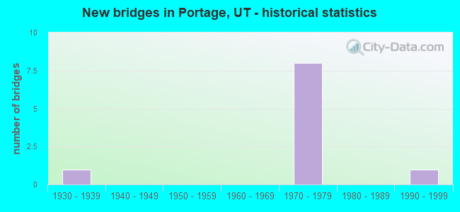
- New bridges - historical statistics
- 11930-1939
- 81970-1979
- 11990-1999


- Bridge Condition - Deck
- 33.3%Good
- 66.7%Satisfactory

- Bridge Condition - Superstructure
- 50.0%Good
- 33.3%Satisfactory
- 16.7%Poor

- Bridge Condition - Substructure
- 66.7%Satisfactory
- 33.3%Fair
Find on map >> Show street view
Structure Number: 3001F, Location: 1 MILE EAST OF PORTAGE (Lat: 41.976153, Lng: -112.216339), Route carried "on" structure: County highway 1142, Year Built: 1930, Year Reconstructed: 1978, Status: Open, Structure Length: 1.52m (4.99ft), Average Daily Traffic: 110 (year 2020), Truck Traffic: 1%, Average Future Daily Traffic: 138 (year 2040), Design Load: HL 93, Features Intersected: MALAD RIVER, Facility Carried by Structure: CO. RD., 25800 NO.
Minimum Vertical Clearance: 30+ m (98+ ft), Kilometerpoint: 16.583, Lanes on structure: 2, Owner: County Highway Agency, Approaching Roadway Width: 9.1m (29.9ft), Material/Design: Prestressed concrete, Design/Construction: Tee Beam, Number Of Spans In Main Unit: 1, Length of Maximum Span: 14.6m (47.9ft), Curb-To-Curb Width: 9.1m (29.9ft), Out-to-Out Width: 9.1m (29.9ft)
Condition: Deck: Good, Superstructure: Poor, Substructure: Fair, Channel: Satisfactory, Operating Rating: 32.4 metric tons, Method Used To Determine Operating Rating: Load and Resistance Factor Rating (LRFR) rating reported by rating factor(RF) method using HL-93 loadings, Inventory Rating: 22.0 metric tons, Method Used To Determine Inventory Rating: Load and Resistance Factor Rating (LRFR) rating reported by rating factor(RF) method using HL-93 loadings, Structural Evaluation: Meets minimum limits, Deck Geometry: Equal to present minimum criteria, Waterway Adequacy: Somewhat better than minimum adequacy, Approach Roadway Alignment: Equal to present desirable criteria, Designated Inspection Frequency: Every 24 months, Inspection Date: November 2021, Deck Structure Type: Concrete Precast Panels, Wearing Surface/Protective System: Wearing Surface: Bituminous
Find on map >> Show street view
Structure Number: 3002F, Location: 1 MILE EAST OF WASHAKIE (Lat: 41.944008, Lng: -112.197114), Route carried "on" structure: County highway 1144, Year Built: 1991, Status: Open, Structure Length: 1.68m (5.51ft), Average Daily Traffic: 380 (year 2020), Truck Traffic: 5%, Average Future Daily Traffic: 475 (year 2040), Design Load: HL 93, Features Intersected: MALAD RIVER, Facility Carried by Structure: COUNTY ROAD
Minimum Vertical Clearance: 30+ m (98+ ft), Kilometerpoint: 2.857, Lanes on structure: 2, Owner: County Highway Agency, Approaching Roadway Width: 7.3m (24.0ft), Material/Design: Prestressed concrete, Design/Construction: Tee Beam, Number Of Spans In Main Unit: 1, Length of Maximum Span: 15.5m (50.9ft), Curb-To-Curb Width: 7.3m (24.0ft), Out-to-Out Width: 7.6m (24.9ft)
Condition: Deck: Good, Superstructure: Good, Substructure: Fair, Channel: Satisfactory, Operating Rating: 32.4 metric tons, Method Used To Determine Operating Rating: Load and Resistance Factor Rating (LRFR) rating reported by rating factor(RF) method using HL-93 loadings, Inventory Rating: 21.7 metric tons, Method Used To Determine Inventory Rating: Load and Resistance Factor Rating (LRFR) rating reported by rating factor(RF) method using HL-93 loadings, Structural Evaluation: Somewhat better than minimum adequacy, Deck Geometry: Somewhat better than minimum adequacy, Waterway Adequacy: Equal to present minimum criteria, Approach Roadway Alignment: Equal to present desirable criteria, Designated Inspection Frequency: Every 24 months, Inspection Date: November 2021, Deck Structure Type: Concrete Precast Panels, Wearing Surface/Protective System: Wearing Surface: Bituminous
Find on map >> Show street view
Structure Number: 1F 372, Location: 3 MILES SO.of PORTAGE INT (Lat: 41.943825, Lng: -112.174089), Route carried "on" structure: Interstate 15, Year Built: 1976, Status: Open, Structure Length: 2.81m (9.22ft), Average Daily Traffic: 11,651 (year 2020), Truck Traffic: 28%, Average Future Daily Traffic: 14,564 (year 2040), Design Load: HS 20+Mod, Features Intersected: WASHAKIE LN.24000 No.Rd.
Minimum Vertical Clearance: 30+ m (98+ ft), Kilometerpoint: 638.394, Lanes on structure: 2, Lanes under structure: 2, Base Highway Network: Yes, Owner: State Highway Agency, Approaching Roadway Width: 12.3m (40.4ft), Skew: 1 degrees, Material/Design: Prestressed concrete, Design/Construction: Stringer/Multi-beam, Number Of Spans In Main Unit: 1, Length of Maximum Span: 27.3m (89.6ft), Curb-To-Curb Width: 12.3m (40.4ft), Out-to-Out Width: 13.4m (44.0ft)
Condition: Deck: Satisfactory, Superstructure: Good, Substructure: Satisfactory, Operating Rating: 61.6 metric tons, Method Used To Determine Operating Rating: Load Factor (LF) rating reported by rating factor (RF) method using MS18 loading, Inventory Rating: 29.8 metric tons, Method Used To Determine Inventory Rating: Load Factor (LF) rating reported by rating factor (RF) method using MS18 loading, Structural Evaluation: Equal to present minimum criteria, Deck Geometry: Better than present minimum criteria, Underclear: Meets minimum limits, Approach Roadway Alignment: Equal to present desirable criteria, Designated Inspection Frequency: Every 24 months, Inspection Date: April 2021, Deck Structure Type: Concrete Cast-file-Place, Wearing Surface/Protective System: Wearing Surface: Bituminous, Membrane: Preformed Fabric
Find on map >> Show street view
Structure Number: 1F 373, Location: PORTAGE INTERCHANGE (Lat: 41.976392, Lng: -112.189256), Route carried "on" structure: Interstate 15, Year Built: 1976, Status: Open, Structure Length: 3.18m (10.43ft), Average Daily Traffic: 11,651 (year 2020), Truck Traffic: 28%, Average Future Daily Traffic: 14,564 (year 2040), Design Load: HS 20+Mod, Features Intersected: PORTAGE INTCHG.X-ROAD
Minimum Vertical Clearance: 30+ m (98+ ft), Kilometerpoint: 642.296, Lanes on structure: 2, Lanes under structure: 2, Base Highway Network: Yes, Owner: State Highway Agency, Approaching Roadway Width: 12.3m (40.4ft), Skew: 2 degrees, Material/Design: Prestressed concrete, Design/Construction: Stringer/Multi-beam, Number Of Spans In Main Unit: 1, Length of Maximum Span: 30.9m (101.4ft), Curb-To-Curb Width: 12.3m (40.4ft), Out-to-Out Width: 13.4m (44.0ft)
Condition: Deck: Satisfactory, Superstructure: Satisfactory, Substructure: Satisfactory, Operating Rating: 35.6 metric tons, Method Used To Determine Operating Rating: Load and Resistance Factor Rating (LRFR) rating reported by rating factor(RF) method using HL-93 loadings, Inventory Rating: 31.4 metric tons, Method Used To Determine Inventory Rating: Load and Resistance Factor Rating (LRFR) rating reported by rating factor(RF) method using HL-93 loadings, Structural Evaluation: Equal to present minimum criteria, Deck Geometry: Better than present minimum criteria, Underclear: Meets minimum limits, Approach Roadway Alignment: Equal to present desirable criteria, Designated Inspection Frequency: Every 24 months, Inspection Date: April 2021, Deck Structure Type: Concrete Cast-file-Place, Wearing Surface/Protective System: Wearing Surface: Bituminous, Membrane: Preformed Fabric
Find on map >> Show street view
Structure Number: 3F 372, Location: 3 MILES SO.of PORTAGE INT (Lat: 41.944783, Lng: -112.174847), Route carried "on" structure: Interstate 15, Year Built: 1976, Status: Open, Structure Length: 2.81m (9.22ft), Average Daily Traffic: 11,651 (year 2020), Truck Traffic: 28%, Average Future Daily Traffic: 14,564 (year 2040), Design Load: HS 20+Mod, Features Intersected: WASHAKIE LN.24000 No.Rd.
Minimum Vertical Clearance: 30+ m (98+ ft), Kilometerpoint: 638.732, Lanes on structure: 2, Lanes under structure: 2, Base Highway Network: Yes, Owner: State Highway Agency, Approaching Roadway Width: 12.3m (40.4ft), Skew: 1 degrees, Material/Design: Prestressed concrete, Design/Construction: Stringer/Multi-beam, Number Of Spans In Main Unit: 1, Length of Maximum Span: 27.3m (89.6ft), Curb-To-Curb Width: 12.3m (40.4ft), Out-to-Out Width: 13.4m (44.0ft)
Condition: Deck: Satisfactory, Superstructure: Good, Substructure: Satisfactory, Operating Rating: 63.5 metric tons, Method Used To Determine Operating Rating: Load and Resistance Factor Rating (LRFR) rating reported by rating factor(RF) method using HL-93 loadings, Inventory Rating: 32.4 metric tons, Method Used To Determine Inventory Rating: Load Factor (LF) rating reported by rating factor (RF) method using MS18 loading, Structural Evaluation: Equal to present minimum criteria, Deck Geometry: Better than present minimum criteria, Underclear: Meets minimum limits, Approach Roadway Alignment: Equal to present desirable criteria, Designated Inspection Frequency: Every 24 months, Inspection Date: April 2021, Deck Structure Type: Concrete Cast-file-Place, Wearing Surface/Protective System: Wearing Surface: Bituminous, Membrane: Preformed Fabric
Find on map >> Show street view
Structure Number: 3F 373, Location: PORTAGE INTERCHANGE (Lat: 41.977269, Lng: -112.190414), Route carried "on" structure: Interstate 15, Year Built: 1976, Status: Open, Structure Length: 3.18m (10.43ft), Average Daily Traffic: 11,540 (year 2020), Truck Traffic: 28%, Average Future Daily Traffic: 14,425 (year 2040), Design Load: HS 20+Mod, Features Intersected: PORTAGE INTCHG.X-ROAD
Minimum Vertical Clearance: 30+ m (98+ ft), Kilometerpoint: 642.639, Lanes on structure: 2, Lanes under structure: 2, Base Highway Network: Yes, Owner: State Highway Agency, Approaching Roadway Width: 12.3m (40.4ft), Skew: 2 degrees, Material/Design: Prestressed concrete, Design/Construction: Stringer/Multi-beam, Number Of Spans In Main Unit: 1, Length of Maximum Span: 30.9m (101.4ft), Curb-To-Curb Width: 12.3m (40.4ft), Out-to-Out Width: 13.4m (44.0ft)
Condition: Deck: Satisfactory, Superstructure: Satisfactory, Substructure: Satisfactory, Operating Rating: 33.4 metric tons, Method Used To Determine Operating Rating: Load and Resistance Factor Rating (LRFR) rating reported by rating factor(RF) method using HL-93 loadings, Inventory Rating: 29.8 metric tons, Method Used To Determine Inventory Rating: Load and Resistance Factor Rating (LRFR) rating reported by rating factor(RF) method using HL-93 loadings, Structural Evaluation: Equal to present minimum criteria, Deck Geometry: Better than present minimum criteria, Underclear: Meets minimum limits, Approach Roadway Alignment: Equal to present desirable criteria, Designated Inspection Frequency: Every 24 months, Inspection Date: April 2021, Deck Structure Type: Concrete Cast-file-Place, Wearing Surface/Protective System: Wearing Surface: Bituminous, Membrane: Preformed Fabric
Find on map >> Show street view
Structure Number: 1F 372, Location: 3 MILES SO.of PORTAGE INT (Lat: 41.943825, Lng: -112.174089), Route carried "under" structure: County highway , Year Built: 1976, Structure Length: 0. m, Features Intersected: WASHAKIE LN.24000 No.Rd., Facility Carried by Structure: I-15 (SR-15) NBL
Minimum Vertical Clearance: 5.11m (16.77ft), Kilometerpoint: 0.000, Lanes on structure: 2, Lanes under structure: 2, Material/Design: Prestressed concrete, Design/Construction: Stringer/Multi-beam, Length of Maximum Span: 27.3m (89.6ft)
Find on map >> Show street view
Structure Number: 1F 373, Location: PORTAGE INTERCHANGE (Lat: 41.976392, Lng: -112.189256), Route carried "under" structure: County highway 1142, Year Built: 1976, Structure Length: 0. m, Features Intersected: PORTAGE INTCHG.X-ROAD, Facility Carried by Structure: I-15 (SR-15) NBL
Minimum Vertical Clearance: 5.15m (16.90ft), Kilometerpoint: 0.000, Lanes on structure: 2, Lanes under structure: 2, Material/Design: Prestressed concrete, Design/Construction: Stringer/Multi-beam, Length of Maximum Span: 30.9m (101.4ft)
Find on map >> Show street view
Structure Number: 3F 372, Location: 3 MILES SO.of PORTAGE INT (Lat: 41.944783, Lng: -112.174847), Route carried "under" structure: County highway , Year Built: 1976, Structure Length: 0. m, Features Intersected: WASHAKIE LN.24000 No.Rd., Facility Carried by Structure: I-15 (SR-15) SBL
Minimum Vertical Clearance: 5.59m (18.34ft), Kilometerpoint: 0.000, Lanes on structure: 2, Lanes under structure: 2, Material/Design: Prestressed concrete, Design/Construction: Stringer/Multi-beam, Length of Maximum Span: 27.3m (89.6ft)
Find on map >> Show street view
Structure Number: 3F 373, Location: PORTAGE INTERCHANGE (Lat: 41.977269, Lng: -112.190414), Route carried "under" structure: County highway 1142, Year Built: 1976, Structure Length: 0. m, Features Intersected: PORTAGE INTCHG.X-ROAD, Facility Carried by Structure: I-15 (SR-15) SBL
Minimum Vertical Clearance: 5.18m (16.99ft), Kilometerpoint: 0.000, Lanes on structure: 2, Lanes under structure: 2, Material/Design: Prestressed concrete, Design/Construction: Stringer/Multi-beam, Length of Maximum Span: 30.9m (101.4ft)