Bridge Statistics for Potosi, Missouri (MO)
Condition, Traffic, Stress, Structural Evaluation, Project Costs
- National Bridge Inventory (NBI) Statistics
- 23Number of bridges
- 148ft / 45.5mTotal length
- $2,233,000Total costs
- 39,823Total average daily traffic
- 5,388Total average daily truck traffic
- 71,704Total future (year 2040) average daily traffic
- National Bridge Inventory (NBI) Registered Bridges for Potosi
- No street view available for this location
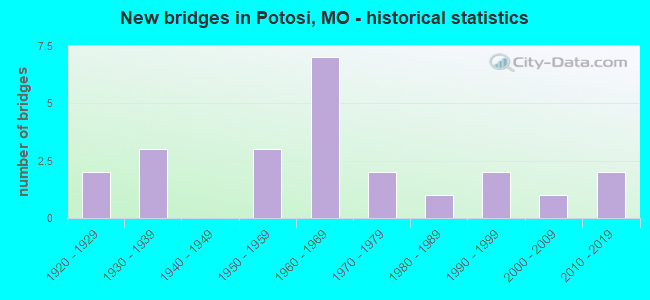
- New bridges - historical statistics
- 21920-1929
- 31930-1939
- 31950-1959
- 71960-1969
- 21970-1979
- 11980-1989
- 21990-1999
- 12000-2009
- 22010-2019


- Bridge Condition - Deck
- 13.3%Excellent
- 26.7%Good
- 53.3%Satisfactory
- 6.7%Poor

- Bridge Condition - Superstructure
- 13.3%Excellent
- 6.7%Very good
- 20.0%Good
- 46.7%Satisfactory
- 6.7%Fair
- 6.7%Poor

- Bridge Condition - Substructure
- 13.3%Excellent
- 20.0%Very good
- 13.3%Good
- 26.7%Satisfactory
- 26.7%Fair

- Bridge Condition - Channel
- 4.5%Good
- 45.5%Satisfactory
- 36.4%Fair
- 13.6%Poor

- Bridge Condition - Culverts
- 12.5%Good
- 37.5%Satisfactory
- 50.0%Fair
Find on map >> Show street view
Structure Number: 10007, Location: S 19 T 37 N R 3 E (Lat: 37.910961, Lng: -90.757078), Route carried "on" structure: State highway U, Year Built: 1935, Status: Open, Structure Length: 0.78m (2.56ft), Average Daily Traffic: 981 (year 2021), Truck Traffic: 8%, Average Future Daily Traffic: 1,373 (year 2041), Features Intersected: FK BRANCH MILL
Minimum Vertical Clearance: 30+ m (98+ ft), Kilometerpoint: 1.973, Lanes on structure: 2, Owner: State Highway Agency, Approaching Roadway Width: 7.3m (24.0ft), Material/Design: Concrete continuous, Design/Construction: Culvert, Number Of Spans In Main Unit: 4, Length of Maximum Span: 1.8m (5.9ft), Curb-To-Curb Width: 6.1m (20.0ft), Out-to-Out Width: 6.7m (22.0ft)
Condition: Channel: Fair, Culverts: Fair, Operating Rating: 24.3 metric tons, Method Used To Determine Operating Rating: Field evaluation and documented engineering judgment, Inventory Rating: 14.4 metric tons, Method Used To Determine Inventory Rating: Field evaluation and documented engineering judgment, Structural Evaluation: Meets minimum limits, Deck Geometry: High priority of corrective action, Waterway Adequacy: Equal to present desirable criteria, Approach Roadway Alignment: Equal to present minimum criteria, Length Of Structure Improvement: 0.14m (0.46ft), Designated Inspection Frequency: Every 24 months, Inspection Date: September 2020, Bridge Improvement Cost: $250,000, Roadway Improvement Cost: $25,000, Total Project Cost: $375,000 ( Estimate for 2022)
Find on map >> Show street view
Structure Number: 10008, Location: S 19 T 37 N R 3 E (Lat: 37.908497, Lng: -90.755911), Route carried "on" structure: State highway U, Year Built: 1935, Status: Open, Structure Length: 1.17m (3.84ft), Average Daily Traffic: 981 (year 2021), Truck Traffic: 8%, Average Future Daily Traffic: 1,373 (year 2041), Features Intersected: BR MILL CR
Minimum Vertical Clearance: 30+ m (98+ ft), Kilometerpoint: 2.264, Lanes on structure: 2, Owner: State Highway Agency, Approaching Roadway Width: 7.3m (24.0ft), Material/Design: Concrete continuous, Design/Construction: Culvert, Number Of Spans In Main Unit: 6, Length of Maximum Span: 1.8m (5.9ft), Curb-To-Curb Width: 6.1m (20.0ft), Out-to-Out Width: 6.7m (22.0ft)
Condition: Channel: Fair, Culverts: Fair, Operating Rating: 24.3 metric tons, Method Used To Determine Operating Rating: Field evaluation and documented engineering judgment, Inventory Rating: 14.4 metric tons, Method Used To Determine Inventory Rating: Field evaluation and documented engineering judgment, Structural Evaluation: Meets minimum limits, Deck Geometry: High priority of corrective action, Waterway Adequacy: Equal to present desirable criteria, Approach Roadway Alignment: Equal to present minimum criteria, Length Of Structure Improvement: 0.18m (0.59ft), Designated Inspection Frequency: Every 24 months, Inspection Date: September 2020, Bridge Improvement Cost: $250,000, Roadway Improvement Cost: $25,000, Total Project Cost: $375,000 ( Estimate for 2022)
Find on map >> Show street view
Structure Number: 14127, Location: S 28 T 37 N R 3 E (Lat: 37.901500, Lng: -90.715700), Route carried "on" structure: County highway 57, Year Built: 1955, Status: Open, Structure Length: 1.74m (5.71ft), Average Daily Traffic: 45 (year 2020), Truck Traffic: 10%, Average Future Daily Traffic: 54 (year 2040), Design Load: H 15, Features Intersected: HOPEWELL CR, Facility Carried by Structure: NEW DIGGINS RD
Minimum Vertical Clearance: 30+ m (98+ ft), Kilometerpoint: 0.402, Lanes on structure: 2, Owner: County Highway Agency, Approaching Roadway Width: 6.7m (22.0ft), Material/Design: Concrete continuous, Design/Construction: Slab, Number Of Spans In Main Unit: 3, Length of Maximum Span: 6.0m (19.7ft), Curb-To-Curb Width: 6.1m (20.0ft), Out-to-Out Width: 6.1m (20.0ft)
Condition: Deck: Satisfactory, Superstructure: Satisfactory, Substructure: Satisfactory, Channel: Fair, Operating Rating: 49.5 metric tons, Method Used To Determine Operating Rating: Allowable Stress (AS), Inventory Rating: 16.2 metric tons, Method Used To Determine Inventory Rating: Allowable Stress (AS), Structural Evaluation: Somewhat better than minimum adequacy, Deck Geometry: Somewhat better than minimum adequacy, Waterway Adequacy: Better than present minimum criteria, Approach Roadway Alignment: Equal to present desirable criteria, Designated Inspection Frequency: Every 24 months, Inspection Date: April 2020, Deck Structure Type: Concrete Cast-file-Place, Wearing Surface/Protective System: Wearing Surface: Bituminous
Find on map >> Show street view
Structure Number: 14128, Location: S 28 T 37 N R 3 E (Lat: 37.896300, Lng: -90.706700), Route carried "on" structure: County highway 57, Year Built: 1960, Status: Open, Structure Length: 0.79m (2.59ft), Average Daily Traffic: 45 (year 2020), Truck Traffic: 10%, Average Future Daily Traffic: 54 (year 2040), Design Load: H 15, Features Intersected: HOPEWELL CR, Facility Carried by Structure: NEW DIGGINS RD
Minimum Vertical Clearance: 30+ m (98+ ft), Kilometerpoint: 5.150, Lanes on structure: 2, Owner: County Highway Agency, Approaching Roadway Width: 6.7m (22.0ft), Material/Design: Concrete continuous, Design/Construction: Slab, Number Of Spans In Main Unit: 2, Length of Maximum Span: 3.7m (12.1ft), Curb-To-Curb Width: 5.8m (19.0ft), Out-to-Out Width: 6.1m (20.0ft)
Condition: Deck: Satisfactory, Superstructure: Satisfactory, Substructure: Fair, Channel: Fair, Operating Rating: 49.5 metric tons, Method Used To Determine Operating Rating: Allowable Stress (AS), Inventory Rating: 16.2 metric tons, Method Used To Determine Inventory Rating: Allowable Stress (AS), Structural Evaluation: Somewhat better than minimum adequacy, Deck Geometry: Meets minimum limits, Waterway Adequacy: Better than present minimum criteria, Approach Roadway Alignment: Equal to present minimum criteria, Designated Inspection Frequency: Every 24 months, Inspection Date: April 2020, Deck Structure Type: Concrete Cast-file-Place, Wearing Surface/Protective System: Wearing Surface: Bituminous
Find on map >> Show street view
Structure Number: 14274, Location: S 214 T 37 N R 2 E (Lat: 37.914700, Lng: -90.782900), Route carried "on" structure: County highway 62, Year Built: 1925, Status: Open, Structure Length: 0.79m (2.59ft), Average Daily Traffic: 125 (year 2020), Truck Traffic: 10%, Average Future Daily Traffic: 150 (year 2040), Features Intersected: BRETON CR, Facility Carried by Structure: OLD 21
Minimum Vertical Clearance: 30+ m (98+ ft), Kilometerpoint: 0.322, Lanes on structure: 2, Owner: County Highway Agency, Approaching Roadway Width: 7.3m (24.0ft), Material/Design: Concrete, Design/Construction: Slab, Number Of Spans In Main Unit: 1, Length of Maximum Span: 7.6m (24.9ft), Curb-To-Curb Width: 6.1m (20.0ft), Out-to-Out Width: 6.9m (22.6ft)
Condition: Deck: Satisfactory, Superstructure: Satisfactory, Substructure: Good, Channel: Fair, Operating Rating: 49.5 metric tons, Method Used To Determine Operating Rating: Allowable Stress (AS), Inventory Rating: 16.2 metric tons, Method Used To Determine Inventory Rating: Allowable Stress (AS), Structural Evaluation: Somewhat better than minimum adequacy, Deck Geometry: Meets minimum limits, Waterway Adequacy: Better than present minimum criteria, Approach Roadway Alignment: Equal to present desirable criteria, Designated Inspection Frequency: Every 24 months, Inspection Date: April 2020, Deck Structure Type: Concrete Cast-file-Place, Wearing Surface/Protective System: Wearing Surface: Bituminous
Find on map >> Show street view
Structure Number: 14299, Location: S 21 T 37 N R 2 E (Lat: 37.916000, Lng: -90.825700), Route carried "on" structure: County highway 63, Year Built: 1963, Status: Open, Structure Length: 1.07m (3.51ft), Average Daily Traffic: 5 (year 2020), Truck Traffic: 10%, Average Future Daily Traffic: 6 (year 2040), Design Load: H 10, Features Intersected: BATES CR, Facility Carried by Structure: BATES CREEK RD
Minimum Vertical Clearance: 30+ m (98+ ft), Kilometerpoint: 0.161, Lanes on structure: 1, Owner: County Highway Agency, Approaching Roadway Width: 4.6m (15.1ft), Material/Design: Concrete, Design/Construction: Slab, Number Of Spans In Main Unit: 3, Length of Maximum Span: 3.8m (12.5ft), Curb-To-Curb Width: 3.4m (11.2ft), Out-to-Out Width: 3.4m (11.2ft)
Condition: Deck: Satisfactory, Superstructure: Satisfactory, Substructure: Satisfactory, Channel: Satisfactory, Operating Rating: 49.5 metric tons, Method Used To Determine Operating Rating: Allowable Stress (AS), Inventory Rating: 16.2 metric tons, Method Used To Determine Inventory Rating: Allowable Stress (AS), Structural Evaluation: Somewhat better than minimum adequacy, Deck Geometry: High priority of corrective action, Waterway Adequacy: Meets minimum limits, Approach Roadway Alignment: Somewhat better than minimum adequacy, Length Of Structure Improvement: 0.17m (0.56ft), Designated Inspection Frequency: Every 24 months, Inspection Date: April 2020, Bridge Improvement Cost: $124,000, Roadway Improvement Cost: $12,000, Total Project Cost: $186,000 ( Estimate for 2022), Deck Structure Type: Concrete Cast-file-Place, Wearing Surface/Protective System: Wearing Surface: Monolithic Concrete
Find on map >> Show street view
Structure Number: 168, Location: S 18 T 37 N R 3 E (Lat: 37.924478, Lng: -90.741950), Route carried "on" structure: State highway 8, Year Built: 1968, Status: Open, Structure Length: 1.15m (3.77ft), Average Daily Traffic: 6,604 (year 2021), Truck Traffic: 10%, Average Future Daily Traffic: 12,548 (year 2041), Design Load: H 20, Features Intersected: BR MILL CR
Minimum Vertical Clearance: 30+ m (98+ ft), Kilometerpoint: 90.696, Lanes on structure: 2, Base Highway Network: Yes, Owner: State Highway Agency, Approaching Roadway Width: 11.6m (38.1ft), Material/Design: Concrete continuous, Design/Construction: Culvert, Number Of Spans In Main Unit: 3, Length of Maximum Span: 3.7m (12.1ft)
Condition: Channel: Satisfactory, Culverts: Satisfactory, Operating Rating: 72.0 metric tons, Method Used To Determine Operating Rating: Field evaluation and documented engineering judgment, Inventory Rating: 43.2 metric tons, Method Used To Determine Inventory Rating: Field evaluation and documented engineering judgment, Structural Evaluation: Equal to present minimum criteria, Waterway Adequacy: Equal to present desirable criteria, Approach Roadway Alignment: Equal to present desirable criteria, Designated Inspection Frequency: Every 24 months, Inspection Date: September 2020
Find on map >> Show street view
Structure Number: 17527, Location: S 18 T 37 N R 3 E (Lat: 37.923200, Lng: -90.742300), Route carried "on" structure: County highway 155, Year Built: 1960, Status: Open, Structure Length: 1.16m (3.81ft), Average Daily Traffic: 100 (year 2020), Truck Traffic: 10%, Average Future Daily Traffic: 120 (year 2040), Features Intersected: MILL CR, Facility Carried by Structure: SPRINGTOWN RD
Minimum Vertical Clearance: 30+ m (98+ ft), Kilometerpoint: 1.770, Lanes on structure: 2, Owner: County Highway Agency, Approaching Roadway Width: 7.3m (24.0ft), Material/Design: Concrete, Design/Construction: Culvert, Number Of Spans In Main Unit: 3, Length of Maximum Span: 3.7m (12.1ft), Curb-To-Curb Width: 6.1m (20.0ft), Out-to-Out Width: 6.7m (22.0ft)
Condition: Channel: Fair, Culverts: Satisfactory, Operating Rating: 49.5 metric tons, Method Used To Determine Operating Rating: Allowable Stress (AS), Inventory Rating: 16.2 metric tons, Method Used To Determine Inventory Rating: Allowable Stress (AS), Structural Evaluation: Somewhat better than minimum adequacy, Deck Geometry: Somewhat better than minimum adequacy, Waterway Adequacy: Better than present minimum criteria, Approach Roadway Alignment: Equal to present desirable criteria, Designated Inspection Frequency: Every 24 months, Inspection Date: April 2020, Deck Structure Type: Concrete Cast-file-Place, Wearing Surface/Protective System: Wearing Surface: Bituminous
Find on map >> Show street view
Structure Number: 22344, Location: S 430 T 37 N R 2 E (Lat: 37.938100, Lng: -90.791800), Route carried "on" structure: City street , Year Built: 1972, Status: Open, Structure Length: 2.26m (7.41ft), Average Daily Traffic: 200 (year 2020), Truck Traffic: 10%, Average Future Daily Traffic: 240 (year 2040), Design Load: H 15, Features Intersected: BRETON CR, Facility Carried by Structure: LEAD ST
Minimum Vertical Clearance: 30+ m (98+ ft), Kilometerpoint: 0.161, Lanes on structure: 2, Owner: City or Municipal Highway Agency, Approaching Roadway Width: 7.9m (25.9ft), Material/Design: Concrete continuous, Design/Construction: Slab, Number Of Spans In Main Unit: 5, Length of Maximum Span: 5.2m (17.1ft), Curb-To-Curb Width: 6.7m (22.0ft), Out-to-Out Width: 7.2m (23.6ft)
Condition: Deck: Satisfactory, Superstructure: Satisfactory, Substructure: Satisfactory, Channel: Satisfactory, Operating Rating: 49.5 metric tons, Method Used To Determine Operating Rating: Allowable Stress (AS), Inventory Rating: 16.2 metric tons, Method Used To Determine Inventory Rating: Allowable Stress (AS), Structural Evaluation: Somewhat better than minimum adequacy, Deck Geometry: Meets minimum limits, Waterway Adequacy: Better than present minimum criteria, Approach Roadway Alignment: Equal to present desirable criteria, Designated Inspection Frequency: Every 24 months, Inspection Date: April 2020, Deck Structure Type: Concrete Cast-file-Place, Wearing Surface/Protective System: Wearing Surface: Bituminous
Find on map >> Show street view
Structure Number: 22345, Location: S 430 T 37 N R 2 E (Lat: 37.936200, Lng: -90.789500), Route carried "on" structure: City street , Year Built: 1975, Status: Open, Structure Length: 1.65m (5.41ft), Average Daily Traffic: 200 (year 2020), Truck Traffic: 10%, Average Future Daily Traffic: 240 (year 2040), Design Load: H 15, Features Intersected: BRETON CR, Facility Carried by Structure: MINE ST
Minimum Vertical Clearance: 30+ m (98+ ft), Kilometerpoint: 0.322, Lanes on structure: 2, Owner: City or Municipal Highway Agency, Approaching Roadway Width: 7.9m (25.9ft), Material/Design: Concrete, Design/Construction: Slab, Number Of Spans In Main Unit: 2, Length of Maximum Span: 7.8m (25.6ft), Curb-To-Curb Width: 7.6m (24.9ft), Out-to-Out Width: 8.0m (26.2ft)
Condition: Deck: Good, Superstructure: Good, Substructure: Good, Channel: Satisfactory, Operating Rating: 49.5 metric tons, Method Used To Determine Operating Rating: Allowable Stress (AS), Inventory Rating: 16.2 metric tons, Method Used To Determine Inventory Rating: Allowable Stress (AS), Structural Evaluation: Somewhat better than minimum adequacy, Deck Geometry: Somewhat better than minimum adequacy, Waterway Adequacy: Better than present minimum criteria, Approach Roadway Alignment: Equal to present desirable criteria, Designated Inspection Frequency: Every 24 months, Inspection Date: April 2020, Deck Structure Type: Concrete Cast-file-Place, Wearing Surface/Protective System: Wearing Surface: Bituminous
Find on map >> Show street view
Structure Number: 22346, Location: S 11 T 37 N R 2 E (Lat: 37.935700, Lng: -90.788300), Route carried "on" structure: City street , Year Built: 1968, Status: Posted for load, Structure Length: 1.49m (4.89ft), Average Daily Traffic: 200 (year 2020), Truck Traffic: 10%, Average Future Daily Traffic: 240 (year 2040), Design Load: H 15, Features Intersected: BRETON CR, Facility Carried by Structure: MISSOURI ST
Minimum Vertical Clearance: 30+ m (98+ ft), Kilometerpoint: 0.483, Lanes on structure: 2, Owner: City or Municipal Highway Agency, Approaching Roadway Width: 7.3m (24.0ft), Material/Design: Concrete continuous, Design/Construction: Slab, Number Of Spans In Main Unit: 3, Length of Maximum Span: 5.1m (16.7ft), Curb-To-Curb Width: 6.1m (20.0ft), Out-to-Out Width: 6.1m (20.0ft)
Condition: Deck: Satisfactory, Superstructure: Satisfactory, Substructure: Fair, Channel: Poor, Operating Rating: 19.8 metric tons, Method Used To Determine Operating Rating: Allowable Stress (AS), Inventory Rating: 9.9 metric tons, Method Used To Determine Inventory Rating: Allowable Stress (AS), Structural Evaluation: High priority of replacement, Deck Geometry: Meets minimum limits, Waterway Adequacy: Better than present minimum criteria, Approach Roadway Alignment: Better than present minimum criteria, Bridge Posting: Required (Relationship of Operating Rating to Maximum Legal Load: 10.0 - 19.9% below), Length Of Structure Improvement: 0.22m (0.72ft), Designated Inspection Frequency: Every 24 months, Inspection Date: April 2020, Bridge Improvement Cost: $160,000, Roadway Improvement Cost: $16,000, Total Project Cost: $240,000 ( Estimate for 2022), Deck Structure Type: Concrete Cast-file-Place, Wearing Surface/Protective System: Wearing Surface: Monolithic Concrete
Find on map >> Show street view
Structure Number: 22347, Location: S 11 T 37 N R 2 E (Lat: 37.935000, Lng: -90.787100), Route carried "on" structure: City street , Year Built: 1950, Status: Posted for load, Structure Length: 0.91m (2.99ft), Average Daily Traffic: 200 (year 2020), Truck Traffic: 10%, Average Future Daily Traffic: 240 (year 2040), Design Load: H 15, Features Intersected: BRETON CR, Facility Carried by Structure: WATER ST
Minimum Vertical Clearance: 30+ m (98+ ft), Kilometerpoint: 0.644, Lanes on structure: 2, Owner: City or Municipal Highway Agency, Approaching Roadway Width: 7.3m (24.0ft), Material/Design: Concrete continuous, Design/Construction: Slab, Number Of Spans In Main Unit: 2, Length of Maximum Span: 4.6m (15.1ft), Curb-To-Curb Width: 5.5m (18.0ft), Out-to-Out Width: 5.8m (19.0ft)
Condition: Deck: Poor, Superstructure: Poor, Substructure: Fair, Channel: Poor, Operating Rating: 21.6 metric tons, Method Used To Determine Operating Rating: Allowable Stress (AS), Inventory Rating: 11.7 metric tons, Method Used To Determine Inventory Rating: Allowable Stress (AS), Structural Evaluation: Meets minimum limits, Deck Geometry: High priority of corrective action, Waterway Adequacy: Better than present minimum criteria, Approach Roadway Alignment: Equal to present desirable criteria, Bridge Posting: Required (Relationship of Operating Rating to Maximum Legal Load: 10.0 - 19.9% below), Length Of Structure Improvement: 0.16m (0.52ft), Designated Inspection Frequency: Every 24 months, Inspection Date: April 2020, Bridge Improvement Cost: $115,000, Roadway Improvement Cost: $12,000, Total Project Cost: $173,000 ( Estimate for 2022), Deck Structure Type: Concrete Cast-file-Place, Wearing Surface/Protective System: Wearing Surface: Bituminous
Find on map >> Show street view
Structure Number: 22349, Location: S 14 T 37 N R 2 E (Lat: 37.932000, Lng: -90.781700), Route carried "on" structure: City street , Year Built: 1965, Status: Posted for load, Structure Length: 1.10m (3.61ft), Average Daily Traffic: 200 (year 2020), Truck Traffic: 10%, Average Future Daily Traffic: 240 (year 2040), Design Load: H 15, Features Intersected: BRETON CR, Facility Carried by Structure: UNNAMED ST
Minimum Vertical Clearance: 30+ m (98+ ft), Kilometerpoint: 0.966, Lanes on structure: 2, Owner: City or Municipal Highway Agency, Approaching Roadway Width: 7.3m (24.0ft), Material/Design: Concrete continuous, Design/Construction: Slab, Number Of Spans In Main Unit: 4, Length of Maximum Span: 2.7m (8.9ft), Curb-To-Curb Width: 6.1m (20.0ft), Out-to-Out Width: 6.1m (20.0ft)
Condition: Deck: Satisfactory, Superstructure: Satisfactory, Substructure: Fair, Channel: Poor, Operating Rating: 21.6 metric tons, Method Used To Determine Operating Rating: Allowable Stress (AS), Inventory Rating: 12.6 metric tons, Method Used To Determine Inventory Rating: Allowable Stress (AS), Structural Evaluation: Meets minimum limits, Deck Geometry: Meets minimum limits, Waterway Adequacy: Meets minimum limits, Approach Roadway Alignment: Equal to present minimum criteria, Bridge Posting: Required (Relationship of Operating Rating to Maximum Legal Load: 10.0 - 19.9% below), Designated Inspection Frequency: Every 24 months, Inspection Date: April 2020, Deck Structure Type: Concrete Cast-file-Place, Wearing Surface/Protective System: Wearing Surface: Bituminous
Find on map >> Show street view
Structure Number: 29118, Location: S 430 T 37 N R 2 E (Lat: 37.939278, Lng: -90.791911), Route carried "on" structure: State highway 8, Year Built: 2002, Status: Open, Structure Length: 4.36m (14.30ft), Average Daily Traffic: 7,131 (year 2021), Truck Traffic: 24%, Average Future Daily Traffic: 13,549 (year 2041), Design Load: HS 25 or greater, Features Intersected: BRETON CR
Minimum Vertical Clearance: 30+ m (98+ ft), Kilometerpoint: 85.765, Lanes on structure: 2, Base Highway Network: Yes, Owner: State Highway Agency, Approaching Roadway Width: 13.4m (44.0ft), Skew: 4 degrees, Material/Design: Prestressed concrete continuous, Design/Construction: Stringer/Multi-beam, Number Of Spans In Main Unit: 3, Length of Maximum Span: 14.6m (47.9ft), Curb or Sidewalk Widths: Left: 0.0m, Right: 1.8m (5.9ft), Curb-To-Curb Width: 13.4m (44.0ft), Out-to-Out Width: 14.2m (46.6ft)
Condition: Deck: Good, Superstructure: Very good, Substructure: Very good, Channel: Good, Operating Rating: 81.9 metric tons, Method Used To Determine Operating Rating: Load Factor (LF), Inventory Rating: 48.6 metric tons, Method Used To Determine Inventory Rating: Load Factor (LF), Structural Evaluation: Equal to present desirable criteria, Deck Geometry: Equal to present minimum criteria, Waterway Adequacy: Superior to present desirable criteria, Approach Roadway Alignment: Equal to present desirable criteria, Designated Inspection Frequency: Every 24 months, Inspection Date: September 2020, Deck Structure Type: Concrete Cast-file-Place, Wearing Surface/Protective System: Wearing Surface: Monolithic Concrete, Deck Protection: Epoxy Coated Reinforcing
Find on map >> Show street view
Structure Number: 3458, Location: S 28 T 37 N R 2 E (Lat: 37.897456, Lng: -90.820461), Route carried "on" structure: State highway P, Year Built: 1984, Status: Open, Structure Length: 1.22m (4.00ft), Average Daily Traffic: 1,087 (year 2021), Truck Traffic: 11%, Average Future Daily Traffic: 1,522 (year 2041), Design Load: H 15, Features Intersected: BATES CR
Minimum Vertical Clearance: 30+ m (98+ ft), Kilometerpoint: 5.797, Lanes on structure: 2, Owner: State Highway Agency, Approaching Roadway Width: 6.1m (20.0ft), Skew: 2 degrees, Material/Design: Concrete continuous, Design/Construction: Culvert, Number Of Spans In Main Unit: 3, Length of Maximum Span: 3.7m (12.1ft)
Condition: Channel: Satisfactory, Culverts: Good, Operating Rating: 38.7 metric tons, Method Used To Determine Operating Rating: Load Factor (LF), Inventory Rating: 23.4 metric tons, Method Used To Determine Inventory Rating: Load Factor (LF), Structural Evaluation: Equal to present minimum criteria, Waterway Adequacy: Equal to present desirable criteria, Approach Roadway Alignment: Equal to present desirable criteria, Designated Inspection Frequency: Every 24 months, Inspection Date: September 2020
Find on map >> Show street view
Structure Number: 34862, Location: S 1849 T 37 N R 2 E (Lat: 37.930667, Lng: -90.780250), Route carried "on" structure: City street , Year Built: 2014, Status: Open, Structure Length: 1.62m (5.31ft), Average Daily Traffic: 200 (year 2020), Truck Traffic: 10%, Average Future Daily Traffic: 240 (year 2040), Design Load: HS 20+Mod, Features Intersected: BRETON CR, Facility Carried by Structure: HALL ST
Minimum Vertical Clearance: 30+ m (98+ ft), Kilometerpoint: 0.225, Lanes on structure: 2, Owner: City or Municipal Highway Agency, Approaching Roadway Width: 6.1m (20.0ft), Material/Design: Prestressed concrete, Design/Construction: Box Beam or Girders - Multiple, Number Of Spans In Main Unit: 1, Length of Maximum Span: 15.2m (49.9ft), Curb-To-Curb Width: 6.7m (22.0ft), Out-to-Out Width: 7.3m (24.0ft)
Condition: Deck: Excellent, Superstructure: Excellent, Substructure: Excellent, Channel: Satisfactory, Operating Rating: 54.0 metric tons, Method Used To Determine Operating Rating: Load Factor (LF), Inventory Rating: 32.4 metric tons, Method Used To Determine Inventory Rating: Load Factor (LF), Structural Evaluation: Equal to present desirable criteria, Deck Geometry: Meets minimum limits, Waterway Adequacy: Meets minimum limits, Approach Roadway Alignment: Equal to present desirable criteria, Designated Inspection Frequency: Every 24 months, Inspection Date: April 2020, Deck Structure Type: Concrete Cast-file-Place, Wearing Surface/Protective System: Wearing Surface: Monolithic Concrete
Find on map >> Show street view
Structure Number: 36374, Location: S 11 T 37 N R 2 E (Lat: 37.933833, Lng: -90.785042), Route carried "on" structure: City street , Year Built: 2019, Status: Open, Structure Length: 1.07m (3.51ft), Average Daily Traffic: 200 (year 2020), Truck Traffic: 10%, Average Future Daily Traffic: 260 (year 2040), Features Intersected: BRETON CR, Facility Carried by Structure: MILL ST
Minimum Vertical Clearance: 30+ m (98+ ft), Kilometerpoint: 0.805, Lanes on structure: 2, Owner: City or Municipal Highway Agency, Approaching Roadway Width: 7.0m (23.0ft), Material/Design: Concrete, Design/Construction: Slab, Number Of Spans In Main Unit: 1, Length of Maximum Span: 9.8m (32.2ft), Curb or Sidewalk Widths: Left: 1.7m (5.6ft), Right: 0.0m, Curb-To-Curb Width: 7.0m (23.0ft), Out-to-Out Width: 9.1m (29.9ft)
Condition: Deck: Excellent, Superstructure: Excellent, Substructure: Excellent, Channel: Satisfactory, Operating Rating: 90.0 metric tons, Method Used To Determine Operating Rating: Load Factor (LF), Inventory Rating: 54.0 metric tons, Method Used To Determine Inventory Rating: Load Factor (LF), Structural Evaluation: Superior to present desirable criteria, Deck Geometry: Meets minimum limits, Waterway Adequacy: Superior to present desirable criteria, Approach Roadway Alignment: Equal to present desirable criteria, Designated Inspection Frequency: Every 24 months, Inspection Date: April 2020, Deck Structure Type: Concrete Precast Panels
Find on map >> Show street view
Structure Number: 3876, Location: S 430 T 37 N R 2 E (Lat: 37.943061, Lng: -90.806492), Route carried "on" structure: State highway 8, Year Built: 1992, Status: Open, Structure Length: 5.52m (18.11ft), Average Daily Traffic: 3,705 (year 2021), Truck Traffic: 15%, Average Future Daily Traffic: 7,040 (year 2041), Design Load: HS 25 or greater, Features Intersected: BATES CR
Minimum Vertical Clearance: 30+ m (98+ ft), Kilometerpoint: 84.262, Lanes on structure: 2, Base Highway Network: Yes, Owner: State Highway Agency, Approaching Roadway Width: 13.4m (44.0ft), Skew: 3 degrees, Material/Design: Prestressed concrete continuous, Design/Construction: Stringer/Multi-beam, Number Of Spans In Main Unit: 3, Length of Maximum Span: 18.5m (60.7ft), Curb or Sidewalk Widths: Left: 0.2m (0.7ft), Right: 0.2m (0.7ft), Curb-To-Curb Width: 13.0m (42.7ft), Out-to-Out Width: 13.9m (45.6ft)
Condition: Deck: Good, Superstructure: Fair, Substructure: Very good, Channel: Satisfactory, Operating Rating: 79.2 metric tons, Method Used To Determine Operating Rating: Load Factor (LF), Inventory Rating: 48.6 metric tons, Method Used To Determine Inventory Rating: Load Factor (LF), Structural Evaluation: Somewhat better than minimum adequacy, Deck Geometry: Equal to present minimum criteria, Waterway Adequacy: Equal to present desirable criteria, Approach Roadway Alignment: Equal to present desirable criteria, Designated Inspection Frequency: Every 24 months, Inspection Date: September 2020, Deck Structure Type: Concrete Cast-file-Place, Wearing Surface/Protective System: Wearing Surface: Monolithic Concrete, Deck Protection: Epoxy Coated Reinforcing
Find on map >> Show street view
Structure Number: 423, Location: S 36 T 38 N R 2 E (Lat: 37.977883, Lng: -90.765078), Route carried "on" structure: State highway 21, Year Built: 1993, Status: Open, Structure Length: 6.34m (20.80ft), Average Daily Traffic: 7,700 (year 2021), Truck Traffic: 9%, Average Future Daily Traffic: 14,630 (year 2041), Design Load: HS 20, Features Intersected: UP RR
Minimum Vertical Clearance: 30+ m (98+ ft), Kilometerpoint: 88.326, Lanes on structure: 2, Base Highway Network: Yes, Owner: State Highway Agency, Approaching Roadway Width: 12.2m (40.0ft), Skew: 10 degrees, Material/Design: Prestressed concrete, Design/Construction: Stringer/Multi-beam, Number Of Spans In Main Unit: 3, Length of Maximum Span: 21.2m (69.6ft), Curb or Sidewalk Widths: Left: 0.2m (0.7ft), Right: 0.2m (0.7ft), Curb-To-Curb Width: 11.8m (38.7ft), Out-to-Out Width: 12.6m (41.3ft)
Condition: Deck: Good, Superstructure: Good, Substructure: Very good, Operating Rating: 53.1 metric tons, Method Used To Determine Operating Rating: Load Factor (LF), Inventory Rating: 31.5 metric tons, Method Used To Determine Inventory Rating: Load Factor (LF), Structural Evaluation: Better than present minimum criteria, Deck Geometry: Somewhat better than minimum adequacy, Underclear: Superior to present desirable criteria, Approach Roadway Alignment: Equal to present desirable criteria, Designated Inspection Frequency: Every 24 months, Inspection Date: September 2020, Deck Structure Type: Concrete Cast-file-Place, Wearing Surface/Protective System: Wearing Surface: Monolithic Concrete, Deck Protection: Internally Sealed
Find on map >> Show street view
Structure Number: 5012, Location: S 17 T 37 N R 2 E (Lat: 37.932231, Lng: -90.829883), Route carried "on" structure: State highway 8, Year Built: 1930, Status: Open, Structure Length: 0.93m (3.05ft), Average Daily Traffic: 3,705 (year 2021), Truck Traffic: 15%, Average Future Daily Traffic: 7,040 (year 2041), Design Load: H 15, Features Intersected: BR OF BRETON CR
Minimum Vertical Clearance: 30+ m (98+ ft), Kilometerpoint: 81.876, Lanes on structure: 2, Base Highway Network: Yes, Owner: State Highway Agency, Approaching Roadway Width: 9.1m (29.9ft), Skew: 3 degrees, Material/Design: Concrete continuous, Design/Construction: Culvert, Number Of Spans In Main Unit: 2, Length of Maximum Span: 3.7m (12.1ft), Curb-To-Curb Width: 10.2m (33.5ft), Out-to-Out Width: 10.8m (35.4ft)
Condition: Channel: Fair, Culverts: Fair, Operating Rating: 83.7 metric tons, Method Used To Determine Operating Rating: Load Factor (LF), Inventory Rating: 50.4 metric tons, Method Used To Determine Inventory Rating: Load Factor (LF), Structural Evaluation: Somewhat better than minimum adequacy, Deck Geometry: Meets minimum limits, Waterway Adequacy: Equal to present desirable criteria, Approach Roadway Alignment: Equal to present minimum criteria, Designated Inspection Frequency: Every 24 months, Inspection Date: September 2020
Find on map >> Show street view
Structure Number: 5229, Location: S 16 T 37 N R 2 E (Lat: 37.942078, Lng: -90.810253), Route carried "on" structure: State highway 8, Year Built: 1929, Status: Open, Structure Length: 0.96m (3.15ft), Average Daily Traffic: 3,705 (year 2021), Truck Traffic: 15%, Average Future Daily Traffic: 7,040 (year 2041), Design Load: H 15, Features Intersected: BRETON CR
Minimum Vertical Clearance: 30+ m (98+ ft), Kilometerpoint: 83.937, Lanes on structure: 2, Base Highway Network: Yes, Owner: State Highway Agency, Approaching Roadway Width: 9.1m (29.9ft), Skew: 4 degrees, Material/Design: Concrete continuous, Design/Construction: Culvert, Number Of Spans In Main Unit: 2, Length of Maximum Span: 3.0m (9.8ft), Curb-To-Curb Width: 10.4m (34.1ft), Out-to-Out Width: 11.0m (36.1ft)
Condition: Channel: Fair, Culverts: Fair, Operating Rating: 47.7 metric tons, Method Used To Determine Operating Rating: Load Factor (LF), Inventory Rating: 28.8 metric tons, Method Used To Determine Inventory Rating: Load Factor (LF), Structural Evaluation: Somewhat better than minimum adequacy, Deck Geometry: Somewhat better than minimum adequacy, Waterway Adequacy: Equal to present desirable criteria, Approach Roadway Alignment: Equal to present desirable criteria, Designated Inspection Frequency: Every 24 months, Inspection Date: September 2020
Find on map >> Show street view
Structure Number: 546, Location: S 430 T 37 N R 2 E (Lat: 37.947506, Lng: -90.800314), Route carried "on" structure: State highway 185, Year Built: 1963, Status: Open, Structure Length: 6.55m (21.49ft), Average Daily Traffic: 1,288 (year 2021), Truck Traffic: 12%, Average Future Daily Traffic: 1,803 (year 2041), Design Load: H 20, Features Intersected: BATES CR
Minimum Vertical Clearance: 30+ m (98+ ft), Kilometerpoint: 105.481, Lanes on structure: 2, Owner: State Highway Agency, Approaching Roadway Width: 6.7m (22.0ft), Skew: 3 degrees, Material/Design: Steel continuous, Design/Construction: Stringer/Multi-beam, Number Of Spans In Main Unit: 3, Length of Maximum Span: 24.4m (80.1ft), Curb-To-Curb Width: 6.7m (22.0ft), Out-to-Out Width: 9.1m (29.9ft)
Condition: Deck: Satisfactory, Superstructure: Good, Substructure: Satisfactory, Channel: Satisfactory, Operating Rating: 37.8 metric tons, Method Used To Determine Operating Rating: Allowable Stress (AS), Inventory Rating: 22.5 metric tons, Method Used To Determine Inventory Rating: Allowable Stress (AS), Structural Evaluation: Equal to present minimum criteria, Deck Geometry: High priority of corrective action, Waterway Adequacy: Equal to present desirable criteria, Approach Roadway Alignment: Equal to present desirable criteria, Length Of Structure Improvement: 0.76m (2.49ft), Designated Inspection Frequency: Every 24 months, Inspection Date: September 2020, Bridge Improvement Cost: $589,000, Roadway Improvement Cost: $59,000, Total Project Cost: $884,000 ( Estimate for 2022), Deck Structure Type: Concrete Cast-file-Place, Wearing Surface/Protective System: Wearing Surface: Bituminous
Find on map >> Show street view
Structure Number: 7875, Location: S 430 T 38 N R 2 E (Lat: 37.966700, Lng: -90.795019), Route carried "on" structure: State highway F, Year Built: 1955, Status: Open, Structure Length: 0.82m (2.69ft), Average Daily Traffic: 1,216 (year 2021), Truck Traffic: 5%, Average Future Daily Traffic: 1,702 (year 2041), Design Load: H 10, Features Intersected: BR OF BRETON CR
Minimum Vertical Clearance: 30+ m (98+ ft), Kilometerpoint: 10.699, Lanes on structure: 2, Owner: State Highway Agency, Approaching Roadway Width: 7.3m (24.0ft), Skew: 4 degrees, Material/Design: Concrete continuous, Design/Construction: Culvert, Number Of Spans In Main Unit: 2, Length of Maximum Span: 3.0m (9.8ft), Curb-To-Curb Width: 9.1m (29.9ft), Out-to-Out Width: 10.0m (32.8ft)
Condition: Channel: Satisfactory, Culverts: Satisfactory, Operating Rating: 40.5 metric tons, Method Used To Determine Operating Rating: Load Factor (LF), Inventory Rating: 24.3 metric tons, Method Used To Determine Inventory Rating: Load Factor (LF), Structural Evaluation: Equal to present minimum criteria, Deck Geometry: Somewhat better than minimum adequacy, Waterway Adequacy: Equal to present minimum criteria, Approach Roadway Alignment: Equal to present minimum criteria, Designated Inspection Frequency: Every 24 months, Inspection Date: September 2020