Bridge Statistics for Poulsbo, Washington (WA)
Condition, Traffic, Stress, Structural Evaluation, Project Costs
- National Bridge Inventory (NBI) Statistics
- 10Number of bridges
- 82ft / 24.7mTotal length
- $12,761,000Total costs
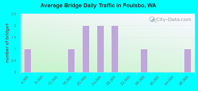
- 223,726Total average daily traffic
- 13,505Total average daily truck traffic
- National Bridge Inventory (NBI) Registered Bridges for Poulsbo
- No street view available for this location
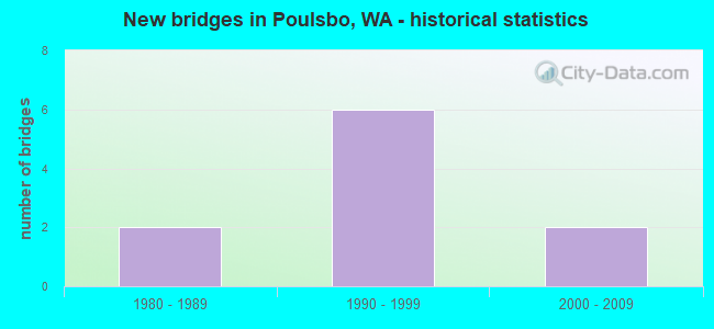
- New bridges - historical statistics
- 21980-1989
- 61990-1999
- 22000-2009
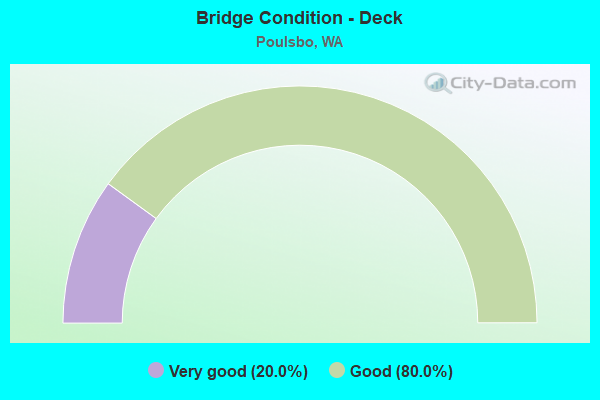
- Bridge Condition - Deck
- 20.0%Very good
- 80.0%Good
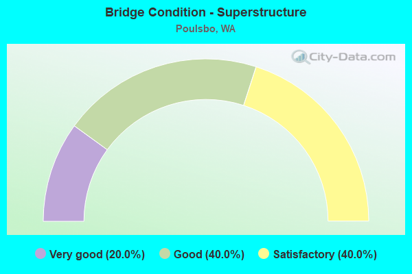
- Bridge Condition - Superstructure
- 20.0%Very good
- 40.0%Good
- 40.0%Satisfactory

- Bridge Condition - Substructure
- 20.0%Very good
- 80.0%Good
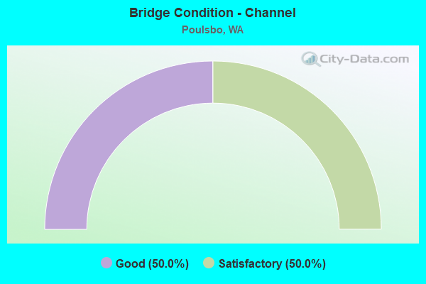
- Bridge Condition - Channel
- 50.0%Good
- 50.0%Satisfactory
Find on map >> Show street view
Structure Number: 11375E, Location: 1.7 N JCT SR 308 (Lat: 47.727833, Lng: -122.677278), Route carried "on" structure: City street , Year Built: 1981, Status: Open, Structure Length: 7.77m (25.49ft), Average Daily Traffic: 545 (year 2009), Truck Traffic: 2%, Average Future Daily Traffic: 898 (year 2036), Design Load: HS 20+Mod, Features Intersected: SR 3, Facility Carried by Structure: SHERMAN HILL RD
Minimum Vertical Clearance: 30+ m (98+ ft), Kilometerpoint: 1.207, Lanes on structure: 2, Lanes under structure: 4, Owner: State Highway Agency, Approaching Roadway Width: 9.1m (29.9ft), Skew: 2 degrees, Material/Design: Prestressed concrete continuous, Design/Construction: Stringer/Multi-beam, Number Of Spans In Main Unit: 2, Length of Maximum Span: 44.2m (145.0ft), Curb-To-Curb Width: 10.4m (34.1ft), Out-to-Out Width: 11.3m (37.1ft)
Condition: Deck: Good, Superstructure: Satisfactory, Substructure: Good, Operating Rating: 57.1 metric tons, Method Used To Determine Operating Rating: Load Factor (LF), Inventory Rating: 33.6 metric tons, Method Used To Determine Inventory Rating: Load Factor (LF), Structural Evaluation: Equal to present minimum criteria, Deck Geometry: Equal to present minimum criteria, Underclear: Somewhat better than minimum adequacy, Approach Roadway Alignment: Equal to present desirable criteria, Length Of Structure Improvement: 7.77m (25.49ft), Designated Inspection Frequency: Every 24 months, Inspection Date: April 2021, Bridge Improvement Cost: $1,632,000, Roadway Improvement Cost: $326,000, Total Project Cost: $3,264,000 ( Estimate for 2014), Deck Structure Type: Concrete Cast-file-Place, Wearing Surface/Protective System: Wearing Surface: Bituminous, Membrane: Preformed Fabric
Find on map >> Show street view
Structure Number: 14066A, Location: 4.3 N JCT SR 308 (Lat: 47.758167, Lng: -122.656500), Route carried "on" structure: State highway 3, Year Built: 1993, Status: Open, Structure Length: 4.11m (13.48ft), Average Daily Traffic: 16,972 (year 2019), Truck Traffic: 7%, Average Future Daily Traffic: 22,538 (year 2039), Design Load: HS 25 or greater, Features Intersected: SR 305
Minimum Vertical Clearance: 30+ m (98+ ft), Kilometerpoint: 84.893, Lanes on structure: 2, Lanes under structure: 4, Base Highway Network: Yes, Owner: State Highway Agency, Approaching Roadway Width: 11.6m (38.1ft), Material/Design: Prestressed concrete, Design/Construction: Stringer/Multi-beam, Number Of Spans In Main Unit: 1, Length of Maximum Span: 39.6m (129.9ft), Curb-To-Curb Width: 11.6m (38.1ft), Out-to-Out Width: 12.5m (41.0ft)
Condition: Deck: Good, Superstructure: Good, Substructure: Good, Operating Rating: 89.8 metric tons, Method Used To Determine Operating Rating: Load Factor (LF), Inventory Rating: 52.6 metric tons, Method Used To Determine Inventory Rating: Load Factor (LF), Structural Evaluation: Better than present minimum criteria, Deck Geometry: Equal to present minimum criteria, Underclear: High priority of corrective action, Approach Roadway Alignment: Equal to present desirable criteria, Length Of Structure Improvement: 4.11m (13.48ft), Designated Inspection Frequency: Every 24 months, Inspection Date: Febuary 2020, Bridge Improvement Cost: $1,080,000, Roadway Improvement Cost: $216,000, Total Project Cost: $2,160,000 ( Estimate for 2014), Deck Structure Type: Concrete Cast-file-Place, Wearing Surface/Protective System: Wearing Surface: Monolithic Concrete, Deck Protection: Epoxy Coated Reinforcing
Find on map >> Show street view
Structure Number: 14066B, Location: 4.3 N JCT SR 308 (Lat: 47.758278, Lng: -122.656944), Route carried "on" structure: State highway 3, Year Built: 1993, Status: Open, Structure Length: 3.81m (12.50ft), Average Daily Traffic: 16,972 (year 2019), Truck Traffic: 7%, Average Future Daily Traffic: 22,538 (year 2039), Design Load: HS 25 or greater, Features Intersected: SR 305
Minimum Vertical Clearance: 30+ m (98+ ft), Kilometerpoint: 84.893, Lanes on structure: 3, Lanes under structure: 4, Base Highway Network: Yes, Owner: State Highway Agency, Approaching Roadway Width: 18.6m (61.0ft), Material/Design: Prestressed concrete, Design/Construction: Stringer/Multi-beam, Number Of Spans In Main Unit: 1, Length of Maximum Span: 36.6m (120.1ft), Curb-To-Curb Width: 17.8m (58.4ft), Out-to-Out Width: 19.0m (62.3ft)
Condition: Deck: Good, Superstructure: Good, Substructure: Good, Operating Rating: 87.1 metric tons, Method Used To Determine Operating Rating: Load Factor (LF), Inventory Rating: 52.6 metric tons, Method Used To Determine Inventory Rating: Load Factor (LF), Structural Evaluation: Better than present minimum criteria, Deck Geometry: Better than present minimum criteria, Underclear: High priority of corrective action, Approach Roadway Alignment: Equal to present desirable criteria, Length Of Structure Improvement: 3.81m (12.50ft), Designated Inspection Frequency: Every 24 months, Inspection Date: Febuary 2020, Bridge Improvement Cost: $1,575,000, Roadway Improvement Cost: $315,000, Total Project Cost: $3,150,000 ( Estimate for 2014), Deck Structure Type: Concrete Cast-file-Place, Wearing Surface/Protective System: Wearing Surface: Monolithic Concrete, Deck Protection: Epoxy Coated Reinforcing
Find on map >> Show street view
Structure Number: 14276A, Location: 3.8 N JCT SR 308 (Lat: 47.753111, Lng: -122.663667), Route carried "on" structure: County highway , Year Built: 1994, Status: Open, Structure Length: 5.67m (18.60ft), Average Daily Traffic: 13,863 (year 2018), Truck Traffic: 7%, Average Future Daily Traffic: 23,359 (year 2040), Design Load: HS 25 or greater, Features Intersected: SR 3, Facility Carried by Structure: FINN HILL ROAD
Minimum Vertical Clearance: 30+ m (98+ ft), Kilometerpoint: 0.145, Lanes on structure: 3, Lanes under structure: 4, Owner: State Highway Agency, Approaching Roadway Width: 14.0m (45.9ft), Skew: 1 degrees, Material/Design: Prestressed concrete continuous, Design/Construction: Stringer/Multi-beam, Number Of Spans In Main Unit: 2, Length of Maximum Span: 27.7m (90.9ft), Curb-To-Curb Width: 14.0m (45.9ft), Out-to-Out Width: 14.9m (48.9ft)
Condition: Deck: Good, Superstructure: Satisfactory, Substructure: Good, Operating Rating: 72.6 metric tons, Method Used To Determine Operating Rating: Load Factor (LF), Inventory Rating: 42.6 metric tons, Method Used To Determine Inventory Rating: Load Factor (LF), Structural Evaluation: Equal to present minimum criteria, Deck Geometry: Somewhat better than minimum adequacy, Underclear: Equal to present minimum criteria, Approach Roadway Alignment: Equal to present desirable criteria, Length Of Structure Improvement: 5.67m (18.60ft), Designated Inspection Frequency: Every 24 months, Inspection Date: April 2021, Bridge Improvement Cost: $1,786,000, Roadway Improvement Cost: $357,000, Total Project Cost: $3,571,000 ( Estimate for 2014), Deck Structure Type: Concrete Cast-file-Place, Wearing Surface/Protective System: Wearing Surface: Monolithic Concrete, Deck Protection: Epoxy Coated Reinforcing
Find on map >> Show street view
Structure Number: 17164A, Location: 0.1 N JCT SR 305 (Lat: 47.752611, Lng: -122.644306), Route carried "on" structure: State highway 307, Year Built: 2007, Status: Open, Structure Length: 0.67m (2.20ft), Average Daily Traffic: 20,188 (year 2019), Truck Traffic: 4%, Average Future Daily Traffic: 26,809 (year 2039), Design Load: HS 25 or greater, Features Intersected: Dogfish Creek
Minimum Vertical Clearance: 30+ m (98+ ft), Kilometerpoint: 0.129, Lanes on structure: 4, Base Highway Network: Yes, Owner: State Highway Agency, Approaching Roadway Width: 20.7m (67.9ft), Skew: 3 degrees, Material/Design: Concrete, Design/Construction: Culvert, Number Of Spans In Main Unit: 1, Length of Maximum Span: 6.7m (22.0ft)
Condition: Channel: Satisfactory, Culverts: Very good, Operating Rating: 47.3 metric tons, Method Used To Determine Operating Rating: Load and Resistance Factor Rating (LRFR) rating reported by rating factor(RF) method using HL-93 loadings, Inventory Rating: 36.6 metric tons, Method Used To Determine Inventory Rating: Load and Resistance Factor Rating (LRFR) rating reported by rating factor(RF) method using HL-93 loadings, Structural Evaluation: Equal to present desirable criteria, Waterway Adequacy: Equal to present desirable criteria, Approach Roadway Alignment: Equal to present desirable criteria, Length Of Structure Improvement: 0.67m (2.20ft), Designated Inspection Frequency: Every 48 months, Inspection Date: April 2018, Bridge Improvement Cost: $308,000, Roadway Improvement Cost: $62,000, Total Project Cost: $616,000 ( Estimate for 2014)
Find on map >> Show street view
Structure Number: 88685, Location: Located on NW Lindvig Wy (Lat: 47.746861, Lng: -122.651972), Route carried "on" structure: Business City street 1010, Year Built: 2003, Status: Open, Structure Length: 2.68m (8.79ft), Average Daily Traffic: 23,262 (year 2020), Truck Traffic: 5%, Average Future Daily Traffic: 35,305 (year 2040), Design Load: HS 25 or greater, Features Intersected: Dogfish Creek, Facility Carried by Structure: NW Lindvig Way
Minimum Vertical Clearance: 30+ m (98+ ft), Kilometerpoint: 0.001, Lanes on structure: 4, Owner: City or Municipal Highway Agency, Approaching Roadway Width: 17.1m (56.1ft), Material/Design: Prestressed concrete, Design/Construction: Stringer/Multi-beam, Number Of Spans In Main Unit: 1, Length of Maximum Span: 25.9m (85.0ft), Curb or Sidewalk Widths: Left: 2.0m (6.6ft), Right: 2.0m (6.6ft), Curb-To-Curb Width: 17.1m (56.1ft), Out-to-Out Width: 21.6m (70.9ft)
Condition: Deck: Very good, Superstructure: Very good, Substructure: Very good, Channel: Good, Operating Rating: 42.4 metric tons, Method Used To Determine Operating Rating: Load and Resistance Factor Rating (LRFR) rating reported by rating factor(RF) method using HL-93 loadings, Inventory Rating: 32.7 metric tons, Method Used To Determine Inventory Rating: Load and Resistance Factor Rating (LRFR) rating reported by rating factor(RF) method using HL-93 loadings, Structural Evaluation: Equal to present desirable criteria, Deck Geometry: Somewhat better than minimum adequacy, Waterway Adequacy: Equal to present desirable criteria, Approach Roadway Alignment: Equal to present desirable criteria, Designated Inspection Frequency: Every 24 months, Inspection Date: October 2020, Deck Structure Type: Other, Wearing Surface/Protective System: Wearing Surface: Bituminous, Deck Protection: Epoxy Coated Reinforcing
Find on map >> Show street view
Structure Number: 11375E, Location: 1.7 N JCT SR 308 (Lat: 47.727833, Lng: -122.677278), Route carried "under" structure: State highway 3, Year Built: 1981, Structure Length: 0. m, Average Daily Traffic: 45,244 (year 2019), Truck Traffic: 7%, Features Intersected: SR 3, Facility Carried by Structure: SHERMAN HILL RD
Minimum Vertical Clearance: 5.56m (18.24ft), Kilometerpoint: 81.014, Lanes on structure: 2, Lanes under structure: 4, Material/Design: Prestressed concrete continuous, Design/Construction: Stringer/Multi-beam, Length of Maximum Span: 44.2m (145.0ft)
Find on map >> Show street view
Structure Number: 14066A, Location: JCT SR 3 (Lat: 47.758167, Lng: -122.656500), Route carried "under" structure: State highway 305, Year Built: 1993, Structure Length: 0. m, Average Daily Traffic: 26,368 (year 2019), Truck Traffic: 5%, Features Intersected: SR 305, Facility Carried by Structure: SR 3
Minimum Vertical Clearance: 7.72m (25.33ft), Kilometerpoint: 21.742, Lanes on structure: 2, Lanes under structure: 5, Material/Design: Prestressed concrete, Design/Construction: Stringer/Multi-beam, Length of Maximum Span: 39.6m (129.9ft)
Find on map >> Show street view
Structure Number: 14066B, Location: JCT SR 3 (Lat: 47.758278, Lng: -122.656944), Route carried "under" structure: State highway 305, Year Built: 1993, Structure Length: 0. m, Average Daily Traffic: 26,368 (year 2019), Truck Traffic: 5%, Features Intersected: SR 305, Facility Carried by Structure: SR 3
Minimum Vertical Clearance: 5.36m (17.59ft), Kilometerpoint: 21.758, Lanes on structure: 3, Lanes under structure: 4, Material/Design: Prestressed concrete, Design/Construction: Stringer/Multi-beam, Length of Maximum Span: 36.6m (120.1ft)
Find on map >> Show street view
Structure Number: 14276A, Location: 3.8 N JCT SR 308 (Lat: 47.753111, Lng: -122.663667), Route carried "under" structure: State highway 3, Year Built: 1994, Structure Length: 0. m, Average Daily Traffic: 33,944 (year 2019), Truck Traffic: 7%, Features Intersected: SR 3, Facility Carried by Structure: FINN HILL ROAD
Minimum Vertical Clearance: 5.46m (17.91ft), Kilometerpoint: 84.120, Lanes on structure: 3, Lanes under structure: 4, Material/Design: Prestressed concrete continuous, Design/Construction: Stringer/Multi-beam, Length of Maximum Span: 27.7m (90.9ft)