Bridge Statistics for Pound, Virginia (VA)
Condition, Traffic, Stress, Structural Evaluation, Project Costs
- National Bridge Inventory (NBI) Statistics
- 17Number of bridges
- 112ft / 34.4mTotal length
- $566,000Total costs
- 41,328Total average daily traffic
- 1,401Total average daily truck traffic
- 51,000Total future (year 2040) average daily traffic
- National Bridge Inventory (NBI) Registered Bridges for Pound
- No street view available for this location
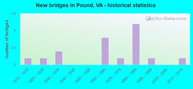
- New bridges - historical statistics
- 11910-1919
- 11920-1929
- 21930-1939
- 41960-1969
- 11970-1979
- 61980-1989
- 11990-1999
- 12010-2019

- Reconstructed bridges - Historical Statistics
- 11940-1949
- 01950-1959
- 01960-1969
- 11970-1979
- 11980-1989
- 01990-1999
- 32000-2009
- 12010-2019


- Bridge Condition - Deck
- 50.0%Good
- 28.6%Satisfactory
- 21.4%Fair

- Bridge Condition - Superstructure
- 57.1%Good
- 21.4%Satisfactory
- 21.4%Fair

- Bridge Condition - Substructure
- 57.1%Good
- 35.7%Satisfactory
- 7.1%Fair

- Bridge Condition - Channel
- 23.5%Very good
- 5.9%Good
- 41.2%Satisfactory
- 29.4%Fair

- Bridge Condition - Culverts
- 33.3%Good
- 33.3%Satisfactory
- 33.3%Fair
Find on map >> Show street view
Structure Number: 19246, Location: .01M TO 83 &.05M TO T-749 (Lat: 37.122442, Lng: -82.600439), Route carried "on" structure: Business US 23, Year Built: 1989, Status: Open, Structure Length: 4.05m (13.29ft), Average Daily Traffic: 5,203 (year 2020), Truck Traffic: 3%, Average Future Daily Traffic: 5,723 (year 2040), Design Load: HS 20+Mod, Features Intersected: POUND RIVER, Facility Carried by Structure: INDIAN CREEK RD.
Minimum Vertical Clearance: 30+ m (98+ ft), Kilometerpoint: 96.291, Lanes on structure: 2, Base Highway Network: Yes, Owner: State Highway Agency, Approaching Roadway Width: 7.9m (25.9ft), Skew: 4 degrees, Material/Design: Steel, Design/Construction: Stringer/Multi-beam, Number Of Spans In Main Unit: 2, Length of Maximum Span: 19.8m (65.0ft), Curb or Sidewalk Widths: Left: 1.5m (4.9ft), Right: 0.0m, Curb-To-Curb Width: 9.2m (30.2ft), Out-to-Out Width: 11.3m (37.1ft)
Condition: Deck: Satisfactory, Superstructure: Satisfactory, Substructure: Satisfactory, Channel: Very good, Operating Rating: 88.9 metric tons, Method Used To Determine Operating Rating: Load and Resistance Factor (LRFR), Inventory Rating: 68.9 metric tons, Method Used To Determine Inventory Rating: Load and Resistance Factor (LRFR), Structural Evaluation: Equal to present minimum criteria, Deck Geometry: High priority of corrective action, Waterway Adequacy: Equal to present desirable criteria, Approach Roadway Alignment: Equal to present desirable criteria, Length Of Structure Improvement: 4.05m (13.29ft), Designated Inspection Frequency: Every 24 months, Inspection Date: August 2021, Deck Structure Type: Concrete Cast-file-Place, Wearing Surface/Protective System: Deck Protection: Epoxy Coated Reinforcing
Find on map >> Show street view
Structure Number: 1927, Location: 6.6523B@WISE .9023B@POUND (Lat: 37.086658, Lng: -82.598675), Route carried "on" structure: Business US 23, Year Built: 1968, Year Reconstructed: 1994, Status: Open, Structure Length: 1.10m (3.61ft), Average Daily Traffic: 11,182 (year 2020), Truck Traffic: 4%, Average Future Daily Traffic: 12,967 (year 2040), Design Load: HS 20, Features Intersected: INDIAN CREEK, Facility Carried by Structure: ORBY CANTRELL HWY.
Minimum Vertical Clearance: 30+ m (98+ ft), Kilometerpoint: 87.629, Lanes on structure: 4, Base Highway Network: Yes, Owner: State Highway Agency, Approaching Roadway Width: 9.1m (29.9ft), Skew: 14 degrees, Material/Design: Concrete, Design/Construction: Culvert, Number Of Spans In Main Unit: 3, Length of Maximum Span: 3.0m (9.8ft)
Condition: Channel: Fair, Culverts: Fair, Operating Rating: 44.5 metric tons, Method Used To Determine Operating Rating: Field evaluation and documented engineering judgment, Inventory Rating: 32.7 metric tons, Method Used To Determine Inventory Rating: Field evaluation and documented engineering judgment, Structural Evaluation: Somewhat better than minimum adequacy, Waterway Adequacy: Better than present minimum criteria, Approach Roadway Alignment: Better than present minimum criteria, Designated Inspection Frequency: Every 24 months, Inspection Date: January 2021
Find on map >> Show street view
Structure Number: 19277, Location: 1.79MTO23BPOUND&.03MTO671 (Lat: 37.116614, Lng: -82.617731), Route carried "on" structure: US 23, Year Built: 1967, Status: Open, Structure Length: 1.28m (4.20ft), Average Daily Traffic: 6,376 (year 2020), Truck Traffic: 4%, Average Future Daily Traffic: 8,926 (year 2040), Design Load: H 20, Features Intersected: SF POUND RV, Facility Carried by Structure: ORBY CANTRELL HWY
Minimum Vertical Clearance: 30+ m (98+ ft), Kilometerpoint: 91.991, Lanes on structure: 4, Base Highway Network: Yes, Owner: State Highway Agency, Approaching Roadway Width: 29.3m (96.1ft), Material/Design: Concrete, Design/Construction: Culvert, Number Of Spans In Main Unit: 4, Length of Maximum Span: 3.0m (9.8ft)
Condition: Channel: Fair, Culverts: Good, Operating Rating: 44.5 metric tons, Method Used To Determine Operating Rating: Field evaluation and documented engineering judgment, Inventory Rating: 32.7 metric tons, Method Used To Determine Inventory Rating: Field evaluation and documented engineering judgment, Structural Evaluation: Better than present minimum criteria, Waterway Adequacy: Better than present minimum criteria, Approach Roadway Alignment: Better than present minimum criteria, Length Of Structure Improvement: 1.28m (4.20ft), Designated Inspection Frequency: Every 24 months, Inspection Date: January 2021, Bridge Improvement Cost: $30,000, Roadway Improvement Cost: $10,000, Total Project Cost: $50,000 ( Estimate for 2019)
Find on map >> Show street view
Structure Number: 19278, Location: .0MTO23B@POUND&1.8MTO671 (Lat: 37.100811, Lng: -82.599669), Route carried "on" structure: US 23, Year Built: 1967, Status: Open, Structure Length: 1.34m (4.40ft), Average Daily Traffic: 6,376 (year 2020), Truck Traffic: 4%, Average Future Daily Traffic: 8,926 (year 2040), Design Load: H 20, Features Intersected: INDIAN CREEK, Facility Carried by Structure: ORBY CANTRELL HWY.
Minimum Vertical Clearance: 30+ m (98+ ft), Kilometerpoint: 89.206, Lanes on structure: 4, Base Highway Network: Yes, Owner: State Highway Agency, Approaching Roadway Width: 23.2m (76.1ft), Skew: 4 degrees, Material/Design: Concrete, Design/Construction: Culvert, Number Of Spans In Main Unit: 3, Length of Maximum Span: 4.3m (14.1ft)
Condition: Channel: Fair, Culverts: Satisfactory, Operating Rating: 44.5 metric tons, Method Used To Determine Operating Rating: Field evaluation and documented engineering judgment, Inventory Rating: 32.7 metric tons, Method Used To Determine Inventory Rating: Field evaluation and documented engineering judgment, Structural Evaluation: Equal to present minimum criteria, Waterway Adequacy: Better than present minimum criteria, Approach Roadway Alignment: Better than present minimum criteria, Length Of Structure Improvement: 1.34m (4.40ft), Designated Inspection Frequency: Every 24 months, Inspection Date: January 2021, Bridge Improvement Cost: $50,000, Roadway Improvement Cost: $10,000, Total Project Cost: $90,000 ( Estimate for 2018)
Find on map >> Show street view
Structure Number: 19343, Location: 4.2MTODIC CL&.06MTO23BUS (Lat: 37.124028, Lng: -82.600889), Route carried "on" structure: State highway 83, Year Built: 1930, Year Reconstructed: 2008, Status: Open, Structure Length: 5.33m (17.49ft), Average Daily Traffic: 4,913 (year 2020), Truck Traffic: 3%, Average Future Daily Traffic: 5,464 (year 2040), Design Load: HS 20+Mod, Features Intersected: POUND RIVER, Facility Carried by Structure: CLINTWOOD HWY.
Minimum Vertical Clearance: 30+ m (98+ ft), Kilometerpoint: 0.043, Lanes on structure: 2, Owner: State Highway Agency, Approaching Roadway Width: 7.3m (24.0ft), Material/Design: Concrete, Design/Construction: Arch - Deck, Number Of Spans In Main Unit: 1, Number Of Approach Spans: 4, Length of Maximum Span: 32.0m (105.0ft), Curb or Sidewalk Widths: Left: 0.0m, Right: 1.5m (4.9ft), Curb-To-Curb Width: 7.3m (24.0ft), Out-to-Out Width: 9.3m (30.5ft)
Condition: Deck: Good, Superstructure: Good, Substructure: Satisfactory, Channel: Very good, Operating Rating: 38.1 metric tons, Method Used To Determine Operating Rating: Load and Resistance Factor (LRFR), Inventory Rating: 29.0 metric tons, Method Used To Determine Inventory Rating: Load and Resistance Factor (LRFR), Structural Evaluation: Equal to present minimum criteria, Deck Geometry: High priority of replacement, Waterway Adequacy: Better than present minimum criteria, Approach Roadway Alignment: Better than present minimum criteria, Length Of Structure Improvement: 5.33m (17.49ft), Designated Inspection Frequency: Every 24 months, Inspection Date: November 2020, Deck Structure Type: Concrete Cast-file-Place, Wearing Surface/Protective System: Deck Protection: Epoxy Coated Reinforcing
Find on map >> Show street view
Structure Number: 19412, Location: 0.0M TO 633& .05 TO 840 (Lat: 37.108817, Lng: -82.585014), Route carried "on" structure: County highway 632, Year Built: 1983, Status: Open, Structure Length: 1.04m (3.41ft), Average Daily Traffic: 891 (year 2016), Average Future Daily Traffic: 998 (year 2040), Design Load: HS 20, Features Intersected: MCFALL FORK, Facility Carried by Structure: HIGHLAND AVE.
Minimum Vertical Clearance: 30+ m (98+ ft), Kilometerpoint: 4.335, Lanes on structure: 2, Owner: State Highway Agency, Approaching Roadway Width: 6.4m (21.0ft), Material/Design: Concrete, Design/Construction: Slab, Number Of Spans In Main Unit: 1, Length of Maximum Span: 9.8m (32.2ft), Curb-To-Curb Width: 7.3m (24.0ft), Out-to-Out Width: 7.9m (25.9ft)
Condition: Deck: Satisfactory, Superstructure: Satisfactory, Substructure: Good, Channel: Satisfactory, Operating Rating: 89.8 metric tons, Method Used To Determine Operating Rating: Load and Resistance Factor (LRFR), Inventory Rating: 78.0 metric tons, Method Used To Determine Inventory Rating: Load and Resistance Factor (LRFR), Structural Evaluation: Equal to present minimum criteria, Deck Geometry: Meets minimum limits, Waterway Adequacy: Better than present minimum criteria, Approach Roadway Alignment: Better than present minimum criteria, Designated Inspection Frequency: Every 24 months, Inspection Date: August 2021, Deck Structure Type: Concrete Cast-file-Place
Find on map >> Show street view
Structure Number: 19413, Location: .02M TO 693 & .08M TO 23B (Lat: 37.117208, Lng: -82.598369), Route carried "on" structure: County highway 633, Year Built: 1921, Year Reconstructed: 2010, Status: Open, Structure Length: 0.98m (3.22ft), Average Daily Traffic: 589 (year 2016), Truck Traffic: 2%, Average Future Daily Traffic: 744 (year 2040), Design Load: HL 93, Features Intersected: INDIAN CREEK, Facility Carried by Structure: BOLD CAMP RD.
Minimum Vertical Clearance: 30+ m (98+ ft), Kilometerpoint: 0.023, Lanes on structure: 1, Owner: State Highway Agency, Approaching Roadway Width: 4.0m (13.1ft), Material/Design: Concrete, Design/Construction: Slab, Number Of Spans In Main Unit: 1, Length of Maximum Span: 8.8m (28.9ft), Curb-To-Curb Width: 4.5m (14.8ft), Out-to-Out Width: 5.4m (17.7ft)
Condition: Deck: Good, Superstructure: Good, Substructure: Good, Channel: Satisfactory, Operating Rating: 78.9 metric tons, Method Used To Determine Operating Rating: Load and Resistance Factor (LRFR), Inventory Rating: 60.8 metric tons, Method Used To Determine Inventory Rating: Load and Resistance Factor (LRFR), Structural Evaluation: Better than present minimum criteria, Deck Geometry: High priority of replacement, Waterway Adequacy: Better than present minimum criteria, Approach Roadway Alignment: Better than present minimum criteria, Length Of Structure Improvement: 1.04m (3.41ft), Designated Inspection Frequency: Every 24 months, Inspection Date: November 2020, Deck Structure Type: Concrete Cast-file-Place, Wearing Surface/Protective System: Deck Protection: Epoxy Coated Reinforcing
Find on map >> Show street view
Structure Number: 19414, Location: 1.17M TO 23B & .0M TO 632 (Lat: 37.108739, Lng: -82.585131), Route carried "on" structure: County highway 633, Year Built: 1932, Year Reconstructed: 1951, Status: Posted for load, Structure Length: 0.67m (2.20ft), Average Daily Traffic: 779 (year 2020), Truck Traffic: 3%, Average Future Daily Traffic: 857 (year 2040), Design Load: H 20, Features Intersected: MULLINS FORK, Facility Carried by Structure: BOLD CAMP RD.
Minimum Vertical Clearance: 30+ m (98+ ft), Kilometerpoint: 2.037, Lanes on structure: 2, Owner: State Highway Agency, Approaching Roadway Width: 6.1m (20.0ft), Material/Design: Concrete, Design/Construction: Slab, Number Of Spans In Main Unit: 1, Length of Maximum Span: 6.1m (20.0ft), Curb or Sidewalk Widths: Left: 0.2m (0.7ft), Right: 0.2m (0.7ft), Curb-To-Curb Width: 7.3m (24.0ft), Out-to-Out Width: 8.4m (27.6ft)
Condition: Deck: Fair, Superstructure: Fair, Substructure: Satisfactory, Channel: Satisfactory, Operating Rating: 27.2 metric tons, Method Used To Determine Operating Rating: Load Factor (LF), Inventory Rating: 16.3 metric tons, Method Used To Determine Inventory Rating: Load Factor (LF), Structural Evaluation: Meets minimum limits, Deck Geometry: Meets minimum limits, Waterway Adequacy: Better than present minimum criteria, Approach Roadway Alignment: Better than present minimum criteria, Length Of Structure Improvement: 0.67m (2.20ft), Designated Inspection Frequency: Every 24 months, Inspection Date: October 2021, Bridge Improvement Cost: $20,000, Roadway Improvement Cost: $15,000, Total Project Cost: $46,000 ( Estimate for 2017), Deck Structure Type: Concrete Cast-file-Place, Wearing Surface/Protective System: Wearing Surface: Bituminous
Find on map >> Show street view
Structure Number: 19445, Location: .03M TO 23B & .05M TO 700 (Lat: 37.123364, Lng: -82.613569), Route carried "on" structure: County highway 671, Year Built: 1983, Status: Open, Structure Length: 0.98m (3.22ft), Average Daily Traffic: 989 (year 2020), Truck Traffic: 3%, Average Future Daily Traffic: 1,088 (year 2040), Design Load: HS 20+Mod, Features Intersected: POUND RIVER, Facility Carried by Structure: SOUTH FORK RD.
Minimum Vertical Clearance: 30+ m (98+ ft), Kilometerpoint: 16.885, Lanes on structure: 2, Owner: State Highway Agency, Approaching Roadway Width: 7.0m (23.0ft), Material/Design: Prestressed concrete, Design/Construction: Box Beam or Girders - Multiple, Number Of Spans In Main Unit: 1, Length of Maximum Span: 9.1m (29.9ft), Curb-To-Curb Width: 7.6m (24.9ft), Out-to-Out Width: 8.2m (26.9ft)
Condition: Deck: Satisfactory, Superstructure: Satisfactory, Substructure: Satisfactory, Channel: Satisfactory, Operating Rating: 62.6 metric tons, Method Used To Determine Operating Rating: Load and Resistance Factor (LRFR), Inventory Rating: 48.1 metric tons, Method Used To Determine Inventory Rating: Load and Resistance Factor (LRFR), Structural Evaluation: Equal to present minimum criteria, Deck Geometry: Meets minimum limits, Waterway Adequacy: Better than present minimum criteria, Approach Roadway Alignment: Better than present minimum criteria, Length Of Structure Improvement: 0.98m (3.22ft), Designated Inspection Frequency: Every 24 months, Inspection Date: October 2021, Bridge Improvement Cost: $50,000, Roadway Improvement Cost: $17,000, Total Project Cost: $87,000 ( Estimate for 2018), Deck Structure Type: Other, Wearing Surface/Protective System: Wearing Surface: Bituminous
Find on map >> Show street view
Structure Number: 19451, Location: .98MTOENDMAINT&.57MTO 671 (Lat: 37.086936, Lng: -82.626703), Route carried "on" structure: County highway 679, Year Built: 1987, Status: Open, Structure Length: 0.98m (3.22ft), Average Daily Traffic: 73 (year 2016), Average Future Daily Traffic: 82 (year 2040), Design Load: HS 20+Mod, Features Intersected: GLADY FORK, Facility Carried by Structure: GLADY FORK RD.
Minimum Vertical Clearance: 30+ m (98+ ft), Kilometerpoint: 1.567, Lanes on structure: 2, Owner: State Highway Agency, Approaching Roadway Width: 5.5m (18.0ft), Skew: 3 degrees, Material/Design: Concrete, Design/Construction: Slab, Number Of Spans In Main Unit: 1, Length of Maximum Span: 9.1m (29.9ft), Curb-To-Curb Width: 7.6m (24.9ft), Out-to-Out Width: 8.6m (28.2ft)
Condition: Deck: Good, Superstructure: Good, Substructure: Good, Channel: Satisfactory, Operating Rating: 65.3 metric tons, Method Used To Determine Operating Rating: Load and Resistance Factor (LRFR), Inventory Rating: 50.8 metric tons, Method Used To Determine Inventory Rating: Load and Resistance Factor (LRFR), Structural Evaluation: Better than present minimum criteria, Deck Geometry: Equal to present minimum criteria, Waterway Adequacy: Better than present minimum criteria, Approach Roadway Alignment: Better than present minimum criteria, Designated Inspection Frequency: Every 24 months, Inspection Date: December 2021, Deck Structure Type: Concrete Cast-file-Place
Find on map >> Show street view
Structure Number: 19452, Location: 0.02 FR. 671; 1.48 TO END (Lat: 37.090886, Lng: -82.630153), Route carried "on" structure: County highway 679, Year Built: 1983, Status: Open, Structure Length: 1.68m (5.51ft), Average Daily Traffic: 73 (year 2016), Average Future Daily Traffic: 82 (year 2040), Design Load: HS 20+Mod, Features Intersected: POUND RIVER, Facility Carried by Structure: GLADY FORK ROAD
Minimum Vertical Clearance: 30+ m (98+ ft), Kilometerpoint: 2.365, Lanes on structure: 2, Owner: State Highway Agency, Approaching Roadway Width: 4.9m (16.1ft), Skew: 2 degrees, Material/Design: Prestressed concrete, Design/Construction: Box Beam or Girders - Multiple, Number Of Spans In Main Unit: 1, Length of Maximum Span: 16.2m (53.1ft), Curb-To-Curb Width: 6.7m (22.0ft), Out-to-Out Width: 7.3m (24.0ft)
Condition: Deck: Good, Superstructure: Good, Substructure: Good, Channel: Very good, Operating Rating: 89.8 metric tons, Method Used To Determine Operating Rating: Load and Resistance Factor (LRFR), Inventory Rating: 70.8 metric tons, Method Used To Determine Inventory Rating: Load and Resistance Factor (LRFR), Structural Evaluation: Better than present minimum criteria, Deck Geometry: Somewhat better than minimum adequacy, Waterway Adequacy: Better than present minimum criteria, Approach Roadway Alignment: Better than present minimum criteria, Designated Inspection Frequency: Every 24 months, Inspection Date: January 2022, Deck Structure Type: Other, Wearing Surface/Protective System: Wearing Surface: Bituminous
Find on map >> Show street view
Structure Number: 19461, Location: .40MTOENDSTMAINT&.10MTO23 (Lat: 37.096772, Lng: -82.601531), Route carried "on" structure: County highway 689, Year Built: 1961, Year Reconstructed: 1983, Status: Open, Structure Length: 0.82m (2.69ft), Average Daily Traffic: 85 (year 2016), Average Future Daily Traffic: 95 (year 2040), Design Load: HS 20+Mod, Features Intersected: INDIAN CREEK, Facility Carried by Structure: GILLIAM HOLLOW RD.
Minimum Vertical Clearance: 30+ m (98+ ft), Kilometerpoint: 0.636, Lanes on structure: 2, Owner: State Highway Agency, Approaching Roadway Width: 5.2m (17.1ft), Skew: 1 degrees, Material/Design: Concrete, Design/Construction: Slab, Number Of Spans In Main Unit: 1, Length of Maximum Span: 7.3m (24.0ft), Curb-To-Curb Width: 7.3m (24.0ft), Out-to-Out Width: 7.9m (25.9ft)
Condition: Deck: Fair, Superstructure: Fair, Substructure: Satisfactory, Channel: Fair, Operating Rating: 89.8 metric tons, Method Used To Determine Operating Rating: Load and Resistance Factor (LRFR), Inventory Rating: 87.1 metric tons, Method Used To Determine Inventory Rating: Load and Resistance Factor (LRFR), Structural Evaluation: Somewhat better than minimum adequacy, Deck Geometry: Equal to present minimum criteria, Waterway Adequacy: Better than present minimum criteria, Approach Roadway Alignment: Better than present minimum criteria, Designated Inspection Frequency: Every 24 months, Inspection Date: June 2021, Deck Structure Type: Concrete Cast-file-Place
Find on map >> Show street view
Structure Number: 19463, Location: 1.2M TO 633 & .23M TO 23B (Lat: 37.102447, Lng: -82.597739), Route carried "on" structure: County highway 693, Year Built: 1915, Year Reconstructed: 2007, Status: Open, Structure Length: 1.25m (4.10ft), Average Daily Traffic: 233 (year 2016), Average Future Daily Traffic: 345 (year 2040), Design Load: HS 20+Mod, Features Intersected: INDIAN CREEK, Facility Carried by Structure: OLD INDIAN CK. RD.
Minimum Vertical Clearance: 30+ m (98+ ft), Kilometerpoint: 0.228, Lanes on structure: 1, Owner: State Highway Agency, Approaching Roadway Width: 4.0m (13.1ft), Material/Design: Steel, Design/Construction: Stringer/Multi-beam, Number Of Spans In Main Unit: 1, Length of Maximum Span: 11.4m (37.4ft), Curb-To-Curb Width: 3.6m (11.8ft), Out-to-Out Width: 3.7m (12.1ft)
Condition: Deck: Satisfactory, Superstructure: Good, Substructure: Good, Channel: Satisfactory, Operating Rating: 49.9 metric tons, Method Used To Determine Operating Rating: Load and Resistance Factor (LRFR), Inventory Rating: 39.0 metric tons, Method Used To Determine Inventory Rating: Load and Resistance Factor (LRFR), Structural Evaluation: Better than present minimum criteria, Deck Geometry: High priority of replacement, Waterway Adequacy: Better than present minimum criteria, Approach Roadway Alignment: Better than present minimum criteria, Length Of Structure Improvement: 1.34m (4.40ft), Designated Inspection Frequency: Every 24 months, Inspection Date: November 2020, Deck Structure Type: Corrugated Steel, Wearing Surface/Protective System: Wearing Surface: Bituminous
Find on map >> Show street view
Structure Number: 19465, Location: .01MTO671&.89MTOENDMAINT. (Lat: 37.122936, Lng: -82.613611), Route carried "on" structure: County highway 700, Year Built: 1975, Year Reconstructed: 2014, Status: Open, Structure Length: 0.91m (2.99ft), Average Daily Traffic: 390 (year 2016), Average Future Daily Traffic: 399 (year 2040), Design Load: HL 93, Features Intersected: POUND RIVER, Facility Carried by Structure: BOGGS TOWN RD.
Minimum Vertical Clearance: 30+ m (98+ ft), Kilometerpoint: 1.117, Lanes on structure: 2, Owner: State Highway Agency, Approaching Roadway Width: 5.5m (18.0ft), Skew: 1 degrees, Material/Design: Concrete, Design/Construction: Slab, Number Of Spans In Main Unit: 1, Length of Maximum Span: 8.5m (27.9ft), Curb-To-Curb Width: 5.5m (18.0ft), Out-to-Out Width: 6.7m (22.0ft)
Condition: Deck: Good, Superstructure: Good, Substructure: Good, Channel: Good, Operating Rating: 89.8 metric tons, Method Used To Determine Operating Rating: Load and Resistance Factor (LRFR), Inventory Rating: 75.3 metric tons, Method Used To Determine Inventory Rating: Load and Resistance Factor (LRFR), Structural Evaluation: Better than present minimum criteria, Deck Geometry: High priority of corrective action, Waterway Adequacy: Better than present minimum criteria, Approach Roadway Alignment: Better than present minimum criteria, Length Of Structure Improvement: 0.98m (3.22ft), Designated Inspection Frequency: Every 24 months, Inspection Date: September 2020, Deck Structure Type: Concrete Precast Panels, Wearing Surface/Protective System: Wearing Surface: Bituminous
Find on map >> Show street view
Structure Number: 19478, Location: .52MTOPOUNDCL&.03M TO83 (Lat: 37.124797, Lng: -82.600383), Route carried "on" structure: County highway 768, Year Built: 1984, Status: Posted for load, Structure Length: 6.22m (20.41ft), Average Daily Traffic: 515 (year 2016), Average Future Daily Traffic: 577 (year 2040), Design Load: HS 20+Mod, Features Intersected: POUND RIVER, Facility Carried by Structure: OLDMILL VILLAGE RD
Minimum Vertical Clearance: 30+ m (98+ ft), Kilometerpoint: 0.180, Lanes on structure: 2, Owner: State Highway Agency, Approaching Roadway Width: 5.8m (19.0ft), Skew: 2 degrees, Material/Design: Steel, Design/Construction: Girder and Floorbeam System, Number Of Spans In Main Unit: 2, Length of Maximum Span: 31.1m (102.0ft), Curb or Sidewalk Widths: Left: 1.1m (3.6ft), Right: 0.0m, Curb-To-Curb Width: 6.4m (21.0ft), Out-to-Out Width: 6.4m (21.0ft)
Condition: Deck: Fair, Superstructure: Fair, Substructure: Fair, Channel: Satisfactory, Operating Rating: 45.4 metric tons, Method Used To Determine Operating Rating: Load Factor (LF), Inventory Rating: 27.2 metric tons, Method Used To Determine Inventory Rating: Load Factor (LF), Structural Evaluation: Somewhat better than minimum adequacy, Deck Geometry: High priority of corrective action, Waterway Adequacy: Equal to present desirable criteria, Approach Roadway Alignment: Better than present minimum criteria, Length Of Structure Improvement: 6.22m (20.41ft), Designated Inspection Frequency: Every 12 months, Critical Feature Inspection Frequency: Every 12 months, Inspection Date: November 2021, Critical Feature Inspection Date: November 2021, Bridge Improvement Cost: $200,000, Roadway Improvement Cost: $25,000, Total Project Cost: $293,000 ( Estimate for 2019), Deck Structure Type: Concrete Cast-file-Place
Find on map >> Show street view
Structure Number: 25271, Location: .05MTO671 &.25MTOENDMAINT (Lat: 37.109439, Lng: -82.617450), Route carried "on" structure: County highway 714, Year Built: 1998, Status: Open, Structure Length: 1.65m (5.41ft), Average Daily Traffic: 60 (year 2016), Average Future Daily Traffic: 84 (year 2040), Design Load: HS 20+Mod, Features Intersected: SOUTH FORK POUND RIVER, Facility Carried by Structure: DRULU ROAD
Minimum Vertical Clearance: 30+ m (98+ ft), Kilometerpoint: 0.080, Lanes on structure: 2, Owner: State Highway Agency, Approaching Roadway Width: 6.4m (21.0ft), Skew: 3 degrees, Material/Design: Concrete, Design/Construction: Slab, Number Of Spans In Main Unit: 2, Length of Maximum Span: 8.2m (26.9ft), Curb-To-Curb Width: 7.3m (24.0ft), Out-to-Out Width: 7.9m (25.9ft)
Condition: Deck: Good, Superstructure: Good, Substructure: Good, Channel: Fair, Operating Rating: 89.8 metric tons, Method Used To Determine Operating Rating: Load and Resistance Factor (LRFR), Inventory Rating: 85.3 metric tons, Method Used To Determine Inventory Rating: Load and Resistance Factor (LRFR), Structural Evaluation: Better than present minimum criteria, Deck Geometry: Equal to present minimum criteria, Waterway Adequacy: Better than present minimum criteria, Approach Roadway Alignment: Better than present minimum criteria, Designated Inspection Frequency: Every 24 months, Inspection Date: May 2020, Deck Structure Type: Concrete Cast-file-Place, Wearing Surface/Protective System: Deck Protection: Epoxy Coated Reinforcing
Find on map >> Show street view
Structure Number: 30582, Location: 0.0 M TO 693 0.05M TO 633 (Lat: 37.118794, Lng: -82.598158), Route carried "on" structure: Business US 23, Year Built: 2017, Status: Open, Structure Length: 4.11m (13.48ft), Average Daily Traffic: 2,601 (year 2020), Truck Traffic: 3%, Average Future Daily Traffic: 3,643 (year 2040), Design Load: HL 93, Features Intersected: INDIAN CREEK, Facility Carried by Structure: Indian Creek Rd
Minimum Vertical Clearance: 30+ m (98+ ft), Kilometerpoint: 0.000, Lanes on structure: 1, Owner: State Highway Agency, Approaching Roadway Width: 7.9m (25.9ft), Skew: 3 degrees, Material/Design: Prestressed concrete continuous, Design/Construction: Stringer/Multi-beam, Number Of Spans In Main Unit: 2, Length of Maximum Span: 23.7m (77.8ft), Curb or Sidewalk Widths: Left: 1.8m (5.9ft), Right: 0.0m, Curb-To-Curb Width: 11.0m (36.1ft), Out-to-Out Width: 11.5m (37.7ft)
Condition: Deck: Good, Superstructure: Good, Substructure: Good, Channel: Very good, Operating Rating: 68.0 metric tons, Method Used To Determine Operating Rating: Load and Resistance Factor (LRFR), Inventory Rating: 50.8 metric tons, Method Used To Determine Inventory Rating: Load and Resistance Factor (LRFR), Structural Evaluation: Better than present minimum criteria, Deck Geometry: Somewhat better than minimum adequacy, Waterway Adequacy: Equal to present desirable criteria, Approach Roadway Alignment: Equal to present desirable criteria, Designated Inspection Frequency: Every 24 months, Inspection Date: May 2021, Deck Structure Type: Concrete Cast-file-Place, Wearing Surface/Protective System: Deck Protection: Other Coated Reinforcing