Bridge Statistics for Powderville, South Carolina (SC)
Condition, Traffic, Stress, Structural Evaluation, Project Costs
- National Bridge Inventory (NBI) Statistics
- 12Number of bridges
- 138ft / 42.1mTotal length
- $3,303,000Total costs
- 36,250Total average daily traffic
- 1,601Total average daily truck traffic
- National Bridge Inventory (NBI) Registered Bridges for Powderville
- No street view available for this location
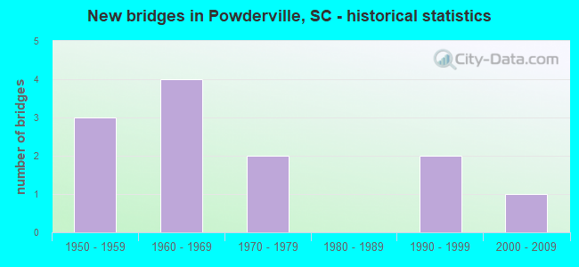
- New bridges - historical statistics
- 31950-1959
- 41960-1969
- 21970-1979
- 21990-1999
- 12000-2009


- Bridge Condition - Deck
- 27.3%Very good
- 9.1%Good
- 54.5%Satisfactory
- 9.1%Fair

- Bridge Condition - Superstructure
- 27.3%Very good
- 9.1%Good
- 45.5%Satisfactory
- 9.1%Fair
- 9.1%Poor

- Bridge Condition - Substructure
- 27.3%Very good
- 9.1%Good
- 36.4%Satisfactory
- 27.3%Fair

- Bridge Condition - Channel
- 27.3%Very good
- 54.5%Good
- 9.1%Satisfactory
- 9.1%Fair
Find on map >> Show street view
Structure Number: 1786, Location: 19.7 MI NE OF ANDERSON (Lat: 34.779247, Lng: -82.530453), Route carried "on" structure: County highway 2138, Year Built: 1951, Status: Posted for load, Structure Length: 2.07m (6.79ft), Average Daily Traffic: 150 (year 2021), Truck Traffic: 5%, Average Future Daily Traffic: 192 (year 2041), Design Load: H 10, Features Intersected: MIDDLE BRANCH CR
Minimum Vertical Clearance: 30+ m (98+ ft), Kilometerpoint: 0.557, Lanes on structure: 2, Owner: County Highway Agency, Approaching Roadway Width: 5.8m (19.0ft), Skew: 1 degrees, Material/Design: Steel, Design/Construction: Stringer/Multi-beam, Number Of Spans In Main Unit: 3, Length of Maximum Span: 7.0m (23.0ft), Curb-To-Curb Width: 7.4m (24.3ft), Out-to-Out Width: 7.9m (25.9ft)
Condition: Deck: Satisfactory, Superstructure: Satisfactory, Substructure: Fair, Channel: Very good, Operating Rating: 14.3 metric tons, Method Used To Determine Operating Rating: Load and Resistance Factor Rating (LRFR) rating reported by rating factor(RF) method using HL-93 loadings, Inventory Rating: 11.0 metric tons, Method Used To Determine Inventory Rating: Load and Resistance Factor Rating (LRFR) rating reported by rating factor(RF) method using HL-93 loadings, Structural Evaluation: Meets minimum limits, Deck Geometry: Somewhat better than minimum adequacy, Waterway Adequacy: Equal to present desirable criteria, Approach Roadway Alignment: Better than present minimum criteria, Length Of Structure Improvement: 2.07m (6.79ft), Designated Inspection Frequency: Every 24 months, Inspection Date: November 2020, Deck Structure Type: Concrete Cast-file-Place, Wearing Surface/Protective System: Wearing Surface: Bituminous
Find on map >> Show street view
Structure Number: 1994, Location: 15 MI SE OF EASLEY (Lat: 34.796578, Lng: -82.533628), Route carried "on" structure: County highway 480, Year Built: 1954, Status: Posted for load, Structure Length: 0.64m (2.10ft), Average Daily Traffic: 200 (year 2020), Average Future Daily Traffic: 256 (year 2040), Design Load: H 10, Features Intersected: BRUSHY CREEK
Minimum Vertical Clearance: 30+ m (98+ ft), Kilometerpoint: 1.770, Lanes on structure: 2, Owner: County Highway Agency, Approaching Roadway Width: 5.5m (18.0ft), Material/Design: Steel, Design/Construction: Stringer/Multi-beam, Number Of Spans In Main Unit: 1, Length of Maximum Span: 6.4m (21.0ft), Curb-To-Curb Width: 7.6m (24.9ft), Out-to-Out Width: 8.4m (27.6ft)
Condition: Deck: Satisfactory, Superstructure: Fair, Substructure: Satisfactory, Channel: Fair, Operating Rating: 8.4 metric tons, Method Used To Determine Operating Rating: Load and Resistance Factor Rating (LRFR) rating reported by rating factor(RF) method using HL-93 loadings, Inventory Rating: 6.5 metric tons, Method Used To Determine Inventory Rating: Load and Resistance Factor Rating (LRFR) rating reported by rating factor(RF) method using HL-93 loadings, Structural Evaluation: High priority of replacement, Deck Geometry: Somewhat better than minimum adequacy, Waterway Adequacy: Better than present minimum criteria, Approach Roadway Alignment: Better than present minimum criteria, Bridge Posting: Required (Relationship of Operating Rating to Maximum Legal Load: > 39.9% below), Length Of Structure Improvement: 1.25m (4.10ft), Designated Inspection Frequency: Every 5 months, Inspection Date: November 2021, Bridge Improvement Cost: $110,000, Roadway Improvement Cost: $28,000, Total Project Cost: $165,000 ( Estimate for 2021), Deck Structure Type: Concrete Cast-file-Place, Wearing Surface/Protective System: Wearing Surface: Bituminous
Find on map >> Show street view
Structure Number: 2115, Location: 9.3MI NW OF WILLIAMSTON (Lat: 34.754992, Lng: -82.499439), Route carried "on" structure: State highway 81, Year Built: 1955, Status: Open, Structure Length: 3.66m (12.01ft), Average Daily Traffic: 6,900 (year 2020), Truck Traffic: 4%, Average Future Daily Traffic: 8,763 (year 2040), Design Load: HS 15, Features Intersected: BIG BRUSHY CREEK
Minimum Vertical Clearance: 30+ m (98+ ft), Kilometerpoint: 65.738, Lanes on structure: 2, Owner: State Highway Agency, Approaching Roadway Width: 6.7m (22.0ft), Material/Design: Concrete, Design/Construction: Tee Beam, Number Of Spans In Main Unit: 4, Length of Maximum Span: 9.1m (29.9ft), Curb-To-Curb Width: 8.5m (27.9ft), Out-to-Out Width: 9.5m (31.2ft)
Condition: Deck: Satisfactory, Superstructure: Satisfactory, Substructure: Fair, Channel: Satisfactory, Operating Rating: 36.9 metric tons, Method Used To Determine Operating Rating: Load and Resistance Factor Rating (LRFR) rating reported by rating factor(RF) method using HL-93 loadings, Inventory Rating: 28.5 metric tons, Method Used To Determine Inventory Rating: Load and Resistance Factor Rating (LRFR) rating reported by rating factor(RF) method using HL-93 loadings, Structural Evaluation: Somewhat better than minimum adequacy, Deck Geometry: High priority of replacement, Waterway Adequacy: Equal to present minimum criteria, Approach Roadway Alignment: Equal to present desirable criteria, Bridge Posting: Required (Relationship of Operating Rating to Maximum Legal Load: 0.1 - 9.9% below), Length Of Structure Improvement: 4.54m (14.90ft), Designated Inspection Frequency: Every 24 months, Inspection Date: December 2021, Bridge Improvement Cost: $223,000, Roadway Improvement Cost: $56,000, Total Project Cost: $335,000 ( Estimate for 2021), Deck Structure Type: Concrete Cast-file-Place, Wearing Surface/Protective System: Wearing Surface: Bituminous
Find on map >> Show street view
Structure Number: 2117, Location: 11.8MI NW WILLIAMSTON (Lat: 34.787850, Lng: -82.534294), Route carried "on" structure: State highway 94, Year Built: 2004, Status: Open, Structure Length: 3.05m (10.01ft), Average Daily Traffic: 5,100 (year 2020), Truck Traffic: 2%, Average Future Daily Traffic: 7,803 (year 2040), Design Load: HS 20, Features Intersected: MIDDLE BRUSHY CREEK
Minimum Vertical Clearance: 30+ m (98+ ft), Kilometerpoint: 1.056, Lanes on structure: 2, Owner: State Highway Agency, Approaching Roadway Width: 7.0m (23.0ft), Material/Design: Prestressed concrete, Design/Construction: Slab, Number Of Spans In Main Unit: 2, Length of Maximum Span: 15.2m (49.9ft), Curb-To-Curb Width: 10.1m (33.1ft), Out-to-Out Width: 11.0m (36.1ft)
Condition: Deck: Very good, Superstructure: Very good, Substructure: Very good, Channel: Good, Operating Rating: 51.2 metric tons, Method Used To Determine Operating Rating: Load and Resistance Factor Rating (LRFR) rating reported by rating factor(RF) method using HL-93 loadings, Inventory Rating: 39.5 metric tons, Method Used To Determine Inventory Rating: Load and Resistance Factor Rating (LRFR) rating reported by rating factor(RF) method using HL-93 loadings, Structural Evaluation: Equal to present desirable criteria, Deck Geometry: Meets minimum limits, Waterway Adequacy: Better than present minimum criteria, Approach Roadway Alignment: Better than present minimum criteria, Length Of Structure Improvement: 3.05m (10.01ft), Designated Inspection Frequency: Every 24 months, Inspection Date: January 2021, Deck Structure Type: Concrete Precast Panels, Wearing Surface/Protective System: Wearing Surface: Bituminous
Find on map >> Show street view
Structure Number: 3865, Location: 2.0MI SE EDGEFIELD (Lat: 33.776122, Lng: -81.903814), Route carried "on" structure: State highway 257, Year Built: 1962, Status: Open, Structure Length: 2.74m (8.99ft), Average Daily Traffic: 2,800 (year 2020), Truck Traffic: 6%, Average Future Daily Traffic: 4,088 (year 2040), Design Load: H 10, Features Intersected: BEAVERDAM CREEK
Minimum Vertical Clearance: 30+ m (98+ ft), Kilometerpoint: 0.827, Lanes on structure: 2, Owner: State Highway Agency, Approaching Roadway Width: 6.7m (22.0ft), Material/Design: Concrete, Design/Construction: Slab, Number Of Spans In Main Unit: 6, Length of Maximum Span: 4.6m (15.1ft), Curb-To-Curb Width: 7.0m (23.0ft), Out-to-Out Width: 8.4m (27.6ft)
Condition: Deck: Satisfactory, Superstructure: Satisfactory, Substructure: Satisfactory, Channel: Good, Operating Rating: 21.1 metric tons, Method Used To Determine Operating Rating: Load and Resistance Factor Rating (LRFR) rating reported by rating factor(RF) method using HL-93 loadings, Inventory Rating: 16.2 metric tons, Method Used To Determine Inventory Rating: Load and Resistance Factor Rating (LRFR) rating reported by rating factor(RF) method using HL-93 loadings, Structural Evaluation: Meets minimum limits, Deck Geometry: High priority of replacement, Waterway Adequacy: Better than present minimum criteria, Approach Roadway Alignment: Equal to present desirable criteria, Bridge Posting: Required (Relationship of Operating Rating to Maximum Legal Load: 20.0 - 29.9% below), Length Of Structure Improvement: 3.57m (11.71ft), Designated Inspection Frequency: Every 24 months, Inspection Date: Febuary 2020, Bridge Improvement Cost: $186,000, Roadway Improvement Cost: $47,000, Total Project Cost: $279,000 ( Estimate for 2021), Deck Structure Type: Concrete Precast Panels, Wearing Surface/Protective System: Wearing Surface: Bituminous
Find on map >> Show street view
Structure Number: 5212, Location: 19.0 MI NE OF ANDERSON (Lat: 34.755806, Lng: -82.500114), Route carried "on" structure: County highway 3075, Year Built: 1968, Status: Posted for load, Structure Length: 0.98m (3.22ft), Average Daily Traffic: 150 (year 2021), Truck Traffic: 5%, Average Future Daily Traffic: 192 (year 2041), Design Load: H 10, Features Intersected: TRIB TO BIG BRUSHY CR
Minimum Vertical Clearance: 30+ m (98+ ft), Kilometerpoint: 0.080, Lanes on structure: 2, Owner: County Highway Agency, Approaching Roadway Width: 5.8m (19.0ft), Material/Design: Steel, Design/Construction: Stringer/Multi-beam, Number Of Spans In Main Unit: 1, Length of Maximum Span: 9.8m (32.2ft), Curb-To-Curb Width: 7.6m (24.9ft), Out-to-Out Width: 8.5m (27.9ft)
Condition: Deck: Satisfactory, Superstructure: Satisfactory, Substructure: Satisfactory, Channel: Very good, Operating Rating: 8.4 metric tons, Method Used To Determine Operating Rating: Load and Resistance Factor Rating (LRFR) rating reported by rating factor(RF) method using HL-93 loadings, Inventory Rating: 6.5 metric tons, Method Used To Determine Inventory Rating: Load and Resistance Factor Rating (LRFR) rating reported by rating factor(RF) method using HL-93 loadings, Structural Evaluation: High priority of replacement, Deck Geometry: Somewhat better than minimum adequacy, Waterway Adequacy: Equal to present desirable criteria, Approach Roadway Alignment: Equal to present desirable criteria, Bridge Posting: Required (Relationship of Operating Rating to Maximum Legal Load: > 39.9% below), Length Of Structure Improvement: 1.62m (5.31ft), Designated Inspection Frequency: Every 24 months, Inspection Date: November 2020, Bridge Improvement Cost: $129,000, Roadway Improvement Cost: $32,000, Total Project Cost: $194,000 ( Estimate for 2022), Deck Structure Type: Concrete Cast-file-Place, Wearing Surface/Protective System: Wearing Surface: Bituminous
Find on map >> Show street view
Structure Number: 5456, Location: 12 MI N OF WILLIAMSTON (Lat: 34.798067, Lng: -82.469436), Route carried "on" structure: State highway 81, Year Built: 1969, Status: Open, Structure Length: 10.36m (33.99ft), Average Daily Traffic: 12,800 (year 2020), Truck Traffic: 5%, Average Future Daily Traffic: 16,256 (year 2040), Design Load: H 20, Features Intersected: SALUDA RIVER & S-4-143
Minimum Vertical Clearance: 9.40m (30.84ft), Kilometerpoint: 71.645, Lanes on structure: 4, Lanes under structure: 2, Owner: State Highway Agency, Approaching Roadway Width: 6.7m (22.0ft), Material/Design: Steel, Design/Construction: Stringer/Multi-beam, Number Of Spans In Main Unit: 2, Number Of Approach Spans: 6, Length of Maximum Span: 24.4m (80.1ft), Curb-To-Curb Width: 13.5m (44.3ft), Out-to-Out Width: 14.5m (47.6ft)
Condition: Deck: Fair, Superstructure: Poor, Substructure: Fair, Channel: Good, Operating Rating: 24.3 metric tons, Method Used To Determine Operating Rating: Load and Resistance Factor Rating (LRFR) rating reported by rating factor(RF) method using HL-93 loadings, Inventory Rating: 18.1 metric tons, Method Used To Determine Inventory Rating: Load and Resistance Factor Rating (LRFR) rating reported by rating factor(RF) method using HL-93 loadings, Structural Evaluation: Meets minimum limits, Deck Geometry: High priority of replacement, Underclear: Superior to present desirable criteria, Waterway Adequacy: Equal to present desirable criteria, Approach Roadway Alignment: Equal to present desirable criteria, Bridge Posting: Required (Relationship of Operating Rating to Maximum Legal Load: 20.0 - 29.9% below), Length Of Structure Improvement: 11.40m (37.40ft), Designated Inspection Frequency: Every 12 months, Underwater Inspection Frequency: Every 60 months, Inspection Date: December 2021, Underwater Inspection Date: November 2020, Bridge Improvement Cost: $1,442,000, Roadway Improvement Cost: $361,000, Total Project Cost: $2,163,000 ( Estimate for 2021), Deck Structure Type: Concrete Cast-file-Place, Wearing Surface/Protective System: Wearing Surface: Monolithic Concrete
Find on map >> Show street view
Structure Number: 5722, Location: 5 MI E COWARDS (Lat: 33.979403, Lng: -79.669897), Route carried "on" structure: State highway 34, Year Built: 1970, Year Reconstructed: 1997, Status: Open, Structure Length: 0.91m (2.99ft), Average Daily Traffic: 1,300 (year 2020), Truck Traffic: 9%, Average Future Daily Traffic: 1,898 (year 2040), Design Load: H 10, Features Intersected: SINGLETARY BRANCH
Minimum Vertical Clearance: 30+ m (98+ ft), Kilometerpoint: 12.004, Lanes on structure: 2, Owner: State Highway Agency, Approaching Roadway Width: 6.1m (20.0ft), Material/Design: Concrete, Design/Construction: Slab, Number Of Spans In Main Unit: 2, Length of Maximum Span: 4.6m (15.1ft), Curb-To-Curb Width: 7.9m (25.9ft), Out-to-Out Width: 8.6m (28.2ft)
Condition: Deck: Satisfactory, Superstructure: Satisfactory, Substructure: Good, Channel: Good, Operating Rating: 21.4 metric tons, Method Used To Determine Operating Rating: Load and Resistance Factor Rating (LRFR) rating reported by rating factor(RF) method using HL-93 loadings, Inventory Rating: 16.5 metric tons, Method Used To Determine Inventory Rating: Load and Resistance Factor Rating (LRFR) rating reported by rating factor(RF) method using HL-93 loadings, Structural Evaluation: Meets minimum limits, Deck Geometry: Meets minimum limits, Waterway Adequacy: Equal to present minimum criteria, Approach Roadway Alignment: Equal to present desirable criteria, Bridge Posting: Required (Relationship of Operating Rating to Maximum Legal Load: 20.0 - 29.9% below), Length Of Structure Improvement: 0.91m (2.99ft), Designated Inspection Frequency: Every 24 months, Inspection Date: April 2021, Deck Structure Type: Concrete Precast Panels, Wearing Surface/Protective System: Wearing Surface: Bituminous
Find on map >> Show street view
Structure Number: 5882, Location: 10.6MI NW WILLIAMSTON (Lat: 34.772025, Lng: -82.522825), Route carried "on" structure: State highway 74, Year Built: 1971, Status: Posted for load, Structure Length: 1.37m (4.49ft), Average Daily Traffic: 3,300 (year 2021), Truck Traffic: 3%, Average Future Daily Traffic: 5,049 (year 2041), Design Load: H 10, Features Intersected: HORNBUCKLE CREEK
Minimum Vertical Clearance: 30+ m (98+ ft), Kilometerpoint: 4.155, Lanes on structure: 2, Owner: State Highway Agency, Approaching Roadway Width: 7.3m (24.0ft), Material/Design: Concrete, Design/Construction: Slab, Number Of Spans In Main Unit: 3, Length of Maximum Span: 4.6m (15.1ft), Curb-To-Curb Width: 8.0m (26.2ft), Out-to-Out Width: 8.4m (27.6ft)
Condition: Deck: Good, Superstructure: Good, Substructure: Satisfactory, Channel: Good, Operating Rating: 19.4 metric tons, Method Used To Determine Operating Rating: Load and Resistance Factor Rating (LRFR) rating reported by rating factor(RF) method using HL-93 loadings, Inventory Rating: 15.2 metric tons, Method Used To Determine Inventory Rating: Load and Resistance Factor Rating (LRFR) rating reported by rating factor(RF) method using HL-93 loadings, Structural Evaluation: Meets minimum limits, Deck Geometry: High priority of corrective action, Waterway Adequacy: Better than present minimum criteria, Approach Roadway Alignment: Equal to present desirable criteria, Bridge Posting: Required (Relationship of Operating Rating to Maximum Legal Load: 30.0 - 39.9% below), Length Of Structure Improvement: 2.06m (6.76ft), Designated Inspection Frequency: Every 24 months, Inspection Date: January 2022, Bridge Improvement Cost: $111,000, Roadway Improvement Cost: $28,000, Total Project Cost: $167,000 ( Estimate for 2022), Deck Structure Type: Concrete Precast Panels, Wearing Surface/Protective System: Wearing Surface: Bituminous
Find on map >> Show street view
Structure Number: 8411, Location: 5.5 MI SW GREENVILLE (Lat: 34.779386, Lng: -82.458631), Route carried "on" structure: State highway 1144, Year Built: 1991, Status: Open, Structure Length: 13.27m (43.54ft), Average Daily Traffic: 800 (year 2020), Truck Traffic: 5%, Average Future Daily Traffic: 1,024 (year 2040), Design Load: HS 20, Features Intersected: SALUDA RIVER
Minimum Vertical Clearance: 30+ m (98+ ft), Kilometerpoint: 0.000, Lanes on structure: 2, Owner: State Highway Agency, Approaching Roadway Width: 12.2m (40.0ft), Material/Design: Steel continuous, Design/Construction: Stringer/Multi-beam, Number Of Spans In Main Unit: 4, Length of Maximum Span: 44.2m (145.0ft), Curb-To-Curb Width: 13.4m (44.0ft), Out-to-Out Width: 14.3m (46.9ft)
Condition: Deck: Very good, Superstructure: Very good, Substructure: Very good, Channel: Very good, Operating Rating: 42.1 metric tons, Method Used To Determine Operating Rating: Load and Resistance Factor Rating (LRFR) rating reported by rating factor(RF) method using HL-93 loadings, Inventory Rating: 32.4 metric tons, Method Used To Determine Inventory Rating: Load and Resistance Factor Rating (LRFR) rating reported by rating factor(RF) method using HL-93 loadings, Structural Evaluation: Equal to present desirable criteria, Deck Geometry: Superior to present desirable criteria, Waterway Adequacy: Equal to present desirable criteria, Approach Roadway Alignment: Equal to present desirable criteria, Length Of Structure Improvement: 13.26m (43.50ft), Designated Inspection Frequency: Every 24 months, Inspection Date: January 2021, Deck Structure Type: Concrete Cast-file-Place, Wearing Surface/Protective System: Wearing Surface: Monolithic Concrete, Deck Protection: Epoxy Coated Reinforcing
Find on map >> Show street view
Structure Number: 9124, Location: 8.9MI N WILLIAMSTON (Lat: 34.747808, Lng: -82.492314), Route carried "on" structure: State highway 363, Year Built: 1997, Status: Open, Structure Length: 3.02m (9.91ft), Average Daily Traffic: 2,000 (year 2020), Truck Traffic: 5%, Average Future Daily Traffic: 2,560 (year 2040), Design Load: HS 25 or greater, Features Intersected: BRUSHY CREEK
Minimum Vertical Clearance: 30+ m (98+ ft), Kilometerpoint: 0.932, Lanes on structure: 2, Owner: State Highway Agency, Approaching Roadway Width: 7.3m (24.0ft), Material/Design: Concrete continuous, Design/Construction: Slab, Number Of Spans In Main Unit: 3, Length of Maximum Span: 10.1m (33.1ft), Curb-To-Curb Width: 10.2m (33.5ft), Out-to-Out Width: 11.1m (36.4ft)
Condition: Deck: Very good, Superstructure: Very good, Substructure: Very good, Channel: Good, Operating Rating: 55.7 metric tons, Method Used To Determine Operating Rating: Load and Resistance Factor Rating (LRFR) rating reported by rating factor(RF) method using HL-93 loadings, Inventory Rating: 43.1 metric tons, Method Used To Determine Inventory Rating: Load and Resistance Factor Rating (LRFR) rating reported by rating factor(RF) method using HL-93 loadings, Structural Evaluation: Equal to present desirable criteria, Deck Geometry: Somewhat better than minimum adequacy, Waterway Adequacy: Better than present minimum criteria, Approach Roadway Alignment: Equal to present desirable criteria, Length Of Structure Improvement: 3.02m (9.91ft), Designated Inspection Frequency: Every 24 months, Inspection Date: January 2021, Deck Structure Type: Concrete Cast-file-Place, Wearing Surface/Protective System: Wearing Surface: Monolithic Concrete
Find on map >> Show street view
Structure Number: 5456, Location: 12 MI N OF WILLIAMSTON (Lat: 34.798067, Lng: -82.469436), Route carried "under" structure: State highway 143, Year Built: 1969, Structure Length: 0. m, Average Daily Traffic: 750 (year 2020), Truck Traffic: 6%, Features Intersected: SALUDA RIVER & S-4-143, Facility Carried by Structure: SC 81
Minimum Vertical Clearance: 30+ m (98+ ft), Kilometerpoint: 1.416, Lanes on structure: 4, Lanes under structure: 2, Material/Design: Steel, Design/Construction: Stringer/Multi-beam, Length of Maximum Span: 24.4m (80.1ft)