Bridge Statistics for Powell, Texas (TX)
Condition, Traffic, Stress, Structural Evaluation, Project Costs
- National Bridge Inventory (NBI) Statistics
- 11Number of bridges
- 344ft / 105mTotal length
- $115,000Total costs
- 35,206Total average daily traffic
- 4,009Total average daily truck traffic
- 53,630Total future (year 2031) average daily traffic
- National Bridge Inventory (NBI) Registered Bridges for Powell
- No street view available for this location
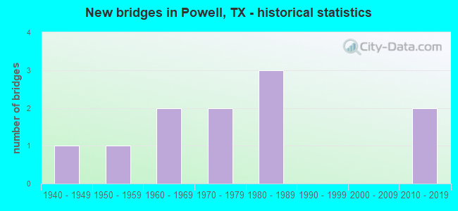
- New bridges - historical statistics
- 11940-1949
- 11950-1959
- 21960-1969
- 21970-1979
- 31980-1989
- 22010-2019


- Bridge Condition - Deck
- 11.1%Very good
- 44.4%Good
- 44.4%Satisfactory

- Bridge Condition - Superstructure
- 33.3%Good
- 66.7%Satisfactory

- Bridge Condition - Substructure
- 11.1%Good
- 77.8%Satisfactory
- 11.1%Fair

- Bridge Condition - Channel
- 27.3%Good
- 72.7%Satisfactory

- Bridge Condition - Culverts
- 50.0%Good
- 50.0%Satisfactory
Find on map >> Show street view
Structure Number: 181750016301031, Location: 4.60 MI E OF IH45 (Lat: 32.109794, Lng: -96.366006), Route carried "on" structure: State highway 31, Year Built: 1964, Status: Open, Structure Length: 18.29m (60.01ft), Average Daily Traffic: 4,784 (year 2019), Truck Traffic: 11%, Average Future Daily Traffic: 10,120 (year 2033), Design Load: H 20, Features Intersected: CHAMBERS CRK REL
Minimum Vertical Clearance: 30+ m (98+ ft), Kilometerpoint: 9.102, Lanes on structure: 2, Owner: State Highway Agency, Approaching Roadway Width: 11.0m (36.1ft), Material/Design: Concrete, Design/Construction: Stringer/Multi-beam, Number Of Spans In Main Unit: 15, Length of Maximum Span: 12.2m (40.0ft), Curb-To-Curb Width: 8.5m (27.9ft), Out-to-Out Width: 9.5m (31.2ft)
Condition: Deck: Satisfactory, Superstructure: Good, Substructure: Good, Channel: Satisfactory, Operating Rating: 53.5 metric tons, Method Used To Determine Operating Rating: Load Factor (LF), Inventory Rating: 31.7 metric tons, Method Used To Determine Inventory Rating: Load Factor (LF), Structural Evaluation: Better than present minimum criteria, Deck Geometry: High priority of corrective action, Waterway Adequacy: Equal to present minimum criteria, Approach Roadway Alignment: Equal to present desirable criteria, Length Of Structure Improvement: 18.29m (60.01ft), Designated Inspection Frequency: Every 24 months, Inspection Date: January 2020, Bridge Improvement Cost: $34,000, Roadway Improvement Cost: $9,000, Total Project Cost: $43,000, Deck Structure Type: Concrete Cast-file-Place
Find on map >> Show street view
Structure Number: 181750016301032, Location: 4.90 MI E OF IH45 (Lat: 32.111244, Lng: -96.360781), Route carried "on" structure: State highway 31, Year Built: 1964, Status: Open, Structure Length: 25.60m (83.99ft), Average Daily Traffic: 4,784 (year 2019), Truck Traffic: 11%, Average Future Daily Traffic: 10,120 (year 2033), Design Load: H 20, Features Intersected: CHAMBERS CRK REL
Minimum Vertical Clearance: 30+ m (98+ ft), Kilometerpoint: 9.621, Lanes on structure: 2, Owner: State Highway Agency, Approaching Roadway Width: 11.0m (36.1ft), Material/Design: Concrete, Design/Construction: Stringer/Multi-beam, Number Of Spans In Main Unit: 21, Length of Maximum Span: 12.2m (40.0ft), Curb-To-Curb Width: 8.5m (27.9ft), Out-to-Out Width: 9.5m (31.2ft)
Condition: Deck: Satisfactory, Superstructure: Good, Substructure: Fair, Channel: Satisfactory, Operating Rating: 49.9 metric tons, Method Used To Determine Operating Rating: Load Factor (LF), Inventory Rating: 29.9 metric tons, Method Used To Determine Inventory Rating: Load Factor (LF), Structural Evaluation: Somewhat better than minimum adequacy, Deck Geometry: High priority of corrective action, Waterway Adequacy: Equal to present minimum criteria, Approach Roadway Alignment: Equal to present desirable criteria, Length Of Structure Improvement: 25.60m (83.99ft), Designated Inspection Frequency: Every 24 months, Inspection Date: January 2020, Bridge Improvement Cost: $47,000, Roadway Improvement Cost: $12,000, Total Project Cost: $59,000, Deck Structure Type: Concrete Cast-file-Place
Find on map >> Show street view
Structure Number: 181750016301049, Location: 4.60 MI E OF IH45 (Lat: 32.109961, Lng: -96.366067), Route carried "on" structure: State highway 31, Year Built: 1984, Status: Open, Structure Length: 18.29m (60.01ft), Average Daily Traffic: 7,826 (year 2020), Truck Traffic: 11%, Average Future Daily Traffic: 10,120 (year 2033), Design Load: HS 20, Features Intersected: CHAMBERS CRK REL
Minimum Vertical Clearance: 30+ m (98+ ft), Kilometerpoint: 9.102, Lanes on structure: 2, Owner: State Highway Agency, Approaching Roadway Width: 11.6m (38.1ft), Material/Design: Concrete, Design/Construction: Stringer/Multi-beam, Number Of Spans In Main Unit: 15, Length of Maximum Span: 12.2m (40.0ft), Curb-To-Curb Width: 11.6m (38.1ft), Out-to-Out Width: 12.3m (40.4ft)
Condition: Deck: Satisfactory, Superstructure: Satisfactory, Substructure: Satisfactory, Channel: Good, Operating Rating: 68.0 metric tons, Method Used To Determine Operating Rating: Load Factor (LF), Inventory Rating: 40.8 metric tons, Method Used To Determine Inventory Rating: Load Factor (LF), Structural Evaluation: Equal to present minimum criteria, Deck Geometry: Better than present minimum criteria, Waterway Adequacy: Equal to present minimum criteria, Approach Roadway Alignment: Equal to present desirable criteria, Designated Inspection Frequency: Every 24 months, Inspection Date: January 2020, Deck Structure Type: Concrete Cast-file-Place
Find on map >> Show street view
Structure Number: 18175001630105, Location: 4.90 MI E OF IH45 (Lat: 32.111428, Lng: -96.360842), Route carried "on" structure: State highway 31, Year Built: 1984, Status: Open, Structure Length: 25.60m (83.99ft), Average Daily Traffic: 7,826 (year 2020), Truck Traffic: 11%, Average Future Daily Traffic: 10,120 (year 2033), Design Load: HS 20, Features Intersected: CHAMBERS CRK REL
Minimum Vertical Clearance: 30+ m (98+ ft), Kilometerpoint: 9.621, Lanes on structure: 2, Owner: State Highway Agency, Approaching Roadway Width: 11.6m (38.1ft), Material/Design: Concrete, Design/Construction: Stringer/Multi-beam, Number Of Spans In Main Unit: 21, Length of Maximum Span: 12.2m (40.0ft), Curb-To-Curb Width: 11.6m (38.1ft), Out-to-Out Width: 12.3m (40.4ft)
Condition: Deck: Good, Superstructure: Good, Substructure: Satisfactory, Channel: Good, Operating Rating: 68.0 metric tons, Method Used To Determine Operating Rating: Load Factor (LF), Inventory Rating: 40.8 metric tons, Method Used To Determine Inventory Rating: Load Factor (LF), Structural Evaluation: Equal to present minimum criteria, Deck Geometry: Better than present minimum criteria, Waterway Adequacy: Equal to present minimum criteria, Approach Roadway Alignment: Equal to present desirable criteria, Designated Inspection Frequency: Every 24 months, Inspection Date: January 2020, Deck Structure Type: Concrete Cast-file-Place
Find on map >> Show street view
Structure Number: 181750016302041, Location: 9.6 MI E OF IH45 (Lat: 32.124475, Lng: -96.279789), Route carried "on" structure: State highway 31, Year Built: 1972, Status: Open, Structure Length: 5.33m (17.49ft), Average Daily Traffic: 4,260 (year 2013), Truck Traffic: 14%, Average Future Daily Traffic: 5,970 (year 2033), Design Load: HS 20, Features Intersected: LITTLE RUSH CRK
Minimum Vertical Clearance: 30+ m (98+ ft), Kilometerpoint: 17.482, Lanes on structure: 2, Owner: State Highway Agency, Approaching Roadway Width: 11.6m (38.1ft), Skew: 4 degrees, Material/Design: Concrete, Design/Construction: Stringer/Multi-beam, Number Of Spans In Main Unit: 4, Length of Maximum Span: 13.1m (43.0ft), Curb-To-Curb Width: 12.8m (42.0ft), Out-to-Out Width: 13.5m (44.3ft)
Condition: Deck: Satisfactory, Superstructure: Satisfactory, Substructure: Satisfactory, Channel: Satisfactory, Operating Rating: 54.4 metric tons, Method Used To Determine Operating Rating: Load Factor (LF), Inventory Rating: 32.7 metric tons, Method Used To Determine Inventory Rating: Load Factor (LF), Structural Evaluation: Equal to present minimum criteria, Deck Geometry: Equal to present desirable criteria, Waterway Adequacy: Equal to present minimum criteria, Approach Roadway Alignment: Equal to present desirable criteria, Designated Inspection Frequency: Every 24 months, Inspection Date: March 2020, Deck Structure Type: Concrete Cast-file-Place
Find on map >> Show street view
Structure Number: 181750016302042, Location: 9.6 MI E OF IH45 (Lat: 32.124300, Lng: -96.279742), Route carried "on" structure: State highway 31, Year Built: 1972, Status: Open, Structure Length: 5.33m (17.49ft), Average Daily Traffic: 4,260 (year 2013), Truck Traffic: 14%, Average Future Daily Traffic: 5,970 (year 2033), Design Load: HS 20, Features Intersected: LITTLE RUSH CRK
Minimum Vertical Clearance: 30+ m (98+ ft), Kilometerpoint: 17.503, Lanes on structure: 2, Owner: State Highway Agency, Approaching Roadway Width: 11.6m (38.1ft), Skew: 4 degrees, Material/Design: Concrete, Design/Construction: Stringer/Multi-beam, Number Of Spans In Main Unit: 4, Length of Maximum Span: 13.1m (43.0ft), Curb-To-Curb Width: 12.8m (42.0ft), Out-to-Out Width: 13.5m (44.3ft)
Condition: Deck: Good, Superstructure: Satisfactory, Substructure: Satisfactory, Channel: Satisfactory, Operating Rating: 54.4 metric tons, Method Used To Determine Operating Rating: Load Factor (LF), Inventory Rating: 32.7 metric tons, Method Used To Determine Inventory Rating: Load Factor (LF), Structural Evaluation: Equal to present minimum criteria, Deck Geometry: Equal to present desirable criteria, Waterway Adequacy: Equal to present minimum criteria, Approach Roadway Alignment: Equal to present desirable criteria, Designated Inspection Frequency: Every 24 months, Inspection Date: March 2020, Deck Structure Type: Concrete Cast-file-Place
Find on map >> Show street view
Structure Number: 181750071901001, Location: 1.20 MI S OF SH 31 (Lat: 32.102331, Lng: -96.317239), Route carried "on" structure: State highway 633, Year Built: 1947, Year Reconstructed: 2005, Status: Open, Structure Length: 1.01m (3.31ft), Average Daily Traffic: 298 (year 2020), Truck Traffic: 6%, Average Future Daily Traffic: 410 (year 2033), Design Load: H 15, Features Intersected: DE ARMAN BR
Minimum Vertical Clearance: 30+ m (98+ ft), Kilometerpoint: 1.981, Lanes on structure: 2, Owner: State Highway Agency, Approaching Roadway Width: 7.9m (25.9ft), Skew: 4 degrees, Material/Design: Concrete, Design/Construction: Culvert, Number Of Spans In Main Unit: 3, Length of Maximum Span: 3.0m (9.8ft), Curb-To-Curb Width: 10.5m (34.4ft), Out-to-Out Width: 11.4m (37.4ft)
Condition: Channel: Satisfactory, Culverts: Satisfactory, Operating Rating: 39.9 metric tons, Method Used To Determine Operating Rating: Load Factor (LF), Inventory Rating: 23.6 metric tons, Method Used To Determine Inventory Rating: Load Factor (LF), Structural Evaluation: Equal to present minimum criteria, Deck Geometry: Better than present minimum criteria, Waterway Adequacy: Better than present minimum criteria, Approach Roadway Alignment: Equal to present desirable criteria, Length Of Structure Improvement: 1.01m (3.31ft), Designated Inspection Frequency: Every 24 months, Inspection Date: January 2020, Bridge Improvement Cost: $1,000, Total Project Cost: $1,000, Deck Structure Type: Concrete Cast-file-Place, Wearing Surface/Protective System: Wearing Surface: Bituminous
Find on map >> Show street view
Structure Number: 181750071902002, Location: 1.00 MI S OF FM 3041 (Lat: 32.159456, Lng: -96.374794), Route carried "on" structure: State highway 1129, Year Built: 1950, Status: Open, Structure Length: 0.82m (2.69ft), Average Daily Traffic: 710 (year 2020), Truck Traffic: 4%, Average Future Daily Traffic: 600 (year 2033), Design Load: H 15, Features Intersected: BRANCH LITTLE RUSH CREEK
Minimum Vertical Clearance: 30+ m (98+ ft), Kilometerpoint: 21.177, Lanes on structure: 2, Owner: State Highway Agency, Approaching Roadway Width: 7.3m (24.0ft), Material/Design: Concrete, Design/Construction: Culvert, Number Of Spans In Main Unit: 4, Length of Maximum Span: 1.8m (5.9ft), Curb-To-Curb Width: 7.6m (24.9ft), Out-to-Out Width: 10.8m (35.4ft)
Condition: Channel: Satisfactory, Culverts: Good, Operating Rating: 39.9 metric tons, Method Used To Determine Operating Rating: Load Factor (LF), Inventory Rating: 23.6 metric tons, Method Used To Determine Inventory Rating: Load Factor (LF), Structural Evaluation: Equal to present minimum criteria, Deck Geometry: Meets minimum limits, Waterway Adequacy: Equal to present minimum criteria, Approach Roadway Alignment: Equal to present desirable criteria, Designated Inspection Frequency: Every 24 months, Inspection Date: January 2020, Deck Structure Type: Concrete Cast-file-Place, Wearing Surface/Protective System: Wearing Surface: Bituminous
Find on map >> Show street view
Structure Number: 181750AA0340002, Location: 1.4 MI SE OF CR NE 2030 (Lat: 32.137022, Lng: -96.341089), Route carried "on" structure: County highway 2010, Year Built: 1985, Status: Posted for load, Structure Length: 1.25m (4.10ft), Average Daily Traffic: 100 (year 2019), Average Future Daily Traffic: 50 (year 2031), Features Intersected: LITTLE RUSH CREEK
Minimum Vertical Clearance: 30+ m (98+ ft), Kilometerpoint: 2.253, Lanes on structure: 1, Owner: County Highway Agency, Approaching Roadway Width: 4.9m (16.1ft), Material/Design: Steel, Design/Construction: Stringer/Multi-beam, Number Of Spans In Main Unit: 1, Length of Maximum Span: 11.9m (39.0ft), Curb-To-Curb Width: 4.3m (14.1ft), Out-to-Out Width: 4.9m (16.1ft)
Condition: Deck: Good, Superstructure: Satisfactory, Substructure: Satisfactory, Channel: Satisfactory, Operating Rating: 29.9 metric tons, Method Used To Determine Operating Rating: Allowable Stress (AS), Inventory Rating: 20.9 metric tons, Method Used To Determine Inventory Rating: Allowable Stress (AS), Structural Evaluation: Equal to present minimum criteria, Deck Geometry: Equal to present minimum criteria, Waterway Adequacy: Meets minimum limits, Approach Roadway Alignment: Equal to present desirable criteria, Bridge Posting: Required (Relationship of Operating Rating to Maximum Legal Load: 0.1 - 9.9% below), Length Of Structure Improvement: 1.25m (4.10ft), Designated Inspection Frequency: Every 24 months, Inspection Date: November 2020, Total Project Cost: $11,000, Deck Structure Type: Wood or Timber, Wearing Surface/Protective System: Wearing Surface: Wood or Timber
Find on map >> Show street view
Structure Number: 181750AA0340003, Location: .4 MI EAST O POWELL CITY (Lat: 32.125603, Lng: -96.318186), Route carried "on" structure: County highway 2110, Year Built: 2014, Status: Posted for load, Structure Length: 1.16m (3.81ft), Average Daily Traffic: 100 (year 2014), Average Future Daily Traffic: 50 (year 2031), Features Intersected: LITTLE RUSH CREEK
Minimum Vertical Clearance: 30+ m (98+ ft), Kilometerpoint: 5.633, Lanes on structure: 1, Owner: County Highway Agency, Approaching Roadway Width: 4.3m (14.1ft), Material/Design: Steel, Design/Construction: Stringer/Multi-beam, Number Of Spans In Main Unit: 1, Length of Maximum Span: 11.6m (38.1ft), Curb-To-Curb Width: 4.3m (14.1ft), Out-to-Out Width: 4.9m (16.1ft)
Condition: Deck: Very good, Superstructure: Satisfactory, Substructure: Satisfactory, Channel: Good, Operating Rating: 30.8 metric tons, Method Used To Determine Operating Rating: Allowable Stress (AS), Inventory Rating: 21.8 metric tons, Method Used To Determine Inventory Rating: Allowable Stress (AS), Structural Evaluation: Equal to present minimum criteria, Deck Geometry: Equal to present minimum criteria, Waterway Adequacy: Meets minimum limits, Approach Roadway Alignment: Equal to present desirable criteria, Bridge Posting: Required (Relationship of Operating Rating to Maximum Legal Load: 10.0 - 19.9% below), Designated Inspection Frequency: Every 24 months, Inspection Date: November 2020, Deck Structure Type: Wood or Timber, Wearing Surface/Protective System: Wearing Surface: Wood or Timber
Find on map >> Show street view
Structure Number: 181750AA0341001, Location: 0.45 MI N OF SH 31 (Lat: 32.127617, Lng: -96.299325), Route carried "on" structure: County highway 2120, Year Built: 2013, Status: Open, Structure Length: 1.86m (6.10ft), Average Daily Traffic: 258 (year 2019), Average Future Daily Traffic: 100 (year 2031), Features Intersected: LITTLE RUSH CREEK
Minimum Vertical Clearance: 30+ m (98+ ft), Kilometerpoint: 0.644, Lanes on structure: 2, Owner: County Highway Agency, Approaching Roadway Width: 5.5m (18.0ft), Material/Design: Steel, Design/Construction: Stringer/Multi-beam, Number Of Spans In Main Unit: 1, Number Of Approach Spans: 2, Length of Maximum Span: 10.7m (35.1ft), Curb-To-Curb Width: 7.2m (23.6ft), Out-to-Out Width: 7.3m (24.0ft)
Condition: Deck: Good, Superstructure: Satisfactory, Substructure: Satisfactory, Channel: Satisfactory, Operating Rating: 32.7 metric tons, Method Used To Determine Operating Rating: Field evaluation and documented engineering judgment, Inventory Rating: 24.5 metric tons, Method Used To Determine Inventory Rating: Field evaluation and documented engineering judgment, Structural Evaluation: Equal to present minimum criteria, Deck Geometry: Meets minimum limits, Waterway Adequacy: Better than present minimum criteria, Approach Roadway Alignment: Equal to present desirable criteria, Length Of Structure Improvement: 1.25m (4.10ft), Designated Inspection Frequency: Every 24 months, Inspection Date: November 2020, Bridge Improvement Cost: $1,000, Total Project Cost: $1,000, Deck Structure Type: Corrugated Steel