Bridge Statistics for Poynor, Texas (TX)
Condition, Traffic, Stress, Structural Evaluation, Project Costs
- National Bridge Inventory (NBI) Statistics
- 20Number of bridges
- 187ft / 57.1mTotal length
- 73,155Total average daily traffic
- 12,524Total average daily truck traffic
- National Bridge Inventory (NBI) Registered Bridges for Poynor
- No street view available for this location
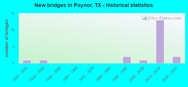
- New bridges - historical statistics
- 11930-1939
- 11940-1949
- 21990-1999
- 12000-2009
- 132010-2019
- 22020-2022


- Bridge Condition - Deck
- 14.3%Very good
- 85.7%Good

- Bridge Condition - Superstructure
- 57.1%Very good
- 42.9%Good

- Bridge Condition - Substructure
- 28.6%Very good
- 42.9%Good
- 28.6%Satisfactory

- Bridge Condition - Channel
- 12.5%Very good
- 56.3%Good
- 18.8%Satisfactory
- 12.5%Fair

- Bridge Condition - Culverts
- 9.1%Very good
- 63.6%Good
- 27.3%Satisfactory
Find on map >> Show street view
Structure Number: 100010019803032, Location: 2.4mi E of FM 315 (Lat: 32.063222, Lng: -95.560536), Route carried "on" structure: US 175, Year Built: 2020, Status: Open, Structure Length: 0.76m (2.49ft), Average Daily Traffic: 3,791 (year 2020), Truck Traffic: 10%, Average Future Daily Traffic: 6,700 (year 2025), Design Load: HL 93, Features Intersected: Caddo Cr Tr
Minimum Vertical Clearance: 30+ m (98+ ft), Kilometerpoint: 0.848, Lanes on structure: 6, Owner: State Highway Agency, Approaching Roadway Width: 30.5m (100.1ft), Skew: 10 degrees, Material/Design: Concrete, Design/Construction: Culvert, Number Of Spans In Main Unit: 2, Length of Maximum Span: 3.0m (9.8ft)
Condition: Channel: Good, Culverts: Good, Operating Rating: 54.4 metric tons, Method Used To Determine Operating Rating: Assigned ratings based on Load and Resistance Factor Design (LRFD) reported in metric tons, Inventory Rating: 32.7 metric tons, Method Used To Determine Inventory Rating: Assigned ratings based on Load and Resistance Factor Design (LRFD) reported in metric tons, Structural Evaluation: Better than present minimum criteria, Waterway Adequacy: Superior to present desirable criteria, Approach Roadway Alignment: Equal to present desirable criteria, Designated Inspection Frequency: Every 24 months, Inspection Date: December 2020
Find on map >> Show street view
Structure Number: 100010019803033, Location: 2.1mi E of FM 315 (Lat: 32.064131, Lng: -95.564022), Route carried "on" structure: US 175, Year Built: 2020, Status: Open, Structure Length: 1.16m (3.81ft), Average Daily Traffic: 3,791 (year 2020), Truck Traffic: 10%, Average Future Daily Traffic: 6,700 (year 2025), Design Load: HL 93, Features Intersected: Caddo Cr Tr
Minimum Vertical Clearance: 30+ m (98+ ft), Kilometerpoint: 0.504, Lanes on structure: 4, Owner: State Highway Agency, Approaching Roadway Width: 25.0m (82.0ft), Skew: 11 degrees, Material/Design: Concrete, Design/Construction: Culvert, Number Of Spans In Main Unit: 3, Length of Maximum Span: 3.0m (9.8ft)
Condition: Channel: Very good, Culverts: Good, Operating Rating: 54.4 metric tons, Method Used To Determine Operating Rating: Assigned ratings based on Load and Resistance Factor Design (LRFD) reported in metric tons, Inventory Rating: 32.7 metric tons, Method Used To Determine Inventory Rating: Assigned ratings based on Load and Resistance Factor Design (LRFD) reported in metric tons, Structural Evaluation: Better than present minimum criteria, Waterway Adequacy: Superior to present desirable criteria, Approach Roadway Alignment: Equal to present desirable criteria, Designated Inspection Frequency: Every 24 months, Inspection Date: December 2020
Find on map >> Show street view
Structure Number: 100010AA0483101, Location: 0.20 MI W OF CR 482 (Lat: 32.031561, Lng: -95.641506), Route carried "on" structure: County highway 483, Year Built: 2003, Status: Open, Structure Length: 1.25m (4.10ft), Average Daily Traffic: 50 (year 2013), Average Future Daily Traffic: 60 (year 2035), Features Intersected: INDIAN CREEK
Minimum Vertical Clearance: 30+ m (98+ ft), Kilometerpoint: 0.161, Lanes on structure: 1, Owner: County Highway Agency, Approaching Roadway Width: 3.7m (12.1ft), Material/Design: Steel, Design/Construction: Stringer/Multi-beam, Number Of Spans In Main Unit: 1, Length of Maximum Span: 11.9m (39.0ft), Curb-To-Curb Width: 4.8m (15.7ft), Out-to-Out Width: 5.0m (16.4ft)
Condition: Deck: Good, Superstructure: Good, Substructure: Satisfactory, Channel: Fair, Operating Rating: 68.0 metric tons, Method Used To Determine Operating Rating: Allowable Stress (AS), Inventory Rating: 40.8 metric tons, Method Used To Determine Inventory Rating: Allowable Stress (AS), Structural Evaluation: Equal to present minimum criteria, Deck Geometry: Equal to present desirable criteria, Waterway Adequacy: Meets minimum limits, Approach Roadway Alignment: Equal to present desirable criteria, Designated Inspection Frequency: Every 24 months, Inspection Date: September 2021, Deck Structure Type: Concrete Cast-file-Place
Find on map >> Show street view
Structure Number: 101080019802008, Location: 0.2 MI NW OF FM 315 (Lat: 32.076242, Lng: -95.601244), Route carried "on" structure: State highway 175, Year Built: 1930, Status: Open, Structure Length: 1.34m (4.40ft), Average Daily Traffic: 4,328 (year 2020), Truck Traffic: 23%, Average Future Daily Traffic: 6,200 (year 2033), Design Load: H 15, Features Intersected: MILL BR CADDO CRK
Minimum Vertical Clearance: 30+ m (98+ ft), Kilometerpoint: 56.161, Lanes on structure: 2, Owner: State Highway Agency, Approaching Roadway Width: 7.3m (24.0ft), Material/Design: Concrete, Design/Construction: Culvert, Number Of Spans In Main Unit: 4, Length of Maximum Span: 3.0m (9.8ft)
Condition: Channel: Satisfactory, Culverts: Good, Operating Rating: 39.9 metric tons, Method Used To Determine Operating Rating: Load Factor (LF), Inventory Rating: 23.6 metric tons, Method Used To Determine Inventory Rating: Load Factor (LF), Structural Evaluation: Equal to present minimum criteria, Waterway Adequacy: Equal to present minimum criteria, Approach Roadway Alignment: Equal to present desirable criteria, Designated Inspection Frequency: Every 24 months, Inspection Date: Febuary 2021
Find on map >> Show street view
Structure Number: 101080019802029, Location: 0.2mi W of FM 315 (Lat: 32.075244, Lng: -95.602744), Route carried "on" structure: US 175, Year Built: 2017, Status: Open, Structure Length: 1.59m (5.22ft), Average Daily Traffic: 4,328 (year 2020), Truck Traffic: 23%, Average Future Daily Traffic: 6,540 (year 2033), Design Load: HL 93, Features Intersected: Mill Creek
Minimum Vertical Clearance: 30+ m (98+ ft), Kilometerpoint: 0.000, Lanes on structure: 4, Base Highway Network: Yes, Owner: State Highway Agency, Approaching Roadway Width: 23.2m (76.1ft), Material/Design: Concrete, Design/Construction: Culvert, Number Of Spans In Main Unit: 5, Length of Maximum Span: 3.0m (9.8ft)
Condition: Channel: Good, Culverts: Good, Operating Rating: 44.4 metric tons, Method Used To Determine Operating Rating: Assigned ratings based on Load and Resistance Factor Design (LRFD) reported in metric tons, Inventory Rating: 32.7 metric tons, Method Used To Determine Inventory Rating: Assigned ratings based on Load and Resistance Factor Design (LRFD) reported in metric tons, Structural Evaluation: Better than present minimum criteria, Waterway Adequacy: Superior to present desirable criteria, Approach Roadway Alignment: Equal to present desirable criteria, Designated Inspection Frequency: Every 48 months, Inspection Date: March 2019
Find on map >> Show street view
Structure Number: 101080019802035, Location: 0.4mi E of FM 315 (Lat: 32.070428, Lng: -95.593725), Route carried "on" structure: US 175, Year Built: 2017, Status: Open, Structure Length: 0.67m (2.20ft), Average Daily Traffic: 4,670 (year 2013), Truck Traffic: 23%, Average Future Daily Traffic: 6,540 (year 2033), Design Load: HL 93, Features Intersected: Caddo Creek Trib
Minimum Vertical Clearance: 30+ m (98+ ft), Kilometerpoint: 0.000, Lanes on structure: 4, Base Highway Network: Yes, Owner: State Highway Agency, Approaching Roadway Width: 26.8m (87.9ft), Skew: 1 degrees, Material/Design: Concrete, Design/Construction: Culvert, Number Of Spans In Main Unit: 4, Length of Maximum Span: 1.5m (4.9ft)
Condition: Channel: Good, Culverts: Very good, Operating Rating: 44.4 metric tons, Method Used To Determine Operating Rating: Assigned ratings based on Load and Resistance Factor Design (LRFD) reported in metric tons, Inventory Rating: 32.7 metric tons, Method Used To Determine Inventory Rating: Assigned ratings based on Load and Resistance Factor Design (LRFD) reported in metric tons, Structural Evaluation: Equal to present desirable criteria, Waterway Adequacy: Superior to present desirable criteria, Approach Roadway Alignment: Equal to present desirable criteria, Designated Inspection Frequency: Every 48 months, Inspection Date: March 2019
Find on map >> Show street view
Structure Number: 101080019802036, Location: 0.5mi W of FM 315 (Lat: 32.077903, Lng: -95.605928), Route carried "on" structure: US 175, Year Built: 2017, Status: Open, Structure Length: 0.98m (3.22ft), Average Daily Traffic: 4,328 (year 2020), Truck Traffic: 23%, Average Future Daily Traffic: 1 (year 1900), Design Load: HL 93, Features Intersected: Caddo Creek Trib
Minimum Vertical Clearance: 30+ m (98+ ft), Kilometerpoint: 0.000, Lanes on structure: 4, Base Highway Network: Yes, Owner: State Highway Agency, Approaching Roadway Width: 23.2m (76.1ft), Material/Design: Concrete, Design/Construction: Culvert, Number Of Spans In Main Unit: 3, Length of Maximum Span: 3.0m (9.8ft)
Condition: Channel: Satisfactory, Culverts: Satisfactory, Operating Rating: 44.4 metric tons, Method Used To Determine Operating Rating: Assigned ratings based on Load and Resistance Factor Design (LRFD) reported in metric tons, Inventory Rating: 32.7 metric tons, Method Used To Determine Inventory Rating: Assigned ratings based on Load and Resistance Factor Design (LRFD) reported in metric tons, Structural Evaluation: Equal to present minimum criteria, Waterway Adequacy: Superior to present desirable criteria, Approach Roadway Alignment: Equal to present desirable criteria, Designated Inspection Frequency: Every 48 months, Inspection Date: March 2019
Find on map >> Show street view
Structure Number: 101080019802037, Location: 0.9mi W of FM 315 (Lat: 32.080886, Lng: -95.610894), Route carried "on" structure: US 175, Year Built: 2017, Status: Open, Structure Length: 1.13m (3.71ft), Average Daily Traffic: 4,328 (year 2020), Truck Traffic: 23%, Average Future Daily Traffic: 1 (year 1900), Design Load: HL 93, Features Intersected: Caddo Creek Trib
Minimum Vertical Clearance: 30+ m (98+ ft), Kilometerpoint: 0.000, Lanes on structure: 4, Base Highway Network: Yes, Owner: State Highway Agency, Approaching Roadway Width: 18.9m (62.0ft), Skew: 3 degrees, Material/Design: Concrete, Design/Construction: Culvert, Number Of Spans In Main Unit: 3, Length of Maximum Span: 3.0m (9.8ft)
Condition: Channel: Good, Culverts: Good, Operating Rating: 44.4 metric tons, Method Used To Determine Operating Rating: Assigned ratings based on Load and Resistance Factor Design (LRFD) reported in metric tons, Inventory Rating: 32.7 metric tons, Method Used To Determine Inventory Rating: Assigned ratings based on Load and Resistance Factor Design (LRFD) reported in metric tons, Structural Evaluation: Better than present minimum criteria, Waterway Adequacy: Superior to present desirable criteria, Approach Roadway Alignment: Equal to present desirable criteria, Designated Inspection Frequency: Every 48 months, Inspection Date: March 2019
Find on map >> Show street view
Structure Number: 101080019802038, Location: 2.3mi E of RM 2588 (Lat: 32.096617, Lng: -95.642353), Route carried "on" structure: US 175, Year Built: 2017, Status: Open, Structure Length: 1.04m (3.41ft), Average Daily Traffic: 4,189 (year 2020), Truck Traffic: 23%, Average Future Daily Traffic: 6,540 (year 2033), Design Load: HL 93, Features Intersected: Caddo Creek Trib
Minimum Vertical Clearance: 30+ m (98+ ft), Kilometerpoint: 0.000, Lanes on structure: 4, Base Highway Network: Yes, Owner: State Highway Agency, Approaching Roadway Width: 29.9m (98.1ft), Skew: 4 degrees, Material/Design: Concrete, Design/Construction: Culvert, Number Of Spans In Main Unit: 3, Length of Maximum Span: 2.4m (7.9ft)
Condition: Channel: Good, Culverts: Good, Operating Rating: 44.4 metric tons, Method Used To Determine Operating Rating: Assigned ratings based on Load and Resistance Factor Design (LRFD) reported in metric tons, Inventory Rating: 32.7 metric tons, Method Used To Determine Inventory Rating: Assigned ratings based on Load and Resistance Factor Design (LRFD) reported in metric tons, Structural Evaluation: Better than present minimum criteria, Waterway Adequacy: Superior to present desirable criteria, Approach Roadway Alignment: Equal to present desirable criteria, Designated Inspection Frequency: Every 48 months, Inspection Date: March 2019
Find on map >> Show street view
Structure Number: 101080019802039, Location: 2.4 MI W of FM 315 (Lat: 32.091386, Lng: -95.630100), Route carried "on" structure: US 175, Year Built: 2017, Status: Open, Structure Length: 6.71m (22.01ft), Average Daily Traffic: 4,189 (year 2020), Average Future Daily Traffic: 1 (year 1900), Design Load: HL 93, Features Intersected: Caddo Cr Tr (Lake)
Minimum Vertical Clearance: 30+ m (98+ ft), Kilometerpoint: 3.862, Lanes on structure: 2, Base Highway Network: Yes, Owner: State Highway Agency, Approaching Roadway Width: 11.6m (38.1ft), Material/Design: Prestressed concrete, Design/Construction: Stringer/Multi-beam, Number Of Spans In Main Unit: 2, Length of Maximum Span: 33.5m (109.9ft), Curb-To-Curb Width: 11.6m (38.1ft), Out-to-Out Width: 12.2m (40.0ft)
Condition: Deck: Good, Superstructure: Very good, Substructure: Satisfactory, Channel: Very good, Operating Rating: 54.4 metric tons, Method Used To Determine Operating Rating: Assigned ratings based on Load and Resistance Factor Design (LRFD) reported in metric tons, Inventory Rating: 32.7 metric tons, Method Used To Determine Inventory Rating: Assigned ratings based on Load and Resistance Factor Design (LRFD) reported in metric tons, Structural Evaluation: Equal to present minimum criteria, Deck Geometry: Better than present minimum criteria, Waterway Adequacy: Equal to present desirable criteria, Approach Roadway Alignment: Equal to present desirable criteria, Designated Inspection Frequency: Every 24 months, Inspection Date: Febuary 2021, Deck Structure Type: Concrete Precast Panels
Find on map >> Show street view
Structure Number: 10108001980204, Location: 2.9 MI E of RM 2588 (Lat: 32.092553, Lng: -95.632828), Route carried "on" structure: US 175, Year Built: 2017, Status: Open, Structure Length: 16.76m (54.99ft), Average Daily Traffic: 4,189 (year 2020), Average Future Daily Traffic: 1 (year 1900), Design Load: HL 93, Features Intersected: Caddo Cr Tr
Minimum Vertical Clearance: 30+ m (98+ ft), Kilometerpoint: 4.667, Lanes on structure: 2, Base Highway Network: Yes, Owner: State Highway Agency, Approaching Roadway Width: 11.6m (38.1ft), Material/Design: Prestressed concrete, Design/Construction: Stringer/Multi-beam, Number Of Spans In Main Unit: 5, Length of Maximum Span: 33.5m (109.9ft), Curb-To-Curb Width: 11.6m (38.1ft), Out-to-Out Width: 12.2m (40.0ft)
Condition: Deck: Good, Superstructure: Very good, Substructure: Good, Channel: Good, Operating Rating: 54.4 metric tons, Method Used To Determine Operating Rating: Assigned ratings based on Load and Resistance Factor Design (LRFD) reported in metric tons, Inventory Rating: 32.7 metric tons, Method Used To Determine Inventory Rating: Assigned ratings based on Load and Resistance Factor Design (LRFD) reported in metric tons, Structural Evaluation: Better than present minimum criteria, Deck Geometry: Better than present minimum criteria, Waterway Adequacy: Equal to present desirable criteria, Approach Roadway Alignment: Equal to present desirable criteria, Designated Inspection Frequency: Every 24 months, Inspection Date: Febuary 2021, Deck Structure Type: Concrete Precast Panels
Find on map >> Show street view
Structure Number: 101080019802041, Location: 0.1mi S of BU 175 H (Lat: 32.073506, Lng: -95.599678), Route carried "on" structure: US 175, Year Built: 2017, Status: Open, Structure Length: 4.88m (16.01ft), Average Daily Traffic: 5,346 (year 2018), Truck Traffic: 23%, Average Future Daily Traffic: 6,700 (year 2025), Design Load: HL 93, Features Intersected: FM 315
Minimum Vertical Clearance: 30+ m (98+ ft), Kilometerpoint: 0.000, Lanes on structure: 2, Lanes under structure: 2, Owner: State Highway Agency, Approaching Roadway Width: 11.6m (38.1ft), Skew: 1 degrees, Material/Design: Prestressed concrete, Design/Construction: Stringer/Multi-beam, Number Of Spans In Main Unit: 1, Number Of Approach Spans: 2, Length of Maximum Span: 24.4m (80.1ft), Curb-To-Curb Width: 11.6m (38.1ft), Out-to-Out Width: 12.2m (40.0ft)
Condition: Deck: Very good, Superstructure: Very good, Substructure: Very good, Operating Rating: 54.4 metric tons, Method Used To Determine Operating Rating: Assigned ratings based on Load and Resistance Factor Design (LRFD) reported in metric tons, Inventory Rating: 32.7 metric tons, Method Used To Determine Inventory Rating: Assigned ratings based on Load and Resistance Factor Design (LRFD) reported in metric tons, Structural Evaluation: Equal to present desirable criteria, Deck Geometry: Better than present minimum criteria, Underclear: Somewhat better than minimum adequacy, Approach Roadway Alignment: Equal to present desirable criteria, Designated Inspection Frequency: Every 24 months, Inspection Date: Febuary 2021, Deck Structure Type: Concrete Precast Panels
Find on map >> Show street view
Structure Number: 101080019802042, Location: 0.12 MI S of BU 175H (Lat: 32.073256, Lng: -95.599858), Route carried "on" structure: US 175, Year Built: 2017, Status: Open, Structure Length: 5.18m (16.99ft), Average Daily Traffic: 5,346 (year 2018), Truck Traffic: 23%, Average Future Daily Traffic: 1 (year 1900), Design Load: HL 93, Features Intersected: FM 315
Minimum Vertical Clearance: 30+ m (98+ ft), Kilometerpoint: 0.193, Lanes on structure: 2, Lanes under structure: 2, Owner: State Highway Agency, Approaching Roadway Width: 11.6m (38.1ft), Skew: 1 degrees, Material/Design: Prestressed concrete, Design/Construction: Stringer/Multi-beam, Number Of Spans In Main Unit: 1, Number Of Approach Spans: 2, Length of Maximum Span: 24.4m (80.1ft), Curb-To-Curb Width: 11.6m (38.1ft), Out-to-Out Width: 12.2m (40.0ft)
Condition: Deck: Good, Superstructure: Very good, Substructure: Very good, Operating Rating: 54.4 metric tons, Method Used To Determine Operating Rating: Assigned ratings based on Load and Resistance Factor Design (LRFD) reported in metric tons, Inventory Rating: 32.7 metric tons, Method Used To Determine Inventory Rating: Assigned ratings based on Load and Resistance Factor Design (LRFD) reported in metric tons, Structural Evaluation: Equal to present desirable criteria, Deck Geometry: Better than present minimum criteria, Underclear: Somewhat better than minimum adequacy, Approach Roadway Alignment: Equal to present desirable criteria, Designated Inspection Frequency: Every 24 months, Inspection Date: March 2021, Deck Structure Type: Concrete Precast Panels
Find on map >> Show street view
Structure Number: 101080019802043, Location: 1.6mi W of FM 315 (Lat: 32.086647, Lng: -95.620839), Route carried "on" structure: US 175, Year Built: 2017, Status: Open, Structure Length: 1.68m (5.51ft), Average Daily Traffic: 4,328 (year 2020), Truck Traffic: 23%, Average Future Daily Traffic: 6,540 (year 2033), Design Load: HL 93, Features Intersected: Caddo Creek Trib
Minimum Vertical Clearance: 30+ m (98+ ft), Kilometerpoint: 0.000, Lanes on structure: 4, Base Highway Network: Yes, Owner: State Highway Agency, Approaching Roadway Width: 18.9m (62.0ft), Skew: 1 degrees, Material/Design: Concrete, Design/Construction: Culvert, Number Of Spans In Main Unit: 5, Length of Maximum Span: 3.0m (9.8ft)
Condition: Channel: Satisfactory, Culverts: Satisfactory, Operating Rating: 44.4 metric tons, Method Used To Determine Operating Rating: Assigned ratings based on Load and Resistance Factor Design (LRFD) reported in metric tons, Inventory Rating: 32.7 metric tons, Method Used To Determine Inventory Rating: Assigned ratings based on Load and Resistance Factor Design (LRFD) reported in metric tons, Structural Evaluation: Equal to present minimum criteria, Waterway Adequacy: Superior to present desirable criteria, Approach Roadway Alignment: Equal to present desirable criteria, Designated Inspection Frequency: Every 48 months, Inspection Date: March 2019
Find on map >> Show street view
Structure Number: 101080019802047, Location: 0.9mi E of RM 2588 (Lat: 32.106708, Lng: -95.661797), Route carried "on" structure: US 175, Year Built: 2017, Status: Open, Structure Length: 2.38m (7.81ft), Average Daily Traffic: 4,189 (year 2020), Truck Traffic: 23%, Average Future Daily Traffic: 6,540 (year 2033), Design Load: HS 20, Features Intersected: Pierce Creek
Minimum Vertical Clearance: 30+ m (98+ ft), Kilometerpoint: 0.000, Lanes on structure: 4, Base Highway Network: Yes, Owner: State Highway Agency, Approaching Roadway Width: 23.2m (76.1ft), Skew: 1 degrees, Material/Design: Concrete, Design/Construction: Culvert, Number Of Spans In Main Unit: 7, Length of Maximum Span: 3.0m (9.8ft)
Condition: Channel: Good, Culverts: Good, Operating Rating: 44.4 metric tons, Method Used To Determine Operating Rating: Assigned rating based on Load Factor Design (LFD) reported in metric tons, Inventory Rating: 32.7 metric tons, Method Used To Determine Inventory Rating: Assigned rating based on Load Factor Design (LFD) reported in metric tons, Structural Evaluation: Better than present minimum criteria, Waterway Adequacy: Superior to present desirable criteria, Approach Roadway Alignment: Equal to present desirable criteria, Designated Inspection Frequency: Every 48 months, Inspection Date: March 2019
Find on map >> Show street view
Structure Number: 101080089001003, Location: 2.90 MI S OF FM 314 (Lat: 32.124186, Lng: -95.575353), Route carried "on" structure: State highway 315, Year Built: 1948, Status: Open, Structure Length: 0.79m (2.59ft), Average Daily Traffic: 473 (year 2020), Truck Traffic: 9%, Average Future Daily Traffic: 740 (year 2033), Design Load: H 15, Features Intersected: LEDBETTER CREEK
Minimum Vertical Clearance: 30+ m (98+ ft), Kilometerpoint: 30.294, Lanes on structure: 2, Owner: State Highway Agency, Approaching Roadway Width: 6.1m (20.0ft), Material/Design: Concrete, Design/Construction: Culvert, Number Of Spans In Main Unit: 3, Length of Maximum Span: 2.4m (7.9ft), Curb-To-Curb Width: 9.4m (30.8ft), Out-to-Out Width: 9.5m (31.2ft)
Condition: Channel: Fair, Culverts: Satisfactory, Operating Rating: 39.9 metric tons, Method Used To Determine Operating Rating: Load Factor (LF), Inventory Rating: 23.6 metric tons, Method Used To Determine Inventory Rating: Load Factor (LF), Structural Evaluation: Equal to present minimum criteria, Deck Geometry: Equal to present minimum criteria, Waterway Adequacy: Equal to present minimum criteria, Approach Roadway Alignment: Equal to present desirable criteria, Designated Inspection Frequency: Every 24 months, Inspection Date: Febuary 2021, Deck Structure Type: Concrete Cast-file-Place, Wearing Surface/Protective System: Wearing Surface: Bituminous
Find on map >> Show street view
Structure Number: 101080089001017, Location: 0.40 MI S OF US 175 (Lat: 32.069236, Lng: -95.600753), Route carried "on" structure: State highway 315, Year Built: 1996, Status: Open, Structure Length: 4.88m (16.01ft), Average Daily Traffic: 746 (year 2020), Truck Traffic: 11%, Average Future Daily Traffic: 1,210 (year 2033), Design Load: HS 20, Features Intersected: CADDO CREEK
Minimum Vertical Clearance: 30+ m (98+ ft), Kilometerpoint: 37.515, Lanes on structure: 2, Owner: State Highway Agency, Approaching Roadway Width: 10.4m (34.1ft), Skew: 2 degrees, Material/Design: Concrete, Design/Construction: Stringer/Multi-beam, Number Of Spans In Main Unit: 5, Length of Maximum Span: 9.8m (32.2ft), Curb-To-Curb Width: 10.4m (34.1ft), Out-to-Out Width: 11.2m (36.7ft)
Condition: Deck: Good, Superstructure: Good, Substructure: Good, Channel: Good, Operating Rating: 57.1 metric tons, Method Used To Determine Operating Rating: Load Factor (LF), Inventory Rating: 34.5 metric tons, Method Used To Determine Inventory Rating: Load Factor (LF), Structural Evaluation: Better than present minimum criteria, Deck Geometry: Equal to present minimum criteria, Waterway Adequacy: Equal to present minimum criteria, Approach Roadway Alignment: Equal to present desirable criteria, Designated Inspection Frequency: Every 24 months, Inspection Date: Febuary 2021, Deck Structure Type: Concrete Cast-file-Place
Find on map >> Show street view
Structure Number: 101080089001018, Location: 0.3 MI S OF US 175 (Lat: 32.070222, Lng: -95.600494), Route carried "on" structure: State highway 315, Year Built: 1996, Status: Open, Structure Length: 3.90m (12.80ft), Average Daily Traffic: 746 (year 2020), Truck Traffic: 11%, Average Future Daily Traffic: 1,210 (year 2033), Design Load: HS 20, Features Intersected: CADDO CREEK RELIEF
Minimum Vertical Clearance: 30+ m (98+ ft), Kilometerpoint: 37.401, Lanes on structure: 2, Owner: State Highway Agency, Approaching Roadway Width: 10.4m (34.1ft), Skew: 2 degrees, Material/Design: Concrete, Design/Construction: Stringer/Multi-beam, Number Of Spans In Main Unit: 4, Length of Maximum Span: 9.8m (32.2ft), Curb-To-Curb Width: 10.4m (34.1ft), Out-to-Out Width: 11.2m (36.7ft)
Condition: Deck: Good, Superstructure: Good, Substructure: Good, Channel: Good, Operating Rating: 57.1 metric tons, Method Used To Determine Operating Rating: Load Factor (LF), Inventory Rating: 34.5 metric tons, Method Used To Determine Inventory Rating: Load Factor (LF), Structural Evaluation: Better than present minimum criteria, Deck Geometry: Equal to present minimum criteria, Waterway Adequacy: Equal to present minimum criteria, Approach Roadway Alignment: Equal to present desirable criteria, Designated Inspection Frequency: Every 24 months, Inspection Date: Febuary 2021, Deck Structure Type: Concrete Cast-file-Place
Find on map >> Show street view
Structure Number: 101080019802041, Location: 0.1mi S of BU 175 H (Lat: 32.073506, Lng: -95.599678), Route carried "under" structure: State highway 315, Year Built: 2017, Structure Length: 0. m, Average Daily Traffic: 4,900 (year 2005), Truck Traffic: 23%, Features Intersected: FM 315, Facility Carried by Structure: US 175 WB
Minimum Vertical Clearance: 5.10m (16.73ft), Kilometerpoint: 0.000, Lanes on structure: 2, Material/Design: Prestressed concrete, Design/Construction: Stringer/Multi-beam, Length of Maximum Span: 24.4m (80.1ft)
Find on map >> Show street view
Structure Number: 101080019802042, Location: 0.12 MI S of BU 175H (Lat: 32.073000, Lng: -95.599000), Route carried "under" structure: State highway 315, Year Built: 2017, Structure Length: 0. m, Average Daily Traffic: 4,900 (year 2018), Features Intersected: FM 315, Facility Carried by Structure: US 175 EB
Minimum Vertical Clearance: 7.76m (25.46ft), Kilometerpoint: 0.193, Lanes on structure: 2, Material/Design: Prestressed concrete, Design/Construction: Stringer/Multi-beam, Length of Maximum Span: 24.4m (80.1ft)