Bridge Statistics for Prairie View, Texas (TX)
Condition, Traffic, Stress, Structural Evaluation, Project Costs
- National Bridge Inventory (NBI) Statistics
- 23Number of bridges
- 256ft / 77.8mTotal length
- $13,000Total costs
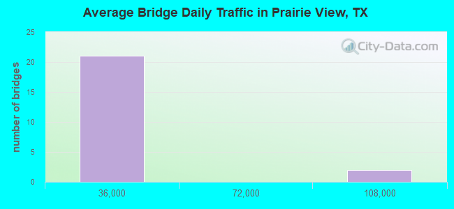
- 389,189Total average daily traffic
- 41,046Total average daily truck traffic
- National Bridge Inventory (NBI) Registered Bridges for Prairie View
- No street view available for this location
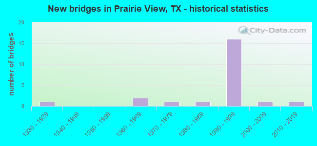
- New bridges - historical statistics
- 11930-1939
- 21960-1969
- 11970-1979
- 11980-1989
- 161990-1999
- 12000-2009
- 12010-2019
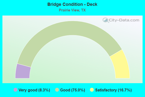
- Bridge Condition - Deck
- 8.3%Very good
- 75.0%Good
- 16.7%Satisfactory
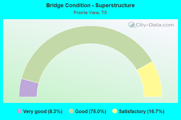
- Bridge Condition - Superstructure
- 8.3%Very good
- 75.0%Good
- 16.7%Satisfactory
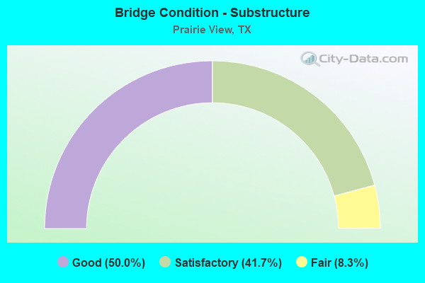
- Bridge Condition - Substructure
- 50.0%Good
- 41.7%Satisfactory
- 8.3%Fair
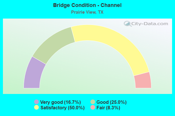
- Bridge Condition - Channel
- 16.7%Very good
- 25.0%Good
- 50.0%Satisfactory
- 8.3%Fair
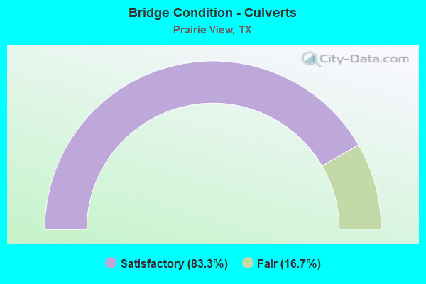
- Bridge Condition - Culverts
- 83.3%Satisfactory
- 16.7%Fair
Find on map >> Show street view
Structure Number: 122370005005023, Location: 2.40 MI W OF FM 362 (Lat: 30.068019, Lng: -95.974267), Route carried "on" structure: State highway 290, Year Built: 1930, Year Reconstructed: 1963, Status: Open, Structure Length: 0.67m (2.20ft), Average Daily Traffic: 3,810 (year 2013), Truck Traffic: 8%, Average Future Daily Traffic: 5,340 (year 2033), Design Load: H 15, Features Intersected: MOUND CRK TRIB
Minimum Vertical Clearance: 30+ m (98+ ft), Kilometerpoint: 12.609, Lanes on structure: 4, Owner: State Highway Agency, Approaching Roadway Width: 14.6m (47.9ft), Material/Design: Concrete, Design/Construction: Culvert, Number Of Spans In Main Unit: 5, Length of Maximum Span: 1.2m (3.9ft)
Condition: Channel: Satisfactory, Culverts: Fair, Operating Rating: 39.9 metric tons, Method Used To Determine Operating Rating: Load Factor (LF), Inventory Rating: 23.6 metric tons, Method Used To Determine Inventory Rating: Load Factor (LF), Structural Evaluation: Somewhat better than minimum adequacy, Waterway Adequacy: Equal to present minimum criteria, Approach Roadway Alignment: Equal to present desirable criteria, Length Of Structure Improvement: 0.67m (2.20ft), Designated Inspection Frequency: Every 24 months, Inspection Date: August 2020, Bridge Improvement Cost: $2,000, Roadway Improvement Cost: $1,000, Total Project Cost: $3,000
Find on map >> Show street view
Structure Number: 122370011411152, Location: 4.3 MI W OF FM 362 (Lat: 30.084183, Lng: -96.004217), Route carried "on" structure: City street , Year Built: 1996, Status: Open, Structure Length: 10.97m (35.99ft), Average Daily Traffic: 1,000 (year 2014), Truck Traffic: 5%, Average Future Daily Traffic: 3,000 (year 2034), Design Load: HS 20, Features Intersected: US 290, Facility Carried by Structure: RICHARDS RD
Minimum Vertical Clearance: 30+ m (98+ ft), Kilometerpoint: 0.002, Lanes on structure: 4, Lanes under structure: 4, Owner: State Highway Agency, Approaching Roadway Width: 19.5m (64.0ft), Material/Design: Prestressed concrete, Design/Construction: Stringer/Multi-beam, Number Of Spans In Main Unit: 2, Number Of Approach Spans: 2, Length of Maximum Span: 36.6m (120.1ft), Curb-To-Curb Width: 19.5m (64.0ft), Out-to-Out Width: 20.4m (66.9ft)
Condition: Deck: Good, Superstructure: Satisfactory, Substructure: Good, Operating Rating: 54.4 metric tons, Method Used To Determine Operating Rating: Assigned rating based on Load Factor Design (LFD) reported in metric tons, Inventory Rating: 32.7 metric tons, Method Used To Determine Inventory Rating: Assigned rating based on Load Factor Design (LFD) reported in metric tons, Structural Evaluation: Equal to present minimum criteria, Deck Geometry: Better than present minimum criteria, Underclear: Equal to present minimum criteria, Approach Roadway Alignment: Equal to present desirable criteria, Designated Inspection Frequency: Every 24 months, Inspection Date: August 2020, Deck Structure Type: Concrete Precast Panels
Find on map >> Show street view
Structure Number: 122370011411162, Location: 4.80 MI W OF FM 362 (Lat: 30.087433, Lng: -96.011556), Route carried "on" structure: US 290, Year Built: 1996, Status: Open, Structure Length: 9.75m (31.99ft), Average Daily Traffic: 22,529 (year 2019), Truck Traffic: 16%, Average Future Daily Traffic: 24,770 (year 2033), Design Load: HS 20, Features Intersected: LIENDO PARKWAY
Minimum Vertical Clearance: 30+ m (98+ ft), Kilometerpoint: 0.002, Lanes on structure: 2, Lanes under structure: 5, Owner: State Highway Agency, Approaching Roadway Width: 14.6m (47.9ft), Skew: 3 degrees, Material/Design: Prestressed concrete, Design/Construction: Stringer/Multi-beam, Number Of Spans In Main Unit: 3, Length of Maximum Span: 36.6m (120.1ft), Curb-To-Curb Width: 14.6m (47.9ft), Out-to-Out Width: 15.5m (50.9ft)
Condition: Deck: Good, Superstructure: Good, Substructure: Satisfactory, Operating Rating: 54.4 metric tons, Method Used To Determine Operating Rating: Assigned rating based on Load Factor Design (LFD) reported in metric tons, Inventory Rating: 32.7 metric tons, Method Used To Determine Inventory Rating: Assigned rating based on Load Factor Design (LFD) reported in metric tons, Structural Evaluation: Equal to present minimum criteria, Deck Geometry: Superior to present desirable criteria, Underclear: Equal to present minimum criteria, Approach Roadway Alignment: Equal to present desirable criteria, Designated Inspection Frequency: Every 24 months, Inspection Date: August 2020, Deck Structure Type: Concrete Precast Panels
Find on map >> Show street view
Structure Number: 122370011411163, Location: 4.80 MI W OF FM 362 (Lat: 30.087306, Lng: -96.012450), Route carried "on" structure: US 290, Year Built: 1996, Status: Open, Structure Length: 9.75m (31.99ft), Average Daily Traffic: 20,891 (year 2019), Truck Traffic: 16%, Average Future Daily Traffic: 24,770 (year 2033), Design Load: HS 20, Features Intersected: LIENDO PARKWAY
Minimum Vertical Clearance: 30+ m (98+ ft), Kilometerpoint: 18.334, Lanes on structure: 2, Lanes under structure: 5, Owner: State Highway Agency, Approaching Roadway Width: 14.6m (47.9ft), Skew: 3 degrees, Material/Design: Prestressed concrete, Design/Construction: Stringer/Multi-beam, Number Of Spans In Main Unit: 3, Length of Maximum Span: 36.6m (120.1ft), Curb-To-Curb Width: 14.6m (47.9ft), Out-to-Out Width: 15.5m (50.9ft)
Condition: Deck: Satisfactory, Superstructure: Good, Substructure: Fair, Operating Rating: 54.4 metric tons, Method Used To Determine Operating Rating: Assigned rating based on Load Factor Design (LFD) reported in metric tons, Inventory Rating: 32.7 metric tons, Method Used To Determine Inventory Rating: Assigned rating based on Load Factor Design (LFD) reported in metric tons, Structural Evaluation: Somewhat better than minimum adequacy, Deck Geometry: Superior to present desirable criteria, Underclear: Equal to present minimum criteria, Approach Roadway Alignment: Equal to present desirable criteria, Designated Inspection Frequency: Every 24 months, Inspection Date: August 2020, Deck Structure Type: Concrete Precast Panels
Find on map >> Show street view
Structure Number: 122370011411164, Location: 3.40 MI W OF FM 362 (Lat: 30.080244, Lng: -95.990892), Route carried "on" structure: State highway 1098, Year Built: 1996, Status: Open, Structure Length: 7.62m (25.00ft), Average Daily Traffic: 5,700 (year 2013), Truck Traffic: 9%, Average Future Daily Traffic: 7,980 (year 2033), Design Load: HS 20, Features Intersected: US 290
Minimum Vertical Clearance: 30+ m (98+ ft), Kilometerpoint: 22.243, Lanes on structure: 6, Lanes under structure: 4, Owner: State Highway Agency, Approaching Roadway Width: 30.5m (100.1ft), Skew: 1 degrees, Material/Design: Prestressed concrete, Design/Construction: Stringer/Multi-beam, Number Of Spans In Main Unit: 2, Length of Maximum Span: 38.1m (125.0ft), Curb-To-Curb Width: 30.5m (100.1ft), Out-to-Out Width: 31.3m (102.7ft)
Condition: Deck: Good, Superstructure: Good, Substructure: Good, Operating Rating: 54.4 metric tons, Method Used To Determine Operating Rating: Assigned rating based on Load Factor Design (LFD) reported in metric tons, Inventory Rating: 32.7 metric tons, Method Used To Determine Inventory Rating: Assigned rating based on Load Factor Design (LFD) reported in metric tons, Structural Evaluation: Better than present minimum criteria, Deck Geometry: Superior to present desirable criteria, Underclear: Better than present minimum criteria, Approach Roadway Alignment: Equal to present desirable criteria, Designated Inspection Frequency: Every 24 months, Inspection Date: August 2020, Deck Structure Type: Concrete Precast Panels
Find on map >> Show street view
Structure Number: 122370011411165, Location: 2.00 MI W OF FM 362 (Lat: 30.076739, Lng: -95.967369), Route carried "on" structure: US 290, Year Built: 1996, Status: Open, Structure Length: 9.75m (31.99ft), Average Daily Traffic: 20,100 (year 2013), Truck Traffic: 16%, Average Future Daily Traffic: 28,140 (year 2033), Design Load: HS 20, Features Intersected: JAMES MUSE PARKWAY
Minimum Vertical Clearance: 30+ m (98+ ft), Kilometerpoint: 22.804, Lanes on structure: 2, Lanes under structure: 5, Owner: State Highway Agency, Approaching Roadway Width: 14.6m (47.9ft), Material/Design: Prestressed concrete, Design/Construction: Stringer/Multi-beam, Number Of Spans In Main Unit: 3, Length of Maximum Span: 36.6m (120.1ft), Curb-To-Curb Width: 14.6m (47.9ft), Out-to-Out Width: 15.5m (50.9ft)
Condition: Deck: Good, Superstructure: Good, Substructure: Good, Operating Rating: 54.4 metric tons, Method Used To Determine Operating Rating: Assigned rating based on Load Factor Design (LFD) reported in metric tons, Inventory Rating: 32.7 metric tons, Method Used To Determine Inventory Rating: Assigned rating based on Load Factor Design (LFD) reported in metric tons, Structural Evaluation: Better than present minimum criteria, Deck Geometry: Superior to present desirable criteria, Underclear: Somewhat better than minimum adequacy, Approach Roadway Alignment: Equal to present desirable criteria, Designated Inspection Frequency: Every 24 months, Inspection Date: August 2020, Deck Structure Type: Concrete Precast Panels
Find on map >> Show street view
Structure Number: 122370011411166, Location: 2.00 MI W OF FM 362 (Lat: 30.076497, Lng: -95.968481), Route carried "on" structure: US 290, Year Built: 1996, Status: Open, Structure Length: 9.75m (31.99ft), Average Daily Traffic: 20,100 (year 2013), Truck Traffic: 16%, Average Future Daily Traffic: 28,140 (year 2033), Design Load: HS 20, Features Intersected: JAMES MUSE PARKWAY
Minimum Vertical Clearance: 30+ m (98+ ft), Kilometerpoint: 22.804, Lanes on structure: 2, Lanes under structure: 5, Owner: State Highway Agency, Approaching Roadway Width: 14.6m (47.9ft), Material/Design: Prestressed concrete, Design/Construction: Stringer/Multi-beam, Number Of Spans In Main Unit: 3, Length of Maximum Span: 36.6m (120.1ft), Curb-To-Curb Width: 14.6m (47.9ft), Out-to-Out Width: 15.5m (50.9ft)
Condition: Deck: Satisfactory, Superstructure: Satisfactory, Substructure: Satisfactory, Operating Rating: 54.4 metric tons, Method Used To Determine Operating Rating: Assigned rating based on Load Factor Design (LFD) reported in metric tons, Inventory Rating: 32.7 metric tons, Method Used To Determine Inventory Rating: Assigned rating based on Load Factor Design (LFD) reported in metric tons, Structural Evaluation: Equal to present minimum criteria, Deck Geometry: Superior to present desirable criteria, Underclear: Somewhat better than minimum adequacy, Approach Roadway Alignment: Equal to present desirable criteria, Designated Inspection Frequency: Every 24 months, Inspection Date: August 2020, Deck Structure Type: Concrete Precast Panels
Find on map >> Show street view
Structure Number: 122370052301021, Location: 2.30 MI N OF US 290 (Lat: 30.096644, Lng: -95.998092), Route carried "on" structure: State highway 1098, Year Built: 1976, Status: Open, Structure Length: 4.88m (16.01ft), Average Daily Traffic: 4,134 (year 2019), Truck Traffic: 9%, Average Future Daily Traffic: 3,960 (year 2033), Design Load: HS 20, Features Intersected: PONDS CREEK
Minimum Vertical Clearance: 30+ m (98+ ft), Kilometerpoint: 19.628, Lanes on structure: 2, Owner: State Highway Agency, Approaching Roadway Width: 13.4m (44.0ft), Material/Design: Concrete, Design/Construction: Stringer/Multi-beam, Number Of Spans In Main Unit: 4, Length of Maximum Span: 12.2m (40.0ft), Curb-To-Curb Width: 14.6m (47.9ft), Out-to-Out Width: 15.1m (49.5ft)
Condition: Deck: Good, Superstructure: Good, Substructure: Good, Channel: Good, Operating Rating: 68.0 metric tons, Method Used To Determine Operating Rating: Load Factor (LF), Inventory Rating: 40.8 metric tons, Method Used To Determine Inventory Rating: Load Factor (LF), Structural Evaluation: Better than present minimum criteria, Deck Geometry: Superior to present desirable criteria, Waterway Adequacy: Equal to present minimum criteria, Approach Roadway Alignment: Equal to present desirable criteria, Designated Inspection Frequency: Every 24 months, Inspection Date: August 2020, Deck Structure Type: Concrete Cast-file-Place
Find on map >> Show street view
Structure Number: 122370052304026, Location: 0.80 MI E OF FM 362 (Lat: 30.148339, Lng: -95.944597), Route carried "on" structure: State highway 1488, Year Built: 1990, Status: Open, Structure Length: 2.74m (8.99ft), Average Daily Traffic: 4,920 (year 2020), Truck Traffic: 9%, Average Future Daily Traffic: 6,230 (year 2033), Design Load: HS 20, Features Intersected: SPRING CREEK
Minimum Vertical Clearance: 30+ m (98+ ft), Kilometerpoint: 15.089, Lanes on structure: 2, Owner: State Highway Agency, Approaching Roadway Width: 9.8m (32.2ft), Material/Design: Prestressed concrete, Number Of Spans In Main Unit: 3, Length of Maximum Span: 9.1m (29.9ft), Curb-To-Curb Width: 13.9m (45.6ft), Out-to-Out Width: 14.7m (48.2ft)
Condition: Deck: Good, Superstructure: Good, Substructure: Satisfactory, Channel: Very good, Operating Rating: 54.4 metric tons, Method Used To Determine Operating Rating: Assigned rating based on Load Factor Design (LFD) reported in metric tons, Inventory Rating: 32.7 metric tons, Method Used To Determine Inventory Rating: Assigned rating based on Load Factor Design (LFD) reported in metric tons, Structural Evaluation: Equal to present minimum criteria, Deck Geometry: Superior to present desirable criteria, Waterway Adequacy: Equal to present desirable criteria, Approach Roadway Alignment: Equal to present desirable criteria, Designated Inspection Frequency: Every 24 months, Inspection Date: August 2020, Deck Structure Type: Concrete Cast-file-Place
Find on map >> Show street view
Structure Number: 122370AA0208005, Location: 0.8 MI S OF BUS 290 (Lat: 30.054553, Lng: -95.967411), Route carried "on" structure: County highway , Year Built: 1990, Status: Open, Structure Length: 0.64m (2.10ft), Average Daily Traffic: 887 (year 2016), Average Future Daily Traffic: 1,160 (year 2031), Features Intersected: Mound Creek, Facility Carried by Structure: Blinka Rd
Minimum Vertical Clearance: 30+ m (98+ ft), Kilometerpoint: 1.287, Lanes on structure: 2, Owner: County Highway Agency, Approaching Roadway Width: 6.7m (22.0ft), Material/Design: Concrete, Design/Construction: Culvert, Number Of Spans In Main Unit: 4, Length of Maximum Span: 1.5m (4.9ft), Curb-To-Curb Width: 9.2m (30.2ft), Out-to-Out Width: 9.5m (31.2ft)
Condition: Channel: Good, Culverts: Satisfactory, Operating Rating: 32.7 metric tons, Method Used To Determine Operating Rating: Field evaluation and documented engineering judgment, Inventory Rating: 24.5 metric tons, Method Used To Determine Inventory Rating: Field evaluation and documented engineering judgment, Structural Evaluation: Equal to present minimum criteria, Deck Geometry: Equal to present minimum criteria, Waterway Adequacy: Better than present minimum criteria, Approach Roadway Alignment: Equal to present desirable criteria, Designated Inspection Frequency: Every 24 months, Inspection Date: November 2021, Deck Structure Type: Concrete Cast-file-Place, Wearing Surface/Protective System: Wearing Surface: Bituminous
Find on map >> Show street view
Structure Number: 122370AA0284001, Location: 1.70 MI S OF FM 1736 (Lat: 30.143103, Lng: -96.013314), Route carried "on" structure: County highway , Year Built: 2013, Status: Open, Structure Length: 1.52m (4.99ft), Average Daily Traffic: 738 (year 2010), Average Future Daily Traffic: 1,408 (year 2030), Design Load: HL 93, Features Intersected: CLEAR CREEK, Facility Carried by Structure: LANEVIEW RD
Minimum Vertical Clearance: 30+ m (98+ ft), Kilometerpoint: 4.667, Lanes on structure: 2, Owner: County Highway Agency, Approaching Roadway Width: 6.7m (22.0ft), Material/Design: Prestressed concrete, Number Of Spans In Main Unit: 1, Length of Maximum Span: 14.9m (48.9ft), Curb-To-Curb Width: 9.1m (29.9ft), Out-to-Out Width: 9.1m (29.9ft)
Condition: Deck: Good, Superstructure: Very good, Substructure: Good, Channel: Very good, Operating Rating: 54.4 metric tons, Method Used To Determine Operating Rating: Assigned ratings based on Load and Resistance Factor Design (LRFD) reported in metric tons, Inventory Rating: 32.7 metric tons, Method Used To Determine Inventory Rating: Assigned ratings based on Load and Resistance Factor Design (LRFD) reported in metric tons, Structural Evaluation: Better than present minimum criteria, Deck Geometry: Equal to present minimum criteria, Waterway Adequacy: Better than present minimum criteria, Approach Roadway Alignment: Equal to present desirable criteria, Length Of Structure Improvement: 1.89m (6.20ft), Designated Inspection Frequency: Every 24 months, Inspection Date: October 2021, Bridge Improvement Cost: $5,000, Roadway Improvement Cost: $1,000, Total Project Cost: $6,000, Deck Structure Type: Concrete Cast-file-Place
Find on map >> Show street view
Structure Number: 122370AA0303001, Location: 0.70 MI E OF FM 1736 (Lat: 30.154581, Lng: -95.986397), Route carried "on" structure: County highway , Year Built: 2004, Status: Open, Structure Length: 0.79m (2.59ft), Average Daily Traffic: 70 (year 2009), Average Future Daily Traffic: 150 (year 2029), Features Intersected: CLEAR CREEK DRAW, Facility Carried by Structure: TOMPKINS RD
Minimum Vertical Clearance: 30+ m (98+ ft), Kilometerpoint: 1.143, Lanes on structure: 2, Owner: County Highway Agency, Approaching Roadway Width: 5.2m (17.1ft), Skew: 3 degrees, Material/Design: Steel, Design/Construction: Culvert, Number Of Spans In Main Unit: 2, Length of Maximum Span: 2.7m (8.9ft)
Condition: Channel: Satisfactory, Culverts: Satisfactory, Operating Rating: 32.7 metric tons, Method Used To Determine Operating Rating: Field evaluation and documented engineering judgment, Inventory Rating: 24.5 metric tons, Method Used To Determine Inventory Rating: Field evaluation and documented engineering judgment, Structural Evaluation: Equal to present minimum criteria, Waterway Adequacy: Better than present minimum criteria, Approach Roadway Alignment: Equal to present desirable criteria, Designated Inspection Frequency: Every 24 months, Inspection Date: October 2021
Find on map >> Show street view
Structure Number: 122370AA0304001, Location: 1.30 MI N OF FM 1488 (Lat: 30.149886, Lng: -95.980903), Route carried "on" structure: County highway , Year Built: 1984, Status: Open, Structure Length: 0.98m (3.22ft), Average Daily Traffic: 100 (year 2009), Average Future Daily Traffic: 150 (year 2029), Features Intersected: CLEAR CREEK, Facility Carried by Structure: MITCHELL RD
Minimum Vertical Clearance: 30+ m (98+ ft), Kilometerpoint: 2.044, Lanes on structure: 2, Owner: County Highway Agency, Approaching Roadway Width: 5.5m (18.0ft), Material/Design: Prestressed concrete, Number Of Spans In Main Unit: 1, Length of Maximum Span: 9.4m (30.8ft), Curb-To-Curb Width: 6.9m (22.6ft), Out-to-Out Width: 7.3m (24.0ft)
Condition: Deck: Good, Superstructure: Good, Substructure: Satisfactory, Channel: Satisfactory, Operating Rating: 32.7 metric tons, Method Used To Determine Operating Rating: Field evaluation and documented engineering judgment, Inventory Rating: 24.5 metric tons, Method Used To Determine Inventory Rating: Field evaluation and documented engineering judgment, Structural Evaluation: Equal to present minimum criteria, Deck Geometry: Somewhat better than minimum adequacy, Waterway Adequacy: Better than present minimum criteria, Approach Roadway Alignment: Equal to present minimum criteria, Designated Inspection Frequency: Every 24 months, Inspection Date: October 2021, Deck Structure Type: Concrete Cast-file-Place, Wearing Surface/Protective System: Wearing Surface: Bituminous
Find on map >> Show street view
Structure Number: 122370AA0322001, Location: 0.80 MI W OF FM 1098 (Lat: 30.104336, Lng: -96.011000), Route carried "on" structure: County highway , Year Built: 1999, Status: Open, Structure Length: 0.64m (2.10ft), Average Daily Traffic: 1,512 (year 2016), Average Future Daily Traffic: 1,535 (year 2029), Features Intersected: PONDS CREEK DRAW, Facility Carried by Structure: WYATT CHAPEL RD
Minimum Vertical Clearance: 30+ m (98+ ft), Kilometerpoint: 0.628, Lanes on structure: 2, Owner: County Highway Agency, Approaching Roadway Width: 7.3m (24.0ft), Material/Design: Steel, Design/Construction: Culvert, Number Of Spans In Main Unit: 2, Length of Maximum Span: 2.7m (8.9ft)
Condition: Channel: Satisfactory, Culverts: Satisfactory, Operating Rating: 32.7 metric tons, Method Used To Determine Operating Rating: Field evaluation and documented engineering judgment, Inventory Rating: 24.5 metric tons, Method Used To Determine Inventory Rating: Field evaluation and documented engineering judgment, Structural Evaluation: Equal to present minimum criteria, Waterway Adequacy: Better than present minimum criteria, Approach Roadway Alignment: Better than present minimum criteria, Designated Inspection Frequency: Every 24 months, Inspection Date: October 2021
Find on map >> Show street view
Structure Number: 122370AA2693005, Location: 0.3 MI N OF US 290 (Lat: 30.092953, Lng: -96.012425), Route carried "on" structure: County highway , Year Built: 1990, Status: Open, Structure Length: 1.62m (5.31ft), Average Daily Traffic: 638 (year 2016), Average Future Daily Traffic: 800 (year 2036), Features Intersected: Ponds Creek, Facility Carried by Structure: Liendo Pkwy.
Minimum Vertical Clearance: 30+ m (98+ ft), Kilometerpoint: 1.770, Lanes on structure: 2, Owner: County Highway Agency, Approaching Roadway Width: 7.3m (24.0ft), Skew: 1 degrees, Material/Design: Steel, Design/Construction: Culvert, Number Of Spans In Main Unit: 5, Length of Maximum Span: 2.6m (8.5ft), Curb-To-Curb Width: 12.1m (39.7ft), Out-to-Out Width: 15.3m (50.2ft)
Condition: Channel: Satisfactory, Culverts: Satisfactory, Operating Rating: 32.7 metric tons, Method Used To Determine Operating Rating: Field evaluation and documented engineering judgment, Inventory Rating: 24.5 metric tons, Method Used To Determine Inventory Rating: Field evaluation and documented engineering judgment, Structural Evaluation: Equal to present minimum criteria, Deck Geometry: Better than present minimum criteria, Waterway Adequacy: Better than present minimum criteria, Approach Roadway Alignment: Equal to present desirable criteria, Designated Inspection Frequency: Every 24 months, Inspection Date: November 2021, Deck Structure Type: Corrugated Steel
Find on map >> Show street view
Structure Number: 122370B00020001, Location: 0.7 MI S OF WYATT CHAPEL (Lat: 30.091775, Lng: -96.004000), Route carried "on" structure: City street , Year Built: 1995, Status: Open, Structure Length: 2.74m (8.99ft), Average Daily Traffic: 300 (year 2009), Average Future Daily Traffic: 500 (year 2029), Features Intersected: PONDS CREEK, Facility Carried by Structure: RICHARDS RD
Minimum Vertical Clearance: 30+ m (98+ ft), Kilometerpoint: 1.931, Lanes on structure: 2, Owner: Town or Township Highway Agency, Approaching Roadway Width: 6.7m (22.0ft), Material/Design: Prestressed concrete, Design/Construction: Stringer/Multi-beam, Number Of Spans In Main Unit: 2, Length of Maximum Span: 13.7m (44.9ft), Curb-To-Curb Width: 8.5m (27.9ft), Out-to-Out Width: 9.4m (30.8ft)
Condition: Deck: Very good, Superstructure: Good, Substructure: Good, Channel: Good, Operating Rating: 57.1 metric tons, Method Used To Determine Operating Rating: Load Factor (LF), Inventory Rating: 34.5 metric tons, Method Used To Determine Inventory Rating: Load Factor (LF), Structural Evaluation: Better than present minimum criteria, Deck Geometry: Equal to present minimum criteria, Waterway Adequacy: Better than present minimum criteria, Approach Roadway Alignment: Better than present minimum criteria, Designated Inspection Frequency: Every 24 months, Inspection Date: October 2021, Deck Structure Type: Concrete Cast-file-Place
Find on map >> Show street view
Structure Number: 122370B00335001, Location: 0.20 MI SE OF FM 1098 (Lat: 30.103108, Lng: -95.987464), Route carried "on" structure: City street , Year Built: 1960, Status: Open, Structure Length: 2.35m (7.71ft), Average Daily Traffic: 530 (year 2009), Average Future Daily Traffic: 850 (year 2029), Features Intersected: PONDS CREEK, Facility Carried by Structure: CAMERON RD
Minimum Vertical Clearance: 30+ m (98+ ft), Kilometerpoint: 0.322, Lanes on structure: 2, Owner: Town or Township Highway Agency, Approaching Roadway Width: 5.5m (18.0ft), Material/Design: Concrete, Design/Construction: Slab, Number Of Spans In Main Unit: 3, Length of Maximum Span: 7.6m (24.9ft), Curb-To-Curb Width: 5.9m (19.4ft), Out-to-Out Width: 6.5m (21.3ft)
Condition: Deck: Good, Superstructure: Good, Substructure: Satisfactory, Channel: Fair, Operating Rating: 32.7 metric tons, Method Used To Determine Operating Rating: Field evaluation and documented engineering judgment, Inventory Rating: 24.5 metric tons, Method Used To Determine Inventory Rating: Field evaluation and documented engineering judgment, Structural Evaluation: Equal to present minimum criteria, Deck Geometry: High priority of replacement, Waterway Adequacy: Better than present minimum criteria, Approach Roadway Alignment: Equal to present minimum criteria, Length Of Structure Improvement: 2.35m (7.71ft), Designated Inspection Frequency: Every 24 months, Inspection Date: October 2021, Bridge Improvement Cost: $3,000, Roadway Improvement Cost: $1,000, Total Project Cost: $4,000, Deck Structure Type: Concrete Cast-file-Place
Find on map >> Show street view
Structure Number: 122370B00340001, Location: 0.90 MI E OF COCHRAN RD (Lat: 30.067567, Lng: -95.974306), Route carried "on" structure: City street , Year Built: 1960, Status: Open, Structure Length: 0.67m (2.20ft), Average Daily Traffic: 680 (year 2009), Average Future Daily Traffic: 1,000 (year 2029), Features Intersected: DRAINAGE DITCH, Facility Carried by Structure: OLD HOUSTON HWY
Minimum Vertical Clearance: 30+ m (98+ ft), Kilometerpoint: 0.386, Lanes on structure: 2, Owner: Town or Township Highway Agency, Approaching Roadway Width: 7.3m (24.0ft), Material/Design: Concrete, Design/Construction: Culvert, Number Of Spans In Main Unit: 4, Length of Maximum Span: 1.5m (4.9ft), Curb-To-Curb Width: 9.5m (31.2ft), Out-to-Out Width: 9.8m (32.2ft)
Condition: Channel: Satisfactory, Culverts: Satisfactory, Operating Rating: 32.7 metric tons, Method Used To Determine Operating Rating: Field evaluation and documented engineering judgment, Inventory Rating: 24.5 metric tons, Method Used To Determine Inventory Rating: Field evaluation and documented engineering judgment, Structural Evaluation: Equal to present minimum criteria, Deck Geometry: Equal to present minimum criteria, Waterway Adequacy: Better than present minimum criteria, Approach Roadway Alignment: Equal to present desirable criteria, Designated Inspection Frequency: Every 24 months, Inspection Date: October 2021, Deck Structure Type: Concrete Cast-file-Place, Wearing Surface/Protective System: Wearing Surface: Bituminous
Find on map >> Show street view
Structure Number: 122370011411152, Location: 4.3 MI W OF FM 362 (Lat: 30.084183, Lng: -96.004217), Route carried "under" structure: US 290, Year Built: 1996, Structure Length: 0. m, Average Daily Traffic: 35,380 (year 2013), Truck Traffic: 16%, Features Intersected: US 290, Facility Carried by Structure: RICHARDS RD
Minimum Vertical Clearance: 5.16m (16.93ft), Kilometerpoint: 19.191, Material/Design: Prestressed concrete, Design/Construction: Stringer/Multi-beam, Length of Maximum Span: 36.6m (120.1ft)
Structure Number: 122370011411162, Location: 4.80 MI W OF FM 362, Route carried "under" structure: City street , Year Built: 1996, Structure Length: 0. m, Average Daily Traffic: 10,000 (year 2010), Truck Traffic: 7%, Features Intersected: LIENDO PARKWAY, Facility Carried by Structure: US 290 WB
Minimum Vertical Clearance: 5.26m (17.26ft), Kilometerpoint: 18.303, Material/Design: Prestressed concrete, Design/Construction: Stringer/Multi-beam, Length of Maximum Span: 36.6m (120.1ft)
Minimum Vertical Clearance: 5.26m (17.26ft), Kilometerpoint: 18.303, Material/Design: Prestressed concrete, Design/Construction: Stringer/Multi-beam, Length of Maximum Span: 36.6m (120.1ft)
Structure Number: 122370011411163, Location: 4.80 MI W OF FM 362, Route carried "under" structure: City street , Year Built: 1996, Structure Length: 0. m, Average Daily Traffic: 100,000 (year 2011), Truck Traffic: 7%, Features Intersected: LIENDO PARKWAY, Facility Carried by Structure: US 290 EB
Minimum Vertical Clearance: 5.18m (16.99ft), Kilometerpoint: 18.303, Material/Design: Prestressed concrete, Design/Construction: Stringer/Multi-beam, Length of Maximum Span: 36.6m (120.1ft)
Minimum Vertical Clearance: 5.18m (16.99ft), Kilometerpoint: 18.303, Material/Design: Prestressed concrete, Design/Construction: Stringer/Multi-beam, Length of Maximum Span: 36.6m (120.1ft)
Find on map >> Show street view
Structure Number: 122370011411164, Location: 3.40 MI W OF FM 362 (Lat: 30.080244, Lng: -95.990892), Route carried "under" structure: US 290, Year Built: 1996, Structure Length: 0. m, Average Daily Traffic: 35,170 (year 2013), Truck Traffic: 16%, Features Intersected: US 290, Facility Carried by Structure: FM 1098
Minimum Vertical Clearance: 5.26m (17.26ft), Kilometerpoint: 20.577, Material/Design: Prestressed concrete, Design/Construction: Stringer/Multi-beam, Length of Maximum Span: 38.1m (125.0ft)
Structure Number: 122370011411166, Location: 2.00 MI W OF FM 362, Route carried "under" structure: City street , Year Built: 1996, Structure Length: 0. m, Average Daily Traffic: 100,000 (year 2010), Truck Traffic: 7%, Features Intersected: JAMES MUSE PARKWAY, Facility Carried by Structure: US 290 EB
Minimum Vertical Clearance: 5.54m (18.18ft), Kilometerpoint: 22.788, Material/Design: Prestressed concrete, Design/Construction: Stringer/Multi-beam, Length of Maximum Span: 36.6m (120.1ft)
Minimum Vertical Clearance: 5.54m (18.18ft), Kilometerpoint: 22.788, Material/Design: Prestressed concrete, Design/Construction: Stringer/Multi-beam, Length of Maximum Span: 36.6m (120.1ft)