Bridge Statistics for Price, Utah (UT)
Condition, Traffic, Stress, Structural Evaluation, Project Costs
- National Bridge Inventory (NBI) Statistics
- 17Number of bridges
- 180ft / 54.9mTotal length
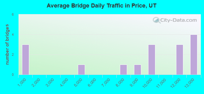
- 136,152Total average daily traffic
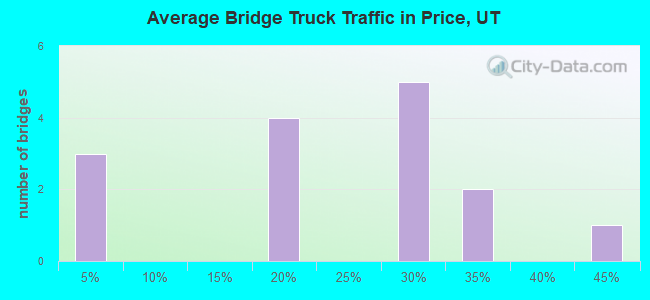
- 33,986Total average daily truck traffic
- National Bridge Inventory (NBI) Registered Bridges for Price
- No street view available for this location
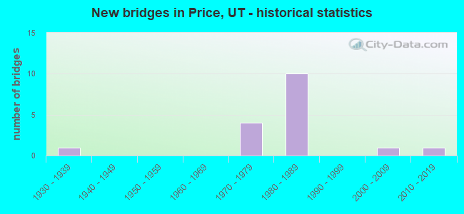
- New bridges - historical statistics
- 11930-1939
- 41970-1979
- 101980-1989
- 12000-2009
- 12010-2019
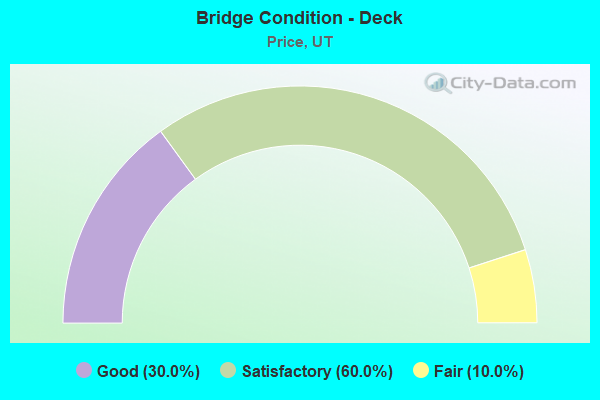
- Bridge Condition - Deck
- 30.0%Good
- 60.0%Satisfactory
- 10.0%Fair
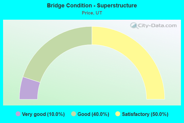
- Bridge Condition - Superstructure
- 10.0%Very good
- 40.0%Good
- 50.0%Satisfactory
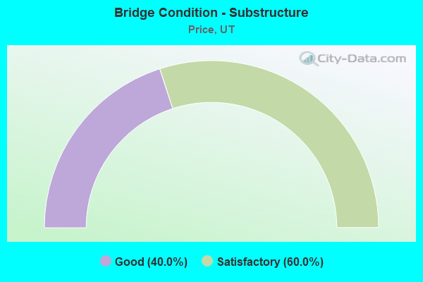
- Bridge Condition - Substructure
- 40.0%Good
- 60.0%Satisfactory
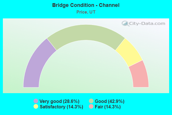
- Bridge Condition - Channel
- 28.6%Very good
- 42.9%Good
- 14.3%Satisfactory
- 14.3%Fair
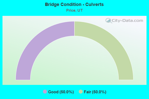
- Bridge Condition - Culverts
- 50.0%Good
- 50.0%Fair
Find on map >> Show street view
Structure Number: 7009D, Location: 2 MILES SOUTH OF PRICE (Lat: 39.556964, Lng: -110.813072), Route carried "on" structure: County highway , Year Built: 1975, Status: Posted for load, Structure Length: 1.04m (3.41ft), Average Daily Traffic: 126 (year 2020), Truck Traffic: 1%, Average Future Daily Traffic: 153 (year 2040), Design Load: HL 93, Features Intersected: CARBON CANAL, Facility Carried by Structure: COUNTY ROAD
Minimum Vertical Clearance: 30+ m (98+ ft), Kilometerpoint: 0.240, Lanes on structure: 2, Owner: County Highway Agency, Approaching Roadway Width: 6.1m (20.0ft), Skew: 2 degrees, Material/Design: Concrete, Design/Construction: Slab, Number Of Spans In Main Unit: 1, Length of Maximum Span: 7.5m (24.6ft), Curb-To-Curb Width: 6.1m (20.0ft), Out-to-Out Width: 7.5m (24.6ft)
Condition: Deck: Good, Superstructure: Good, Substructure: Good, Channel: Fair, Operating Rating: 47.0 metric tons, Method Used To Determine Operating Rating: Load and Resistance Factor Rating (LRFR) rating reported by rating factor(RF) method using HL-93 loadings, Inventory Rating: 32.4 metric tons, Method Used To Determine Inventory Rating: Load Factor (LF) rating reported by rating factor (RF) method using MS18 loading, Structural Evaluation: Better than present minimum criteria, Deck Geometry: Meets minimum limits, Waterway Adequacy: Somewhat better than minimum adequacy, Approach Roadway Alignment: Equal to present desirable criteria, Designated Inspection Frequency: Every 22 months, Inspection Date: August 2020, Deck Structure Type: Concrete Cast-file-Place, Wearing Surface/Protective System: Wearing Surface: Monolithic Concrete
Find on map >> Show street view
Structure Number: 7012V, Location: 650 NO.CEDAR HILLS DRIVE (Lat: 39.610936, Lng: -110.792919), Route carried "on" structure: City street , Year Built: 1982, Status: Open, Structure Length: 0.78m (2.56ft), Average Daily Traffic: 315 (year 2020), Truck Traffic: 1%, Average Future Daily Traffic: 383 (year 2040), Design Load: HS 20+Mod, Features Intersected: MEADS WASH, Facility Carried by Structure: 650 NORTH STREET
Minimum Vertical Clearance: 30+ m (98+ ft), Kilometerpoint: 0.388, Lanes on structure: 2, Owner: City or Municipal Highway Agency, Approaching Roadway Width: 13.7m (44.9ft), Skew: 2 degrees, Material/Design: Steel, Design/Construction: Culvert, Number Of Spans In Main Unit: 2, Length of Maximum Span: 3.3m (10.8ft), Curb or Sidewalk Widths: Left: 1.2m (3.9ft), Right: 0.0m
Condition: Channel: Very good, Culverts: Fair, Operating Rating: 97.2 metric tons, Method Used To Determine Operating Rating: Load and Resistance Factor Rating (LRFR) rating reported by rating factor(RF) method using HL-93 loadings, Inventory Rating: 96.9 metric tons, Method Used To Determine Inventory Rating: Load and Resistance Factor Rating (LRFR) rating reported by rating factor(RF) method using HL-93 loadings, Structural Evaluation: Somewhat better than minimum adequacy, Waterway Adequacy: Equal to present minimum criteria, Approach Roadway Alignment: Better than present minimum criteria, Designated Inspection Frequency: Every 25 months, Inspection Date: May 2020
Find on map >> Show street view
Structure Number: 7034E, Location: 3.5 MILES SOUTH OF PRICE (Lat: 39.550061, Lng: -110.806539), Route carried "on" structure: County highway , Year Built: 2002, Status: Open, Structure Length: 0.70m (2.30ft), Average Daily Traffic: 202 (year 2020), Truck Traffic: 1%, Average Future Daily Traffic: 245 (year 2040), Design Load: HS 20+Mod, Features Intersected: CARBON CANAL, Facility Carried by Structure: 500 EAST STREET
Minimum Vertical Clearance: 30+ m (98+ ft), Kilometerpoint: 0.009, Lanes on structure: 2, Owner: County Highway Agency, Approaching Roadway Width: 8.7m (28.5ft), Material/Design: Concrete, Design/Construction: Culvert, Number Of Spans In Main Unit: 1, Length of Maximum Span: 6.4m (21.0ft), Curb-To-Curb Width: 8.7m (28.5ft), Out-to-Out Width: 9.6m (31.5ft)
Condition: Channel: Good, Culverts: Good, Operating Rating: 32.4 metric tons, Method Used To Determine Operating Rating: Load and Resistance Factor Rating (LRFR) rating reported by rating factor(RF) method using HL-93 loadings, Inventory Rating: 19.1 metric tons, Method Used To Determine Inventory Rating: Load and Resistance Factor Rating (LRFR) rating reported by rating factor(RF) method using HL-93 loadings, Structural Evaluation: Somewhat better than minimum adequacy, Deck Geometry: Equal to present minimum criteria, Waterway Adequacy: Equal to present desirable criteria, Approach Roadway Alignment: Equal to present minimum criteria, Designated Inspection Frequency: Every 22 months, Inspection Date: August 2020
Find on map >> Show street view
Structure Number: C 682, Location: WEST SIDE OF PRICE (Lat: 39.600925, Lng: -110.819517), Route carried "on" structure: State highway 55, Year Built: 1979, Status: Open, Structure Length: 20.71m (67.95ft), Average Daily Traffic: 8,913 (year 2020), Truck Traffic: 18%, Average Future Daily Traffic: 11,141 (year 2040), Design Load: HS 20+Mod, Features Intersected: CITY STREET AND UPRR
Minimum Vertical Clearance: 30+ m (98+ ft), Kilometerpoint: 0.755, Lanes on structure: 2, Lanes under structure: 4, Owner: State Highway Agency, Approaching Roadway Width: 13.1m (43.0ft), Material/Design: Steel continuous, Design/Construction: Stringer/Multi-beam, Number Of Spans In Main Unit: 5, Length of Maximum Span: 48.8m (160.1ft), Curb or Sidewalk Widths: Left: 0.0m, Right: 1.2m (3.9ft), Curb-To-Curb Width: 13.1m (43.0ft), Out-to-Out Width: 15.5m (50.9ft)
Condition: Deck: Good, Superstructure: Good, Substructure: Good, Operating Rating: 55.7 metric tons, Method Used To Determine Operating Rating: Load and Resistance Factor Rating (LRFR) rating reported by rating factor(RF) method using HL-93 loadings, Inventory Rating: 38.2 metric tons, Method Used To Determine Inventory Rating: Load Factor (LF) rating reported by rating factor (RF) method using MS18 loading, Structural Evaluation: Better than present minimum criteria, Deck Geometry: Somewhat better than minimum adequacy, Underclear: Equal to present minimum criteria, Approach Roadway Alignment: Equal to present minimum criteria, Designated Inspection Frequency: Every 24 months, Inspection Date: September 2021, Deck Structure Type: Concrete Cast-file-Place, Wearing Surface/Protective System: Wearing Surface: Bituminous, Membrane: Preformed Fabric, Deck Protection: Epoxy Coated Reinforcing
Find on map >> Show street view
Structure Number: C 722, Location: AT THE EAST PRICE INTCHG. (Lat: 39.587292, Lng: -110.792836), Route carried "on" structure: US 6, Year Built: 1982, Status: Open, Structure Length: 7.26m (23.82ft), Average Daily Traffic: 12,780 (year 2020), Truck Traffic: 31%, Average Future Daily Traffic: 15,975 (year 2040), Design Load: HS 20+Mod, Features Intersected: CITY STREET AND UPRR
Minimum Vertical Clearance: 30+ m (98+ ft), Kilometerpoint: 390.142, Lanes on structure: 3, Lanes under structure: 2, Base Highway Network: Yes, Owner: State Highway Agency, Approaching Roadway Width: 22.6m (74.1ft), Skew: 22 degrees, Material/Design: Steel continuous, Design/Construction: Stringer/Multi-beam, Number Of Spans In Main Unit: 4, Length of Maximum Span: 23.3m (76.4ft), Curb-To-Curb Width: 22.6m (74.1ft), Out-to-Out Width: 27.9m (91.5ft)
Condition: Deck: Fair, Superstructure: Satisfactory, Substructure: Satisfactory, Operating Rating: 34.0 metric tons, Method Used To Determine Operating Rating: Load and Resistance Factor Rating (LRFR) rating reported by rating factor(RF) method using HL-93 loadings, Inventory Rating: 25.3 metric tons, Method Used To Determine Inventory Rating: Load Factor (LF) rating reported by rating factor (RF) method using MS18 loading, Structural Evaluation: Equal to present minimum criteria, Deck Geometry: Superior to present desirable criteria, Underclear: Superior to present desirable criteria, Approach Roadway Alignment: Equal to present minimum criteria, Designated Inspection Frequency: Every 24 months, Inspection Date: September 2021, Deck Structure Type: Concrete Cast-file-Place, Wearing Surface/Protective System: Wearing Surface: Bituminous, Deck Protection: Epoxy Coated Reinforcing
Find on map >> Show street view
Structure Number: D 401, Location: SOUTH SIDE OF PRICE (Lat: 39.586711, Lng: -110.812686), Route carried "on" structure: State highway 10, Year Built: 1936, Year Reconstructed: 1982, Status: Open, Structure Length: 2.28m (7.48ft), Average Daily Traffic: 9,996 (year 2020), Truck Traffic: 25%, Average Future Daily Traffic: 12,495 (year 2040), Design Load: HS 20+Mod, Features Intersected: PRICE RIVER
Minimum Vertical Clearance: 30+ m (98+ ft), Kilometerpoint: 109.208, Lanes on structure: 5, Base Highway Network: Yes, Owner: State Highway Agency, Approaching Roadway Width: 25.2m (82.7ft), Material/Design: Concrete, Design/Construction: Frame, Number Of Spans In Main Unit: 1, Length of Maximum Span: 19.8m (65.0ft), Curb or Sidewalk Widths: Left: 0.0m, Right: 2.6m (8.5ft), Curb-To-Curb Width: 25.2m (82.7ft), Out-to-Out Width: 25.8m (84.6ft)
Condition: Deck: Satisfactory, Superstructure: Satisfactory, Substructure: Satisfactory, Channel: Satisfactory, Operating Rating: 49.9 metric tons, Method Used To Determine Operating Rating: Load and Resistance Factor Rating (LRFR) rating reported by rating factor(RF) method using HL-93 loadings, Inventory Rating: 26.6 metric tons, Method Used To Determine Inventory Rating: Load and Resistance Factor Rating (LRFR) rating reported by rating factor(RF) method using HL-93 loadings, Structural Evaluation: Equal to present minimum criteria, Deck Geometry: Superior to present desirable criteria, Waterway Adequacy: Better than present minimum criteria, Approach Roadway Alignment: Equal to present desirable criteria, Designated Inspection Frequency: Every 24 months, Inspection Date: September 2021, Deck Structure Type: Concrete Cast-file-Place, Wearing Surface/Protective System: Wearing Surface: Bituminous
Find on map >> Show street view
Structure Number: F 386, Location: 1 MILE WEST OF PRICE (Lat: 39.600872, Lng: -110.825903), Route carried "on" structure: State highway 55, Year Built: 1977, Status: Open, Structure Length: 4.72m (15.49ft), Average Daily Traffic: 12,511 (year 2020), Truck Traffic: 18%, Average Future Daily Traffic: 15,639 (year 2040), Design Load: HS 20+Mod, Features Intersected: PRICE RIVER
Minimum Vertical Clearance: 30+ m (98+ ft), Kilometerpoint: 0.206, Lanes on structure: 2, Owner: State Highway Agency, Approaching Roadway Width: 17.2m (56.4ft), Skew: 3 degrees, Material/Design: Prestressed concrete continuous, Design/Construction: Stringer/Multi-beam, Number Of Spans In Main Unit: 2, Length of Maximum Span: 23.2m (76.1ft), Curb or Sidewalk Widths: Left: 0.0m, Right: 2.4m (7.9ft), Curb-To-Curb Width: 17.2m (56.4ft), Out-to-Out Width: 18.3m (60.0ft)
Condition: Deck: Good, Superstructure: Good, Substructure: Good, Channel: Good, Operating Rating: 49.6 metric tons, Method Used To Determine Operating Rating: Load and Resistance Factor Rating (LRFR) rating reported by rating factor(RF) method using HL-93 loadings, Inventory Rating: 33.7 metric tons, Method Used To Determine Inventory Rating: Load Factor (LF) rating reported by rating factor (RF) method using MS18 loading, Structural Evaluation: Better than present minimum criteria, Deck Geometry: Superior to present desirable criteria, Waterway Adequacy: Equal to present minimum criteria, Approach Roadway Alignment: Equal to present desirable criteria, Designated Inspection Frequency: Every 24 months, Inspection Date: September 2021, Deck Structure Type: Concrete Cast-file-Place, Wearing Surface/Protective System: Wearing Surface: Bituminous, Membrane: Preformed Fabric
Find on map >> Show street view
Structure Number: F 388, Location: SOUTH SIDE OF PRICE CITY (Lat: 39.595653, Lng: -110.823167), Route carried "on" structure: US 6, Year Built: 1982, Status: Open, Structure Length: 3.31m (10.86ft), Average Daily Traffic: 11,591 (year 2020), Truck Traffic: 28%, Average Future Daily Traffic: 14,489 (year 2040), Design Load: HS 20+Mod, Features Intersected: PRICE RIVER
Minimum Vertical Clearance: 30+ m (98+ ft), Kilometerpoint: 387.071, Lanes on structure: 2, Base Highway Network: Yes, Owner: State Highway Agency, Approaching Roadway Width: 13.7m (44.9ft), Skew: 1 degrees, Material/Design: Prestressed concrete, Design/Construction: Stringer/Multi-beam, Number Of Spans In Main Unit: 1, Length of Maximum Span: 32.3m (106.0ft), Curb-To-Curb Width: 13.7m (44.9ft), Out-to-Out Width: 14.6m (47.9ft)
Condition: Deck: Satisfactory, Superstructure: Good, Substructure: Satisfactory, Channel: Good, Operating Rating: 34.7 metric tons, Method Used To Determine Operating Rating: Load and Resistance Factor Rating (LRFR) rating reported by rating factor(RF) method using HL-93 loadings, Inventory Rating: 33.7 metric tons, Method Used To Determine Inventory Rating: Load and Resistance Factor Rating (LRFR) rating reported by rating factor(RF) method using HL-93 loadings, Structural Evaluation: Equal to present minimum criteria, Deck Geometry: Superior to present desirable criteria, Waterway Adequacy: Better than present minimum criteria, Approach Roadway Alignment: Equal to present desirable criteria, Designated Inspection Frequency: Every 24 months, Inspection Date: August 2021, Deck Structure Type: Concrete Cast-file-Place, Wearing Surface/Protective System: Wearing Surface: Bituminous, Deck Protection: Epoxy Coated Reinforcing
Find on map >> Show street view
Structure Number: F 389, Location: SOUTH SIDE OF PRICE CITY (Lat: 39.588039, Lng: -110.812300), Route carried "on" structure: US 6, Year Built: 1982, Status: Open, Structure Length: 4.04m (13.25ft), Average Daily Traffic: 11,591 (year 2020), Truck Traffic: 28%, Average Future Daily Traffic: 14,489 (year 2040), Design Load: HS 20+Mod, Features Intersected: SR-10
Minimum Vertical Clearance: 30+ m (98+ ft), Kilometerpoint: 388.367, Lanes on structure: 2, Lanes under structure: 3, Base Highway Network: Yes, Owner: State Highway Agency, Approaching Roadway Width: 13.1m (43.0ft), Skew: 20 degrees, Material/Design: Prestressed concrete, Design/Construction: Stringer/Multi-beam, Number Of Spans In Main Unit: 1, Length of Maximum Span: 39.9m (130.9ft), Curb-To-Curb Width: 13.1m (43.0ft), Out-to-Out Width: 14.0m (45.9ft)
Condition: Deck: Satisfactory, Superstructure: Satisfactory, Substructure: Satisfactory, Operating Rating: 69.3 metric tons, Method Used To Determine Operating Rating: Load and Resistance Factor Rating (LRFR) rating reported by rating factor(RF) method using HL-93 loadings, Inventory Rating: 33.4 metric tons, Method Used To Determine Inventory Rating: Load Factor (LF) rating reported by rating factor (RF) method using MS18 loading, Structural Evaluation: Equal to present minimum criteria, Deck Geometry: Somewhat better than minimum adequacy, Underclear: Equal to present minimum criteria, Approach Roadway Alignment: Equal to present desirable criteria, Designated Inspection Frequency: Every 24 months, Inspection Date: September 2021, Deck Structure Type: Concrete Cast-file-Place, Wearing Surface/Protective System: Wearing Surface: Bituminous, Deck Protection: Epoxy Coated Reinforcing
Find on map >> Show street view
Structure Number: F 465, Location: WEST PRICE INTERCHANGE (Lat: 39.601042, Lng: -110.827392), Route carried "on" structure: US 6, Year Built: 1982, Status: Open, Structure Length: 3.92m (12.86ft), Average Daily Traffic: 11,591 (year 2020), Truck Traffic: 28%, Average Future Daily Traffic: 14,489 (year 2040), Design Load: HS 20+Mod, Features Intersected: SR-55,WEST PRICE CONN.
Minimum Vertical Clearance: 30+ m (98+ ft), Kilometerpoint: 386.372, Lanes on structure: 2, Lanes under structure: 3, Base Highway Network: Yes, Owner: State Highway Agency, Approaching Roadway Width: 13.7m (44.9ft), Skew: 3 degrees, Material/Design: Prestressed concrete, Design/Construction: Stringer/Multi-beam, Number Of Spans In Main Unit: 1, Length of Maximum Span: 32.5m (106.6ft), Curb-To-Curb Width: 13.7m (44.9ft), Out-to-Out Width: 14.6m (47.9ft)
Condition: Deck: Satisfactory, Superstructure: Satisfactory, Substructure: Satisfactory, Operating Rating: 32.7 metric tons, Method Used To Determine Operating Rating: Load and Resistance Factor Rating (LRFR) rating reported by rating factor(RF) method using HL-93 loadings, Inventory Rating: 25.9 metric tons, Method Used To Determine Inventory Rating: Load and Resistance Factor Rating (LRFR) rating reported by rating factor(RF) method using HL-93 loadings, Structural Evaluation: Equal to present minimum criteria, Deck Geometry: Superior to present desirable criteria, Underclear: Meets minimum limits, Approach Roadway Alignment: Equal to present desirable criteria, Designated Inspection Frequency: Every 24 months, Inspection Date: August 2021, Deck Structure Type: Concrete Cast-file-Place, Wearing Surface/Protective System: Wearing Surface: Bituminous
Find on map >> Show street view
Structure Number: F 501, Location: AT THE EAST PRICE INTCHG (Lat: 39.587153, Lng: -110.789328), Route carried "on" structure: US 6, Year Built: 1985, Status: Open, Structure Length: 3.42m (11.22ft), Average Daily Traffic: 12,780 (year 2020), Truck Traffic: 31%, Average Future Daily Traffic: 15,975 (year 2040), Design Load: HS 20+Mod, Features Intersected: SR-55
Minimum Vertical Clearance: 30+ m (98+ ft), Kilometerpoint: 390.457, Lanes on structure: 3, Lanes under structure: 2, Base Highway Network: Yes, Owner: State Highway Agency, Approaching Roadway Width: 17.9m (58.7ft), Skew: 2 degrees, Material/Design: Prestressed concrete, Design/Construction: Stringer/Multi-beam, Number Of Spans In Main Unit: 1, Length of Maximum Span: 33.3m (109.3ft), Curb-To-Curb Width: 17.9m (58.7ft), Out-to-Out Width: 21.7m (71.2ft)
Condition: Deck: Satisfactory, Superstructure: Satisfactory, Substructure: Satisfactory, Operating Rating: 35.0 metric tons, Method Used To Determine Operating Rating: Load and Resistance Factor Rating (LRFR) rating reported by rating factor(RF) method using HL-93 loadings, Inventory Rating: 30.5 metric tons, Method Used To Determine Inventory Rating: Load and Resistance Factor Rating (LRFR) rating reported by rating factor(RF) method using HL-93 loadings, Structural Evaluation: Equal to present minimum criteria, Deck Geometry: Better than present minimum criteria, Underclear: Meets minimum limits, Approach Roadway Alignment: Equal to present desirable criteria, Designated Inspection Frequency: Every 24 months, Inspection Date: September 2021, Deck Structure Type: Concrete Cast-file-Place, Wearing Surface/Protective System: Wearing Surface: Bituminous
Find on map >> Show street view
Structure Number: C1017, Location: US-6 over Soldier Creek (Lat: 39.949236, Lng: -111.216889), Route carried "on" structure: State highway 6, Year Built: 2013, Status: Open, Structure Length: 2.70m (8.86ft), Average Daily Traffic: 9,398 (year 2020), Truck Traffic: 42%, Average Future Daily Traffic: 11,748 (year 2040), Design Load: HL 93, Features Intersected: Soldier Creek
Minimum Vertical Clearance: 30+ m (98+ ft), Kilometerpoint: 325.475, Lanes on structure: 2, Base Highway Network: Yes, Owner: State Highway Agency, Approaching Roadway Width: 18.3m (60.0ft), Skew: 1 degrees, Material/Design: Steel continuous, Design/Construction: Stringer/Multi-beam, Number Of Spans In Main Unit: 1, Length of Maximum Span: 26.1m (85.6ft), Curb-To-Curb Width: 18.3m (60.0ft), Out-to-Out Width: 19.1m (62.7ft)
Condition: Deck: Satisfactory, Superstructure: Very good, Substructure: Good, Channel: Very good, Operating Rating: 43.4 metric tons, Method Used To Determine Operating Rating: Load and Resistance Factor Rating (LRFR) rating reported by rating factor(RF) method using HL-93 loadings, Inventory Rating: 34.7 metric tons, Method Used To Determine Inventory Rating: Load and Resistance Factor Rating (LRFR) rating reported by rating factor(RF) method using HL-93 loadings, Structural Evaluation: Better than present minimum criteria, Deck Geometry: Superior to present desirable criteria, Waterway Adequacy: Superior to present desirable criteria, Approach Roadway Alignment: Equal to present desirable criteria, Designated Inspection Frequency: Every 24 months, Inspection Date: August 2021, Deck Structure Type: Concrete Cast-file-Place, Wearing Surface/Protective System: Wearing Surface: Epoxy Overlay, Deck Protection: Other
Find on map >> Show street view
Structure Number: C 682, Location: WEST SIDE OF PRICE (Lat: 39.600925, Lng: -110.819517), Route carried "under" structure: Business City street 1342, Year Built: 1979, Structure Length: 0. m, Average Daily Traffic: 4,781 (year 2020), Features Intersected: CITY STREET AND UPRR, Facility Carried by Structure: SR-55
Minimum Vertical Clearance: 4.48m (14.70ft), Kilometerpoint: 0.340, Lanes on structure: 2, Lanes under structure: 4, Material/Design: Steel continuous, Design/Construction: Stringer/Multi-beam, Length of Maximum Span: 48.8m (160.1ft)
Find on map >> Show street view
Structure Number: C 722, Location: AT THE EAST PRICE INTCHG. (Lat: 39.587292, Lng: -110.792836), Route carried "under" structure: City street , Year Built: 1982, Structure Length: 0. m, Features Intersected: CITY STREET AND UPRR, Facility Carried by Structure: US-6 (SR-6)
Minimum Vertical Clearance: 7.16m (23.49ft), Kilometerpoint: 0.087, Lanes on structure: 3, Lanes under structure: 2, Material/Design: Steel continuous, Design/Construction: Stringer/Multi-beam, Length of Maximum Span: 23.3m (76.4ft)
Find on map >> Show street view
Structure Number: F 389, Location: SOUTH SIDE OF PRICE CITY (Lat: 39.588039, Lng: -110.812300), Route carried "under" structure: State highway 10, Year Built: 1982, Structure Length: 0. m, Average Daily Traffic: 9,996 (year 2020), Truck Traffic: 25%, Features Intersected: SR-10, Facility Carried by Structure: US-6 (SR-6)
Minimum Vertical Clearance: 5.03m (16.50ft), Kilometerpoint: 109.348, Lanes on structure: 2, Lanes under structure: 3, Material/Design: Prestressed concrete, Design/Construction: Stringer/Multi-beam, Length of Maximum Span: 39.9m (130.9ft)
Find on map >> Show street view
Structure Number: F 465, Location: WEST PRICE INTERCHANGE (Lat: 39.601042, Lng: -110.827392), Route carried "under" structure: State highway 55, Year Built: 1982, Structure Length: 0. m, Average Daily Traffic: 12,511 (year 2020), Truck Traffic: 18%, Features Intersected: SR-55,WEST PRICE CONN., Facility Carried by Structure: US-6 (SR-6)
Minimum Vertical Clearance: 4.75m (15.58ft), Kilometerpoint: 0.087, Lanes on structure: 2, Lanes under structure: 3, Material/Design: Prestressed concrete, Design/Construction: Stringer/Multi-beam, Length of Maximum Span: 32.5m (106.6ft)
Find on map >> Show street view
Structure Number: F 501, Location: AT THE EAST PRICE INTCHG (Lat: 39.587153, Lng: -110.789328), Route carried "under" structure: State highway 55, Year Built: 1985, Structure Length: 0. m, Average Daily Traffic: 7,070 (year 2020), Truck Traffic: 18%, Features Intersected: SR-55, Facility Carried by Structure: US-6 (SR-6)
Minimum Vertical Clearance: 4.93m (16.17ft), Kilometerpoint: 4.542, Lanes on structure: 3, Lanes under structure: 2, Material/Design: Prestressed concrete, Design/Construction: Stringer/Multi-beam, Length of Maximum Span: 33.3m (109.3ft)