Bridge Statistics for Pulaski, Georgia (GA)
Condition, Traffic, Stress, Structural Evaluation, Project Costs
- National Bridge Inventory (NBI) Statistics
- 43Number of bridges
- 587ft / 179mTotal length
- $40,735,000Total costs
- 1,081,730Total average daily traffic
- 37,858Total average daily truck traffic
- National Bridge Inventory (NBI) Registered Bridges for Pulaski
- No street view available for this location
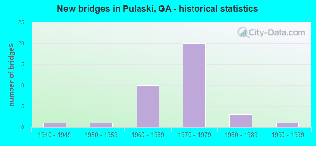
- New bridges - historical statistics
- 11940-1949
- 11950-1959
- 101960-1969
- 201970-1979
- 31980-1989
- 11990-1999

- Reconstructed bridges - Historical Statistics
- 31980-1989
- 21990-1999
- 02000-2009
- 12010-2019


- Bridge Condition - Deck
- 96.0%Good
- 4.0%Satisfactory

- Bridge Condition - Superstructure
- 96.0%Good
- 4.0%Satisfactory

- Bridge Condition - Substructure
- 92.0%Good
- 8.0%Satisfactory

- Bridge Condition - Channel
- 52.2%Very good
- 34.8%Good
- 4.3%Satisfactory
- 8.7%Fair

- Bridge Condition - Culverts
- 81.8%Good
- 9.1%Satisfactory
- 9.1%Fair
Find on map >> Show street view
Structure Number: 15009, Location: 2.3 MI S OF HOLMESVILLE (Lat: 31.672489, Lng: -82.319100), Route carried "on" structure: County highway 153, Year Built: 1980, Status: Open, Structure Length: 3.05m (10.01ft), Average Daily Traffic: 70 (year 2011), Truck Traffic: 1%, Average Future Daily Traffic: 105 (year 2031), Design Load: H 15, Features Intersected: SWEETWATER CREEK, Facility Carried by Structure: MILES-BECKWORTH RD
Minimum Vertical Clearance: 30+ m (98+ ft), Kilometerpoint: 1.609, Lanes on structure: 2, Base Highway Network: Yes, Owner: County Highway Agency, Approaching Roadway Width: 7.3m (24.0ft), Material/Design: Prestressed concrete, Design/Construction: Channel Beam, Number Of Spans In Main Unit: 5, Length of Maximum Span: 6.1m (20.0ft), Curb-To-Curb Width: 8.7m (28.5ft), Out-to-Out Width: 9.6m (31.5ft)
Condition: Deck: Good, Superstructure: Good, Substructure: Good, Channel: Very good, Operating Rating: 37.1 metric tons, Method Used To Determine Operating Rating: Load Factor (LF), Inventory Rating: 25.4 metric tons, Method Used To Determine Inventory Rating: Load Factor (LF), Structural Evaluation: Equal to present minimum criteria, Deck Geometry: Better than present minimum criteria, Waterway Adequacy: Equal to present desirable criteria, Approach Roadway Alignment: Equal to present desirable criteria, Designated Inspection Frequency: Every 24 months, Inspection Date: January 2021, Bridge Improvement Cost: $391,000, Roadway Improvement Cost: $39,000, Total Project Cost: $586,000, Deck Structure Type: Concrete Precast Panels
Find on map >> Show street view
Structure Number: 15017, Location: 5.7 MI S OF SURRENCY (Lat: 31.645719, Lng: -82.223419), Route carried "on" structure: County highway 208, Year Built: 1965, Status: Open, Structure Length: 0.88m (2.89ft), Average Daily Traffic: 160 (year 2011), Truck Traffic: 1%, Average Future Daily Traffic: 240 (year 2031), Design Load: H 15, Features Intersected: DRY BRANCH, Facility Carried by Structure: HOLMESVILLE ROAD
Minimum Vertical Clearance: 30+ m (98+ ft), Kilometerpoint: 1.609, Lanes on structure: 2, Base Highway Network: Yes, Owner: County Highway Agency, Approaching Roadway Width: 5.8m (19.0ft), Material/Design: Concrete, Design/Construction: Culvert, Number Of Spans In Main Unit: 3, Length of Maximum Span: 2.7m (8.9ft)
Condition: Channel: Good, Culverts: Good, Operating Rating: 41.7 metric tons, Method Used To Determine Operating Rating: Field evaluation and documented engineering judgment, Inventory Rating: 24.4 metric tons, Method Used To Determine Inventory Rating: Field evaluation and documented engineering judgment, Structural Evaluation: Equal to present minimum criteria, Waterway Adequacy: Equal to present desirable criteria, Approach Roadway Alignment: Equal to present desirable criteria, Designated Inspection Frequency: Every 24 months, Inspection Date: January 2021, Bridge Improvement Cost: $113,000, Roadway Improvement Cost: $11,000, Total Project Cost: $170,000
Find on map >> Show street view
Structure Number: 15024, Location: 4.3 MI N OF BAXLEY (Lat: 31.830978, Lng: -82.327489), Route carried "on" structure: County highway 591, Year Built: 1977, Year Reconstructed: 2003, Status: Open, Structure Length: 3.66m (12.01ft), Average Daily Traffic: 690 (year 2011), Truck Traffic: 1%, Average Future Daily Traffic: 1,035 (year 2031), Design Load: H 15, Features Intersected: TEN MILE CREEK, Facility Carried by Structure: BEN CARTER ROAD
Minimum Vertical Clearance: 30+ m (98+ ft), Kilometerpoint: 4.828, Lanes on structure: 2, Base Highway Network: Yes, Owner: County Highway Agency, Approaching Roadway Width: 5.8m (19.0ft), Material/Design: Prestressed concrete, Design/Construction: Channel Beam, Number Of Spans In Main Unit: 6, Length of Maximum Span: 6.1m (20.0ft), Curb-To-Curb Width: 6.9m (22.6ft), Out-to-Out Width: 7.7m (25.3ft)
Condition: Deck: Good, Superstructure: Good, Substructure: Good, Channel: Good, Operating Rating: 46.2 metric tons, Method Used To Determine Operating Rating: Load Factor (LF), Inventory Rating: 26.3 metric tons, Method Used To Determine Inventory Rating: Load Factor (LF), Structural Evaluation: Equal to present minimum criteria, Deck Geometry: Meets minimum limits, Waterway Adequacy: Better than present minimum criteria, Approach Roadway Alignment: Equal to present desirable criteria, Designated Inspection Frequency: Every 24 months, Underwater Inspection Frequency: Every 60 months, Inspection Date: January 2021, Underwater Inspection Date: June 2020, Bridge Improvement Cost: $469,000, Roadway Improvement Cost: $47,000, Total Project Cost: $703,000, Deck Structure Type: Concrete Precast Panels
Find on map >> Show street view
Structure Number: 15028, Location: 7 MI SW OF BAXLEY (Lat: 31.694519, Lng: -82.445969), Route carried "on" structure: County highway 535, Year Built: 1975, Year Reconstructed: 2003, Status: Open, Structure Length: 5.49m (18.01ft), Average Daily Traffic: 190 (year 2011), Truck Traffic: 1%, Average Future Daily Traffic: 285 (year 2031), Design Load: H 15, Features Intersected: BISHOP CREEK, Facility Carried by Structure: DYAL SCHOOL ROAD
Minimum Vertical Clearance: 30+ m (98+ ft), Kilometerpoint: 4.828, Lanes on structure: 2, Base Highway Network: Yes, Owner: County Highway Agency, Approaching Roadway Width: 5.5m (18.0ft), Material/Design: Prestressed concrete, Design/Construction: Channel Beam, Number Of Spans In Main Unit: 9, Length of Maximum Span: 6.1m (20.0ft), Curb-To-Curb Width: 7.1m (23.3ft), Out-to-Out Width: 7.7m (25.3ft)
Condition: Deck: Good, Superstructure: Good, Substructure: Good, Channel: Good, Operating Rating: 36.2 metric tons, Method Used To Determine Operating Rating: Load Factor (LF), Inventory Rating: 22.6 metric tons, Method Used To Determine Inventory Rating: Load Factor (LF), Structural Evaluation: Equal to present minimum criteria, Deck Geometry: Meets minimum limits, Waterway Adequacy: Equal to present desirable criteria, Approach Roadway Alignment: Equal to present desirable criteria, Designated Inspection Frequency: Every 24 months, Underwater Inspection Frequency: Every 60 months, Inspection Date: January 2021, Underwater Inspection Date: June 2020, Bridge Improvement Cost: $703,000, Roadway Improvement Cost: $70,000, Total Project Cost: $1,055,000, Deck Structure Type: Concrete Precast Panels
Find on map >> Show street view
Structure Number: 150024, Location: 2.6 MI SW OF KINGSTON (Lat: 34.208847, Lng: -84.978569), Route carried "on" structure: US 411, Year Built: 1959, Year Reconstructed: 2017, Status: Open, Structure Length: 10.88m (35.70ft), Average Daily Traffic: 15,890 (year 2015), Truck Traffic: 1%, Average Future Daily Traffic: 23,835 (year 2035), Design Load: HS 20+Mod, Features Intersected: ETOWAH RIVER
Minimum Vertical Clearance: 30+ m (98+ ft), Kilometerpoint: 6.437, Lanes on structure: 2, Base Highway Network: Yes, Owner: State Highway Agency, Approaching Roadway Width: 8.8m (28.9ft), Skew: 10 degrees, Material/Design: Steel continuous, Design/Construction: Stringer/Multi-beam, Number Of Spans In Main Unit: 5, Length of Maximum Span: 30.5m (100.1ft), Curb or Sidewalk Widths: Left: 0.7m (2.3ft), Right: 0.7m (2.3ft), Curb-To-Curb Width: 9.1m (29.9ft), Out-to-Out Width: 10.1m (33.1ft)
Condition: Deck: Good, Superstructure: Good, Substructure: Satisfactory, Channel: Very good, Operating Rating: 30.8 metric tons, Method Used To Determine Operating Rating: Load Factor (LF), Inventory Rating: 18.1 metric tons, Method Used To Determine Inventory Rating: Load Factor (LF), Structural Evaluation: Meets minimum limits, Deck Geometry: Meets minimum limits, Waterway Adequacy: Superior to present desirable criteria, Approach Roadway Alignment: Equal to present desirable criteria, Designated Inspection Frequency: Every 24 months, Underwater Inspection Frequency: Every 60 months, Inspection Date: July 2020, Underwater Inspection Date: May 2019, Bridge Improvement Cost: $1,395,000, Roadway Improvement Cost: $139,000, Total Project Cost: $2,092,000, Deck Structure Type: Concrete Cast-file-Place, Wearing Surface/Protective System: Wearing Surface: Epoxy Overlay
Find on map >> Show street view
Structure Number: 150047, Location: 2.3 MI E OF CARTERSVILLE (Lat: 34.174647, Lng: -84.759158), Route carried "on" structure: State highway 113, Year Built: 1977, Status: Open, Structure Length: 8.99m (29.49ft), Average Daily Traffic: 14,920 (year 2011), Truck Traffic: 12%, Average Future Daily Traffic: 22,380 (year 2031), Design Load: HS 20+Mod, Features Intersected: I-75
Minimum Vertical Clearance: 30+ m (98+ ft), Kilometerpoint: 24.140, Lanes on structure: 2, Lanes under structure: 7, Base Highway Network: Yes, Owner: State Highway Agency, Approaching Roadway Width: 11.0m (36.1ft), Skew: 11 degrees, Material/Design: Steel continuous, Design/Construction: Stringer/Multi-beam, Number Of Spans In Main Unit: 2, Length of Maximum Span: 48.8m (160.1ft), Curb-To-Curb Width: 12.8m (42.0ft), Out-to-Out Width: 13.6m (44.6ft)
Condition: Deck: Good, Superstructure: Good, Substructure: Good, Operating Rating: 54.4 metric tons, Method Used To Determine Operating Rating: Load Factor (LF), Inventory Rating: 32.6 metric tons, Method Used To Determine Inventory Rating: Load Factor (LF), Structural Evaluation: Better than present minimum criteria, Deck Geometry: Equal to present desirable criteria, Underclear: Better than present minimum criteria, Approach Roadway Alignment: Equal to present desirable criteria, Designated Inspection Frequency: Every 24 months, Inspection Date: August 2020, Bridge Improvement Cost: $1,153,000, Roadway Improvement Cost: $115,000, Total Project Cost: $1,729,000, Deck Structure Type: Concrete Cast-file-Place, Wearing Surface/Protective System: Wearing Surface: Epoxy Overlay
Find on map >> Show street view
Structure Number: 150052, Location: 0.6 MI E OF FOLSOM (Lat: 34.380369, Lng: -84.818928), Route carried "on" structure: State highway 140, Year Built: 1973, Year Reconstructed: 1992, Status: Open, Structure Length: 0.79m (2.59ft), Average Daily Traffic: 4,350 (year 2011), Truck Traffic: 1%, Average Future Daily Traffic: 6,525 (year 2031), Design Load: HS 20+Mod, Features Intersected: BALLARD CREEK
Minimum Vertical Clearance: 30+ m (98+ ft), Kilometerpoint: 17.703, Lanes on structure: 2, Base Highway Network: Yes, Owner: State Highway Agency, Approaching Roadway Width: 8.5m (27.9ft), Material/Design: Concrete, Design/Construction: Culvert, Number Of Spans In Main Unit: 3, Length of Maximum Span: 2.4m (7.9ft)
Condition: Channel: Good, Culverts: Satisfactory, Operating Rating: 78.0 metric tons, Method Used To Determine Operating Rating: Load Factor (LF), Inventory Rating: 46.2 metric tons, Method Used To Determine Inventory Rating: Load Factor (LF), Structural Evaluation: Equal to present minimum criteria, Waterway Adequacy: Superior to present desirable criteria, Approach Roadway Alignment: Equal to present desirable criteria, Designated Inspection Frequency: Every 24 months, Inspection Date: September 2020, Bridge Improvement Cost: $102,000, Roadway Improvement Cost: $10,000, Total Project Cost: $152,000
Find on map >> Show street view
Structure Number: 150072, Location: 4.1 MI SE OF EMERSON (Lat: 34.088478, Lng: -84.700608), Route carried "on" structure: County highway 369, Year Built: 1977, Status: Open, Structure Length: 10.70m (35.10ft), Average Daily Traffic: 620 (year 2011), Truck Traffic: 1%, Average Future Daily Traffic: 930 (year 2031), Design Load: HS 15, Features Intersected: I-75, Facility Carried by Structure: ALLTOONA SHORES RD
Minimum Vertical Clearance: 30+ m (98+ ft), Kilometerpoint: 0.000, Lanes on structure: 2, Lanes under structure: 6, Base Highway Network: Yes, Owner: State Highway Agency, Approaching Roadway Width: 6.7m (22.0ft), Skew: 3 degrees, Material/Design: Steel continuous, Design/Construction: Stringer/Multi-beam, Number Of Spans In Main Unit: 4, Length of Maximum Span: 35.4m (116.1ft), Curb-To-Curb Width: 9.8m (32.2ft), Out-to-Out Width: 10.7m (35.1ft)
Condition: Deck: Good, Superstructure: Good, Substructure: Good, Operating Rating: 43.5 metric tons, Method Used To Determine Operating Rating: Load Factor (LF), Inventory Rating: 26.3 metric tons, Method Used To Determine Inventory Rating: Load Factor (LF), Structural Evaluation: Equal to present minimum criteria, Deck Geometry: Equal to present minimum criteria, Underclear: Better than present minimum criteria, Approach Roadway Alignment: Equal to present desirable criteria, Designated Inspection Frequency: Every 24 months, Inspection Date: October 2020, Bridge Improvement Cost: $1,371,000, Roadway Improvement Cost: $137,000, Total Project Cost: $2,057,000, Deck Structure Type: Concrete Cast-file-Place
Find on map >> Show street view
Structure Number: 150075, Location: 5.5 MI SE OF EMERSON (Lat: 34.080669, Lng: -84.676469), Route carried "on" structure: Interstate 75, Year Built: 1977, Status: Open, Structure Length: 5.94m (19.49ft), Average Daily Traffic: 88,590 (year 2011), Truck Traffic: 1%, Average Future Daily Traffic: 132,885 (year 2031), Design Load: HS 20+Mod, Features Intersected: M-9464 GLADE ROAD
Minimum Vertical Clearance: 30+ m (98+ ft), Kilometerpoint: 449.007, Lanes on structure: 3, Lanes under structure: 4, Base Highway Network: Yes, Owner: State Highway Agency, Approaching Roadway Width: 17.1m (56.1ft), Skew: 11 degrees, Material/Design: Steel, Design/Construction: Stringer/Multi-beam, Number Of Spans In Main Unit: 4, Length of Maximum Span: 16.5m (54.1ft), Curb-To-Curb Width: 18.3m (60.0ft), Out-to-Out Width: 19.0m (62.3ft)
Condition: Deck: Good, Superstructure: Good, Substructure: Good, Operating Rating: 48.0 metric tons, Method Used To Determine Operating Rating: Load Factor (LF), Inventory Rating: 29.0 metric tons, Method Used To Determine Inventory Rating: Load Factor (LF), Structural Evaluation: Better than present minimum criteria, Deck Geometry: Better than present minimum criteria, Underclear: Meets minimum limits, Approach Roadway Alignment: Equal to present desirable criteria, Designated Inspection Frequency: Every 24 months, Inspection Date: August 2020, Bridge Improvement Cost: $970,000, Roadway Improvement Cost: $97,000, Total Project Cost: $1,455,000, Deck Structure Type: Concrete Cast-file-Place, Wearing Surface/Protective System: Wearing Surface: Epoxy Overlay
Find on map >> Show street view
Structure Number: 150088, Location: 2.4 MI E OF CARTERSVILLE (Lat: 34.162997, Lng: -84.756539), Route carried "on" structure: Interstate 75, Year Built: 1977, Status: Open, Structure Length: 7.68m (25.20ft), Average Daily Traffic: 84,630 (year 2011), Truck Traffic: 1%, Average Future Daily Traffic: 126,945 (year 2031), Design Load: HS 20+Mod, Features Intersected: CR 360 OLD RIVER ROAD
Minimum Vertical Clearance: 30+ m (98+ ft), Kilometerpoint: 461.882, Lanes on structure: 3, Lanes under structure: 2, Base Highway Network: Yes, Owner: State Highway Agency, Approaching Roadway Width: 17.1m (56.1ft), Skew: 13 degrees, Material/Design: Steel, Design/Construction: Stringer/Multi-beam, Number Of Spans In Main Unit: 3, Length of Maximum Span: 25.6m (84.0ft), Curb-To-Curb Width: 18.1m (59.4ft), Out-to-Out Width: 19.0m (62.3ft)
Condition: Deck: Good, Superstructure: Good, Substructure: Good, Operating Rating: 38.1 metric tons, Method Used To Determine Operating Rating: Load Factor (LF), Inventory Rating: 22.6 metric tons, Method Used To Determine Inventory Rating: Load Factor (LF), Structural Evaluation: Somewhat better than minimum adequacy, Deck Geometry: Better than present minimum criteria, Underclear: Equal to present minimum criteria, Approach Roadway Alignment: Equal to present desirable criteria, Designated Inspection Frequency: Every 24 months, Inspection Date: August 2020, Bridge Improvement Cost: $1,253,000, Roadway Improvement Cost: $125,000, Total Project Cost: $1,880,000, Deck Structure Type: Concrete Cast-file-Place, Wearing Surface/Protective System: Wearing Surface: Epoxy Overlay
Find on map >> Show street view
Structure Number: 150089, Location: 2.4 MI NE OF CARTERSVILLE (Lat: 34.190308, Lng: -84.766689), Route carried "on" structure: Interstate 75, Year Built: 1977, Status: Open, Structure Length: 6.31m (20.70ft), Average Daily Traffic: 77,870 (year 2011), Truck Traffic: 1%, Average Future Daily Traffic: 116,805 (year 2031), Design Load: HS 20+Mod, Features Intersected: M-920 CENTER ROAD
Minimum Vertical Clearance: 30+ m (98+ ft), Kilometerpoint: 465.101, Lanes on structure: 4, Lanes under structure: 2, Base Highway Network: Yes, Owner: State Highway Agency, Approaching Roadway Width: 20.7m (67.9ft), Skew: 19 degrees, Material/Design: Steel, Design/Construction: Stringer/Multi-beam, Number Of Spans In Main Unit: 3, Length of Maximum Span: 26.8m (87.9ft), Curb-To-Curb Width: 21.9m (71.9ft), Out-to-Out Width: 22.7m (74.5ft)
Condition: Deck: Good, Superstructure: Good, Substructure: Good, Operating Rating: 53.5 metric tons, Method Used To Determine Operating Rating: Load Factor (LF), Inventory Rating: 31.7 metric tons, Method Used To Determine Inventory Rating: Load Factor (LF), Structural Evaluation: Better than present minimum criteria, Deck Geometry: Better than present minimum criteria, Underclear: Superior to present desirable criteria, Approach Roadway Alignment: Equal to present desirable criteria, Designated Inspection Frequency: Every 24 months, Inspection Date: October 2020, Bridge Improvement Cost: $1,250,000, Roadway Improvement Cost: $125,000, Total Project Cost: $1,875,000, Deck Structure Type: Concrete Cast-file-Place, Wearing Surface/Protective System: Wearing Surface: Epoxy Overlay
Find on map >> Show street view
Structure Number: 150091, Location: 3.3 MI NE OF CARTERSVILLE (Lat: 34.206658, Lng: -84.761389), Route carried "on" structure: Interstate 75, Year Built: 1977, Status: Open, Structure Length: 11.37m (37.30ft), Average Daily Traffic: 77,870 (year 2011), Truck Traffic: 1%, Average Future Daily Traffic: 116,805 (year 2031), Design Load: HS 20+Mod, Features Intersected: SR 20
Minimum Vertical Clearance: 30+ m (98+ ft), Kilometerpoint: 466.710, Lanes on structure: 3, Lanes under structure: 4, Base Highway Network: Yes, Owner: State Highway Agency, Approaching Roadway Width: 17.1m (56.1ft), Skew: 14 degrees, Material/Design: Steel, Design/Construction: Stringer/Multi-beam, Number Of Spans In Main Unit: 4, Length of Maximum Span: 36.9m (121.1ft), Curb-To-Curb Width: 18.3m (60.0ft), Out-to-Out Width: 19.0m (62.3ft)
Condition: Deck: Good, Superstructure: Good, Substructure: Good, Operating Rating: 32.6 metric tons, Method Used To Determine Operating Rating: Load Factor (LF), Inventory Rating: 19.0 metric tons, Method Used To Determine Inventory Rating: Load Factor (LF), Structural Evaluation: Meets minimum limits, Deck Geometry: Better than present minimum criteria, Underclear: Superior to present desirable criteria, Approach Roadway Alignment: Equal to present desirable criteria, Designated Inspection Frequency: Every 24 months, Inspection Date: October 2020, Bridge Improvement Cost: $1,855,000, Roadway Improvement Cost: $185,000, Total Project Cost: $2,782,000, Deck Structure Type: Concrete Cast-file-Place, Wearing Surface/Protective System: Wearing Surface: Epoxy Overlay
Find on map >> Show street view
Structure Number: 150092, Location: 3.3 MI NE OF CARTERSVILLE (Lat: 34.206389, Lng: -84.761728), Route carried "on" structure: Interstate 75, Year Built: 1977, Status: Open, Structure Length: 11.46m (37.60ft), Average Daily Traffic: 65,710 (year 2011), Truck Traffic: 26%, Average Future Daily Traffic: 98,565 (year 2031), Design Load: HS 20+Mod, Features Intersected: SR 20
Minimum Vertical Clearance: 30+ m (98+ ft), Kilometerpoint: 466.710, Lanes on structure: 3, Lanes under structure: 4, Base Highway Network: Yes, Owner: State Highway Agency, Approaching Roadway Width: 17.1m (56.1ft), Skew: 14 degrees, Material/Design: Steel, Design/Construction: Stringer/Multi-beam, Number Of Spans In Main Unit: 4, Length of Maximum Span: 33.5m (109.9ft), Curb-To-Curb Width: 18.3m (60.0ft), Out-to-Out Width: 19.0m (62.3ft)
Condition: Deck: Good, Superstructure: Good, Substructure: Good, Operating Rating: 39.9 metric tons, Method Used To Determine Operating Rating: Load Factor (LF), Inventory Rating: 23.5 metric tons, Method Used To Determine Inventory Rating: Load Factor (LF), Structural Evaluation: Somewhat better than minimum adequacy, Deck Geometry: Better than present minimum criteria, Underclear: Equal to present desirable criteria, Approach Roadway Alignment: Equal to present desirable criteria, Designated Inspection Frequency: Every 24 months, Inspection Date: October 2020, Bridge Improvement Cost: $1,870,000, Roadway Improvement Cost: $187,000, Total Project Cost: $2,805,000, Deck Structure Type: Concrete Cast-file-Place, Wearing Surface/Protective System: Wearing Surface: Epoxy Overlay
Find on map >> Show street view
Structure Number: 150097, Location: 2.9 MI S OF WHITE (Lat: 34.248458, Lng: -84.780828), Route carried "on" structure: Interstate 75, Year Built: 1969, Status: Open, Structure Length: 1.58m (5.18ft), Average Daily Traffic: 64,580 (year 2011), Truck Traffic: 1%, Average Future Daily Traffic: 96,870 (year 2031), Design Load: HS 20+Mod, Features Intersected: PETTIT CREEK
Minimum Vertical Clearance: 30+ m (98+ ft), Kilometerpoint: 473.147, Lanes on structure: 6, Base Highway Network: Yes, Owner: State Highway Agency, Approaching Roadway Width: 32.3m (106.0ft), Skew: 13 degrees, Material/Design: Concrete, Design/Construction: Culvert, Number Of Spans In Main Unit: 4, Length of Maximum Span: 3.7m (12.1ft)
Condition: Channel: Very good, Culverts: Good, Structural Evaluation: Better than present minimum criteria, Waterway Adequacy: Superior to present desirable criteria, Approach Roadway Alignment: Equal to present desirable criteria, Designated Inspection Frequency: Every 24 months, Inspection Date: August 2020, Bridge Improvement Cost: $425,000, Roadway Improvement Cost: $42,000, Total Project Cost: $637,000
Find on map >> Show street view
Structure Number: 150098, Location: 3 MI SW OF WHITE (Lat: 34.255519, Lng: -84.791519), Route carried "on" structure: Interstate 75, Year Built: 1969, Status: Open, Structure Length: 1.28m (4.20ft), Average Daily Traffic: 64,580 (year 2011), Truck Traffic: 1%, Average Future Daily Traffic: 96,870 (year 2031), Design Load: HS 20+Mod, Features Intersected: PETTIT CREEK TRIB
Minimum Vertical Clearance: 30+ m (98+ ft), Kilometerpoint: 474.757, Lanes on structure: 6, Base Highway Network: Yes, Owner: State Highway Agency, Approaching Roadway Width: 34.1m (111.9ft), Skew: 10 degrees, Material/Design: Concrete, Design/Construction: Culvert, Number Of Spans In Main Unit: 6, Length of Maximum Span: 1.8m (5.9ft)
Condition: Channel: Very good, Culverts: Good, Operating Rating: 55.3 metric tons, Method Used To Determine Operating Rating: Load Factor (LF), Inventory Rating: 32.6 metric tons, Method Used To Determine Inventory Rating: Load Factor (LF), Structural Evaluation: Better than present minimum criteria, Waterway Adequacy: Superior to present desirable criteria, Approach Roadway Alignment: Equal to present desirable criteria, Designated Inspection Frequency: Every 24 months, Inspection Date: August 2020, Bridge Improvement Cost: $343,000, Roadway Improvement Cost: $34,000, Total Project Cost: $515,000
Find on map >> Show street view
Structure Number: 150099, Location: 3.1 MI SW OF WHITE (Lat: 34.257719, Lng: -84.795850), Route carried "on" structure: Interstate 75, Year Built: 1969, Status: Open, Structure Length: 2.01m (6.59ft), Average Daily Traffic: 64,580 (year 2011), Truck Traffic: 1%, Average Future Daily Traffic: 96,870 (year 2031), Design Load: HS 20+Mod, Features Intersected: PETTIT CREEK TRIB
Minimum Vertical Clearance: 30+ m (98+ ft), Kilometerpoint: 474.757, Lanes on structure: 6, Base Highway Network: Yes, Owner: State Highway Agency, Approaching Roadway Width: 34.1m (111.9ft), Skew: 14 degrees, Material/Design: Concrete, Design/Construction: Culvert, Number Of Spans In Main Unit: 6, Length of Maximum Span: 3.0m (9.8ft)
Condition: Channel: Very good, Culverts: Good, Operating Rating: 55.3 metric tons, Method Used To Determine Operating Rating: Load Factor (LF), Inventory Rating: 32.6 metric tons, Method Used To Determine Inventory Rating: Load Factor (LF), Structural Evaluation: Better than present minimum criteria, Waterway Adequacy: Superior to present desirable criteria, Approach Roadway Alignment: Equal to present desirable criteria, Designated Inspection Frequency: Every 24 months, Inspection Date: August 2020, Bridge Improvement Cost: $539,000, Roadway Improvement Cost: $54,000, Total Project Cost: $809,000
Find on map >> Show street view
Structure Number: 1501, Location: 4 MI W OF WHITE (Lat: 34.286339, Lng: -84.820497), Route carried "on" structure: Interstate 75, Year Built: 1969, Status: Open, Structure Length: 1.52m (4.99ft), Average Daily Traffic: 58,570 (year 2011), Truck Traffic: 1%, Average Future Daily Traffic: 87,855 (year 2031), Design Load: HS 20+Mod, Features Intersected: TWO RUN CREEK
Minimum Vertical Clearance: 30+ m (98+ ft), Kilometerpoint: 479.585, Lanes on structure: 6, Base Highway Network: Yes, Owner: State Highway Agency, Approaching Roadway Width: 34.1m (111.9ft), Skew: 13 degrees, Material/Design: Concrete, Design/Construction: Culvert, Number Of Spans In Main Unit: 4, Length of Maximum Span: 3.7m (12.1ft)
Condition: Channel: Satisfactory, Culverts: Good, Operating Rating: 55.3 metric tons, Method Used To Determine Operating Rating: Load Factor (LF), Inventory Rating: 32.6 metric tons, Method Used To Determine Inventory Rating: Load Factor (LF), Structural Evaluation: Better than present minimum criteria, Waterway Adequacy: Superior to present desirable criteria, Approach Roadway Alignment: Equal to present desirable criteria, Designated Inspection Frequency: Every 24 months, Inspection Date: September 2020, Bridge Improvement Cost: $408,000, Roadway Improvement Cost: $41,000, Total Project Cost: $613,000
Find on map >> Show street view
Structure Number: 150101, Location: 5.2 MI NW OF WHITE (Lat: 34.308950, Lng: -84.836406), Route carried "on" structure: Interstate 75, Year Built: 1970, Year Reconstructed: 1987, Status: Open, Structure Length: 5.82m (19.09ft), Average Daily Traffic: 58,570 (year 2011), Truck Traffic: 1%, Average Future Daily Traffic: 87,855 (year 2031), Design Load: HS 20+Mod, Features Intersected: CR 179 CEDAR CREEK ROAD
Minimum Vertical Clearance: 30+ m (98+ ft), Kilometerpoint: 482.803, Lanes on structure: 6, Lanes under structure: 2, Base Highway Network: Yes, Owner: State Highway Agency, Approaching Roadway Width: 34.1m (111.9ft), Skew: 34 degrees, Material/Design: Steel continuous, Design/Construction: Stringer/Multi-beam, Number Of Spans In Main Unit: 3, Length of Maximum Span: 27.1m (88.9ft), Curb-To-Curb Width: 39.5m (129.6ft), Out-to-Out Width: 41.1m (134.8ft)
Condition: Deck: Good, Superstructure: Good, Substructure: Good, Operating Rating: 24.4 metric tons, Method Used To Determine Operating Rating: Load Factor (LF), Inventory Rating: 14.5 metric tons, Method Used To Determine Inventory Rating: Load Factor (LF), Structural Evaluation: High priority of corrective action, Deck Geometry: Superior to present desirable criteria, Underclear: Somewhat better than minimum adequacy, Approach Roadway Alignment: Equal to present desirable criteria, Designated Inspection Frequency: Every 24 months, Inspection Date: August 2020, Bridge Improvement Cost: $1,560,000, Roadway Improvement Cost: $156,000, Total Project Cost: $2,341,000, Deck Structure Type: Concrete Cast-file-Place, Wearing Surface/Protective System: Wearing Surface: Epoxy Overlay
Find on map >> Show street view
Structure Number: 150103, Location: 2.7 MI E OF ADAIRSVILLE (Lat: 34.358478, Lng: -84.889758), Route carried "on" structure: Interstate 75, Year Built: 1970, Year Reconstructed: 1987, Status: Open, Structure Length: 5.03m (16.50ft), Average Daily Traffic: 58,100 (year 2011), Truck Traffic: 1%, Average Future Daily Traffic: 87,150 (year 2031), Design Load: HS 20+Mod, Features Intersected: CR 452 ADAIRSVL-PLEASANT
Minimum Vertical Clearance: 30+ m (98+ ft), Kilometerpoint: 489.241, Lanes on structure: 3, Lanes under structure: 2, Base Highway Network: Yes, Owner: State Highway Agency, Approaching Roadway Width: 17.1m (56.1ft), Skew: 13 degrees, Material/Design: Steel continuous, Design/Construction: Stringer/Multi-beam, Number Of Spans In Main Unit: 3, Length of Maximum Span: 23.5m (77.1ft), Curb-To-Curb Width: 17.7m (58.1ft), Out-to-Out Width: 18.5m (60.7ft)
Condition: Deck: Good, Superstructure: Good, Substructure: Good, Operating Rating: 44.4 metric tons, Method Used To Determine Operating Rating: Load Factor (LF), Inventory Rating: 26.3 metric tons, Method Used To Determine Inventory Rating: Load Factor (LF), Structural Evaluation: Equal to present minimum criteria, Deck Geometry: Better than present minimum criteria, Underclear: Superior to present desirable criteria, Approach Roadway Alignment: Equal to present desirable criteria, Designated Inspection Frequency: Every 24 months, Inspection Date: October 2020, Bridge Improvement Cost: $821,000, Roadway Improvement Cost: $82,000, Total Project Cost: $1,231,000, Deck Structure Type: Concrete Cast-file-Place, Wearing Surface/Protective System: Wearing Surface: Epoxy Overlay
Find on map >> Show street view
Structure Number: 150108, Location: 3.7 MI S OF CARTERSVILLE (Lat: 34.115200, Lng: -84.790308), Route carried "on" structure: County highway 2946, Year Built: 1979, Status: Open, Structure Length: 15.54m (50.98ft), Average Daily Traffic: 7,080 (year 2011), Truck Traffic: 1%, Average Future Daily Traffic: 10,620 (year 2031), Design Load: HS 20+Mod, Features Intersected: PUMPKINVINE CREEK, Facility Carried by Structure: OLD ALABAMA ROAD
Minimum Vertical Clearance: 30+ m (98+ ft), Kilometerpoint: 8.047, Lanes on structure: 2, Base Highway Network: Yes, Owner: County Highway Agency, Approaching Roadway Width: 7.3m (24.0ft), Skew: 3 degrees, Material/Design: Prestressed concrete, Design/Construction: Stringer/Multi-beam, Number Of Spans In Main Unit: 1, Number Of Approach Spans: 11, Length of Maximum Span: 21.3m (69.9ft), Curb-To-Curb Width: 12.2m (40.0ft), Out-to-Out Width: 13.2m (43.3ft)
Condition: Deck: Good, Superstructure: Satisfactory, Substructure: Good, Channel: Fair, Operating Rating: 43.5 metric tons, Method Used To Determine Operating Rating: Load Factor (LF), Inventory Rating: 25.4 metric tons, Method Used To Determine Inventory Rating: Load Factor (LF), Structural Evaluation: Equal to present minimum criteria, Deck Geometry: Somewhat better than minimum adequacy, Waterway Adequacy: Equal to present minimum criteria, Approach Roadway Alignment: Equal to present desirable criteria, Designated Inspection Frequency: Every 24 months, Inspection Date: August 2020, Bridge Improvement Cost: $1,993,000, Roadway Improvement Cost: $199,000, Total Project Cost: $2,989,000, Deck Structure Type: Concrete Cast-file-Place
Find on map >> Show street view
Structure Number: 150121, Location: 3.7 MI N OF CARTERSVILLE (Lat: 34.221269, Lng: -84.802508), Route carried "on" structure: City street 919, Year Built: 1978, Status: Open, Structure Length: 3.87m (12.70ft), Average Daily Traffic: 4,610 (year 2011), Truck Traffic: 1%, Average Future Daily Traffic: 6,915 (year 2031), Design Load: HS 20+Mod, Features Intersected: PETTIT CREEK, Facility Carried by Structure: PEEPLES VALLEY RD.
Minimum Vertical Clearance: 30+ m (98+ ft), Kilometerpoint: 1.609, Lanes on structure: 2, Base Highway Network: Yes, Owner: County Highway Agency, Approaching Roadway Width: 7.3m (24.0ft), Material/Design: Steel, Design/Construction: Stringer/Multi-beam, Number Of Spans In Main Unit: 2, Length of Maximum Span: 19.5m (64.0ft), Curb-To-Curb Width: 13.0m (42.7ft), Out-to-Out Width: 13.9m (45.6ft)
Condition: Deck: Good, Superstructure: Good, Substructure: Good, Channel: Very good, Operating Rating: 57.1 metric tons, Method Used To Determine Operating Rating: Load Factor (LF), Inventory Rating: 34.4 metric tons, Method Used To Determine Inventory Rating: Load Factor (LF), Structural Evaluation: Better than present minimum criteria, Deck Geometry: Equal to present minimum criteria, Waterway Adequacy: Equal to present desirable criteria, Approach Roadway Alignment: Equal to present desirable criteria, Designated Inspection Frequency: Every 24 months, Inspection Date: July 2020, Bridge Improvement Cost: $496,000, Roadway Improvement Cost: $50,000, Total Project Cost: $744,000, Deck Structure Type: Concrete Cast-file-Place
Find on map >> Show street view
Structure Number: 150124, Location: 1.5 MI NE OF EMERSON (Lat: 34.142589, Lng: -84.738939), Route carried "on" structure: County highway 1665, Year Built: 1977, Status: Open, Structure Length: 8.47m (27.79ft), Average Daily Traffic: 4,100 (year 2011), Truck Traffic: 1%, Average Future Daily Traffic: 6,150 (year 2031), Design Load: HS 20+Mod, Features Intersected: I-75, Facility Carried by Structure: RED TOP MTN. ROAD
Minimum Vertical Clearance: 30+ m (98+ ft), Kilometerpoint: 9.656, Lanes on structure: 4, Lanes under structure: 6, Base Highway Network: Yes, Owner: State Highway Agency, Approaching Roadway Width: 21.9m (71.9ft), Skew: 10 degrees, Material/Design: Steel continuous, Design/Construction: Stringer/Multi-beam, Number Of Spans In Main Unit: 2, Length of Maximum Span: 42.4m (139.1ft), Curb-To-Curb Width: 23.2m (76.1ft), Out-to-Out Width: 28.8m (94.5ft)
Condition: Deck: Good, Superstructure: Good, Substructure: Good, Operating Rating: 44.4 metric tons, Method Used To Determine Operating Rating: Load Factor (LF), Inventory Rating: 26.3 metric tons, Method Used To Determine Inventory Rating: Load Factor (LF), Structural Evaluation: Equal to present minimum criteria, Deck Geometry: Superior to present desirable criteria, Underclear: Better than present minimum criteria, Approach Roadway Alignment: Equal to present desirable criteria, Designated Inspection Frequency: Every 24 months, Inspection Date: August 2020, Bridge Improvement Cost: $1,679,000, Roadway Improvement Cost: $168,000, Total Project Cost: $2,518,000, Deck Structure Type: Concrete Cast-file-Place, Wearing Surface/Protective System: Wearing Surface: Epoxy Overlay
Find on map >> Show street view
Structure Number: 315003, Location: 8.3 MI W OF STATESBORO (Lat: 32.413897, Lng: -81.915719), Route carried "on" structure: County highway 142, Year Built: 1965, Status: Posted for load, Structure Length: 2.74m (8.99ft), Average Daily Traffic: 3,210 (year 2011), Truck Traffic: 1%, Average Future Daily Traffic: 4,815 (year 2031), Design Load: H 15, Features Intersected: LOTTS CREEK OVERFLOW, Facility Carried by Structure: PULASKI ROAD
Minimum Vertical Clearance: 30+ m (98+ ft), Kilometerpoint: 1.609, Lanes on structure: 2, Base Highway Network: Yes, Owner: County Highway Agency, Approaching Roadway Width: 7.3m (24.0ft), Material/Design: Concrete, Design/Construction: Tee Beam, Number Of Spans In Main Unit: 3, Length of Maximum Span: 9.1m (29.9ft), Curb or Sidewalk Widths: Left: 0.6m (2.0ft), Right: 0.6m (2.0ft), Curb-To-Curb Width: 7.3m (24.0ft), Out-to-Out Width: 9.2m (30.2ft)
Condition: Deck: Good, Superstructure: Good, Substructure: Good, Channel: Very good, Operating Rating: 30.8 metric tons, Method Used To Determine Operating Rating: Load Factor (LF), Inventory Rating: 18.1 metric tons, Method Used To Determine Inventory Rating: Load Factor (LF), Structural Evaluation: Somewhat better than minimum adequacy, Deck Geometry: High priority of replacement, Waterway Adequacy: Equal to present desirable criteria, Approach Roadway Alignment: Equal to present desirable criteria, Bridge Posting: Required (Relationship of Operating Rating to Maximum Legal Load: 0.1 - 9.9% below), Length Of Structure Improvement: 9.17m (30.09ft), Designated Inspection Frequency: Every 24 months, Inspection Date: April 2020, Bridge Improvement Cost: $352,000, Roadway Improvement Cost: $35,000, Total Project Cost: $527,000, Deck Structure Type: Concrete Cast-file-Place
Find on map >> Show street view
Structure Number: 315004, Location: 8.2 MI W OF STATESBORO (Lat: 32.415078, Lng: -81.913908), Route carried "on" structure: County highway 142, Year Built: 1965, Status: Posted for load, Structure Length: 5.49m (18.01ft), Average Daily Traffic: 3,210 (year 2011), Truck Traffic: 1%, Average Future Daily Traffic: 4,815 (year 2031), Design Load: H 15, Features Intersected: LOTTS CREEK, Facility Carried by Structure: PULASKI ROAD
Minimum Vertical Clearance: 30+ m (98+ ft), Kilometerpoint: 1.609, Lanes on structure: 2, Base Highway Network: Yes, Owner: County Highway Agency, Approaching Roadway Width: 7.3m (24.0ft), Material/Design: Concrete, Design/Construction: Tee Beam, Number Of Spans In Main Unit: 6, Length of Maximum Span: 9.1m (29.9ft), Curb or Sidewalk Widths: Left: 0.6m (2.0ft), Right: 0.6m (2.0ft), Curb-To-Curb Width: 7.3m (24.0ft), Out-to-Out Width: 9.2m (30.2ft)
Condition: Deck: Good, Superstructure: Good, Substructure: Good, Channel: Very good, Operating Rating: 30.8 metric tons, Method Used To Determine Operating Rating: Load Factor (LF), Inventory Rating: 18.1 metric tons, Method Used To Determine Inventory Rating: Load Factor (LF), Structural Evaluation: Somewhat better than minimum adequacy, Deck Geometry: High priority of replacement, Waterway Adequacy: Equal to present desirable criteria, Approach Roadway Alignment: Equal to present desirable criteria, Bridge Posting: Required (Relationship of Operating Rating to Maximum Legal Load: 0.1 - 9.9% below), Length Of Structure Improvement: 11.92m (39.11ft), Designated Inspection Frequency: Every 24 months, Inspection Date: April 2020, Bridge Improvement Cost: $703,000, Roadway Improvement Cost: $70,000, Total Project Cost: $1,055,000, Deck Structure Type: Concrete Cast-file-Place
Find on map >> Show street view
Structure Number: 315005, Location: 7 MI W OF STATESBORO (Lat: 32.415700, Lng: -81.912969), Route carried "on" structure: County highway 142, Year Built: 1965, Status: Posted for load, Structure Length: 2.74m (8.99ft), Average Daily Traffic: 3,210 (year 2011), Truck Traffic: 1%, Average Future Daily Traffic: 4,815 (year 2031), Design Load: H 15, Features Intersected: CROSSWAY BRANCH, Facility Carried by Structure: PULASKI ROAD
Minimum Vertical Clearance: 30+ m (98+ ft), Kilometerpoint: 1.609, Lanes on structure: 2, Base Highway Network: Yes, Owner: County Highway Agency, Approaching Roadway Width: 7.3m (24.0ft), Material/Design: Concrete, Design/Construction: Tee Beam, Number Of Spans In Main Unit: 3, Length of Maximum Span: 9.1m (29.9ft), Curb or Sidewalk Widths: Left: 0.6m (2.0ft), Right: 0.6m (2.0ft), Curb-To-Curb Width: 7.3m (24.0ft), Out-to-Out Width: 9.2m (30.2ft)
Condition: Deck: Good, Superstructure: Good, Substructure: Good, Channel: Good, Operating Rating: 30.8 metric tons, Method Used To Determine Operating Rating: Load Factor (LF), Inventory Rating: 18.1 metric tons, Method Used To Determine Inventory Rating: Load Factor (LF), Structural Evaluation: Somewhat better than minimum adequacy, Deck Geometry: High priority of replacement, Waterway Adequacy: Equal to present desirable criteria, Approach Roadway Alignment: Equal to present desirable criteria, Bridge Posting: Required (Relationship of Operating Rating to Maximum Legal Load: 0.1 - 9.9% below), Length Of Structure Improvement: 9.17m (30.09ft), Designated Inspection Frequency: Every 24 months, Inspection Date: April 2020, Bridge Improvement Cost: $352,000, Roadway Improvement Cost: $35,000, Total Project Cost: $527,000, Deck Structure Type: Concrete Cast-file-Place
Find on map >> Show street view
Structure Number: 430011, Location: 0.6 MI SE OF PULASKI (Lat: 32.383339, Lng: -81.951019), Route carried "on" structure: State highway 46, Year Built: 1948, Status: Open, Structure Length: 0.88m (2.89ft), Average Daily Traffic: 3,010 (year 2011), Truck Traffic: 1%, Average Future Daily Traffic: 4,515 (year 2031), Design Load: H 15, Features Intersected: TEN MILE CREEK
Minimum Vertical Clearance: 30+ m (98+ ft), Kilometerpoint: 27.359, Lanes on structure: 2, Base Highway Network: Yes, Owner: State Highway Agency, Approaching Roadway Width: 8.5m (27.9ft), Material/Design: Concrete, Design/Construction: Culvert, Number Of Spans In Main Unit: 3, Length of Maximum Span: 2.7m (8.9ft), Curb-To-Curb Width: 11.0m (36.1ft), Out-to-Out Width: 11.7m (38.4ft)
Condition: Channel: Good, Culverts: Good, Operating Rating: 41.7 metric tons, Method Used To Determine Operating Rating: Field evaluation and documented engineering judgment, Inventory Rating: 24.4 metric tons, Method Used To Determine Inventory Rating: Field evaluation and documented engineering judgment, Structural Evaluation: Equal to present minimum criteria, Deck Geometry: Somewhat better than minimum adequacy, Waterway Adequacy: Equal to present desirable criteria, Approach Roadway Alignment: Equal to present desirable criteria, Length Of Structure Improvement: 7.38m (24.21ft), Designated Inspection Frequency: Every 24 months, Inspection Date: November 2020, Bridge Improvement Cost: $113,000, Roadway Improvement Cost: $11,000, Total Project Cost: $170,000
Find on map >> Show street view
Structure Number: 430026, Location: 6.3 MI SE OF METTER (Lat: 32.346458, Lng: -81.970269), Route carried "on" structure: Interstate 16, Year Built: 1977, Status: Open, Structure Length: 1.01m (3.31ft), Average Daily Traffic: 18,360 (year 2011), Truck Traffic: 25%, Average Future Daily Traffic: 27,540 (year 2031), Design Load: HS 20+Mod, Features Intersected: TEN MILE CREEK
Minimum Vertical Clearance: 30+ m (98+ ft), Kilometerpoint: 177.028, Lanes on structure: 2, Base Highway Network: Yes, Owner: State Highway Agency, Approaching Roadway Width: 11.6m (38.1ft), Skew: 13 degrees, Material/Design: Concrete, Design/Construction: Culvert, Number Of Spans In Main Unit: 3, Length of Maximum Span: 3.0m (9.8ft)
Condition: Channel: Very good, Culverts: Good, Operating Rating: 55.3 metric tons, Method Used To Determine Operating Rating: Field evaluation and documented engineering judgment, Inventory Rating: 32.6 metric tons, Method Used To Determine Inventory Rating: Field evaluation and documented engineering judgment, Structural Evaluation: Better than present minimum criteria, Waterway Adequacy: Equal to present desirable criteria, Approach Roadway Alignment: Equal to present desirable criteria, Designated Inspection Frequency: Every 24 months, Inspection Date: November 2020, Bridge Improvement Cost: $129,000, Roadway Improvement Cost: $13,000, Total Project Cost: $193,000
Find on map >> Show street view
Structure Number: 430027, Location: 6.3 MI SE OF METTER (Lat: 32.347289, Lng: -81.970428), Route carried "on" structure: Interstate 16, Year Built: 1977, Status: Open, Structure Length: 1.01m (3.31ft), Average Daily Traffic: 18,360 (year 2011), Truck Traffic: 25%, Average Future Daily Traffic: 27,540 (year 2031), Design Load: HS 20+Mod, Features Intersected: TEN MILE CREEK
Minimum Vertical Clearance: 30+ m (98+ ft), Kilometerpoint: 177.028, Lanes on structure: 2, Base Highway Network: Yes, Owner: State Highway Agency, Approaching Roadway Width: 11.6m (38.1ft), Skew: 13 degrees, Material/Design: Concrete, Design/Construction: Culvert, Number Of Spans In Main Unit: 3, Length of Maximum Span: 3.0m (9.8ft)
Condition: Channel: Very good, Culverts: Good, Operating Rating: 55.3 metric tons, Method Used To Determine Operating Rating: Field evaluation and documented engineering judgment, Inventory Rating: 32.6 metric tons, Method Used To Determine Inventory Rating: Field evaluation and documented engineering judgment, Structural Evaluation: Better than present minimum criteria, Waterway Adequacy: Equal to present desirable criteria, Approach Roadway Alignment: Equal to present desirable criteria, Designated Inspection Frequency: Every 24 months, Inspection Date: November 2020, Bridge Improvement Cost: $129,000, Roadway Improvement Cost: $13,000, Total Project Cost: $193,000
Find on map >> Show street view
Structure Number: 430028, Location: 7.5 MI SE OF METTER (Lat: 32.337819, Lng: -81.952819), Route carried "on" structure: Interstate 16, Year Built: 1976, Status: Open, Structure Length: 4.91m (16.11ft), Average Daily Traffic: 18,530 (year 2011), Truck Traffic: 1%, Average Future Daily Traffic: 27,795 (year 2031), Design Load: HS 20+Mod, Features Intersected: CR 49
Minimum Vertical Clearance: 30+ m (98+ ft), Kilometerpoint: 178.637, Lanes on structure: 2, Lanes under structure: 2, Base Highway Network: Yes, Owner: State Highway Agency, Approaching Roadway Width: 11.6m (38.1ft), Skew: 11 degrees, Material/Design: Steel, Design/Construction: Stringer/Multi-beam, Number Of Spans In Main Unit: 3, Length of Maximum Span: 21.6m (70.9ft), Curb-To-Curb Width: 12.3m (40.4ft), Out-to-Out Width: 13.4m (44.0ft)
Condition: Deck: Good, Superstructure: Good, Substructure: Good, Operating Rating: 35.3 metric tons, Method Used To Determine Operating Rating: Load Factor (LF), Inventory Rating: 20.8 metric tons, Method Used To Determine Inventory Rating: Load Factor (LF), Structural Evaluation: Somewhat better than minimum adequacy, Deck Geometry: Better than present minimum criteria, Underclear: Better than present minimum criteria, Approach Roadway Alignment: Equal to present desirable criteria, Designated Inspection Frequency: Every 24 months, Inspection Date: November 2020, Bridge Improvement Cost: $629,000, Roadway Improvement Cost: $63,000, Total Project Cost: $944,000, Deck Structure Type: Concrete Cast-file-Place
Find on map >> Show street view
Structure Number: 430029, Location: 7.5 MI SE OF METTER (Lat: 32.338589, Lng: -81.952519), Route carried "on" structure: Interstate 16, Year Built: 1976, Status: Open, Structure Length: 4.91m (16.11ft), Average Daily Traffic: 18,530 (year 2011), Truck Traffic: 1%, Average Future Daily Traffic: 27,795 (year 2031), Design Load: HS 20+Mod, Features Intersected: CR 49
Minimum Vertical Clearance: 30+ m (98+ ft), Kilometerpoint: 178.637, Lanes on structure: 2, Lanes under structure: 2, Base Highway Network: Yes, Owner: State Highway Agency, Approaching Roadway Width: 11.6m (38.1ft), Skew: 11 degrees, Material/Design: Steel, Design/Construction: Stringer/Multi-beam, Number Of Spans In Main Unit: 3, Length of Maximum Span: 21.6m (70.9ft), Curb-To-Curb Width: 12.3m (40.4ft), Out-to-Out Width: 13.4m (44.0ft)
Condition: Deck: Good, Superstructure: Good, Substructure: Good, Operating Rating: 40.8 metric tons, Method Used To Determine Operating Rating: Load Factor (LF), Inventory Rating: 24.4 metric tons, Method Used To Determine Inventory Rating: Load Factor (LF), Structural Evaluation: Equal to present minimum criteria, Deck Geometry: Better than present minimum criteria, Underclear: Better than present minimum criteria, Approach Roadway Alignment: Equal to present desirable criteria, Designated Inspection Frequency: Every 24 months, Inspection Date: November 2020, Bridge Improvement Cost: $629,000, Roadway Improvement Cost: $63,000, Total Project Cost: $944,000, Deck Structure Type: Concrete Cast-file-Place
Find on map >> Show street view
Structure Number: 430043, Location: 5.4 MI SE OF METTER (Lat: 32.353708, Lng: -81.984478), Route carried "on" structure: County highway 2242, Year Built: 1977, Status: Open, Structure Length: 9.51m (31.20ft), Average Daily Traffic: 190 (year 2011), Truck Traffic: 1%, Average Future Daily Traffic: 285 (year 2031), Design Load: HS 15, Features Intersected: I-16 (SR 404), Facility Carried by Structure: CLAUDE TURNER RD
Minimum Vertical Clearance: 30+ m (98+ ft), Kilometerpoint: 6.437, Lanes on structure: 2, Lanes under structure: 4, Base Highway Network: Yes, Owner: State Highway Agency, Approaching Roadway Width: 6.1m (20.0ft), Skew: 2 degrees, Material/Design: Steel continuous, Design/Construction: Stringer/Multi-beam, Number Of Spans In Main Unit: 4, Length of Maximum Span: 34.7m (113.8ft), Curb-To-Curb Width: 9.3m (30.5ft), Out-to-Out Width: 10.3m (33.8ft)
Condition: Deck: Good, Superstructure: Good, Substructure: Good, Operating Rating: 20.8 metric tons, Method Used To Determine Operating Rating: Load Factor (LF), Inventory Rating: 11.7 metric tons, Method Used To Determine Inventory Rating: Load Factor (LF), Structural Evaluation: Meets minimum limits, Deck Geometry: Equal to present minimum criteria, Underclear: Equal to present minimum criteria, Approach Roadway Alignment: Equal to present desirable criteria, Designated Inspection Frequency: Every 24 months, Inspection Date: November 2020, Bridge Improvement Cost: $1,219,000, Roadway Improvement Cost: $122,000, Total Project Cost: $1,829,000, Deck Structure Type: Concrete Cast-file-Place
Find on map >> Show street view
Structure Number: 430045, Location: 7.4 MI NE OF METTER (Lat: 32.423947, Lng: -81.938289), Route carried "on" structure: County highway 2766, Year Built: 1981, Status: Open, Structure Length: 3.05m (10.01ft), Average Daily Traffic: 370 (year 2011), Truck Traffic: 1%, Average Future Daily Traffic: 555 (year 2031), Design Load: HS 20, Features Intersected: LOTTS CREEK, Facility Carried by Structure: SALEM CHURCH ROAD
Minimum Vertical Clearance: 30+ m (98+ ft), Kilometerpoint: 9.656, Lanes on structure: 2, Base Highway Network: Yes, Owner: County Highway Agency, Approaching Roadway Width: 7.3m (24.0ft), Material/Design: Prestressed concrete, Design/Construction: Box Beam or Girders - Multiple, Number Of Spans In Main Unit: 3, Length of Maximum Span: 12.2m (40.0ft), Curb-To-Curb Width: 9.8m (32.2ft), Out-to-Out Width: 10.9m (35.8ft)
Condition: Deck: Good, Superstructure: Good, Substructure: Good, Channel: Very good, Operating Rating: 44.4 metric tons, Method Used To Determine Operating Rating: Load Factor (LF), Inventory Rating: 26.3 metric tons, Method Used To Determine Inventory Rating: Load Factor (LF), Structural Evaluation: Equal to present minimum criteria, Deck Geometry: Better than present minimum criteria, Waterway Adequacy: Equal to present desirable criteria, Approach Roadway Alignment: Better than present minimum criteria, Designated Inspection Frequency: Every 24 months, Inspection Date: November 2020, Bridge Improvement Cost: $391,000, Roadway Improvement Cost: $39,000, Total Project Cost: $586,000, Deck Structure Type: Concrete Precast Panels, Wearing Surface/Protective System: Wearing Surface: Bituminous
Find on map >> Show street view
Structure Number: 435008, Location: 4 MI N OF PULASKI (Lat: 32.449608, Lng: -81.955989), Route carried "on" structure: County highway 59, Year Built: 1983, Status: Open, Structure Length: 5.79m (19.00ft), Average Daily Traffic: 130 (year 2011), Truck Traffic: 1%, Average Future Daily Traffic: 195 (year 2031), Design Load: HS 15, Features Intersected: LOTTS CREEK, Facility Carried by Structure: ST MATTHEWS CH RD
Minimum Vertical Clearance: 30+ m (98+ ft), Kilometerpoint: 0.000, Lanes on structure: 2, Base Highway Network: Yes, Owner: County Highway Agency, Approaching Roadway Width: 5.5m (18.0ft), Material/Design: Concrete, Design/Construction: Tee Beam, Number Of Spans In Main Unit: 5, Length of Maximum Span: 12.2m (40.0ft), Curb-To-Curb Width: 9.4m (30.8ft), Out-to-Out Width: 10.5m (34.4ft)
Condition: Deck: Good, Superstructure: Good, Substructure: Good, Channel: Very good, Operating Rating: 39.0 metric tons, Method Used To Determine Operating Rating: Load Factor (LF), Inventory Rating: 23.5 metric tons, Method Used To Determine Inventory Rating: Load Factor (LF), Structural Evaluation: Equal to present minimum criteria, Deck Geometry: Equal to present minimum criteria, Waterway Adequacy: Better than present minimum criteria, Approach Roadway Alignment: Better than present minimum criteria, Designated Inspection Frequency: Every 24 months, Inspection Date: November 2020, Bridge Improvement Cost: $742,000, Roadway Improvement Cost: $74,000, Total Project Cost: $1,114,000, Deck Structure Type: Concrete Cast-file-Place
Find on map >> Show street view
Structure Number: 157501, Location: 3 MI SW OF NICHOLSON (Lat: 34.092050, Lng: -83.479550), Route carried "on" structure: County highway 81, Year Built: 1962, Status: Open, Structure Length: 0.98m (3.22ft), Average Daily Traffic: 600 (year 2011), Truck Traffic: 1%, Average Future Daily Traffic: 900 (year 2031), Design Load: H 15, Features Intersected: LITTLE CURRY CREEK, Facility Carried by Structure: BROCKTON LOOP ROAD
Minimum Vertical Clearance: 30+ m (98+ ft), Kilometerpoint: 6.437, Lanes on structure: 2, Base Highway Network: Yes, Owner: County Highway Agency, Approaching Roadway Width: 6.1m (20.0ft), Material/Design: Concrete, Design/Construction: Culvert, Number Of Spans In Main Unit: 3, Length of Maximum Span: 3.0m (9.8ft)
Condition: Channel: Good, Culverts: Fair, Operating Rating: 41.7 metric tons, Method Used To Determine Operating Rating: Field evaluation and documented engineering judgment, Inventory Rating: 24.4 metric tons, Method Used To Determine Inventory Rating: Field evaluation and documented engineering judgment, Structural Evaluation: Somewhat better than minimum adequacy, Waterway Adequacy: Superior to present desirable criteria, Approach Roadway Alignment: Equal to present minimum criteria, Designated Inspection Frequency: Every 24 months, Inspection Date: September 2020, Bridge Improvement Cost: $125,000, Roadway Improvement Cost: $13,000, Total Project Cost: $188,000
Find on map >> Show street view
Structure Number: 159002, Location: 1.5 MI N OF MONTICELLO (Lat: 33.325528, Lng: -83.691678), Route carried "on" structure: County highway 773, Year Built: 1967, Status: Posted for load, Structure Length: 2.93m (9.61ft), Average Daily Traffic: 650 (year 2011), Truck Traffic: 1%, Average Future Daily Traffic: 975 (year 2031), Design Load: H 15, Features Intersected: PEARSON CREEK, Facility Carried by Structure: POST ROAD
Minimum Vertical Clearance: 30+ m (98+ ft), Kilometerpoint: 1.609, Lanes on structure: 2, Base Highway Network: Yes, Owner: County Highway Agency, Approaching Roadway Width: 6.1m (20.0ft), Skew: 3 degrees, Material/Design: Concrete, Design/Construction: Tee Beam, Number Of Spans In Main Unit: 3, Length of Maximum Span: 9.8m (32.2ft), Curb or Sidewalk Widths: Left: 0.7m (2.3ft), Right: 0.7m (2.3ft), Curb-To-Curb Width: 7.9m (25.9ft), Out-to-Out Width: 9.8m (32.2ft)
Condition: Deck: Satisfactory, Superstructure: Good, Substructure: Satisfactory, Channel: Fair, Operating Rating: 28.1 metric tons, Method Used To Determine Operating Rating: Load Factor (LF), Inventory Rating: 17.2 metric tons, Method Used To Determine Inventory Rating: Load Factor (LF), Structural Evaluation: Meets minimum limits, Deck Geometry: Somewhat better than minimum adequacy, Waterway Adequacy: Equal to present desirable criteria, Approach Roadway Alignment: Better than present minimum criteria, Bridge Posting: Required (Relationship of Operating Rating to Maximum Legal Load: 10.0 - 19.9% below), Designated Inspection Frequency: Every 24 months, Inspection Date: July 2021, Bridge Improvement Cost: $375,000, Roadway Improvement Cost: $38,000, Total Project Cost: $563,000, Deck Structure Type: Concrete Cast-file-Place
Find on map >> Show street view
Structure Number: 159003, Location: 1.5 MI NW OF MONTICELLO (Lat: 33.321528, Lng: -83.698569), Route carried "on" structure: State highway 11, Year Built: 1991, Status: Open, Structure Length: 0.85m (2.79ft), Average Daily Traffic: 1,950 (year 2011), Truck Traffic: 1%, Average Future Daily Traffic: 2,925 (year 2031), Design Load: HS 20+Mod, Features Intersected: PEARSON CREEK
Minimum Vertical Clearance: 30+ m (98+ ft), Kilometerpoint: 20.921, Lanes on structure: 2, Base Highway Network: Yes, Owner: State Highway Agency, Approaching Roadway Width: 7.6m (24.9ft), Material/Design: Concrete, Design/Construction: Culvert, Number Of Spans In Main Unit: 3, Length of Maximum Span: 2.7m (8.9ft)
Condition: Channel: Good, Culverts: Good, Structural Evaluation: Better than present minimum criteria, Waterway Adequacy: Equal to present desirable criteria, Approach Roadway Alignment: Equal to present desirable criteria, Designated Inspection Frequency: Every 24 months, Inspection Date: July 2021, Bridge Improvement Cost: $109,000, Roadway Improvement Cost: $11,000, Total Project Cost: $164,000
Find on map >> Show street view
Structure Number: 150128, Location: 4.1 MI SE OF EMERSON (Lat: 34.088469, Lng: -84.699789), Route carried "under" structure: Interstate 75, Structure Length: 0. m, Average Daily Traffic: 83,640 (year 2011), Truck Traffic: 1%, Features Intersected: I-75, Facility Carried by Structure: CSX RAILROAD
Minimum Vertical Clearance: 5.96m (19.55ft), Kilometerpoint: 450.616, Length of Maximum Span: 0.0m
Find on map >> Show street view
Structure Number: 150129, Location: 1 MI SE OF EMERSON (Lat: 34.121497, Lng: -84.740358), Route carried "under" structure: Ramp Interstate 75, Structure Length: 0. m, Average Daily Traffic: 70,800 (year 1999), Truck Traffic: 1%, Features Intersected: I-75 RAMP NB, Facility Carried by Structure: CSX RAILROAD
Minimum Vertical Clearance: 7.82m (25.66ft), Kilometerpoint: 457.054, Length of Maximum Span: 0.0m
Find on map >> Show street view
Structure Number: 15013, Location: 0.7 MI NE OF PINELOG (Lat: 34.349139, Lng: -84.724450), Route carried "under" structure: County highway 200, Structure Length: 0. m, Average Daily Traffic: 600 (year 2011), Truck Traffic: 1%, Features Intersected: CR 200, Facility Carried by Structure: CSX RR (340710A)
Minimum Vertical Clearance: 2.89m (9.48ft), Kilometerpoint: 12.875, Length of Maximum Span: 0.0m
Find on map >> Show street view
Structure Number: 150131, Location: 1.2 MI SE OF CARTERSVILLE (Lat: 34.153239, Lng: -84.785258), Route carried "under" structure: State highway 293, Structure Length: 0. m, Average Daily Traffic: 2,950 (year 2011), Truck Traffic: 7%, Features Intersected: SR 293, Facility Carried by Structure: CSX RR (340434A)
Minimum Vertical Clearance: 4.31m (14.14ft), Kilometerpoint: 4.828, Length of Maximum Span: 0.0m
Find on map >> Show street view
Structure Number: 430028, Location: 7.5 MI SE OF METTER (Lat: 32.337819, Lng: -81.952819), Route carried "under" structure: County highway 49, Structure Length: 0. m, Average Daily Traffic: 500 (year 1999), Truck Traffic: 1%, Features Intersected: I-16 EBL (SR 404), Facility Carried by Structure: I-16 EBL
Minimum Vertical Clearance: 4.95m (16.24ft), Kilometerpoint: 6.437, Lanes on structure: 2, Length of Maximum Span: 0.0m
Find on map >> Show street view
Structure Number: 430029, Location: 7.5 MI SE OF METTER (Lat: 32.338589, Lng: -81.952519), Route carried "under" structure: County highway 49, Structure Length: 0. m, Average Daily Traffic: 500 (year 1999), Truck Traffic: 1%, Features Intersected: I-16 WBL (SR 404), Facility Carried by Structure: I-16 WBL
Minimum Vertical Clearance: 4.95m (16.24ft), Kilometerpoint: 6.437, Lanes on structure: 2, Length of Maximum Span: 0.0m
Find on map >> Show street view
Structure Number: 430043, Location: 5.4 MI SE OF METTER (Lat: 32.353708, Lng: -81.984478), Route carried "under" structure: Interstate 16, Structure Length: 0. m, Average Daily Traffic: 16,100 (year 1999), Truck Traffic: 1%, Features Intersected: FAS 2242 (CR 228), Facility Carried by Structure: CLAUDE TURNER RD
Minimum Vertical Clearance: 5.46m (17.91ft), Kilometerpoint: 175.419, Lanes on structure: 2, Length of Maximum Span: 0.0m