Bridge Statistics for Pumphrey, Maryland (MD)
Condition, Traffic, Stress, Structural Evaluation, Project Costs
- National Bridge Inventory (NBI) Statistics
- 17Number of bridges
- 410ft / 125mTotal length
- $17,906,000Total costs
- 817,694Total average daily traffic
- 47,378Total average daily truck traffic
- National Bridge Inventory (NBI) Registered Bridges for Pumphrey
- No street view available for this location
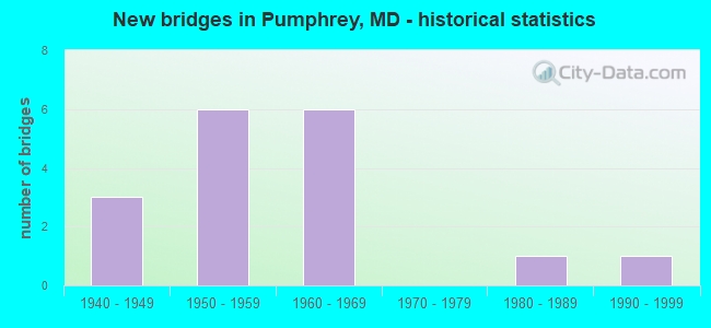
- New bridges - historical statistics
- 31940-1949
- 61950-1959
- 61960-1969
- 11980-1989
- 11990-1999

- Reconstructed bridges - Historical Statistics
- 11960-1969
- 31970-1979


- Bridge Condition - Deck
- 18.2%Good
- 54.5%Satisfactory
- 27.3%Fair

- Bridge Condition - Superstructure
- 9.1%Good
- 63.6%Satisfactory
- 27.3%Fair

- Bridge Condition - Substructure
- 27.3%Good
- 45.5%Satisfactory
- 27.3%Fair

- Bridge Condition - Channel
- 25.0%Good
- 25.0%Satisfactory
- 25.0%Fair
- 25.0%Poor
Find on map >> Show street view
Structure Number: 10000002000101, Location: BALTIMORE COUNTY LINE (Lat: 39.228847, Lng: -76.664739), Route carried "on" structure: Interstate 695, Year Built: 1958, Year Reconstructed: 1968, Status: Open, Structure Length: 41.82m (137.20ft), Average Daily Traffic: 120,772 (year 2009), Truck Traffic: 12%, Average Future Daily Traffic: 143,000 (year 2028), Design Load: HS 20+Mod, Features Intersected: PATAPSCO RIVER
Minimum Vertical Clearance: 30+ m (98+ ft), Kilometerpoint: 4.698, Lanes on structure: 6, Lanes under structure: 2, Base Highway Network: Yes, Owner: State Highway Agency, Approaching Roadway Width: 18.9m (62.0ft), Skew: 20 degrees, Material/Design: Steel, Design/Construction: Stringer/Multi-beam, Number Of Spans In Main Unit: 26, Length of Maximum Span: 22.3m (73.2ft), Curb-To-Curb Width: 37.2m (122.0ft), Out-to-Out Width: 40.3m (132.2ft)
Condition: Deck: Satisfactory, Superstructure: Satisfactory, Substructure: Fair, Channel: Poor, Operating Rating: 48.1 metric tons, Method Used To Determine Operating Rating: Load Factor (LF), Inventory Rating: 29.0 metric tons, Method Used To Determine Inventory Rating: Load Factor (LF), Structural Evaluation: Somewhat better than minimum adequacy, Deck Geometry: Superior to present desirable criteria, Underclear: Meets minimum limits, Waterway Adequacy: Equal to present minimum criteria, Approach Roadway Alignment: Equal to present minimum criteria, Length Of Structure Improvement: 41.82m (137.20ft), Designated Inspection Frequency: Every 24 months, Underwater Inspection Frequency: Every 48 months, Inspection Date: December 2020, Underwater Inspection Date: June 2019, Bridge Improvement Cost: $10,883,000, Roadway Improvement Cost: $1,088,000, Total Project Cost: $11,971,000, Deck Structure Type: Concrete Cast-file-Place, Wearing Surface/Protective System: Wearing Surface: Bituminous
Find on map >> Show street view
Structure Number: 10000002000301, Location: 0.38 MI S OF MD 168 (Lat: 39.219350, Lng: -76.658256), Route carried "on" structure: Interstate 695, Year Built: 1951, Year Reconstructed: 1977, Status: Open, Structure Length: 1.80m (5.91ft), Average Daily Traffic: 128,182 (year 2009), Truck Traffic: 8%, Average Future Daily Traffic: 139,484 (year 2026), Design Load: HS 20, Features Intersected: MD 295 NBR
Minimum Vertical Clearance: 30+ m (98+ ft), Kilometerpoint: 3.315, Lanes on structure: 8, Lanes under structure: 4, Base Highway Network: Yes, Owner: State Highway Agency, Approaching Roadway Width: 40.8m (133.9ft), Skew: 30 degrees, Material/Design: Steel, Design/Construction: Stringer/Multi-beam, Number Of Spans In Main Unit: 1, Length of Maximum Span: 16.8m (55.1ft), Curb-To-Curb Width: 36.1m (118.4ft), Out-to-Out Width: 37.9m (124.3ft)
Condition: Deck: Satisfactory, Superstructure: Satisfactory, Substructure: Satisfactory, Inventory Rating: 58.0 metric tons, Method Used To Determine Inventory Rating: Load Factor (LF), Structural Evaluation: Equal to present minimum criteria, Deck Geometry: Better than present minimum criteria, Underclear: High priority of corrective action, Approach Roadway Alignment: Equal to present desirable criteria, Length Of Structure Improvement: 1.80m (5.91ft), Designated Inspection Frequency: Every 24 months, Inspection Date: January 2020, Bridge Improvement Cost: $144,000, Roadway Improvement Cost: $14,000, Total Project Cost: $158,000, Deck Structure Type: Concrete Cast-file-Place, Wearing Surface/Protective System: Wearing Surface: Monolithic Concrete
Find on map >> Show street view
Structure Number: 100000020011011, Location: ON BALT CO LINE (Lat: 39.228850, Lng: -76.650167), Route carried "on" structure: State highway 295, Year Built: 1949, Year Reconstructed: 1984, Status: Open, Structure Length: 10.73m (35.20ft), Average Daily Traffic: 80,822 (year 2009), Truck Traffic: 8%, Average Future Daily Traffic: 45,573 (year 2026), Design Load: HS 20, Features Intersected: PATAPSCO RIVER
Minimum Vertical Clearance: 30+ m (98+ ft), Kilometerpoint: 24.246, Lanes on structure: 3, Base Highway Network: Yes, Owner: State Highway Agency, Approaching Roadway Width: 13.4m (44.0ft), Skew: 1 degrees, Material/Design: Steel, Design/Construction: Stringer/Multi-beam, Number Of Spans In Main Unit: 5, Length of Maximum Span: 21.3m (69.9ft), Curb-To-Curb Width: 13.7m (44.9ft), Out-to-Out Width: 14.7m (48.2ft)
Condition: Deck: Satisfactory, Superstructure: Satisfactory, Substructure: Fair, Channel: Good, Inventory Rating: 68.9 metric tons, Method Used To Determine Inventory Rating: Load Factor (LF), Structural Evaluation: Somewhat better than minimum adequacy, Deck Geometry: Meets minimum limits, Waterway Adequacy: Superior to present desirable criteria, Approach Roadway Alignment: Equal to present desirable criteria, Length Of Structure Improvement: 10.73m (35.20ft), Designated Inspection Frequency: Every 24 months, Inspection Date: October 2021, Bridge Improvement Cost: $1,018,000, Roadway Improvement Cost: $102,000, Total Project Cost: $1,120,000, Deck Structure Type: Concrete Cast-file-Place, Wearing Surface/Protective System: Wearing Surface: Bituminous
Find on map >> Show street view
Structure Number: 10000002001201, Location: 0.49 MI E OF IS 695 (Lat: 39.222847, Lng: -76.652506), Route carried "on" structure: State highway 168, Year Built: 1949, Year Reconstructed: 1979, Status: Open, Structure Length: 1.86m (6.10ft), Average Daily Traffic: 13,660 (year 2009), Truck Traffic: 8%, Average Future Daily Traffic: 16,672 (year 2026), Design Load: H 20, Features Intersected: MD 295 NBR
Minimum Vertical Clearance: 30+ m (98+ ft), Kilometerpoint: 1.126, Lanes on structure: 2, Lanes under structure: 3, Owner: State Highway Agency, Approaching Roadway Width: 13.4m (44.0ft), Skew: 1 degrees, Material/Design: Steel, Design/Construction: Stringer/Multi-beam, Number Of Spans In Main Unit: 1, Length of Maximum Span: 17.4m (57.1ft), Curb or Sidewalk Widths: Left: 1.2m (3.9ft), Right: 1.2m (3.9ft), Curb-To-Curb Width: 13.4m (44.0ft), Out-to-Out Width: 16.8m (55.1ft)
Condition: Deck: Satisfactory, Superstructure: Satisfactory, Substructure: Satisfactory, Operating Rating: 59.9 metric tons, Method Used To Determine Operating Rating: Load Factor (LF), Inventory Rating: 40.8 metric tons, Method Used To Determine Inventory Rating: Load Factor (LF), Structural Evaluation: Equal to present minimum criteria, Deck Geometry: Equal to present minimum criteria, Underclear: High priority of corrective action, Approach Roadway Alignment: Equal to present desirable criteria, Length Of Structure Improvement: 1.86m (6.10ft), Designated Inspection Frequency: Every 24 months, Inspection Date: October 2020, Bridge Improvement Cost: $202,000, Roadway Improvement Cost: $20,000, Total Project Cost: $222,000, Deck Structure Type: Concrete Cast-file-Place, Wearing Surface/Protective System: Wearing Surface: Bituminous
Find on map >> Show street view
Structure Number: 10000002005601, Location: ON BALTIMORE COUNTY LINE (Lat: 39.224861, Lng: -76.641522), Route carried "on" structure: State highway 648E, Year Built: 1992, Status: Open, Structure Length: 12.80m (41.99ft), Average Daily Traffic: 12,630 (year 2009), Truck Traffic: 8%, Average Future Daily Traffic: 15,266 (year 2026), Design Load: HS 20, Features Intersected: PATAPSCO RIVER
Minimum Vertical Clearance: 30+ m (98+ ft), Kilometerpoint: 12.598, Lanes on structure: 2, Owner: State Highway Agency, Approaching Roadway Width: 11.6m (38.1ft), Skew: 4 degrees, Material/Design: Steel, Design/Construction: Stringer/Multi-beam, Number Of Spans In Main Unit: 4, Length of Maximum Span: 34.7m (113.8ft), Curb or Sidewalk Widths: Left: 0.0m, Right: 1.6m (5.2ft), Curb-To-Curb Width: 11.6m (38.1ft), Out-to-Out Width: 14.1m (46.3ft)
Condition: Deck: Good, Superstructure: Good, Substructure: Satisfactory, Channel: Fair, Inventory Rating: 57.1 metric tons, Method Used To Determine Inventory Rating: Load Factor (LF), Structural Evaluation: Equal to present minimum criteria, Deck Geometry: Somewhat better than minimum adequacy, Waterway Adequacy: Superior to present desirable criteria, Approach Roadway Alignment: Equal to present desirable criteria, Designated Inspection Frequency: Every 24 months, Underwater Inspection Frequency: Every 48 months, Inspection Date: August 2021, Underwater Inspection Date: January 2020, Deck Structure Type: Concrete Cast-file-Place, Wearing Surface/Protective System: Wearing Surface: Monolithic Concrete, Deck Protection: Epoxy Coated Reinforcing
Find on map >> Show street view
Structure Number: 10000002007701, Location: ON AA CO/ BALTO CO LINE (Lat: 39.230250, Lng: -76.664703), Route carried "on" structure: County highway 17, Year Built: 1961, Status: Open, Structure Length: 9.24m (30.31ft), Average Daily Traffic: 8,800 (year 2006), Truck Traffic: 5%, Average Future Daily Traffic: 10,146 (year 2026), Design Load: HS 20, Features Intersected: PATAPSCO RIVER, Facility Carried by Structure: HAMMONDS FERRY RD
Minimum Vertical Clearance: 30+ m (98+ ft), Kilometerpoint: 4.055, Lanes on structure: 2, Owner: State Highway Agency, Approaching Roadway Width: 13.4m (44.0ft), Skew: 3 degrees, Material/Design: Steel, Design/Construction: Stringer/Multi-beam, Number Of Spans In Main Unit: 5, Length of Maximum Span: 18.3m (60.0ft), Curb or Sidewalk Widths: Left: 1.6m (5.2ft), Right: 0.0m, Curb-To-Curb Width: 9.1m (29.9ft), Out-to-Out Width: 11.9m (39.0ft)
Condition: Deck: Fair, Superstructure: Satisfactory, Substructure: Fair, Channel: Satisfactory, Operating Rating: 62.6 metric tons, Method Used To Determine Operating Rating: Load Factor (LF), Inventory Rating: 37.6 metric tons, Method Used To Determine Inventory Rating: Load Factor (LF), Structural Evaluation: Somewhat better than minimum adequacy, Deck Geometry: Meets minimum limits, Waterway Adequacy: Equal to present desirable criteria, Approach Roadway Alignment: Equal to present desirable criteria, Length Of Structure Improvement: 9.24m (30.31ft), Designated Inspection Frequency: Every 24 months, Underwater Inspection Frequency: Every 48 months, Inspection Date: May 2020, Underwater Inspection Date: July 2018, Bridge Improvement Cost: $707,000, Roadway Improvement Cost: $71,000, Total Project Cost: $778,000, Deck Structure Type: Concrete Cast-file-Place, Wearing Surface/Protective System: Wearing Surface: Bituminous
Find on map >> Show street view
Structure Number: 10000002008901, Location: 0.04 MI N OF MD 170 (Lat: 39.210950, Lng: -76.648703), Route carried "on" structure: Ramp Interstate 695, Year Built: 1967, Status: Open, Structure Length: 10.82m (35.50ft), Average Daily Traffic: 2,874 (year 2018), Truck Traffic: 8%, Average Future Daily Traffic: 4,443 (year 2040), Design Load: HS 20, Features Intersected: MTA LIGHT RAIL
Minimum Vertical Clearance: 30+ m (98+ ft), Kilometerpoint: 0.193, Lanes on structure: 1, Owner: State Highway Agency, Approaching Roadway Width: 8.5m (27.9ft), Skew: 9 degrees, Material/Design: Concrete, Design/Construction: Slab, Number Of Spans In Main Unit: 6, Length of Maximum Span: 23.5m (77.1ft), Curb-To-Curb Width: 8.5m (27.9ft), Out-to-Out Width: 9.1m (29.9ft)
Condition: Deck: Fair, Superstructure: Fair, Substructure: Good, Operating Rating: 58.0 metric tons, Method Used To Determine Operating Rating: Load Factor (LF), Inventory Rating: 34.5 metric tons, Method Used To Determine Inventory Rating: Load Factor (LF), Structural Evaluation: Somewhat better than minimum adequacy, Deck Geometry: Superior to present desirable criteria, Underclear: Better than present minimum criteria, Waterway Adequacy: Equal to present desirable criteria, Approach Roadway Alignment: Equal to present desirable criteria, Length Of Structure Improvement: 10.82m (35.50ft), Designated Inspection Frequency: Every 12 months, Inspection Date: July 2021, Bridge Improvement Cost: $639,000, Roadway Improvement Cost: $64,000, Total Project Cost: $703,000, Deck Structure Type: Concrete Cast-file-Place, Wearing Surface/Protective System: Wearing Surface: Monolithic Concrete
Find on map >> Show street view
Structure Number: 100000020092015, Location: 0.48 MI N OF MD 648E (Lat: 39.210150, Lng: -76.648594), Route carried "on" structure: Interstate 695, Year Built: 1967, Status: Open, Structure Length: 11.19m (36.71ft), Average Daily Traffic: 74,085 (year 2015), Truck Traffic: 8%, Average Future Daily Traffic: 90,400 (year 2035), Design Load: HS 20, Features Intersected: MD 170, MTA LIGHT RAIL
Minimum Vertical Clearance: 30+ m (98+ ft), Kilometerpoint: 1.963, Lanes on structure: 4, Lanes under structure: 4, Base Highway Network: Yes, Owner: State Highway Agency, Approaching Roadway Width: 16.5m (54.1ft), Material/Design: Steel, Design/Construction: Stringer/Multi-beam, Number Of Spans In Main Unit: 7, Length of Maximum Span: 17.7m (58.1ft), Curb-To-Curb Width: 18.0m (59.1ft), Out-to-Out Width: 18.6m (61.0ft)
Condition: Deck: Satisfactory, Superstructure: Fair, Substructure: Satisfactory, Operating Rating: 58.0 metric tons, Method Used To Determine Operating Rating: Load Factor (LF), Inventory Rating: 34.9 metric tons, Method Used To Determine Inventory Rating: Load Factor (LF), Structural Evaluation: Somewhat better than minimum adequacy, Deck Geometry: Meets minimum limits, Underclear: High priority of corrective action, Waterway Adequacy: Superior to present desirable criteria, Approach Roadway Alignment: Better than present minimum criteria, Length Of Structure Improvement: 11.19m (36.71ft), Designated Inspection Frequency: Every 24 months, Inspection Date: May 2020, Bridge Improvement Cost: $1,343,000, Roadway Improvement Cost: $134,000, Total Project Cost: $1,477,000, Deck Structure Type: Concrete Cast-file-Place, Wearing Surface/Protective System: Wearing Surface: Bituminous
Find on map >> Show street view
Structure Number: 100000020092016, Location: 0.48 MI N OF MD 648E (Lat: 39.210525, Lng: -76.649872), Route carried "on" structure: Interstate 695, Year Built: 1967, Status: Open, Structure Length: 11.19m (36.71ft), Average Daily Traffic: 74,085 (year 2015), Truck Traffic: 8%, Average Future Daily Traffic: 90,400 (year 2035), Design Load: HS 20, Features Intersected: MD 170, MTA LIGHT RAIL
Minimum Vertical Clearance: 30+ m (98+ ft), Kilometerpoint: 1.963, Lanes on structure: 4, Lanes under structure: 4, Base Highway Network: Yes, Owner: State Highway Agency, Approaching Roadway Width: 16.5m (54.1ft), Material/Design: Steel, Design/Construction: Stringer/Multi-beam, Number Of Spans In Main Unit: 7, Length of Maximum Span: 20.7m (67.9ft), Curb-To-Curb Width: 18.0m (59.1ft), Out-to-Out Width: 18.6m (61.0ft)
Condition: Deck: Fair, Superstructure: Fair, Substructure: Satisfactory, Operating Rating: 58.0 metric tons, Method Used To Determine Operating Rating: Load Factor (LF), Inventory Rating: 34.9 metric tons, Method Used To Determine Inventory Rating: Load Factor (LF), Structural Evaluation: Somewhat better than minimum adequacy, Deck Geometry: Meets minimum limits, Underclear: High priority of corrective action, Waterway Adequacy: Superior to present desirable criteria, Approach Roadway Alignment: Equal to present minimum criteria, Length Of Structure Improvement: 11.19m (36.71ft), Designated Inspection Frequency: Every 24 months, Inspection Date: May 2020, Bridge Improvement Cost: $1,343,000, Roadway Improvement Cost: $134,000, Total Project Cost: $1,477,000, Deck Structure Type: Concrete Cast-file-Place, Wearing Surface/Protective System: Wearing Surface: Bituminous
Find on map >> Show street view
Structure Number: 10000002013401, Location: 0.31 M N OF BALTO CITY (Lat: 39.202911, Lng: -76.631683), Route carried "on" structure: Ramp Interstate 695, Year Built: 1989, Status: Open, Structure Length: 6.74m (22.11ft), Average Daily Traffic: 14,460 (year 2005), Truck Traffic: 8%, Average Future Daily Traffic: 16,672 (year 2026), Design Load: HS 20+Mod, Features Intersected: IS 97
Minimum Vertical Clearance: 30+ m (98+ ft), Kilometerpoint: 0.499, Lanes on structure: 2, Lanes under structure: 5, Base Highway Network: Yes, Owner: State Highway Agency, Approaching Roadway Width: 11.6m (38.1ft), Skew: 2 degrees, Material/Design: Steel continuous, Design/Construction: Stringer/Multi-beam, Number Of Spans In Main Unit: 2, Length of Maximum Span: 35.1m (115.2ft), Curb-To-Curb Width: 11.6m (38.1ft), Out-to-Out Width: 12.6m (41.3ft)
Condition: Deck: Good, Superstructure: Satisfactory, Substructure: Good, Inventory Rating: 59.9 metric tons, Method Used To Determine Inventory Rating: Load Factor (LF), Structural Evaluation: Equal to present minimum criteria, Deck Geometry: Superior to present desirable criteria, Underclear: Better than present minimum criteria, Approach Roadway Alignment: Equal to present desirable criteria, Designated Inspection Frequency: Every 24 months, Inspection Date: October 2021, Deck Structure Type: Concrete Cast-file-Place, Wearing Surface/Protective System: Wearing Surface: Monolithic Concrete, Deck Protection: Epoxy Coated Reinforcing
Find on map >> Show street view
Structure Number: 300000AAY04901, Location: Milepost 4.9 (Lat: 39.213547, Lng: -76.625397), Route carried "on" structure: County highway 164, Year Built: 1957, Status: Open, Structure Length: 6.43m (21.10ft), Average Daily Traffic: 7,776 (year 2019), Truck Traffic: 5%, Average Future Daily Traffic: 9,471 (year 2041), Design Load: HS 20, Features Intersected: I-895, Facility Carried by Structure: HAMMONDS LANE
Minimum Vertical Clearance: 30+ m (98+ ft), Kilometerpoint: 7.884, Lanes on structure: 2, Lanes under structure: 4, Owner: State Toll Authority, Approaching Roadway Width: 12.2m (40.0ft), Skew: 2 degrees, Material/Design: Steel, Design/Construction: Stringer/Multi-beam, Number Of Spans In Main Unit: 4, Length of Maximum Span: 22.3m (73.2ft), Curb or Sidewalk Widths: Left: 1.5m (4.9ft), Right: 1.5m (4.9ft), Curb-To-Curb Width: 9.1m (29.9ft), Out-to-Out Width: 13.0m (42.7ft)
Condition: Deck: Satisfactory, Superstructure: Satisfactory, Substructure: Good, Operating Rating: 54.9 metric tons, Method Used To Determine Operating Rating: Load Factor (LF), Inventory Rating: 33.1 metric tons, Method Used To Determine Inventory Rating: Load Factor (LF), Structural Evaluation: Equal to present minimum criteria, Deck Geometry: Meets minimum limits, Underclear: High priority of corrective action, Approach Roadway Alignment: Better than present minimum criteria, Designated Inspection Frequency: Every 24 months, Inspection Date: January 2020, Deck Structure Type: Closed Grating, Wearing Surface/Protective System: Wearing Surface: Latex Concrete
Find on map >> Show street view
Structure Number: 10000002000201, Location: 0.38 MI N OF MD 295 (Lat: 39.224281, Lng: -76.661394), Route carried "under" structure: State highway 168, Year Built: 1958, Structure Length: 0. m, Average Daily Traffic: 13,660 (year 2009), Features Intersected: MD 168, Facility Carried by Structure: IS 695
Minimum Vertical Clearance: 4.88m (16.01ft), Kilometerpoint: 0.338, Lanes on structure: 8, Lanes under structure: 2, Material/Design: Steel, Design/Construction: Stringer/Multi-beam, Length of Maximum Span: 19.8m (65.0ft)
Find on map >> Show street view
Structure Number: 10000002000301, Location: 0.41 MI S OF MD 168 (Lat: 39.219161, Lng: -76.658294), Route carried "under" structure: State highway 295, Year Built: 1951, Structure Length: 0. m, Average Daily Traffic: 80,822 (year 2009), Features Intersected: MD 295 NBR, Facility Carried by Structure: IS 695
Minimum Vertical Clearance: 5.49m (18.01ft), Kilometerpoint: 22.896, Lanes on structure: 2, Lanes under structure: 2, Material/Design: Steel, Design/Construction: Stringer/Multi-beam, Length of Maximum Span: 16.8m (55.1ft)
Find on map >> Show street view
Structure Number: 10000002001201, Location: 0.49 MI E OF IS 695 (Lat: 39.222847, Lng: -76.652506), Route carried "under" structure: State highway 295, Year Built: 1949, Structure Length: 0. m, Average Daily Traffic: 80,822 (year 2009), Features Intersected: MD 295 NBR, Facility Carried by Structure: MD 168
Minimum Vertical Clearance: 4.88m (16.01ft), Kilometerpoint: 23.556, Lanes on structure: 4, Lanes under structure: 3, Material/Design: Steel, Design/Construction: Stringer/Multi-beam, Length of Maximum Span: 17.4m (57.1ft)
Find on map >> Show street view
Structure Number: 100000020092015, Location: 0.41 MILE NORTH OF MD 169 (Lat: 39.210150, Lng: -76.648594), Route carried "under" structure: State highway 170, Year Built: 1967, Structure Length: 0. m, Average Daily Traffic: 11,711 (year 2009), Features Intersected: MD 170, MTA LIGHT RAIL, Facility Carried by Structure: IS 695 IL
Minimum Vertical Clearance: 5.49m (18.01ft), Kilometerpoint: 16.508, Lanes on structure: 4, Lanes under structure: 4, Material/Design: Steel, Design/Construction: Stringer/Multi-beam, Length of Maximum Span: 17.7m (58.1ft)
Find on map >> Show street view
Structure Number: 100000020092016, Location: 0.41 MILE NORTH OF MD 169 (Lat: 39.210525, Lng: -76.649872), Route carried "under" structure: State highway 170, Year Built: 1967, Structure Length: 0. m, Average Daily Traffic: 11,711 (year 2009), Features Intersected: MD 170, MTA LIGHT RAIL, Facility Carried by Structure: IS 695 OL
Minimum Vertical Clearance: 5.49m (18.01ft), Kilometerpoint: 16.508, Lanes on structure: 4, Lanes under structure: 4, Material/Design: Steel, Design/Construction: Stringer/Multi-beam, Length of Maximum Span: 20.7m (67.9ft)
Find on map >> Show street view
Structure Number: 10000002009901, Location: 0.37 MI S OF MD 168 (Lat: 39.219486, Lng: -76.658492), Route carried "under" structure: State highway 295, Year Built: 1951, Structure Length: 0. m, Average Daily Traffic: 80,822 (year 2009), Features Intersected: MD 295 SBR, Facility Carried by Structure: IS 695
Minimum Vertical Clearance: 4.88m (16.01ft), Kilometerpoint: 22.896, Lanes on structure: 2, Lanes under structure: 2, Material/Design: Steel, Design/Construction: Stringer/Multi-beam, Length of Maximum Span: 16.8m (55.1ft)