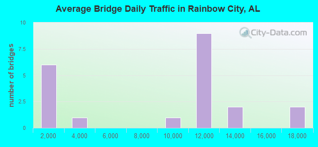
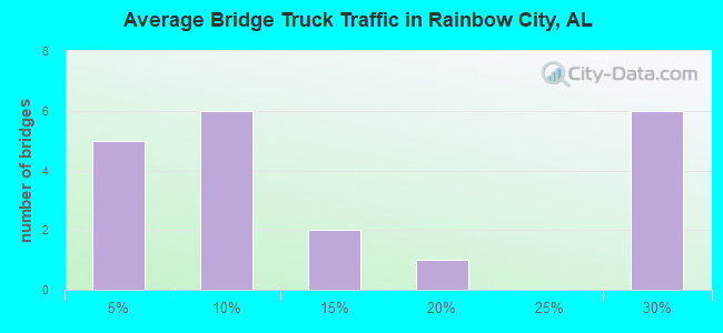
Bridge Statistics for Rainbow City, Alabama (AL)
Condition, Traffic, Stress, Structural Evaluation, Project Costs
- National Bridge Inventory (NBI) Statistics
- 21Number of bridges
- 217ft / 66.5mTotal length
- $32,739,000Total costs
- 173,832Total average daily traffic
- 25,298Total average daily truck traffic
- 226,449Total future (year 2029) average daily traffic
- National Bridge Inventory (NBI) Registered Bridges for Rainbow City
- No street view available for this location

- New bridges - historical statistics
- 11930-1939
- 21950-1959
- 81960-1969
- 11990-1999
- 32000-2009
- 62010-2019
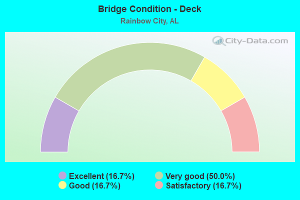
- Bridge Condition - Deck
- 16.7%Excellent
- 50.0%Very good
- 16.7%Good
- 16.7%Satisfactory
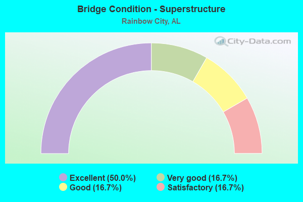
- Bridge Condition - Superstructure
- 50.0%Excellent
- 16.7%Very good
- 16.7%Good
- 16.7%Satisfactory
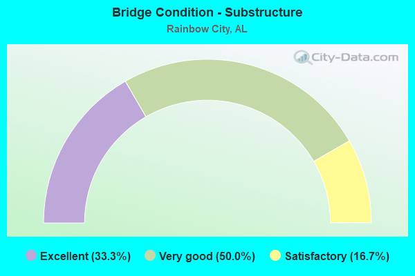
- Bridge Condition - Substructure
- 33.3%Excellent
- 50.0%Very good
- 16.7%Satisfactory
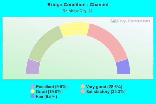
- Bridge Condition - Channel
- 9.5%Excellent
- 28.6%Very good
- 19.0%Good
- 33.3%Satisfactory
- 9.5%Fair
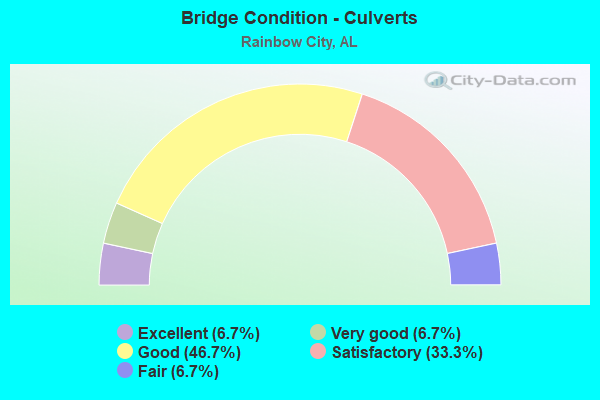
- Bridge Condition - Culverts
- 6.7%Excellent
- 6.7%Very good
- 46.7%Good
- 33.3%Satisfactory
- 6.7%Fair
Find on map >> Show street view
Structure Number: 2038, Location: CITY OF TALLADEGA (Lat: 33.438361, Lng: -86.103072), Route carried "on" structure: State highway 77, Year Built: 1939, Status: Open, Structure Length: 0.67m (2.20ft), Average Daily Traffic: 8,843 (year 2019), Truck Traffic: 4%, Average Future Daily Traffic: 12,380 (year 2039), Design Load: H 15, Features Intersected: BRANCH
Minimum Vertical Clearance: 30+ m (98+ ft), Kilometerpoint: 103.608, Lanes on structure: 2, Base Highway Network: Yes, Owner: State Highway Agency, Approaching Roadway Width: 11.6m (38.1ft), Material/Design: Masonry, Design/Construction: Culvert, Number Of Spans In Main Unit: 1, Length of Maximum Span: 6.1m (20.0ft)
Condition: Channel: Fair, Culverts: Fair, Operating Rating: 43.5 metric tons, Method Used To Determine Operating Rating: Field evaluation and documented engineering judgment, Inventory Rating: 32.7 metric tons, Method Used To Determine Inventory Rating: Field evaluation and documented engineering judgment, Structural Evaluation: Somewhat better than minimum adequacy, Waterway Adequacy: Equal to present minimum criteria, Approach Roadway Alignment: Equal to present desirable criteria, Length Of Structure Improvement: 1.30m (4.27ft), Designated Inspection Frequency: Every 24 months, Inspection Date: June 2021, Bridge Improvement Cost: $443,000, Roadway Improvement Cost: $44,000, Total Project Cost: $487,000 ( Estimate for 2022)
Find on map >> Show street view
Structure Number: 5633, Location: 200' N. OF STEELE STATION (Lat: 33.967956, Lng: -86.039158), Route carried "on" structure: County highway 129, Year Built: 1956, Status: Open, Structure Length: 1.10m (3.61ft), Average Daily Traffic: 10,500 (year 2005), Truck Traffic: 8%, Average Future Daily Traffic: 15,015 (year 2034), Design Load: H 15, Features Intersected: UT TO BIG WILLS CREEK, Facility Carried by Structure: SUTTON BRIDGE RD.
Minimum Vertical Clearance: 30+ m (98+ ft), Kilometerpoint: 0.010, Lanes on structure: 2, Owner: County Highway Agency, Approaching Roadway Width: 8.5m (27.9ft), Skew: 3 degrees, Material/Design: Concrete, Design/Construction: Culvert, Number Of Spans In Main Unit: 2, Length of Maximum Span: 3.7m (12.1ft)
Condition: Channel: Satisfactory, Culverts: Satisfactory, Operating Rating: 45.3 metric tons, Method Used To Determine Operating Rating: Load Factor (LF), Inventory Rating: 27.1 metric tons, Method Used To Determine Inventory Rating: Load Factor (LF), Structural Evaluation: Equal to present minimum criteria, Waterway Adequacy: Somewhat better than minimum adequacy, Approach Roadway Alignment: Equal to present desirable criteria, Length Of Structure Improvement: 1.77m (5.81ft), Designated Inspection Frequency: Every 24 months, Inspection Date: November 2020, Bridge Improvement Cost: $348,000, Roadway Improvement Cost: $35,000, Total Project Cost: $383,000 ( Estimate for 2022)
Find on map >> Show street view
Structure Number: 5634, Location: @ BROWN DRIVE (Lat: 33.988247, Lng: -86.046050), Route carried "on" structure: County highway 129, Year Built: 1956, Status: Open, Structure Length: 1.10m (3.61ft), Average Daily Traffic: 10,500 (year 2003), Truck Traffic: 10%, Average Future Daily Traffic: 10,500 (year 2034), Design Load: H 20, Features Intersected: BIG WILLS CREEK RELIEF, Facility Carried by Structure: SUTTON BRIDGE RD.
Minimum Vertical Clearance: 30+ m (98+ ft), Kilometerpoint: 0.010, Lanes on structure: 2, Owner: County Highway Agency, Approaching Roadway Width: 8.8m (28.9ft), Skew: 3 degrees, Material/Design: Concrete, Design/Construction: Culvert, Number Of Spans In Main Unit: 3, Length of Maximum Span: 3.7m (12.1ft)
Condition: Channel: Satisfactory, Culverts: Satisfactory, Operating Rating: 40.3 metric tons, Method Used To Determine Operating Rating: Load Factor (LF), Inventory Rating: 24.2 metric tons, Method Used To Determine Inventory Rating: Load Factor (LF), Structural Evaluation: Somewhat better than minimum adequacy, Waterway Adequacy: Equal to present minimum criteria, Approach Roadway Alignment: Equal to present minimum criteria, Length Of Structure Improvement: 1.77m (5.81ft), Designated Inspection Frequency: Every 24 months, Inspection Date: November 2020, Bridge Improvement Cost: $409,000, Roadway Improvement Cost: $41,000, Total Project Cost: $450,000 ( Estimate for 2022)
Find on map >> Show street view
Structure Number: 7135, Location: 0.25MINWOFHWY411 (Lat: 33.917814, Lng: -86.107322), Route carried "on" structure: County highway 119, Year Built: 1960, Status: Open, Structure Length: 1.31m (4.30ft), Average Daily Traffic: 868 (year 2003), Truck Traffic: 5%, Average Future Daily Traffic: 868 (year 2033), Design Load: H 20, Features Intersected: DRY CREEK, Facility Carried by Structure: PLEASENT VALLEY RD
Minimum Vertical Clearance: 30+ m (98+ ft), Kilometerpoint: 0.010, Lanes on structure: 2, Owner: County Highway Agency, Approaching Roadway Width: 8.5m (27.9ft), Material/Design: Concrete, Design/Construction: Culvert, Number Of Spans In Main Unit: 4, Length of Maximum Span: 3.3m (10.8ft)
Condition: Channel: Good, Culverts: Good, Operating Rating: 45.8 metric tons, Method Used To Determine Operating Rating: Load Factor (LF), Inventory Rating: 27.5 metric tons, Method Used To Determine Inventory Rating: Load Factor (LF), Structural Evaluation: Equal to present minimum criteria, Waterway Adequacy: Better than present minimum criteria, Approach Roadway Alignment: Equal to present desirable criteria, Length Of Structure Improvement: 1.98m (6.50ft), Designated Inspection Frequency: Every 24 months, Inspection Date: November 2021, Bridge Improvement Cost: $504,000, Roadway Improvement Cost: $50,000, Total Project Cost: $554,000 ( Estimate for 2022)
Find on map >> Show street view
Structure Number: 7538, Location: 1 . 5 MI N ST CLAIRCO LN (Lat: 33.955278, Lng: -86.142222), Route carried "on" structure: Interstate 59, Year Built: 1962, Status: Open, Structure Length: 0.76m (2.49ft), Average Daily Traffic: 12,646 (year 2019), Truck Traffic: 28%, Average Future Daily Traffic: 17,704 (year 2039), Design Load: HS 20, Features Intersected: BRANCH
Minimum Vertical Clearance: 30+ m (98+ ft), Kilometerpoint: 284.759, Lanes on structure: 2, Base Highway Network: Yes, Owner: State Highway Agency, Approaching Roadway Width: 7.3m (24.0ft), Skew: 3 degrees, Material/Design: Concrete, Design/Construction: Culvert, Number Of Spans In Main Unit: 2, Length of Maximum Span: 3.0m (9.8ft)
Condition: Channel: Good, Culverts: Good, Operating Rating: 88.9 metric tons, Method Used To Determine Operating Rating: Load Factor (LF), Inventory Rating: 88.9 metric tons, Method Used To Determine Inventory Rating: Load Factor (LF), Structural Evaluation: Better than present minimum criteria, Waterway Adequacy: Equal to present desirable criteria, Approach Roadway Alignment: Equal to present desirable criteria, Length Of Structure Improvement: 1.41m (4.63ft), Designated Inspection Frequency: Every 24 months, Inspection Date: July 2021, Bridge Improvement Cost: $854,000, Roadway Improvement Cost: $85,000, Total Project Cost: $939,000 ( Estimate for 2022)
Find on map >> Show street view
Structure Number: 7539, Location: 1 . 5 MI N ST CLAIR CO LN (Lat: 33.955375, Lng: -86.140550), Route carried "on" structure: Interstate 59, Year Built: 1962, Status: Open, Structure Length: 0.76m (2.49ft), Average Daily Traffic: 12,646 (year 2019), Truck Traffic: 28%, Average Future Daily Traffic: 17,704 (year 2039), Design Load: HS 20, Features Intersected: BRANCH
Minimum Vertical Clearance: 30+ m (98+ ft), Kilometerpoint: 284.759, Lanes on structure: 2, Base Highway Network: Yes, Owner: State Highway Agency, Approaching Roadway Width: 7.3m (24.0ft), Material/Design: Concrete, Design/Construction: Culvert, Number Of Spans In Main Unit: 2, Length of Maximum Span: 3.0m (9.8ft)
Condition: Channel: Fair, Culverts: Satisfactory, Operating Rating: 88.9 metric tons, Method Used To Determine Operating Rating: Load Factor (LF), Inventory Rating: 88.9 metric tons, Method Used To Determine Inventory Rating: Load Factor (LF), Structural Evaluation: Equal to present minimum criteria, Waterway Adequacy: Equal to present desirable criteria, Approach Roadway Alignment: Equal to present desirable criteria, Length Of Structure Improvement: 1.41m (4.63ft), Designated Inspection Frequency: Every 24 months, Inspection Date: July 2021, Bridge Improvement Cost: $756,000, Roadway Improvement Cost: $76,000, Total Project Cost: $832,000 ( Estimate for 2022), Wearing Surface/Protective System: Wearing Surface: Bituminous
Find on map >> Show street view
Structure Number: 754, Location: 1.9 MI NO ST CLAIR CO LN (Lat: 33.958453, Lng: -86.136911), Route carried "on" structure: Interstate 59, Year Built: 1962, Status: Open, Structure Length: 1.13m (3.71ft), Average Daily Traffic: 11,357 (year 2020), Truck Traffic: 28%, Average Future Daily Traffic: 15,900 (year 2040), Design Load: HS 20, Features Intersected: BRANCH
Minimum Vertical Clearance: 30+ m (98+ ft), Kilometerpoint: 285.322, Lanes on structure: 2, Base Highway Network: Yes, Owner: State Highway Agency, Approaching Roadway Width: 7.3m (24.0ft), Skew: 3 degrees, Material/Design: Concrete, Design/Construction: Culvert, Number Of Spans In Main Unit: 3, Length of Maximum Span: 3.0m (9.8ft)
Condition: Channel: Satisfactory, Culverts: Satisfactory, Operating Rating: 88.9 metric tons, Method Used To Determine Operating Rating: Load Factor (LF), Inventory Rating: 88.9 metric tons, Method Used To Determine Inventory Rating: Load Factor (LF), Structural Evaluation: Equal to present minimum criteria, Waterway Adequacy: Equal to present desirable criteria, Approach Roadway Alignment: Equal to present desirable criteria, Length Of Structure Improvement: 1.81m (5.94ft), Designated Inspection Frequency: Every 24 months, Inspection Date: August 2021, Bridge Improvement Cost: $990,000, Roadway Improvement Cost: $99,000, Total Project Cost: $1,089,000 ( Estimate for 2022)
Find on map >> Show street view
Structure Number: 7541, Location: 1.9 MI NO ST CLAIR CO LN (Lat: 33.957919, Lng: -86.135778), Route carried "on" structure: Interstate 59, Year Built: 1962, Status: Open, Structure Length: 1.13m (3.71ft), Average Daily Traffic: 11,357 (year 2020), Truck Traffic: 28%, Average Future Daily Traffic: 15,900 (year 2040), Design Load: HS 20, Features Intersected: BRANCH
Minimum Vertical Clearance: 30+ m (98+ ft), Kilometerpoint: 285.322, Lanes on structure: 2, Base Highway Network: Yes, Owner: State Highway Agency, Approaching Roadway Width: 7.3m (24.0ft), Skew: 3 degrees, Material/Design: Concrete, Design/Construction: Culvert, Number Of Spans In Main Unit: 3, Length of Maximum Span: 3.0m (9.8ft)
Condition: Channel: Satisfactory, Culverts: Satisfactory, Operating Rating: 88.9 metric tons, Method Used To Determine Operating Rating: Load Factor (LF), Inventory Rating: 88.9 metric tons, Method Used To Determine Inventory Rating: Load Factor (LF), Structural Evaluation: Equal to present minimum criteria, Waterway Adequacy: Equal to present desirable criteria, Approach Roadway Alignment: Equal to present desirable criteria, Length Of Structure Improvement: 1.81m (5.94ft), Designated Inspection Frequency: Every 24 months, Inspection Date: August 2021, Bridge Improvement Cost: $1,043,000, Roadway Improvement Cost: $104,000, Total Project Cost: $1,147,000 ( Estimate for 2022)
Find on map >> Show street view
Structure Number: 7542, Location: 2.5 MI NO ST CLAIR CO LN (Lat: 33.962858, Lng: -86.129775), Route carried "on" structure: Interstate 59, Year Built: 1962, Status: Open, Structure Length: 0.98m (3.22ft), Average Daily Traffic: 11,358 (year 2019), Truck Traffic: 28%, Average Future Daily Traffic: 15,901 (year 2039), Design Load: HS 20, Features Intersected: BRANCH
Minimum Vertical Clearance: 30+ m (98+ ft), Kilometerpoint: 286.386, Lanes on structure: 2, Base Highway Network: Yes, Owner: State Highway Agency, Approaching Roadway Width: 7.3m (24.0ft), Material/Design: Concrete, Design/Construction: Culvert, Number Of Spans In Main Unit: 3, Length of Maximum Span: 3.0m (9.8ft)
Condition: Channel: Satisfactory, Culverts: Good, Operating Rating: 88.9 metric tons, Method Used To Determine Operating Rating: Load Factor (LF), Inventory Rating: 88.9 metric tons, Method Used To Determine Inventory Rating: Load Factor (LF), Structural Evaluation: Better than present minimum criteria, Waterway Adequacy: Equal to present desirable criteria, Approach Roadway Alignment: Equal to present desirable criteria, Length Of Structure Improvement: 1.65m (5.41ft), Designated Inspection Frequency: Every 24 months, Inspection Date: July 2021, Bridge Improvement Cost: $764,000, Roadway Improvement Cost: $76,000, Total Project Cost: $840,000 ( Estimate for 2022), Wearing Surface/Protective System: Wearing Surface: Bituminous
Find on map >> Show street view
Structure Number: 7543, Location: 2 . 5 MI N ST CLAIR CO LN (Lat: 33.962253, Lng: -86.129444), Route carried "on" structure: Interstate 59, Year Built: 1962, Status: Open, Structure Length: 0.98m (3.22ft), Average Daily Traffic: 11,358 (year 2019), Truck Traffic: 28%, Average Future Daily Traffic: 15,901 (year 2039), Design Load: HS 20, Features Intersected: BRANCH
Minimum Vertical Clearance: 30+ m (98+ ft), Kilometerpoint: 286.386, Lanes on structure: 2, Base Highway Network: Yes, Owner: State Highway Agency, Approaching Roadway Width: 7.3m (24.0ft), Material/Design: Concrete, Design/Construction: Culvert, Number Of Spans In Main Unit: 3, Length of Maximum Span: 3.0m (9.8ft)
Condition: Channel: Satisfactory, Culverts: Good, Operating Rating: 88.9 metric tons, Method Used To Determine Operating Rating: Load Factor (LF), Inventory Rating: 88.9 metric tons, Method Used To Determine Inventory Rating: Load Factor (LF), Structural Evaluation: Better than present minimum criteria, Waterway Adequacy: Equal to present desirable criteria, Approach Roadway Alignment: Equal to present desirable criteria, Length Of Structure Improvement: 1.65m (5.41ft), Designated Inspection Frequency: Every 24 months, Inspection Date: July 2021, Bridge Improvement Cost: $917,000, Roadway Improvement Cost: $92,000, Total Project Cost: $1,009,000 ( Estimate for 2022), Wearing Surface/Protective System: Wearing Surface: Bituminous
Find on map >> Show street view
Structure Number: 9125, Location: 0 3 MI SE MCKNTYRE CHURCH (Lat: 33.858533, Lng: -86.095353), Route carried "on" structure: ServiceCounty highway 64, Year Built: 1966, Status: Posted for load, Structure Length: 5.18m (16.99ft), Average Daily Traffic: 500 (year 1999), Truck Traffic: 15%, Average Future Daily Traffic: 937 (year 2029), Design Load: H 15, Features Intersected: PERMETER CREEK
Minimum Vertical Clearance: 30+ m (98+ ft), Kilometerpoint: 0.010, Lanes on structure: 2, Owner: County Highway Agency, Approaching Roadway Width: 8.5m (27.9ft), Material/Design: Concrete, Design/Construction: Tee Beam, Number Of Spans In Main Unit: 5, Length of Maximum Span: 10.4m (34.1ft), Curb-To-Curb Width: 6.7m (22.0ft), Out-to-Out Width: 7.3m (24.0ft)
Condition: Deck: Satisfactory, Superstructure: Satisfactory, Substructure: Satisfactory, Channel: Good, Operating Rating: 39.6 metric tons, Method Used To Determine Operating Rating: Allowable Stress (AS), Inventory Rating: 23.3 metric tons, Method Used To Determine Inventory Rating: Allowable Stress (AS), Structural Evaluation: Equal to present minimum criteria, Deck Geometry: High priority of corrective action, Waterway Adequacy: Equal to present desirable criteria, Approach Roadway Alignment: Equal to present minimum criteria, Bridge Posting: Required (Relationship of Operating Rating to Maximum Legal Load: 10.0 - 19.9% below), Length Of Structure Improvement: 6.20m (20.34ft), Designated Inspection Frequency: Every 24 months, Underwater Inspection Frequency: Every 48 months, Other Special Inspection Frequency: Every 12 months, Inspection Date: January 2021, Underwater Inspection Date: Febuary 2021, Other Special Inspection Date: January 2022, Bridge Improvement Cost: $1,021,000, Roadway Improvement Cost: $102,000, Total Project Cost: $1,123,000 ( Estimate for 2022), Deck Structure Type: Concrete Cast-file-Place
Find on map >> Show street view
Structure Number: 16875, Location: 1.4 MI SW OF PLEASANT VLY (Lat: 33.967161, Lng: -86.130158), Route carried "on" structure: County highway , Year Built: 1997, Status: Open, Structure Length: 0.61m (2.00ft), Average Daily Traffic: 25 (year 2003), Average Future Daily Traffic: 47 (year 2035), Design Load: H 15, Features Intersected: ROOK CREEK, Facility Carried by Structure: WESSON LAKE RD.
Minimum Vertical Clearance: 0.00m, Kilometerpoint: 1.127, Lanes on structure: 2, Owner: County Highway Agency, Approaching Roadway Width: 5.7m (18.7ft), Material/Design: Steel, Design/Construction: Culvert, Number Of Spans In Main Unit: 2, Length of Maximum Span: 3.0m (9.8ft)
Condition: Channel: Satisfactory, Culverts: Good, Operating Rating: 88.9 metric tons, Method Used To Determine Operating Rating: Load Factor (LF), Inventory Rating: 88.9 metric tons, Method Used To Determine Inventory Rating: Load Factor (LF), Structural Evaluation: Better than present minimum criteria, Waterway Adequacy: Somewhat better than minimum adequacy, Approach Roadway Alignment: Equal to present minimum criteria, Length Of Structure Improvement: 1.22m (4.00ft), Designated Inspection Frequency: Every 24 months, Inspection Date: Febuary 2021, Bridge Improvement Cost: $268,000, Roadway Improvement Cost: $27,000, Total Project Cost: $295,000 ( Estimate for 2022)
Find on map >> Show street view
Structure Number: 17494, Location: AL 77 OVER HORTON CREEK (Lat: 33.980000, Lng: -86.066667), Route carried "on" structure: State highway 77, Year Built: 2013, Status: Open, Structure Length: 2.06m (6.76ft), Average Daily Traffic: 17,512 (year 2020), Truck Traffic: 6%, Average Future Daily Traffic: 24,517 (year 2040), Design Load: HS 20, Features Intersected: HORTON CREEK
Minimum Vertical Clearance: 30+ m (98+ ft), Kilometerpoint: 169.800, Lanes on structure: 5, Base Highway Network: Yes, Owner: State Highway Agency, Approaching Roadway Width: 25.8m (84.6ft), Material/Design: Concrete, Design/Construction: Culvert, Number Of Spans In Main Unit: 4, Length of Maximum Span: 5.0m (16.4ft)
Condition: Channel: Very good, Culverts: Good, Operating Rating: 85.5 metric tons, Method Used To Determine Operating Rating: Load Factor (LF), Inventory Rating: 51.3 metric tons, Method Used To Determine Inventory Rating: Load Factor (LF), Structural Evaluation: Better than present minimum criteria, Waterway Adequacy: Superior to present desirable criteria, Approach Roadway Alignment: Equal to present desirable criteria, Length Of Structure Improvement: 2.82m (9.25ft), Designated Inspection Frequency: Every 24 months, Inspection Date: September 2021, Bridge Improvement Cost: $1,418,000, Roadway Improvement Cost: $142,000, Total Project Cost: $1,560,000 ( Estimate for 2022)
Find on map >> Show street view
Structure Number: 18143, Location: BLACK CREEK PARKWAY (Lat: 33.989250, Lng: -86.039444), Route carried "on" structure: City street , Year Built: 2011, Status: Open, Structure Length: 12.01m (39.40ft), Average Daily Traffic: 10,000 (year 2021), Truck Traffic: 1%, Average Future Daily Traffic: 10,500 (year 2041), Design Load: HS 20, Features Intersected: BIG WILLS CREEK, Facility Carried by Structure: BLACK CREEK PKWY
Minimum Vertical Clearance: 30+ m (98+ ft), Kilometerpoint: 0.002, Lanes on structure: 2, Owner: City or Municipal Highway Agency, Approaching Roadway Width: 15.5m (50.9ft), Skew: 10 degrees, Material/Design: Prestressed concrete, Design/Construction: Stringer/Multi-beam, Number Of Spans In Main Unit: 2, Length of Maximum Span: 30.0m (98.4ft), Curb-To-Curb Width: 14.6m (47.9ft), Out-to-Out Width: 15.5m (50.9ft)
Condition: Deck: Very good, Superstructure: Excellent, Substructure: Very good, Channel: Very good, Operating Rating: 79.2 metric tons, Method Used To Determine Operating Rating: Load Factor (LF), Inventory Rating: 47.4 metric tons, Method Used To Determine Inventory Rating: Load Factor (LF), Structural Evaluation: Equal to present desirable criteria, Deck Geometry: Superior to present desirable criteria, Waterway Adequacy: Equal to present desirable criteria, Approach Roadway Alignment: Equal to present desirable criteria, Length Of Structure Improvement: 12.86m (42.19ft), Designated Inspection Frequency: Every 24 months, Underwater Inspection Frequency: Every 48 months, Inspection Date: May 2021, Underwater Inspection Date: December 2021, Bridge Improvement Cost: $4,498,000, Roadway Improvement Cost: $450,000, Total Project Cost: $4,948,000 ( Estimate for 2022), Deck Structure Type: Concrete Precast Panels
Find on map >> Show street view
Structure Number: 18212, Location: .1 MI JCT 411 (Lat: 33.903986, Lng: -86.110814), Route carried "on" structure: City street , Year Built: 2006, Status: Open, Structure Length: 7.44m (24.41ft), Average Daily Traffic: 600 (year 2020), Truck Traffic: 1%, Average Future Daily Traffic: 1,000 (year 2040), Design Load: HS 20, Features Intersected: DRY CREEK, Facility Carried by Structure: CANOE CREEK ROAD
Minimum Vertical Clearance: 30+ m (98+ ft), Kilometerpoint: 8.200, Lanes on structure: 2, Owner: City or Municipal Highway Agency, Approaching Roadway Width: 7.3m (24.0ft), Material/Design: Prestressed concrete, Design/Construction: Stringer/Multi-beam, Number Of Spans In Main Unit: 3, Length of Maximum Span: 25.0m (82.0ft), Curb-To-Curb Width: 12.0m (39.4ft), Out-to-Out Width: 12.8m (42.0ft)
Condition: Deck: Very good, Superstructure: Very good, Substructure: Very good, Channel: Very good, Operating Rating: 88.9 metric tons, Method Used To Determine Operating Rating: Load Factor (LF), Inventory Rating: 40.1 metric tons, Method Used To Determine Inventory Rating: Load Factor (LF), Structural Evaluation: Equal to present desirable criteria, Deck Geometry: Better than present minimum criteria, Waterway Adequacy: Superior to present desirable criteria, Approach Roadway Alignment: Superior to present desirable criteria, Length Of Structure Improvement: 8.46m (27.76ft), Designated Inspection Frequency: Every 24 months, Underwater Inspection Frequency: Every 48 months, Inspection Date: December 2020, Underwater Inspection Date: December 2021, Bridge Improvement Cost: $2,437,000, Roadway Improvement Cost: $244,000, Total Project Cost: $2,681,000 ( Estimate for 2022), Deck Structure Type: Concrete Cast-file-Place
Find on map >> Show street view
Structure Number: 18213, Location: ST. CLAIR/ETOWAH CO.LN. (Lat: 33.902986, Lng: -86.110564), Route carried "on" structure: US 411, Year Built: 2007, Status: Open, Structure Length: 10.80m (35.43ft), Average Daily Traffic: 3,400 (year 2021), Truck Traffic: 4%, Average Future Daily Traffic: 4,508 (year 2041), Design Load: HS 20, Features Intersected: BIG CANOE CREEK
Minimum Vertical Clearance: 30.18m (99.02ft), Kilometerpoint: 333.572, Lanes on structure: 2, Owner: State Highway Agency, Approaching Roadway Width: 12.1m (39.7ft), Material/Design: Prestressed concrete, Design/Construction: Stringer/Multi-beam, Number Of Spans In Main Unit: 4, Length of Maximum Span: 27.0m (88.6ft), Curb-To-Curb Width: 13.2m (43.3ft), Out-to-Out Width: 14.0m (45.9ft)
Condition: Deck: Good, Superstructure: Good, Substructure: Very good, Channel: Very good, Operating Rating: 68.1 metric tons, Method Used To Determine Operating Rating: Load Factor (LF), Inventory Rating: 40.7 metric tons, Method Used To Determine Inventory Rating: Load Factor (LF), Structural Evaluation: Better than present minimum criteria, Deck Geometry: Equal to present minimum criteria, Waterway Adequacy: Equal to present desirable criteria, Approach Roadway Alignment: Equal to present desirable criteria, Length Of Structure Improvement: 11.70m (38.39ft), Designated Inspection Frequency: Every 24 months, Underwater Inspection Frequency: Every 24 months, Inspection Date: April 2021, Underwater Inspection Date: August 2020, Bridge Improvement Cost: $3,689,000, Roadway Improvement Cost: $369,000, Total Project Cost: $4,058,000 ( Estimate for 2022), Deck Structure Type: Concrete Cast-file-Place
Find on map >> Show street view
Structure Number: 18554, Location: BLACK CREEK PARKWAY (Lat: 33.989258, Lng: -86.040000), Route carried "on" structure: City street , Year Built: 2011, Status: Open, Structure Length: 12.01m (39.40ft), Average Daily Traffic: 10,500 (year 2021), Truck Traffic: 1%, Average Future Daily Traffic: 10,500 (year 2041), Design Load: HS 20, Features Intersected: BIG WILLS CREEK, Facility Carried by Structure: BLACK CREEK PKY
Minimum Vertical Clearance: 30+ m (98+ ft), Kilometerpoint: 0.000, Lanes on structure: 2, Owner: City or Municipal Highway Agency, Approaching Roadway Width: 12.8m (42.0ft), Skew: 10 degrees, Material/Design: Prestressed concrete, Design/Construction: Stringer/Multi-beam, Number Of Spans In Main Unit: 4, Length of Maximum Span: 30.0m (98.4ft), Curb-To-Curb Width: 12.2m (40.0ft), Out-to-Out Width: 13.4m (44.0ft)
Condition: Deck: Very good, Superstructure: Excellent, Substructure: Excellent, Channel: Very good, Operating Rating: 79.4 metric tons, Method Used To Determine Operating Rating: Load Factor (LF), Inventory Rating: 51.2 metric tons, Method Used To Determine Inventory Rating: Load Factor (LF), Structural Evaluation: Superior to present desirable criteria, Deck Geometry: Better than present minimum criteria, Waterway Adequacy: Equal to present desirable criteria, Approach Roadway Alignment: Equal to present desirable criteria, Length Of Structure Improvement: 12.86m (42.19ft), Designated Inspection Frequency: Every 24 months, Underwater Inspection Frequency: Every 48 months, Inspection Date: May 2021, Underwater Inspection Date: December 2021, Bridge Improvement Cost: $3,881,000, Roadway Improvement Cost: $388,000, Total Project Cost: $4,269,000 ( Estimate for 2022), Deck Structure Type: Concrete Precast Panels
Find on map >> Show street view
Structure Number: 18555, Location: BLACK CREEK PARKWAY (Lat: 33.985742, Lng: -86.042903), Route carried "on" structure: City street , Year Built: 2011, Status: Open, Structure Length: 2.12m (6.96ft), Average Daily Traffic: 10,500 (year 2021), Truck Traffic: 5%, Average Future Daily Traffic: 10,500 (year 2041), Design Load: HS 20, Features Intersected: BIG WILLS CREEK, Facility Carried by Structure: BLACK CREEK PKWY
Minimum Vertical Clearance: 30+ m (98+ ft), Kilometerpoint: 0.000, Lanes on structure: 2, Owner: City or Municipal Highway Agency, Approaching Roadway Width: 6.7m (22.0ft), Skew: 6 degrees, Material/Design: Concrete, Design/Construction: Culvert, Number Of Spans In Main Unit: 3, Length of Maximum Span: 3.0m (9.8ft)
Condition: Channel: Very good, Culverts: Very good, Operating Rating: 88.9 metric tons, Method Used To Determine Operating Rating: Load Factor (LF), Inventory Rating: 60.6 metric tons, Method Used To Determine Inventory Rating: Load Factor (LF), Structural Evaluation: Equal to present desirable criteria, Waterway Adequacy: Equal to present desirable criteria, Approach Roadway Alignment: Equal to present desirable criteria, Length Of Structure Improvement: 2.90m (9.51ft), Designated Inspection Frequency: Every 24 months, Inspection Date: May 2021, Bridge Improvement Cost: $3,301,000, Roadway Improvement Cost: $330,000, Total Project Cost: $3,631,000 ( Estimate for 2022)
Find on map >> Show street view
Structure Number: 19315, Location: AL 77 AND DRY CREEK (Lat: 33.964536, Lng: -86.046036), Route carried "on" structure: State highway 77, Year Built: 2004, Status: Open, Structure Length: 1.26m (4.13ft), Average Daily Traffic: 17,512 (year 2019), Truck Traffic: 6%, Average Future Daily Traffic: 24,517 (year 2039), Design Load: HS 20, Features Intersected: DRY CREEK
Minimum Vertical Clearance: 30+ m (98+ ft), Kilometerpoint: 167.109, Lanes on structure: 5, Base Highway Network: Yes, Owner: State Highway Agency, Approaching Roadway Width: 27.4m (89.9ft), Material/Design: Concrete, Design/Construction: Culvert, Number Of Spans In Main Unit: 4, Length of Maximum Span: 3.0m (9.8ft)
Condition: Channel: Good, Culverts: Good, Operating Rating: 60.7 metric tons, Method Used To Determine Operating Rating: Load Factor (LF), Inventory Rating: 36.4 metric tons, Method Used To Determine Inventory Rating: Load Factor (LF), Structural Evaluation: Better than present minimum criteria, Waterway Adequacy: Equal to present desirable criteria, Approach Roadway Alignment: Equal to present desirable criteria, Length Of Structure Improvement: 1.94m (6.36ft), Designated Inspection Frequency: Every 24 months, Inspection Date: June 2021, Bridge Improvement Cost: $1,099,000, Roadway Improvement Cost: $110,000, Total Project Cost: $1,209,000 ( Estimate for 2022), Wearing Surface/Protective System: Wearing Surface: Bituminous
Find on map >> Show street view
Structure Number: 2038, Location: PEERMAN LAKE RD> (Lat: 33.952139, Lng: -86.100472), Route carried "on" structure: City street , Year Built: 2010, Status: Open, Structure Length: 1.22m (4.00ft), Average Daily Traffic: 350 (year 2022), Truck Traffic: 5%, Average Future Daily Traffic: 400 (year 2042), Design Load: HS 20, Features Intersected: CITY STREET * WATERWAY, Facility Carried by Structure: CITY STREET
Minimum Vertical Clearance: 30+ m (98+ ft), Kilometerpoint: 0.000, Lanes on structure: 2, Owner: City or Municipal Highway Agency, Approaching Roadway Width: 6.7m (22.0ft), Material/Design: Concrete, Design/Construction: Channel Beam, Number Of Spans In Main Unit: 2, Length of Maximum Span: 12.2m (40.0ft), Curb-To-Curb Width: 8.6m (28.2ft), Out-to-Out Width: 9.4m (30.8ft)
Condition: Deck: Excellent, Superstructure: Excellent, Substructure: Excellent, Channel: Excellent, Operating Rating: 88.9 metric tons, Method Used To Determine Operating Rating: Load Factor (LF), Inventory Rating: 55.1 metric tons, Method Used To Determine Inventory Rating: Load Factor (LF), Structural Evaluation: Superior to present desirable criteria, Deck Geometry: Equal to present minimum criteria, Waterway Adequacy: Equal to present minimum criteria, Approach Roadway Alignment: Better than present minimum criteria, Length Of Structure Improvement: 1.89m (6.20ft), Designated Inspection Frequency: Every 24 months, Inspection Date: January 2022, Bridge Improvement Cost: $389,000, Roadway Improvement Cost: $39,000, Total Project Cost: $428,000 ( Estimate for 2022), Deck Structure Type: Concrete Precast Panels, Wearing Surface/Protective System: Wearing Surface: Bituminous
Find on map >> Show street view
Structure Number: 20645, Location: 0.7 MI.W\PLEASANT VALLEY (Lat: 33.939089, Lng: -86.131331), Route carried "on" structure: County highway 124, Year Built: 2014, Status: Open, Structure Length: 1.83m (6.00ft), Average Daily Traffic: 1,500 (year 2009), Truck Traffic: 10%, Average Future Daily Traffic: 1,250 (year 2034), Design Load: HS 20, Features Intersected: ROOK CREEK, Facility Carried by Structure: STEELE STATION
Minimum Vertical Clearance: 30+ m (98+ ft), Kilometerpoint: 0.010, Lanes on structure: 2, Owner: County Highway Agency, Approaching Roadway Width: 7.3m (24.0ft), Skew: 1 degrees, Material/Design: Concrete, Design/Construction: Culvert, Number Of Spans In Main Unit: 4, Length of Maximum Span: 4.6m (15.1ft)
Condition: Channel: Excellent, Culverts: Excellent, Operating Rating: 77.5 metric tons, Method Used To Determine Operating Rating: Load Factor (LF), Inventory Rating: 46.4 metric tons, Method Used To Determine Inventory Rating: Load Factor (LF), Structural Evaluation: Superior to present desirable criteria, Waterway Adequacy: Equal to present desirable criteria, Approach Roadway Alignment: Equal to present desirable criteria, Length Of Structure Improvement: 2.54m (8.33ft), Designated Inspection Frequency: Every 24 months, Inspection Date: March 2020, Bridge Improvement Cost: $734,000, Roadway Improvement Cost: $73,000, Total Project Cost: $807,000 ( Estimate for 2022), Wearing Surface/Protective System: Wearing Surface: Bituminous