Bridge Statistics for Rainier, Oregon (OR)
Condition, Traffic, Stress, Structural Evaluation, Project Costs
- National Bridge Inventory (NBI) Statistics
- 13Number of bridges
- 633ft / 193mTotal length
- $3,682,000Total costs
- 51,190Total average daily traffic
- 6,481Total average daily truck traffic
- National Bridge Inventory (NBI) Registered Bridges for Rainier
- No street view available for this location
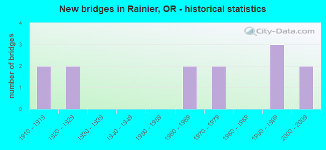
- New bridges - historical statistics
- 21910-1919
- 21920-1929
- 21960-1969
- 21970-1979
- 31990-1999
- 22000-2009


- Bridge Condition - Deck
- 18.2%Very good
- 54.5%Good
- 18.2%Satisfactory
- 9.1%Poor

- Bridge Condition - Superstructure
- 18.2%Very good
- 45.5%Good
- 18.2%Satisfactory
- 9.1%Fair
- 9.1%Poor

- Bridge Condition - Substructure
- 18.2%Very good
- 36.4%Good
- 36.4%Satisfactory
- 9.1%Fair

- Bridge Condition - Channel
- 10.0%Very good
- 60.0%Good
- 20.0%Satisfactory
- 10.0%Fair
Find on map >> Show street view
Structure Number: 2046 02WC04892, Location: WASH. STATE LINE (Lat: 46.105231, Lng: -122.961350), Route carried "on" structure: State highway 30, Year Built: 1929, Year Reconstructed: 2003, Status: Open, Structure Length: 166.97m (547.80ft), Average Daily Traffic: 20,566 (year 2020), Truck Traffic: 18%, Average Future Daily Traffic: 13,500 (year 2038), Design Load: H 20, Features Intersected: COLUMBIA R (LONGVIEW BR), Facility Carried by Structure: HWY 2W CONN
Minimum Vertical Clearance: 6.02m (19.75ft), Kilometerpoint: 78.729, Lanes on structure: 2, Lanes under structure: 6, Base Highway Network: Yes, Owner: State Highway Agency, Approaching Roadway Width: 9.1m (29.9ft), Navigation Control: Yes ( Vertical Clearance: 60.4m (198.2ft), Horizontal Clearance: 319.7m (1,048.9ft)), Material/Design: Steel continuous, Design/Construction: Truss - Thru, Number Of Spans In Main Unit: 3, Number Of Approach Spans: 31, Length of Maximum Span: 365.8m (1,200.1ft), Curb-To-Curb Width: 10.4m (34.1ft), Out-to-Out Width: 10.7m (35.1ft)
Condition: Deck: Satisfactory, Superstructure: Satisfactory, Substructure: Fair, Channel: Very good, Operating Rating: 35.4 metric tons, Method Used To Determine Operating Rating: Load Factor (LF), Inventory Rating: 20.9 metric tons, Method Used To Determine Inventory Rating: Load Factor (LF), Structural Evaluation: Somewhat better than minimum adequacy, Deck Geometry: Meets minimum limits, Underclear: Somewhat better than minimum adequacy, Waterway Adequacy: Equal to present desirable criteria, Approach Roadway Alignment: Equal to present desirable criteria, Designated Inspection Frequency: Every 24 months, Critical Feature Inspection Frequency: Every 24 months, Underwater Inspection Frequency: Every 60 months, Other Special Inspection Frequency: Every 24 months, Inspection Date: Febuary 2020, Critical Feature Inspection Date: Febuary 2020, Underwater Inspection Date: September 2020, Other Special Inspection Date: Febuary 2020, Deck Structure Type: Concrete Precast Panels, Wearing Surface/Protective System: Wearing Surface: Latex Concrete, Deck Protection: Epoxy Coated Reinforcing
Find on map >> Show street view
Structure Number: 9591 02WC04837, Location: 2.7 MI W RAINIER (Lat: 46.095581, Lng: -122.969469), Route carried "on" structure: Ramp US 30, Year Built: 1969, Status: Open, Structure Length: 7.22m (23.69ft), Average Daily Traffic: 10,102 (year 2020), Truck Traffic: 6%, Average Future Daily Traffic: 5,800 (year 2030), Design Load: HS 20, Features Intersected: HWY 2W, Facility Carried by Structure: LONGVIEW BR CONN
Minimum Vertical Clearance: 5.13m (16.83ft), Kilometerpoint: 77.828, Lanes on structure: 2, Lanes under structure: 4, Base Highway Network: Yes, Owner: State Highway Agency, Approaching Roadway Width: 13.4m (44.0ft), Material/Design: Concrete continuous, Design/Construction: Box Beam or Girders - Multiple, Number Of Spans In Main Unit: 3, Length of Maximum Span: 41.8m (137.1ft), Curb-To-Curb Width: 13.4m (44.0ft), Out-to-Out Width: 14.2m (46.6ft)
Condition: Deck: Good, Superstructure: Satisfactory, Substructure: Good, Operating Rating: 46.3 metric tons, Method Used To Determine Operating Rating: Load and Resistance Factor Rating (LRFR) rating reported by rating factor(RF) method using HL-93 loadings, Inventory Rating: 35.6 metric tons, Method Used To Determine Inventory Rating: Load and Resistance Factor Rating (LRFR) rating reported by rating factor(RF) method using HL-93 loadings, Structural Evaluation: Equal to present minimum criteria, Deck Geometry: Superior to present desirable criteria, Underclear: Equal to present minimum criteria, Approach Roadway Alignment: Equal to present desirable criteria, Length Of Structure Improvement: 7.20m (23.62ft), Designated Inspection Frequency: Every 24 months, Inspection Date: November 2021, Bridge Improvement Cost: $1,145,000, Roadway Improvement Cost: $114,000, Total Project Cost: $1,831,000, Deck Structure Type: Concrete Cast-file-Place, Wearing Surface/Protective System: Wearing Surface: Bituminous
Find on map >> Show street view
Structure Number: 9C01, Location: RAINIER OREGON WESTSIDE (Lat: 46.089600, Lng: -122.943300), Route carried "on" structure: City street C0000, Year Built: 1911, Status: Posted for load, Structure Length: 7.41m (24.31ft), Average Daily Traffic: 732 (year 2020), Truck Traffic: 10%, Average Future Daily Traffic: 822 (year 2025), Features Intersected: NICE CREEK, Facility Carried by Structure: C STREET WEST
Minimum Vertical Clearance: 30+ m (98+ ft), Kilometerpoint: 0.000, Lanes on structure: 1, Owner: City or Municipal Highway Agency, Approaching Roadway Width: 4.6m (15.1ft), Material/Design: Concrete continuous, Design/Construction: Tee Beam, Number Of Spans In Main Unit: 6, Length of Maximum Span: 12.2m (40.0ft), Curb-To-Curb Width: 4.8m (15.7ft), Out-to-Out Width: 6.2m (20.3ft)
Condition: Deck: Poor, Superstructure: Poor, Substructure: Satisfactory, Channel: Good, Operating Rating: 18.1 metric tons, Method Used To Determine Operating Rating: Load Factor (LF), Inventory Rating: 12.7 metric tons, Method Used To Determine Inventory Rating: Load Factor (LF), Structural Evaluation: Meets minimum limits, Deck Geometry: High priority of corrective action, Waterway Adequacy: Equal to present desirable criteria, Approach Roadway Alignment: Equal to present minimum criteria, Bridge Posting: Required (Relationship of Operating Rating to Maximum Legal Load: 0.1 - 9.9% below), Length Of Structure Improvement: 8.20m (26.90ft), Designated Inspection Frequency: Every 24 months, Inspection Date: May 2021, Bridge Improvement Cost: $856,000, Roadway Improvement Cost: $86,000, Total Project Cost: $1,370,000, Deck Structure Type: Concrete Cast-file-Place, Wearing Surface/Protective System: Wearing Surface: Bituminous
Find on map >> Show street view
Structure Number: 9C57 209700696, Location: 006 MIW JCT HWY30/LARSONR (Lat: 46.092414, Lng: -122.998486), Route carried "on" structure: County highway A0755, Year Built: 1918, Status: Open, Structure Length: 1.07m (3.51ft), Average Daily Traffic: 1,350 (year 2020), Truck Traffic: 10%, Average Future Daily Traffic: 1,530 (year 2025), Features Intersected: BEAVER CREEK, Facility Carried by Structure: OLD HWY 30
Minimum Vertical Clearance: 30+ m (98+ ft), Kilometerpoint: 11.201, Lanes on structure: 2, Owner: County Highway Agency, Approaching Roadway Width: 6.7m (22.0ft), Material/Design: Concrete, Design/Construction: Tee Beam, Number Of Spans In Main Unit: 1, Length of Maximum Span: 10.4m (34.1ft), Curb-To-Curb Width: 5.9m (19.4ft), Out-to-Out Width: 6.9m (22.6ft)
Condition: Deck: Satisfactory, Superstructure: Fair, Substructure: Satisfactory, Channel: Satisfactory, Operating Rating: 28.2 metric tons, Method Used To Determine Operating Rating: Load and Resistance Factor Rating (LRFR) rating reported by rating factor(RF) method using HL-93 loadings, Inventory Rating: 21.7 metric tons, Method Used To Determine Inventory Rating: Load and Resistance Factor Rating (LRFR) rating reported by rating factor(RF) method using HL-93 loadings, Structural Evaluation: Somewhat better than minimum adequacy, Deck Geometry: High priority of replacement, Waterway Adequacy: Equal to present minimum criteria, Approach Roadway Alignment: Equal to present minimum criteria, Length Of Structure Improvement: 1.10m (3.61ft), Designated Inspection Frequency: Every 24 months, Inspection Date: May 2021, Bridge Improvement Cost: $112,000, Roadway Improvement Cost: $11,000, Total Project Cost: $179,000, Deck Structure Type: Concrete Cast-file-Place, Wearing Surface/Protective System: Wearing Surface: Bituminous
Find on map >> Show street view
Structure Number: 13380A20760002, Location: AT HUDSON-PARCHER PARK (Lat: 46.090417, Lng: -122.995842), Route carried "on" structure: County highway C2076, Year Built: 1978, Status: Open, Structure Length: 1.43m (4.69ft), Average Daily Traffic: 375 (year 2020), Truck Traffic: 10%, Average Future Daily Traffic: 425 (year 2025), Design Load: HS 20, Features Intersected: BEAVER CREEK, Facility Carried by Structure: LARSON ROAD
Minimum Vertical Clearance: 30+ m (98+ ft), Kilometerpoint: 0.322, Lanes on structure: 2, Owner: County Highway Agency, Approaching Roadway Width: 8.5m (27.9ft), Material/Design: Prestressed concrete, Design/Construction: Slab, Number Of Spans In Main Unit: 1, Length of Maximum Span: 14.0m (45.9ft), Curb-To-Curb Width: 8.4m (27.6ft), Out-to-Out Width: 8.5m (27.9ft)
Condition: Deck: Good, Superstructure: Good, Substructure: Satisfactory, Channel: Fair, Operating Rating: 79.8 metric tons, Method Used To Determine Operating Rating: Allowable Stress (AS), Inventory Rating: 48.1 metric tons, Method Used To Determine Inventory Rating: Allowable Stress (AS), Structural Evaluation: Equal to present minimum criteria, Deck Geometry: Somewhat better than minimum adequacy, Waterway Adequacy: Equal to present minimum criteria, Approach Roadway Alignment: Equal to present desirable criteria, Designated Inspection Frequency: Every 24 months, Inspection Date: May 2021, Deck Structure Type: Other, Wearing Surface/Protective System: Wearing Surface: Bituminous
Find on map >> Show street view
Structure Number: 13602B21000002, Location: 0020 MI E PARKDALE GRANGE (Lat: 46.087939, Lng: -122.993639), Route carried "on" structure: County highway C2100, Year Built: 1977, Status: Open, Structure Length: 0.91m (2.99ft), Average Daily Traffic: 450 (year 2020), Truck Traffic: 10%, Average Future Daily Traffic: 510 (year 2025), Design Load: HS 20, Features Intersected: BEAVER CREEK, Facility Carried by Structure: PARKDALE ROAD
Minimum Vertical Clearance: 30+ m (98+ ft), Kilometerpoint: 1.207, Lanes on structure: 2, Owner: County Highway Agency, Approaching Roadway Width: 6.7m (22.0ft), Material/Design: Prestressed concrete, Design/Construction: Slab, Number Of Spans In Main Unit: 1, Length of Maximum Span: 8.8m (28.9ft), Curb-To-Curb Width: 7.9m (25.9ft), Out-to-Out Width: 8.5m (27.9ft)
Condition: Deck: Good, Superstructure: Good, Substructure: Satisfactory, Channel: Good, Operating Rating: 59.0 metric tons, Method Used To Determine Operating Rating: Load Factor (LF), Inventory Rating: 35.4 metric tons, Method Used To Determine Inventory Rating: Load Factor (LF), Structural Evaluation: Equal to present minimum criteria, Deck Geometry: Somewhat better than minimum adequacy, Waterway Adequacy: Equal to present minimum criteria, Approach Roadway Alignment: Equal to present desirable criteria, Designated Inspection Frequency: Every 24 months, Inspection Date: May 2021, Deck Structure Type: Other, Wearing Surface/Protective System: Wearing Surface: Bituminous
Find on map >> Show street view
Structure Number: 17453 206200002, Location: 012 MI SW RAINIER (Lat: 46.070769, Lng: -122.965611), Route carried "on" structure: County highway C2062, Year Built: 1995, Status: Open, Structure Length: 1.31m (4.30ft), Average Daily Traffic: 218 (year 2020), Truck Traffic: 10%, Average Future Daily Traffic: 248 (year 2025), Design Load: HS 25 or greater, Features Intersected: BEAVER CREEK, Facility Carried by Structure: HIRTZEL ROAD
Minimum Vertical Clearance: 30+ m (98+ ft), Kilometerpoint: 0.032, Lanes on structure: 2, Owner: County Highway Agency, Approaching Roadway Width: 6.4m (21.0ft), Material/Design: Prestressed concrete, Design/Construction: Slab, Number Of Spans In Main Unit: 1, Length of Maximum Span: 12.8m (42.0ft), Curb-To-Curb Width: 7.1m (23.3ft), Out-to-Out Width: 7.3m (24.0ft)
Condition: Deck: Good, Superstructure: Good, Substructure: Good, Channel: Good, Operating Rating: 62.6 metric tons, Method Used To Determine Operating Rating: Load Factor (LF), Inventory Rating: 37.2 metric tons, Method Used To Determine Inventory Rating: Load Factor (LF), Structural Evaluation: Better than present minimum criteria, Deck Geometry: Meets minimum limits, Waterway Adequacy: Equal to present minimum criteria, Approach Roadway Alignment: Equal to present desirable criteria, Designated Inspection Frequency: Every 24 months, Inspection Date: May 2021, Deck Structure Type: Other, Wearing Surface/Protective System: Wearing Surface: Bituminous
Find on map >> Show street view
Structure Number: 17472 201400015, Location: 024 MI.SW. RANIER (Lat: 46.062989, Lng: -122.964831), Route carried "on" structure: County highway C2014, Year Built: 1994, Status: Open, Structure Length: 1.22m (4.00ft), Average Daily Traffic: 437 (year 2020), Truck Traffic: 10%, Average Future Daily Traffic: 492 (year 2025), Design Load: HS 25 or greater, Features Intersected: BEAVER CREEK, Facility Carried by Structure: BEAVER SPRINGS RD
Minimum Vertical Clearance: 30+ m (98+ ft), Kilometerpoint: 0.241, Lanes on structure: 2, Owner: County Highway Agency, Approaching Roadway Width: 7.3m (24.0ft), Skew: 2 degrees, Material/Design: Prestressed concrete, Design/Construction: Slab, Number Of Spans In Main Unit: 1, Length of Maximum Span: 11.9m (39.0ft), Curb-To-Curb Width: 8.4m (27.6ft), Out-to-Out Width: 8.5m (27.9ft)
Condition: Deck: Very good, Superstructure: Very good, Substructure: Good, Channel: Good, Operating Rating: 72.6 metric tons, Method Used To Determine Operating Rating: Load Factor (LF), Inventory Rating: 43.5 metric tons, Method Used To Determine Inventory Rating: Load Factor (LF), Structural Evaluation: Better than present minimum criteria, Deck Geometry: Somewhat better than minimum adequacy, Waterway Adequacy: Equal to present minimum criteria, Approach Roadway Alignment: Equal to present desirable criteria, Designated Inspection Frequency: Every 24 months, Inspection Date: May 2021, Deck Structure Type: Other, Wearing Surface/Protective System: Wearing Surface: Bituminous
Find on map >> Show street view
Structure Number: 18037 201300075, Location: 013 MI SW GOBLE (Lat: 46.005969, Lng: -122.919181), Route carried "on" structure: County highway C2013, Year Built: 1997, Status: Open, Structure Length: 1.80m (5.91ft), Average Daily Traffic: 313 (year 2020), Truck Traffic: 10%, Average Future Daily Traffic: 353 (year 2025), Design Load: HS 25 or greater, Features Intersected: GOBLE CREEK, Facility Carried by Structure: BEAVER HOMES RD
Minimum Vertical Clearance: 30+ m (98+ ft), Kilometerpoint: 1.207, Lanes on structure: 2, Owner: County Highway Agency, Approaching Roadway Width: 5.8m (19.0ft), Material/Design: Prestressed concrete, Design/Construction: Slab, Number Of Spans In Main Unit: 1, Length of Maximum Span: 18.0m (59.1ft), Curb-To-Curb Width: 5.8m (19.0ft), Out-to-Out Width: 8.5m (27.9ft)
Condition: Deck: Good, Superstructure: Good, Substructure: Very good, Channel: Satisfactory, Operating Rating: 79.8 metric tons, Method Used To Determine Operating Rating: Load Factor (LF), Inventory Rating: 48.1 metric tons, Method Used To Determine Inventory Rating: Load Factor (LF), Structural Evaluation: Better than present minimum criteria, Deck Geometry: High priority of corrective action, Waterway Adequacy: Equal to present minimum criteria, Approach Roadway Alignment: Equal to present desirable criteria, Length Of Structure Improvement: 1.80m (5.91ft), Designated Inspection Frequency: Every 24 months, Inspection Date: May 2021, Bridge Improvement Cost: $189,000, Roadway Improvement Cost: $19,000, Total Project Cost: $302,000, Deck Structure Type: Other, Wearing Surface/Protective System: Wearing Surface: Bituminous
Find on map >> Show street view
Structure Number: 19118 206000003, Location: 010 MI EAST OF ALSTON (Lat: 46.093661, Lng: -123.022200), Route carried "on" structure: County highway C2060, Year Built: 2002, Status: Open, Structure Length: 1.72m (5.64ft), Average Daily Traffic: 224 (year 2020), Truck Traffic: 10%, Average Future Daily Traffic: 254 (year 2025), Design Load: HL 93, Features Intersected: BEAVER CREEK, Facility Carried by Structure: HEATH ROAD
Minimum Vertical Clearance: 30+ m (98+ ft), Kilometerpoint: 0.048, Lanes on structure: 2, Owner: County Highway Agency, Approaching Roadway Width: 10.4m (34.1ft), Skew: 1 degrees, Material/Design: Prestressed concrete, Design/Construction: Slab, Number Of Spans In Main Unit: 1, Length of Maximum Span: 16.9m (55.4ft), Curb-To-Curb Width: 10.2m (33.5ft), Out-to-Out Width: 11.0m (36.1ft)
Condition: Deck: Very good, Superstructure: Very good, Substructure: Very good, Channel: Good, Operating Rating: 44.1 metric tons, Method Used To Determine Operating Rating: Load and Resistance Factor Rating (LRFR) rating reported by rating factor(RF) method using HL-93 loadings, Inventory Rating: 34.0 metric tons, Method Used To Determine Inventory Rating: Load and Resistance Factor Rating (LRFR) rating reported by rating factor(RF) method using HL-93 loadings, Structural Evaluation: Equal to present desirable criteria, Deck Geometry: Better than present minimum criteria, Waterway Adequacy: Equal to present minimum criteria, Approach Roadway Alignment: Equal to present desirable criteria, Designated Inspection Frequency: Every 24 months, Inspection Date: May 2021, Deck Structure Type: Other, Wearing Surface/Protective System: Wearing Surface: Bituminous
Find on map >> Show street view
Structure Number: 19612, Location: 0.06 MI N OF US 30 (Lat: 46.090789, Lng: -122.939000), Route carried "on" structure: City street , Year Built: 2003, Status: Open, Structure Length: 2.16m (7.09ft), Average Daily Traffic: 1,060 (year 2020), Truck Traffic: 5%, Average Future Daily Traffic: 1,200 (year 2025), Design Load: HS 20, Features Intersected: FOX CREEK, Facility Carried by Structure: A STREET
Minimum Vertical Clearance: 30+ m (98+ ft), Kilometerpoint: 0.000, Lanes on structure: 2, Owner: City or Municipal Highway Agency, Approaching Roadway Width: 11.0m (36.1ft), Material/Design: Prestressed concrete, Design/Construction: Slab, Number Of Spans In Main Unit: 1, Length of Maximum Span: 21.3m (69.9ft), Curb or Sidewalk Widths: Left: 0.0m, Right: 2.7m (8.9ft), Curb-To-Curb Width: 9.8m (32.2ft), Out-to-Out Width: 13.2m (43.3ft)
Condition: Deck: Good, Superstructure: Good, Substructure: Good, Channel: Good, Operating Rating: 69.9 metric tons, Method Used To Determine Operating Rating: Load Factor (LF), Inventory Rating: 41.7 metric tons, Method Used To Determine Inventory Rating: Load Factor (LF), Structural Evaluation: Better than present minimum criteria, Deck Geometry: Somewhat better than minimum adequacy, Waterway Adequacy: Equal to present desirable criteria, Approach Roadway Alignment: Equal to present desirable criteria, Designated Inspection Frequency: Every 24 months, Inspection Date: May 2021, Deck Structure Type: Other, Wearing Surface/Protective System: Wearing Surface: Bituminous, Membrane: Preformed Fabric, Deck Protection: Epoxy Coated Reinforcing
Find on map >> Show street view
Structure Number: 2046 02WC04892, Location: WASH. STATE LINE (Lat: 46.105231, Lng: -122.961350), Route carried "under" structure: County highway , Year Built: 1929, Structure Length: 0. m, Average Daily Traffic: 2,171 (year 2010), Features Intersected: COLUMBIA R (LONGVIEW BR), Facility Carried by Structure: HWY 2W CONN
Minimum Vertical Clearance: 5.18m (16.99ft), Kilometerpoint: 0.000, Lanes on structure: 2, Lanes under structure: 2, Material/Design: Steel continuous, Design/Construction: Truss - Thru, Length of Maximum Span: 365.8m (1,200.1ft)
Find on map >> Show street view
Structure Number: 9591 02WC04837, Location: 2.7 MI W RAINIER (Lat: 46.095581, Lng: -122.969469), Route carried "under" structure: US 30, Year Built: 1969, Structure Length: 0. m, Average Daily Traffic: 13,192 (year 2020), Truck Traffic: 13%, Features Intersected: HWY 2W, Facility Carried by Structure: LONGVIEW BR CONN
Minimum Vertical Clearance: 5.13m (16.83ft), Kilometerpoint: 77.828, Lanes on structure: 2, Lanes under structure: 4, Material/Design: Concrete continuous, Design/Construction: Box Beam or Girders - Multiple, Length of Maximum Span: 41.8m (137.1ft)