Bridge Statistics for Rainsville, Alabama (AL)
Condition, Traffic, Stress, Structural Evaluation, Project Costs
- National Bridge Inventory (NBI) Statistics
- 20Number of bridges
- 135ft / 41.2mTotal length
- $15,390,000Total costs
- 42,453Total average daily traffic
- 2,682Total average daily truck traffic
- 59,549Total future (year 2035) average daily traffic
- National Bridge Inventory (NBI) Registered Bridges for Rainsville
- No street view available for this location
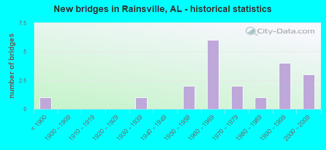
- New bridges - historical statistics
- 1Before 1900
- 11930-1939
- 21950-1959
- 61960-1969
- 21970-1979
- 11980-1989
- 41990-1999
- 32000-2009

- Reconstructed bridges - Historical Statistics
- 11970-1979
- 11980-1989


- Bridge Condition - Deck
- 30.0%Very good
- 30.0%Good
- 40.0%Satisfactory

- Bridge Condition - Superstructure
- 20.0%Very good
- 20.0%Good
- 50.0%Satisfactory
- 10.0%Poor

- Bridge Condition - Substructure
- 20.0%Very good
- 40.0%Good
- 20.0%Satisfactory
- 20.0%Fair

- Bridge Condition - Channel
- 10.0%Very good
- 45.0%Good
- 40.0%Satisfactory
- 5.0%Fair

- Bridge Condition - Culverts
- 20.0%Very good
- 60.0%Good
- 20.0%Satisfactory
Find on map >> Show street view
Structure Number: 4938, Location: EAST OF CR 578 (Lat: 34.484619, Lng: -85.906778), Route carried "on" structure: County highway 92, Year Built: 1954, Status: Open, Structure Length: 0.96m (3.15ft), Average Daily Traffic: 758 (year 2020), Truck Traffic: 5%, Average Future Daily Traffic: 1,127 (year 2040), Design Load: H 15, Features Intersected: PINEY CREEK
Minimum Vertical Clearance: 30+ m (98+ ft), Kilometerpoint: 0.010, Lanes on structure: 2, Owner: County Highway Agency, Approaching Roadway Width: 7.6m (24.9ft), Material/Design: Concrete, Design/Construction: Culvert, Number Of Spans In Main Unit: 3, Length of Maximum Span: 3.0m (9.8ft)
Condition: Channel: Satisfactory, Culverts: Satisfactory, Operating Rating: 85.6 metric tons, Method Used To Determine Operating Rating: Load Factor (LF), Inventory Rating: 51.3 metric tons, Method Used To Determine Inventory Rating: Load Factor (LF), Structural Evaluation: Equal to present minimum criteria, Waterway Adequacy: Better than present minimum criteria, Approach Roadway Alignment: Equal to present desirable criteria, Length Of Structure Improvement: 1.63m (5.35ft), Designated Inspection Frequency: Every 24 months, Inspection Date: October 2020, Bridge Improvement Cost: $338,000, Roadway Improvement Cost: $34,000, Total Project Cost: $372,000 ( Estimate for 2022)
Find on map >> Show street view
Structure Number: 4939, Location: .5 MI W OF AL 75 (Lat: 34.479761, Lng: -85.866947), Route carried "on" structure: County highway 92, Year Built: 1954, Status: Open, Structure Length: 0.63m (2.07ft), Average Daily Traffic: 366 (year 2017), Truck Traffic: 15%, Average Future Daily Traffic: 539 (year 2036), Design Load: H 15, Features Intersected: PINEY CREEK
Minimum Vertical Clearance: 30+ m (98+ ft), Kilometerpoint: 0.010, Lanes on structure: 2, Owner: City or Municipal Highway Agency, Approaching Roadway Width: 7.3m (24.0ft), Material/Design: Concrete, Design/Construction: Culvert, Number Of Spans In Main Unit: 2, Length of Maximum Span: 3.0m (9.8ft)
Condition: Channel: Satisfactory, Culverts: Good, Operating Rating: 40.9 metric tons, Method Used To Determine Operating Rating: Load Factor (LF), Inventory Rating: 24.5 metric tons, Method Used To Determine Inventory Rating: Load Factor (LF), Structural Evaluation: Equal to present minimum criteria, Waterway Adequacy: Better than present minimum criteria, Approach Roadway Alignment: Equal to present desirable criteria, Length Of Structure Improvement: 1.24m (4.07ft), Designated Inspection Frequency: Every 24 months, Inspection Date: June 2021, Bridge Improvement Cost: $230,000, Roadway Improvement Cost: $23,000, Total Project Cost: $253,000 ( Estimate for 2022)
Find on map >> Show street view
Structure Number: 8274, Location: .7 MI SW OF SR 35 (Lat: 34.508333, Lng: -85.891667), Route carried "on" structure: City street , Year Built: 1964, Status: Posted for load, Structure Length: 0.82m (2.69ft), Average Daily Traffic: 395 (year 2021), Truck Traffic: 3%, Average Future Daily Traffic: 580 (year 2040), Design Load: H 10, Features Intersected: PHILLIPS BRANCH, Facility Carried by Structure: KIRK RD
Minimum Vertical Clearance: 7.56m (24.80ft), Kilometerpoint: 0.010, Lanes on structure: 2, Owner: City or Municipal Highway Agency, Approaching Roadway Width: 9.1m (29.9ft), Material/Design: Steel, Design/Construction: Stringer/Multi-beam, Number Of Spans In Main Unit: 1, Length of Maximum Span: 8.2m (26.9ft), Curb or Sidewalk Widths: Left: 0.3m (1.0ft), Right: 0.3m (1.0ft), Curb-To-Curb Width: 6.8m (22.3ft), Out-to-Out Width: 7.4m (24.3ft)
Condition: Deck: Satisfactory, Superstructure: Satisfactory, Substructure: Good, Channel: Satisfactory, Operating Rating: 22.7 metric tons, Method Used To Determine Operating Rating: Allowable Stress (AS), Inventory Rating: 12.7 metric tons, Method Used To Determine Inventory Rating: Allowable Stress (AS), Structural Evaluation: Meets minimum limits, Deck Geometry: Meets minimum limits, Waterway Adequacy: Equal to present minimum criteria, Approach Roadway Alignment: Meets minimum limits, Bridge Posting: Required (Relationship of Operating Rating to Maximum Legal Load: > 39.9% below), Length Of Structure Improvement: 1.48m (4.86ft), Designated Inspection Frequency: Every 24 months, Other Special Inspection Frequency: Every 12 months, Inspection Date: June 2021, Other Special Inspection Date: June 2021, Bridge Improvement Cost: $243,000, Roadway Improvement Cost: $24,000, Total Project Cost: $267,000 ( Estimate for 2022), Deck Structure Type: Concrete Cast-file-Place, Wearing Surface/Protective System: Wearing Surface: Bituminous
Find on map >> Show street view
Structure Number: 8846, Location: .4 MI E AL 75 T6SR8E (Lat: 34.524944, Lng: -85.817322), Route carried "on" structure: County highway 94, Year Built: 1965, Status: Posted for load, Structure Length: 1.48m (4.86ft), Average Daily Traffic: 135 (year 2020), Truck Traffic: 4%, Average Future Daily Traffic: 240 (year 2038), Design Load: H 10, Features Intersected: CANEY CREEK, Facility Carried by Structure: CO RD 584
Minimum Vertical Clearance: 30+ m (98+ ft), Kilometerpoint: 0.010, Lanes on structure: 1, Owner: City or Municipal Highway Agency, Approaching Roadway Width: 3.7m (12.1ft), Material/Design: Steel, Design/Construction: Stringer/Multi-beam, Number Of Spans In Main Unit: 2, Length of Maximum Span: 8.5m (27.9ft), Curb-To-Curb Width: 3.4m (11.2ft), Out-to-Out Width: 3.7m (12.1ft)
Condition: Deck: Good, Superstructure: Poor, Substructure: Fair, Channel: Satisfactory, Operating Rating: 10.1 metric tons, Method Used To Determine Operating Rating: Load Factor (LF), Inventory Rating: 6.1 metric tons, Method Used To Determine Inventory Rating: Load Factor (LF), Structural Evaluation: High priority of replacement, Deck Geometry: High priority of replacement, Waterway Adequacy: Meets minimum limits, Approach Roadway Alignment: Equal to present minimum criteria, Bridge Posting: Required (Relationship of Operating Rating to Maximum Legal Load: > 39.9% below), Length Of Structure Improvement: 2.15m (7.05ft), Designated Inspection Frequency: Every 24 months, Other Special Inspection Frequency: Every 12 months, Inspection Date: Febuary 2022, Other Special Inspection Date: Febuary 2022, Bridge Improvement Cost: $177,000, Roadway Improvement Cost: $18,000, Total Project Cost: $195,000 ( Estimate for 2022), Deck Structure Type: Wood or Timber, Wearing Surface/Protective System: Wearing Surface: Wood or Timber
Find on map >> Show street view
Structure Number: 9462, Location: 1.5 MI W CO RT 87 T7SR8E (Lat: 34.424672, Lng: -85.811694), Route carried "on" structure: County highway 31A, Year Built: 1967, Status: Open, Structure Length: 0.78m (2.56ft), Average Daily Traffic: 158 (year 2021), Truck Traffic: 15%, Average Future Daily Traffic: 235 (year 2041), Design Load: H 15, Features Intersected: JACKS CREEK, Facility Carried by Structure: CO RD 461
Minimum Vertical Clearance: 30+ m (98+ ft), Kilometerpoint: 0.010, Lanes on structure: 2, Owner: County Highway Agency, Approaching Roadway Width: 8.5m (27.9ft), Skew: 1 degrees, Material/Design: Concrete, Design/Construction: Culvert, Number Of Spans In Main Unit: 2, Length of Maximum Span: 3.7m (12.1ft)
Condition: Channel: Satisfactory, Culverts: Good, Operating Rating: 58.2 metric tons, Method Used To Determine Operating Rating: Load Factor (LF), Inventory Rating: 34.8 metric tons, Method Used To Determine Inventory Rating: Load Factor (LF), Structural Evaluation: Better than present minimum criteria, Waterway Adequacy: Better than present minimum criteria, Approach Roadway Alignment: Equal to present minimum criteria, Length Of Structure Improvement: 1.43m (4.69ft), Designated Inspection Frequency: Every 24 months, Inspection Date: May 2021, Bridge Improvement Cost: $280,000, Roadway Improvement Cost: $28,000, Total Project Cost: $308,000 ( Estimate for 2022)
Find on map >> Show street view
Structure Number: 977, Location: 1.0 MI N AL 35 T6SR8E (Lat: 34.483203, Lng: -85.794231), Route carried "on" structure: County highway 90, Year Built: 1968, Status: Open, Structure Length: 0.63m (2.07ft), Average Daily Traffic: 384 (year 2021), Truck Traffic: 20%, Average Future Daily Traffic: 571 (year 2041), Design Load: H 15, Features Intersected: MORGAN CREEK
Minimum Vertical Clearance: 30+ m (98+ ft), Kilometerpoint: 0.010, Lanes on structure: 2, Owner: County Highway Agency, Approaching Roadway Width: 7.0m (23.0ft), Material/Design: Concrete, Design/Construction: Culvert, Number Of Spans In Main Unit: 2, Length of Maximum Span: 3.0m (9.8ft)
Condition: Channel: Good, Culverts: Satisfactory, Operating Rating: 65.4 metric tons, Method Used To Determine Operating Rating: Load Factor (LF), Inventory Rating: 39.3 metric tons, Method Used To Determine Inventory Rating: Load Factor (LF), Structural Evaluation: Equal to present minimum criteria, Waterway Adequacy: Better than present minimum criteria, Approach Roadway Alignment: Equal to present desirable criteria, Length Of Structure Improvement: 1.24m (4.07ft), Designated Inspection Frequency: Every 24 months, Inspection Date: May 2021, Bridge Improvement Cost: $230,000, Roadway Improvement Cost: $23,000, Total Project Cost: $253,000 ( Estimate for 2022)
Find on map >> Show street view
Structure Number: 9771, Location: 1.5 MI N AL 35 T6SR8E (Lat: 34.487181, Lng: -85.791158), Route carried "on" structure: County highway 90, Year Built: 1968, Status: Open, Structure Length: 0.88m (2.89ft), Average Daily Traffic: 199 (year 2021), Truck Traffic: 15%, Average Future Daily Traffic: 296 (year 2041), Design Load: H 15, Features Intersected: SHANKLE BRANCH
Minimum Vertical Clearance: 30+ m (98+ ft), Kilometerpoint: 0.010, Lanes on structure: 2, Owner: County Highway Agency, Approaching Roadway Width: 7.6m (24.9ft), Skew: 4 degrees, Material/Design: Concrete, Design/Construction: Culvert, Number Of Spans In Main Unit: 2, Length of Maximum Span: 3.0m (9.8ft)
Condition: Channel: Good, Culverts: Good, Operating Rating: 38.8 metric tons, Method Used To Determine Operating Rating: Load Factor (LF), Inventory Rating: 23.2 metric tons, Method Used To Determine Inventory Rating: Load Factor (LF), Structural Evaluation: Equal to present minimum criteria, Waterway Adequacy: Better than present minimum criteria, Approach Roadway Alignment: Equal to present desirable criteria, Length Of Structure Improvement: 1.55m (5.09ft), Designated Inspection Frequency: Every 24 months, Inspection Date: May 2021, Bridge Improvement Cost: $394,000, Roadway Improvement Cost: $39,000, Total Project Cost: $433,000 ( Estimate for 2022)
Find on map >> Show street view
Structure Number: 9774, Location: .25 MI E CO RT 90 T6SR8E (Lat: 34.481081, Lng: -85.793961), Route carried "on" structure: County highway 95, Year Built: 1968, Status: Open, Structure Length: 0.63m (2.07ft), Average Daily Traffic: 392 (year 2021), Truck Traffic: 5%, Average Future Daily Traffic: 583 (year 2041), Design Load: H 15, Features Intersected: MORGAN CREEK, Facility Carried by Structure: CO RD 505
Minimum Vertical Clearance: 30+ m (98+ ft), Kilometerpoint: 0.010, Lanes on structure: 2, Owner: County Highway Agency, Approaching Roadway Width: 7.9m (25.9ft), Material/Design: Concrete, Design/Construction: Culvert, Number Of Spans In Main Unit: 2, Length of Maximum Span: 3.0m (9.8ft)
Condition: Channel: Satisfactory, Culverts: Good, Operating Rating: 42.0 metric tons, Method Used To Determine Operating Rating: Load Factor (LF), Inventory Rating: 25.2 metric tons, Method Used To Determine Inventory Rating: Load Factor (LF), Structural Evaluation: Equal to present minimum criteria, Waterway Adequacy: Equal to present minimum criteria, Approach Roadway Alignment: Equal to present minimum criteria, Length Of Structure Improvement: 1.24m (4.07ft), Designated Inspection Frequency: Every 24 months, Inspection Date: July 2021, Bridge Improvement Cost: $230,000, Roadway Improvement Cost: $23,000, Total Project Cost: $253,000 ( Estimate for 2022)
Find on map >> Show street view
Structure Number: 10319, Location: BETWEEN 1ST AV*MALCON AVE (Lat: 34.488300, Lng: -85.855000), Route carried "on" structure: City street , Year Built: 1970, Status: Open, Structure Length: 0.73m (2.40ft), Average Daily Traffic: 140 (year 2021), Truck Traffic: 2%, Average Future Daily Traffic: 240 (year 2042), Design Load: H 20, Features Intersected: PINEY CREEK, Facility Carried by Structure: GEORGE WALLACE DR
Minimum Vertical Clearance: 7.56m (24.80ft), Kilometerpoint: 0.010, Lanes on structure: 2, Owner: City or Municipal Highway Agency, Approaching Roadway Width: 7.9m (25.9ft), Material/Design: Concrete, Design/Construction: Channel Beam, Number Of Spans In Main Unit: 1, Length of Maximum Span: 7.3m (24.0ft), Curb or Sidewalk Widths: Left: 0.2m (0.7ft), Right: 0.2m (0.7ft), Curb-To-Curb Width: 7.3m (24.0ft), Out-to-Out Width: 7.7m (25.3ft)
Condition: Deck: Good, Superstructure: Good, Substructure: Satisfactory, Channel: Good, Operating Rating: 70.7 metric tons, Method Used To Determine Operating Rating: Allowable Stress (AS), Inventory Rating: 46.2 metric tons, Method Used To Determine Inventory Rating: Allowable Stress (AS), Structural Evaluation: Equal to present minimum criteria, Deck Geometry: Somewhat better than minimum adequacy, Waterway Adequacy: Better than present minimum criteria, Approach Roadway Alignment: High priority of corrective action, Length Of Structure Improvement: 1.38m (4.53ft), Designated Inspection Frequency: Every 24 months, Inspection Date: March 2021, Bridge Improvement Cost: $236,000, Roadway Improvement Cost: $24,000, Total Project Cost: $260,000 ( Estimate for 2022), Deck Structure Type: Concrete Precast Panels, Wearing Surface/Protective System: Wearing Surface: Bituminous
Find on map >> Show street view
Structure Number: 10609, Location: 2.0 MI NE AL 35 T6SR8E (Lat: 34.499475, Lng: -85.806278), Route carried "on" structure: County highway 93, Year Built: 1971, Status: Open, Structure Length: 1.31m (4.30ft), Average Daily Traffic: 916 (year 2021), Average Future Daily Traffic: 1,361 (year 2041), Design Load: H 15, Features Intersected: CANEY CREEK, Facility Carried by Structure: CO RT 180
Minimum Vertical Clearance: 30+ m (98+ ft), Kilometerpoint: 0.010, Lanes on structure: 2, Owner: County Highway Agency, Approaching Roadway Width: 7.6m (24.9ft), Material/Design: Concrete, Design/Construction: Channel Beam, Number Of Spans In Main Unit: 2, Length of Maximum Span: 7.3m (24.0ft), Curb-To-Curb Width: 7.3m (24.0ft), Out-to-Out Width: 7.6m (24.9ft)
Condition: Deck: Satisfactory, Superstructure: Satisfactory, Substructure: Fair, Channel: Fair, Operating Rating: 69.7 metric tons, Method Used To Determine Operating Rating: Allowable Stress (AS), Inventory Rating: 44.9 metric tons, Method Used To Determine Inventory Rating: Allowable Stress (AS), Structural Evaluation: Somewhat better than minimum adequacy, Deck Geometry: Meets minimum limits, Waterway Adequacy: Better than present minimum criteria, Approach Roadway Alignment: Equal to present minimum criteria, Length Of Structure Improvement: 1.98m (6.50ft), Designated Inspection Frequency: Every 24 months, Inspection Date: July 2021, Bridge Improvement Cost: $340,000, Roadway Improvement Cost: $34,000, Total Project Cost: $374,000 ( Estimate for 2022), Deck Structure Type: Concrete Precast Panels, Wearing Surface/Protective System: Wearing Surface: Bituminous
Find on map >> Show street view
Structure Number: 13452, Location: BETWEEN MARSHALL RD* SR75 (Lat: 34.500000, Lng: -85.833333), Route carried "on" structure: City street , Year Built: 1931, Year Reconstructed: 1985, Status: Posted for load, Structure Length: 0.82m (2.69ft), Average Daily Traffic: 430 (year 2017), Truck Traffic: 4%, Average Future Daily Traffic: 500 (year 2035), Design Load: H 10, Features Intersected: IVY CREEK, Facility Carried by Structure: DILBECK RD
Minimum Vertical Clearance: 7.56m (24.80ft), Kilometerpoint: 0.010, Lanes on structure: 2, Owner: City or Municipal Highway Agency, Approaching Roadway Width: 7.6m (24.9ft), Skew: 2 degrees, Material/Design: Steel, Design/Construction: Stringer/Multi-beam, Number Of Spans In Main Unit: 1, Length of Maximum Span: 8.2m (26.9ft), Curb-To-Curb Width: 6.5m (21.3ft), Out-to-Out Width: 6.8m (22.3ft)
Condition: Deck: Satisfactory, Superstructure: Satisfactory, Substructure: Good, Channel: Satisfactory, Operating Rating: 10.0 metric tons, Method Used To Determine Operating Rating: Allowable Stress (AS), Inventory Rating: 3.6 metric tons, Method Used To Determine Inventory Rating: Allowable Stress (AS), Structural Evaluation: High priority of replacement, Deck Geometry: High priority of corrective action, Waterway Adequacy: Equal to present minimum criteria, Approach Roadway Alignment: Meets minimum limits, Bridge Posting: Required (Relationship of Operating Rating to Maximum Legal Load: > 39.9% below), Length Of Structure Improvement: 1.48m (4.86ft), Designated Inspection Frequency: Every 24 months, Other Special Inspection Frequency: Every 12 months, Inspection Date: Febuary 2022, Other Special Inspection Date: Febuary 2022, Bridge Improvement Cost: $223,000, Roadway Improvement Cost: $22,000, Total Project Cost: $245,000 ( Estimate for 2022), Deck Structure Type: Concrete Cast-file-Place
Find on map >> Show street view
Structure Number: 13625, Location: BETWEEN PARKER AVE SCOTT (Lat: 34.479419, Lng: -85.837383), Route carried "on" structure: City street , Year Built: 1985, Status: Open, Structure Length: 1.16m (3.81ft), Average Daily Traffic: 275 (year 2021), Truck Traffic: 1%, Average Future Daily Traffic: 335 (year 2036), Design Load: HS 20, Features Intersected: IVY CREEK, Facility Carried by Structure: EVERETT ST SW
Minimum Vertical Clearance: 7.56m (24.80ft), Kilometerpoint: 0.010, Lanes on structure: 2, Owner: City or Municipal Highway Agency, Approaching Roadway Width: 12.2m (40.0ft), Skew: 1 degrees, Material/Design: Concrete, Design/Construction: Culvert, Number Of Spans In Main Unit: 3, Length of Maximum Span: 3.7m (12.1ft)
Condition: Channel: Satisfactory, Culverts: Good, Operating Rating: 79.3 metric tons, Method Used To Determine Operating Rating: Load Factor (LF), Inventory Rating: 47.6 metric tons, Method Used To Determine Inventory Rating: Load Factor (LF), Structural Evaluation: Better than present minimum criteria, Waterway Adequacy: Equal to present minimum criteria, Approach Roadway Alignment: Better than present minimum criteria, Length Of Structure Improvement: 1.84m (6.04ft), Designated Inspection Frequency: Every 24 months, Inspection Date: June 2021, Bridge Improvement Cost: $509,000, Roadway Improvement Cost: $51,000, Total Project Cost: $560,000 ( Estimate for 2022), Wearing Surface/Protective System: Wearing Surface: Bituminous
Find on map >> Show street view
Structure Number: 1516, Location: 0.3 MI S OF HORTON RD (Lat: 34.478400, Lng: -85.873200), Route carried "on" structure: City street , Year Built: 1990, Status: Open, Structure Length: 0.94m (3.08ft), Average Daily Traffic: 225 (year 2021), Truck Traffic: 1%, Average Future Daily Traffic: 280 (year 2039), Design Load: HS 20, Features Intersected: PINEY CREEK, Facility Carried by Structure: RAY AVE
Minimum Vertical Clearance: 7.56m (24.80ft), Kilometerpoint: 0.010, Lanes on structure: 2, Owner: City or Municipal Highway Agency, Approaching Roadway Width: 6.1m (20.0ft), Skew: 3 degrees, Material/Design: Concrete, Design/Construction: Channel Beam, Number Of Spans In Main Unit: 1, Length of Maximum Span: 9.4m (30.8ft), Curb-To-Curb Width: 3.6m (11.8ft), Out-to-Out Width: 7.1m (23.3ft)
Condition: Deck: Very good, Superstructure: Very good, Substructure: Good, Channel: Very good, Operating Rating: 64.8 metric tons, Method Used To Determine Operating Rating: Load Factor (LF), Inventory Rating: 33.7 metric tons, Method Used To Determine Inventory Rating: Load Factor (LF), Structural Evaluation: Better than present minimum criteria, Deck Geometry: High priority of replacement, Waterway Adequacy: Equal to present desirable criteria, Approach Roadway Alignment: Equal to present minimum criteria, Length Of Structure Improvement: 1.61m (5.28ft), Designated Inspection Frequency: Every 24 months, Inspection Date: Febuary 2021, Bridge Improvement Cost: $254,000, Roadway Improvement Cost: $25,000, Total Project Cost: $279,000 ( Estimate for 2022), Deck Structure Type: Concrete Precast Panels
Find on map >> Show street view
Structure Number: 16737, Location: S CITY OF RAINSVILLE (Lat: 34.477822, Lng: -85.809036), Route carried "on" structure: State highway 35, Year Built: 1997, Status: Open, Structure Length: 7.93m (26.02ft), Average Daily Traffic: 9,560 (year 2019), Truck Traffic: 6%, Average Future Daily Traffic: 13,384 (year 2039), Design Load: HS 20, Features Intersected: TOWN CREEK
Minimum Vertical Clearance: 30+ m (98+ ft), Kilometerpoint: 47.128, Lanes on structure: 2, Base Highway Network: Yes, Owner: State Highway Agency, Approaching Roadway Width: 13.1m (43.0ft), Skew: 14 degrees, Material/Design: Prestressed concrete, Design/Construction: Stringer/Multi-beam, Number Of Spans In Main Unit: 1, Number Of Approach Spans: 2, Length of Maximum Span: 36.6m (120.1ft), Curb-To-Curb Width: 12.2m (40.0ft), Out-to-Out Width: 13.1m (43.0ft)
Condition: Deck: Very good, Superstructure: Good, Substructure: Very good, Channel: Good, Operating Rating: 62.7 metric tons, Method Used To Determine Operating Rating: Load Factor (LF), Inventory Rating: 37.6 metric tons, Method Used To Determine Inventory Rating: Load Factor (LF), Structural Evaluation: Better than present minimum criteria, Deck Geometry: Better than present minimum criteria, Waterway Adequacy: Equal to present minimum criteria, Approach Roadway Alignment: Equal to present desirable criteria, Length Of Structure Improvement: 8.94m (29.33ft), Designated Inspection Frequency: Every 24 months, Inspection Date: April 2021, Bridge Improvement Cost: $2,635,000, Roadway Improvement Cost: $264,000, Total Project Cost: $2,899,000 ( Estimate for 2022), Deck Structure Type: Concrete Cast-file-Place
Find on map >> Show street view
Structure Number: 16738, Location: S CITY OF RAINSVILLE (Lat: 34.477589, Lng: -85.809064), Route carried "on" structure: State highway 35, Year Built: 1995, Status: Open, Structure Length: 7.92m (25.98ft), Average Daily Traffic: 9,560 (year 2019), Truck Traffic: 6%, Average Future Daily Traffic: 13,384 (year 2039), Design Load: HS 20, Features Intersected: TOWN CREEK
Minimum Vertical Clearance: 30+ m (98+ ft), Kilometerpoint: 47.128, Lanes on structure: 2, Base Highway Network: Yes, Owner: State Highway Agency, Approaching Roadway Width: 13.1m (43.0ft), Skew: 14 degrees, Material/Design: Prestressed concrete, Design/Construction: Tee Beam, Number Of Spans In Main Unit: 1, Number Of Approach Spans: 2, Length of Maximum Span: 36.6m (120.1ft), Curb-To-Curb Width: 12.2m (40.0ft), Out-to-Out Width: 13.1m (43.0ft)
Condition: Deck: Satisfactory, Superstructure: Satisfactory, Substructure: Good, Channel: Good, Operating Rating: 73.8 metric tons, Method Used To Determine Operating Rating: Load Factor (LF), Inventory Rating: 45.3 metric tons, Method Used To Determine Inventory Rating: Load Factor (LF), Structural Evaluation: Equal to present minimum criteria, Deck Geometry: Better than present minimum criteria, Waterway Adequacy: Equal to present minimum criteria, Approach Roadway Alignment: Equal to present desirable criteria, Length Of Structure Improvement: 8.93m (29.30ft), Designated Inspection Frequency: Every 24 months, Inspection Date: April 2021, Bridge Improvement Cost: $2,632,000, Roadway Improvement Cost: $263,000, Total Project Cost: $2,895,000 ( Estimate for 2022), Deck Structure Type: Concrete Cast-file-Place
Find on map >> Show street view
Structure Number: 16741, Location: IN CITY OF RAINSVILLE (Lat: 34.486639, Lng: -85.829500), Route carried "on" structure: State highway 35, Year Built: 1996, Status: Open, Structure Length: 0.94m (3.08ft), Average Daily Traffic: 17,577 (year 2019), Truck Traffic: 7%, Average Future Daily Traffic: 24,608 (year 2039), Design Load: HS 20, Features Intersected: IVY CREEK
Minimum Vertical Clearance: 30+ m (98+ ft), Kilometerpoint: 49.236, Lanes on structure: 5, Owner: State Highway Agency, Approaching Roadway Width: 18.3m (60.0ft), Material/Design: Concrete, Design/Construction: Culvert, Number Of Spans In Main Unit: 3, Length of Maximum Span: 3.0m (9.8ft)
Condition: Channel: Good, Culverts: Good, Operating Rating: 88.9 metric tons, Method Used To Determine Operating Rating: Load Factor (LF), Inventory Rating: 88.9 metric tons, Method Used To Determine Inventory Rating: Load Factor (LF), Structural Evaluation: Better than present minimum criteria, Waterway Adequacy: Equal to present desirable criteria, Approach Roadway Alignment: Equal to present desirable criteria, Length Of Structure Improvement: 1.61m (5.28ft), Designated Inspection Frequency: Every 24 months, Inspection Date: October 2020, Bridge Improvement Cost: $1,560,000, Roadway Improvement Cost: $156,000, Total Project Cost: $1,716,000 ( Estimate for 2022), Wearing Surface/Protective System: Wearing Surface: Bituminous
Find on map >> Show street view
Structure Number: 19009, Location: 0.5 MILE S OF SR 35 (Lat: 34.474147, Lng: -85.814203), Route carried "on" structure: City street , Year Built: 1898, Year Reconstructed: 1981, Status: Closed, Structure Length: 8.13m (26.67ft), Average Daily Traffic: 615 (year 2017), Truck Traffic: 2%, Average Future Daily Traffic: 840 (year 2035), Design Load: H 10, Features Intersected: TOWN CREEK, Facility Carried by Structure: CHAVIES ROAD
Minimum Vertical Clearance: 30+ m (98+ ft), Kilometerpoint: 0.000, Lanes on structure: 1, Owner: City or Municipal Highway Agency, Approaching Roadway Width: 7.3m (24.0ft), Material/Design: Concrete, Design/Construction: Channel Beam, Number Of Spans In Main Unit: 3, Number Of Approach Spans: 2, Length of Maximum Span: 33.3m (109.3ft), Curb or Sidewalk Widths: Left: 0.2m (0.7ft), Right: 0.2m (0.7ft), Curb-To-Curb Width: 3.9m (12.8ft), Out-to-Out Width: 4.4m (14.4ft)
Condition: Deck: Good, Superstructure: Satisfactory, Substructure: Satisfactory, Channel: Good, Operating Rating: 17.3 metric tons, Method Used To Determine Operating Rating: Allowable Stress (AS), Inventory Rating: 11.9 metric tons, Method Used To Determine Inventory Rating: Allowable Stress (AS), Waterway Adequacy: Superior to present desirable criteria, Approach Roadway Alignment: Better than present minimum criteria, Bridge Posting: Required (Relationship of Operating Rating to Maximum Legal Load: > 39.9% below), Length Of Structure Improvement: 9.13m (29.95ft), Designated Inspection Frequency: Every 24 months, Other Special Inspection Frequency: Every 12 months, Inspection Date: November 2018, Other Special Inspection Date: November 2018, Bridge Improvement Cost: $876,000, Roadway Improvement Cost: $88,000, Total Project Cost: $964,000 ( Estimate for 2022), Deck Structure Type: Concrete Precast Panels
Find on map >> Show street view
Structure Number: 1948, Location: T-6-S, R-7-E, SEC. 12 (Lat: 34.527967, Lng: -85.864397), Route carried "on" structure: County highway 201, Year Built: 2005, Status: Open, Structure Length: 2.01m (6.59ft), Average Daily Traffic: 237 (year 2019), Truck Traffic: 7%, Average Future Daily Traffic: 352 (year 2039), Design Load: HS 20, Features Intersected: SOUTH SAUTY CREEK, Facility Carried by Structure: COUNTY ROAD 577
Minimum Vertical Clearance: 30+ m (98+ ft), Kilometerpoint: 0.010, Lanes on structure: 2, Owner: County Highway Agency, Approaching Roadway Width: 10.7m (35.1ft), Material/Design: Concrete, Design/Construction: Culvert, Number Of Spans In Main Unit: 4, Length of Maximum Span: 4.9m (16.1ft)
Condition: Channel: Good, Culverts: Very good, Operating Rating: 88.9 metric tons, Method Used To Determine Operating Rating: Load Factor (LF), Inventory Rating: 88.9 metric tons, Method Used To Determine Inventory Rating: Load Factor (LF), Structural Evaluation: Equal to present desirable criteria, Waterway Adequacy: Superior to present desirable criteria, Approach Roadway Alignment: Equal to present desirable criteria, Length Of Structure Improvement: 2.76m (9.06ft), Designated Inspection Frequency: Every 24 months, Inspection Date: March 2021, Bridge Improvement Cost: $1,772,000, Roadway Improvement Cost: $177,000, Total Project Cost: $1,949,000 ( Estimate for 2022)
Find on map >> Show street view
Structure Number: 19721, Location: T6S,R8E, SECTIONS 16 * 21 (Lat: 34.506717, Lng: -85.810653), Route carried "on" structure: County highway 515, Year Built: 2006, Status: Open, Structure Length: 1.22m (4.00ft), Average Daily Traffic: 54 (year 2020), Truck Traffic: 3%, Average Future Daily Traffic: 80 (year 2040), Design Load: HS 20, Features Intersected: CANEY CREEK
Minimum Vertical Clearance: 30+ m (98+ ft), Kilometerpoint: 0.000, Lanes on structure: 2, Owner: County Highway Agency, Approaching Roadway Width: 8.5m (27.9ft), Material/Design: Concrete, Design/Construction: Channel Beam, Number Of Spans In Main Unit: 1, Length of Maximum Span: 12.2m (40.0ft), Curb-To-Curb Width: 8.5m (27.9ft), Out-to-Out Width: 9.3m (30.5ft)
Condition: Deck: Very good, Superstructure: Very good, Substructure: Very good, Channel: Good, Operating Rating: 74.7 metric tons, Method Used To Determine Operating Rating: Load Factor (LF), Inventory Rating: 44.8 metric tons, Method Used To Determine Inventory Rating: Load Factor (LF), Structural Evaluation: Equal to present desirable criteria, Deck Geometry: Better than present minimum criteria, Waterway Adequacy: Better than present minimum criteria, Approach Roadway Alignment: Equal to present minimum criteria, Length Of Structure Improvement: 1.89m (6.20ft), Designated Inspection Frequency: Every 24 months, Inspection Date: May 2020, Bridge Improvement Cost: $389,000, Roadway Improvement Cost: $39,000, Total Project Cost: $428,000 ( Estimate for 2022), Deck Structure Type: Concrete Precast Panels
Find on map >> Show street view
Structure Number: 19946, Location: T6S, R7E, SEC. 12 (Lat: 34.529514, Lng: -85.856211), Route carried "on" structure: County highway 575, Year Built: 2007, Status: Open, Structure Length: 1.24m (4.07ft), Average Daily Traffic: 77 (year 2021), Average Future Daily Traffic: 14 (year 2041), Design Load: HS 20, Features Intersected: BIG BRANCH
Minimum Vertical Clearance: 30+ m (98+ ft), Kilometerpoint: 0.000, Lanes on structure: 2, Owner: County Highway Agency, Approaching Roadway Width: 7.0m (23.0ft), Skew: 1 degrees, Material/Design: Steel, Design/Construction: Culvert, Number Of Spans In Main Unit: 4, Length of Maximum Span: 2.4m (7.9ft)
Condition: Channel: Very good, Culverts: Very good, Operating Rating: 88.9 metric tons, Method Used To Determine Operating Rating: Load Factor (LF), Inventory Rating: 88.9 metric tons, Method Used To Determine Inventory Rating: Load Factor (LF), Structural Evaluation: Equal to present desirable criteria, Waterway Adequacy: Equal to present desirable criteria, Approach Roadway Alignment: Equal to present desirable criteria, Length Of Structure Improvement: 1.92m (6.30ft), Designated Inspection Frequency: Every 24 months, Inspection Date: September 2021, Bridge Improvement Cost: $443,000, Roadway Improvement Cost: $44,000, Total Project Cost: $487,000 ( Estimate for 2022)