Bridge Statistics for Ramblewood, New Jersey (NJ)
Condition, Traffic, Stress, Structural Evaluation, Project Costs
- National Bridge Inventory (NBI) Statistics
- 27Number of bridges
- 174ft / 53.4mTotal length
- $2,570,000Total costs
- 1,276,574Total average daily traffic
- 125,619Total average daily truck traffic
- National Bridge Inventory (NBI) Registered Bridges for Ramblewood
- No street view available for this location
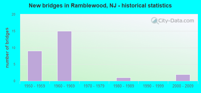
- New bridges - historical statistics
- 91950-1959
- 151960-1969
- 11980-1989
- 22000-2009

- Reconstructed bridges - Historical Statistics
- 11970-1979
- 01980-1989
- 41990-1999
- 12000-2009


- Bridge Condition - Deck
- 61.5%Good
- 30.8%Satisfactory
- 7.7%Fair

- Bridge Condition - Superstructure
- 15.4%Very good
- 38.5%Good
- 38.5%Satisfactory
- 7.7%Fair

- Bridge Condition - Substructure
- 7.7%Very good
- 61.5%Good
- 30.8%Satisfactory

- Bridge Condition - Channel
- 20.0%Good
- 60.0%Satisfactory
- 20.0%Fair
Find on map >> Show street view
Structure Number: 31415, Location: 0.9 MI SOUTH OF RT38 INT (Lat: 39.934719, Lng: -74.965511), Route carried "on" structure: State highway 73, Year Built: 1963, Status: Open, Structure Length: 5.33m (17.49ft), Average Daily Traffic: 71,851 (year 2020), Truck Traffic: 4%, Average Future Daily Traffic: 87,673 (year 2040), Design Load: HS 20, Features Intersected: ROUTE I-295
Minimum Vertical Clearance: 30+ m (98+ ft), Kilometerpoint: 44.531, Lanes on structure: 6, Lanes under structure: 8, Base Highway Network: Yes, Owner: State Highway Agency, Approaching Roadway Width: 30.3m (99.4ft), Skew: 31 degrees, Material/Design: Prestressed concrete, Design/Construction: Stringer/Multi-beam, Number Of Spans In Main Unit: 2, Length of Maximum Span: 26.5m (86.9ft), Curb or Sidewalk Widths: Left: 1.8m (5.9ft), Right: 1.8m (5.9ft), Curb-To-Curb Width: 30.3m (99.4ft), Out-to-Out Width: 35.4m (116.1ft)
Condition: Deck: Good, Superstructure: Satisfactory, Substructure: Good, Structural Evaluation: Equal to present minimum criteria, Deck Geometry: Superior to present desirable criteria, Underclear: Meets minimum limits, Approach Roadway Alignment: Equal to present desirable criteria, Designated Inspection Frequency: Every 24 months, Inspection Date: September 2020, Deck Structure Type: Concrete Cast-file-Place, Wearing Surface/Protective System: Wearing Surface: Latex Concrete
Find on map >> Show street view
Structure Number: 32715, Location: 0.55 MI S OF NJ 73 (Lat: 39.928950, Lng: -74.972831), Route carried "on" structure: Interstate 295, Year Built: 1963, Year Reconstructed: 2003, Status: Open, Structure Length: 1.98m (6.50ft), Average Daily Traffic: 67,757 (year 2021), Truck Traffic: 9%, Average Future Daily Traffic: 82,676 (year 2041), Design Load: HS 25 or greater, Features Intersected: CHURCH RD (CR 616)
Minimum Vertical Clearance: 30+ m (98+ ft), Kilometerpoint: 58.435, Lanes on structure: 3, Lanes under structure: 2, Base Highway Network: Yes, Owner: State Highway Agency, Approaching Roadway Width: 18.9m (62.0ft), Skew: 1 degrees, Material/Design: Prestressed concrete, Design/Construction: Stringer/Multi-beam, Number Of Spans In Main Unit: 1, Length of Maximum Span: 19.2m (63.0ft), Curb-To-Curb Width: 18.9m (62.0ft), Out-to-Out Width: 21.3m (69.9ft)
Condition: Deck: Good, Superstructure: Good, Substructure: Good, Operating Rating: 55.3 metric tons, Method Used To Determine Operating Rating: Load Factor (LF), Inventory Rating: 32.7 metric tons, Method Used To Determine Inventory Rating: Load Factor (LF), Structural Evaluation: Better than present minimum criteria, Deck Geometry: Superior to present desirable criteria, Underclear: Equal to present minimum criteria, Approach Roadway Alignment: Equal to present desirable criteria, Designated Inspection Frequency: Every 24 months, Inspection Date: July 2021, Deck Structure Type: Concrete Cast-file-Place, Wearing Surface/Protective System: Wearing Surface: Monolithic Concrete
Find on map >> Show street view
Structure Number: 327151, Location: 1.7 MI NORTH OF RT 70 (Lat: 39.928331, Lng: -74.973331), Route carried "on" structure: Interstate 295, Year Built: 1963, Year Reconstructed: 2003, Status: Open, Structure Length: 2.13m (6.99ft), Average Daily Traffic: 53,106 (year 2020), Truck Traffic: 9%, Average Future Daily Traffic: 64,800 (year 2040), Design Load: HL 93, Features Intersected: CHURCH ROAD (CO.RT.616)
Minimum Vertical Clearance: 30+ m (98+ ft), Kilometerpoint: 58.435, Lanes on structure: 3, Lanes under structure: 2, Base Highway Network: Yes, Owner: State Highway Agency, Approaching Roadway Width: 18.9m (62.0ft), Skew: 1 degrees, Material/Design: Steel, Design/Construction: Stringer/Multi-beam, Number Of Spans In Main Unit: 1, Length of Maximum Span: 19.5m (64.0ft), Curb-To-Curb Width: 18.9m (62.0ft), Out-to-Out Width: 19.9m (65.3ft)
Condition: Deck: Satisfactory, Superstructure: Very good, Substructure: Good, Operating Rating: 54.4 metric tons, Method Used To Determine Operating Rating: Load and Resistance Factor Rating (LRFR) rating reported by rating factor(RF) method using HL-93 loadings, Inventory Rating: 52.5 metric tons, Method Used To Determine Inventory Rating: Load and Resistance Factor Rating (LRFR) rating reported by rating factor(RF) method using HL-93 loadings, Structural Evaluation: Better than present minimum criteria, Deck Geometry: Superior to present desirable criteria, Underclear: Equal to present minimum criteria, Approach Roadway Alignment: Equal to present desirable criteria, Designated Inspection Frequency: Every 24 months, Inspection Date: July 2020, Deck Structure Type: Concrete Cast-file-Place, Wearing Surface/Protective System: Wearing Surface: Monolithic Concrete, Deck Protection: Epoxy Coated Reinforcing
Find on map >> Show street view
Structure Number: 327153, Location: 2.9 MI NORTH OF RT 70 (Lat: 39.940000, Lng: -74.954869), Route carried "on" structure: County highway 673, Year Built: 1966, Year Reconstructed: 1979, Status: Open, Structure Length: 8.08m (26.51ft), Average Daily Traffic: 22,572 (year 2021), Truck Traffic: 4%, Average Future Daily Traffic: 27,086 (year 2041), Design Load: HS 20+Mod, Features Intersected: I-295, Facility Carried by Structure: FELLOWSHIP ROAD
Minimum Vertical Clearance: 30+ m (98+ ft), Kilometerpoint: 2.639, Lanes on structure: 4, Lanes under structure: 6, Owner: State Highway Agency, Approaching Roadway Width: 15.2m (49.9ft), Skew: 4 degrees, Material/Design: Steel, Design/Construction: Stringer/Multi-beam, Number Of Spans In Main Unit: 3, Length of Maximum Span: 30.5m (100.1ft), Curb or Sidewalk Widths: Left: 0.0m, Right: 1.8m (5.9ft), Curb-To-Curb Width: 15.2m (49.9ft), Out-to-Out Width: 18.0m (59.1ft)
Condition: Deck: Good, Superstructure: Satisfactory, Substructure: Good, Operating Rating: 72.6 metric tons, Method Used To Determine Operating Rating: Load Factor (LF), Inventory Rating: 43.5 metric tons, Method Used To Determine Inventory Rating: Load Factor (LF), Structural Evaluation: Equal to present minimum criteria, Deck Geometry: High priority of corrective action, Underclear: High priority of corrective action, Approach Roadway Alignment: Better than present minimum criteria, Length Of Structure Improvement: 8.08m (26.51ft), Designated Inspection Frequency: Every 24 months, Inspection Date: May 2021, Bridge Improvement Cost: $1,125,000, Roadway Improvement Cost: $212,000, Total Project Cost: $1,450,000 ( Estimate for 2021), Deck Structure Type: Concrete Cast-file-Place, Wearing Surface/Protective System: Wearing Surface: Bituminous
Find on map >> Show street view
Structure Number: 327154, Location: 0.1 MI WEST OF I-295 (Lat: 39.941200, Lng: -74.954100), Route carried "on" structure: County highway 673, Year Built: 1965, Status: Open, Structure Length: 0.82m (2.69ft), Average Daily Traffic: 8,033 (year 2020), Truck Traffic: 4%, Average Future Daily Traffic: 9,802 (year 2040), Design Load: HS 20+Mod, Features Intersected: N BR PENNSAUKEN CREEK
Minimum Vertical Clearance: 30+ m (98+ ft), Kilometerpoint: 2.800, Lanes on structure: 3, Owner: State Highway Agency, Approaching Roadway Width: 13.4m (44.0ft), Skew: 2 degrees, Material/Design: Concrete, Design/Construction: Culvert, Number Of Spans In Main Unit: 1, Length of Maximum Span: 7.6m (24.9ft)
Condition: Channel: Satisfactory, Culverts: Satisfactory, Operating Rating: 71.7 metric tons, Method Used To Determine Operating Rating: Load Factor (LF), Inventory Rating: 42.6 metric tons, Method Used To Determine Inventory Rating: Load Factor (LF), Structural Evaluation: Equal to present minimum criteria, Waterway Adequacy: Equal to present desirable criteria, Approach Roadway Alignment: Equal to present desirable criteria, Designated Inspection Frequency: Every 24 months, Inspection Date: July 2020, Bridge Improvement Cost: $4,000, Total Project Cost: $4,000 ( Estimate for 2020)
Find on map >> Show street view
Structure Number: 327155, Location: 2.8 MI SOUTH OF RT 38 (Lat: 39.940250, Lng: -74.952419), Route carried "on" structure: Interstate 295, Year Built: 1966, Status: Open, Structure Length: 1.01m (3.31ft), Average Daily Traffic: 118,720 (year 2020), Truck Traffic: 9%, Average Future Daily Traffic: 183,245 (year 2040), Design Load: HS 20, Features Intersected: N. BR. PENNSAUKEN CK
Minimum Vertical Clearance: 30+ m (98+ ft), Kilometerpoint: 60.608, Lanes on structure: 6, Base Highway Network: Yes, Owner: State Highway Agency, Approaching Roadway Width: 51.8m (169.9ft), Skew: 24 degrees, Material/Design: Concrete, Design/Construction: Culvert, Number Of Spans In Main Unit: 1, Length of Maximum Span: 10.1m (33.1ft), Out-to-Out Width: 70.9m (232.6ft)
Condition: Channel: Good, Culverts: Satisfactory, Operating Rating: 51.7 metric tons, Method Used To Determine Operating Rating: Load Factor (LF), Inventory Rating: 30.8 metric tons, Method Used To Determine Inventory Rating: Load Factor (LF), Structural Evaluation: Equal to present minimum criteria, Waterway Adequacy: Equal to present desirable criteria, Approach Roadway Alignment: Equal to present desirable criteria, Designated Inspection Frequency: Every 24 months, Inspection Date: May 2020
Find on map >> Show street view
Structure Number: 327156, Location: 2.2 MI SOUTH OF RT 38 (Lat: 39.944211, Lng: -74.940231), Route carried "on" structure: Interstate 295, Year Built: 1965, Year Reconstructed: 2003, Status: Open, Structure Length: 3.47m (11.38ft), Average Daily Traffic: 45,630 (year 2020), Truck Traffic: 9%, Average Future Daily Traffic: 54,915 (year 2040), Design Load: HL 93, Features Intersected: CHURCH STREET (CR 607)
Minimum Vertical Clearance: 30+ m (98+ ft), Kilometerpoint: 61.751, Lanes on structure: 3, Lanes under structure: 4, Base Highway Network: Yes, Owner: State Highway Agency, Approaching Roadway Width: 18.6m (61.0ft), Material/Design: Steel, Design/Construction: Stringer/Multi-beam, Number Of Spans In Main Unit: 3, Length of Maximum Span: 17.7m (58.1ft), Curb-To-Curb Width: 18.6m (61.0ft), Out-to-Out Width: 19.5m (64.0ft)
Condition: Deck: Good, Superstructure: Very good, Substructure: Very good, Operating Rating: 53.5 metric tons, Method Used To Determine Operating Rating: Load and Resistance Factor Rating (LRFR) rating reported by rating factor(RF) method using HL-93 loadings, Inventory Rating: 41.1 metric tons, Method Used To Determine Inventory Rating: Load and Resistance Factor Rating (LRFR) rating reported by rating factor(RF) method using HL-93 loadings, Structural Evaluation: Equal to present desirable criteria, Deck Geometry: Superior to present desirable criteria, Underclear: Meets minimum limits, Approach Roadway Alignment: Equal to present desirable criteria, Designated Inspection Frequency: Every 24 months, Inspection Date: May 2020, Deck Structure Type: Concrete Cast-file-Place, Wearing Surface/Protective System: Wearing Surface: Monolithic Concrete, Deck Protection: Epoxy Coated Reinforcing
Find on map >> Show street view
Structure Number: 327157, Location: 2.2 MI SOUTH OF RT 38 (Lat: 39.944500, Lng: -74.940719), Route carried "on" structure: Interstate 295, Year Built: 1965, Year Reconstructed: 2003, Status: Open, Structure Length: 3.35m (10.99ft), Average Daily Traffic: 50,998 (year 2020), Truck Traffic: 9%, Average Future Daily Traffic: 76,785 (year 2040), Design Load: HS 20, Features Intersected: CHURCH STREET (CR 607)
Minimum Vertical Clearance: 30+ m (98+ ft), Kilometerpoint: 61.751, Lanes on structure: 3, Lanes under structure: 4, Base Highway Network: Yes, Owner: State Highway Agency, Approaching Roadway Width: 17.7m (58.1ft), Material/Design: Steel, Design/Construction: Stringer/Multi-beam, Number Of Spans In Main Unit: 3, Length of Maximum Span: 17.7m (58.1ft), Curb-To-Curb Width: 17.7m (58.1ft), Out-to-Out Width: 19.2m (63.0ft)
Condition: Deck: Good, Superstructure: Good, Substructure: Good, Operating Rating: 79.8 metric tons, Method Used To Determine Operating Rating: Load Factor (LF), Inventory Rating: 47.2 metric tons, Method Used To Determine Inventory Rating: Load Factor (LF), Structural Evaluation: Better than present minimum criteria, Deck Geometry: Better than present minimum criteria, Underclear: High priority of replacement, Approach Roadway Alignment: Equal to present desirable criteria, Length Of Structure Improvement: 3.35m (10.99ft), Designated Inspection Frequency: Every 24 months, Inspection Date: April 2020, Bridge Improvement Cost: $24,000, Total Project Cost: $32,000 ( Estimate for 2018), Deck Structure Type: Concrete Cast-file-Place, Wearing Surface/Protective System: Wearing Surface: Monolithic Concrete, Deck Protection: Epoxy Coated Reinforcing
Find on map >> Show street view
Structure Number: 3B4102, Location: 1.22 MI N OF CR 616 (Lat: 39.932381, Lng: -74.933781), Route carried "on" structure: County highway 607, Year Built: 1969, Status: Open, Structure Length: 0.91m (2.99ft), Average Daily Traffic: 14,436 (year 2021), Truck Traffic: 4%, Average Future Daily Traffic: 17,323 (year 2041), Design Load: HS 20, Features Intersected: N.BR.PENNSAUKEN CREEK
Minimum Vertical Clearance: 30+ m (98+ ft), Kilometerpoint: 5.488, Lanes on structure: 4, Owner: County Highway Agency, Approaching Roadway Width: 14.0m (45.9ft), Material/Design: Prestressed concrete, Design/Construction: Slab, Number Of Spans In Main Unit: 1, Length of Maximum Span: 8.8m (28.9ft), Curb or Sidewalk Widths: Left: 1.8m (5.9ft), Right: 1.8m (5.9ft), Curb-To-Curb Width: 14.1m (46.3ft), Out-to-Out Width: 18.3m (60.0ft)
Condition: Deck: Good, Superstructure: Satisfactory, Substructure: Satisfactory, Channel: Fair, Operating Rating: 47.2 metric tons, Method Used To Determine Operating Rating: Load Factor (LF), Inventory Rating: 29.0 metric tons, Method Used To Determine Inventory Rating: Load Factor (LF), Structural Evaluation: Equal to present minimum criteria, Deck Geometry: High priority of replacement, Waterway Adequacy: Equal to present minimum criteria, Approach Roadway Alignment: Equal to present desirable criteria, Length Of Structure Improvement: 0.91m (2.99ft), Designated Inspection Frequency: Every 24 months, Inspection Date: September 2021, Bridge Improvement Cost: $106,000, Roadway Improvement Cost: $100,000, Total Project Cost: $311,000 ( Estimate for 2019), Deck Structure Type: Concrete Precast Panels, Wearing Surface/Protective System: Wearing Surface: Bituminous
Find on map >> Show street view
Structure Number: 3B4114, Location: 0.27 MI W OF C.R. 612 (Lat: 39.933450, Lng: -74.919011), Route carried "on" structure: City street , Year Built: 1989, Status: Open, Structure Length: 1.28m (4.20ft), Average Daily Traffic: 8,763 (year 2021), Truck Traffic: 4%, Average Future Daily Traffic: 10,515 (year 2041), Design Load: HS 20+Mod, Features Intersected: N. BR. PENNSAUKEN CR, Facility Carried by Structure: UNION MILL RD
Minimum Vertical Clearance: 30+ m (98+ ft), Kilometerpoint: 7.033, Lanes on structure: 2, Owner: County Highway Agency, Approaching Roadway Width: 13.7m (44.9ft), Skew: 1 degrees, Material/Design: Prestressed concrete, Design/Construction: Slab, Number Of Spans In Main Unit: 1, Length of Maximum Span: 11.6m (38.1ft), Curb or Sidewalk Widths: Left: 2.4m (7.9ft), Right: 0.0m, Curb-To-Curb Width: 14.1m (46.3ft), Out-to-Out Width: 17.4m (57.1ft)
Condition: Deck: Good, Superstructure: Good, Substructure: Good, Channel: Satisfactory, Inventory Rating: 55.3 metric tons, Method Used To Determine Inventory Rating: Load Factor (LF), Structural Evaluation: Better than present minimum criteria, Deck Geometry: Superior to present desirable criteria, Waterway Adequacy: Superior to present desirable criteria, Approach Roadway Alignment: Equal to present desirable criteria, Designated Inspection Frequency: Every 24 months, Inspection Date: September 2021, Deck Structure Type: Concrete Cast-file-Place, Wearing Surface/Protective System: Wearing Surface: Monolithic Concrete, Deck Protection: Epoxy Coated Reinforcing
Find on map >> Show street view
Structure Number: M03394, Location: 0.5 MI SOUTH OF EXIT 4 (Lat: 39.925597, Lng: -74.960222), Route carried "on" structure: County highway 616, Year Built: 1950, Status: Open, Structure Length: 5.58m (18.31ft), Average Daily Traffic: 13,952 (year 2020), Truck Traffic: 4%, Average Future Daily Traffic: 17,024 (year 2040), Design Load: H 20, Features Intersected: NJ TURNPIKE, Facility Carried by Structure: CHURCH RD
Minimum Vertical Clearance: 30+ m (98+ ft), Kilometerpoint: 1.931, Lanes on structure: 3, Lanes under structure: 4, Owner: State Toll Authority, Approaching Roadway Width: 11.6m (38.1ft), Skew: 2 degrees, Material/Design: Steel continuous, Design/Construction: Stringer/Multi-beam, Number Of Spans In Main Unit: 4, Length of Maximum Span: 17.1m (56.1ft), Curb or Sidewalk Widths: Left: 0.6m (2.0ft), Right: 0.6m (2.0ft), Curb-To-Curb Width: 11.6m (38.1ft), Out-to-Out Width: 13.4m (44.0ft)
Condition: Deck: Fair, Superstructure: Fair, Substructure: Satisfactory, Operating Rating: 33.6 metric tons, Method Used To Determine Operating Rating: Load Factor (LF), Inventory Rating: 20.0 metric tons, Method Used To Determine Inventory Rating: Load Factor (LF), Structural Evaluation: Somewhat better than minimum adequacy, Deck Geometry: High priority of replacement, Underclear: High priority of corrective action, Approach Roadway Alignment: Equal to present desirable criteria, Length Of Structure Improvement: 5.58m (18.31ft), Designated Inspection Frequency: Every 24 months, Inspection Date: March 2020, Bridge Improvement Cost: $300,000, Roadway Improvement Cost: $209,000, Total Project Cost: $539,000 ( Estimate for 2016), Deck Structure Type: Concrete Cast-file-Place, Wearing Surface/Protective System: Wearing Surface: Monolithic Concrete
Find on map >> Show street view
Structure Number: M03421R, Location: 0.3 MI SOUTH OF EXIT 4 (Lat: 39.928528, Lng: -74.956708), Route carried "on" structure: State highway 73, Year Built: 2007, Status: Open, Structure Length: 5.79m (19.00ft), Average Daily Traffic: 40,587 (year 2020), Truck Traffic: 5%, Average Future Daily Traffic: 49,524 (year 2040), Design Load: HS 20, Features Intersected: NJ TURNPIKE
Minimum Vertical Clearance: 30+ m (98+ ft), Kilometerpoint: 43.452, Lanes on structure: 6, Lanes under structure: 4, Base Highway Network: Yes, Owner: State Toll Authority, Approaching Roadway Width: 28.0m (91.9ft), Skew: 30 degrees, Material/Design: Steel continuous, Design/Construction: Stringer/Multi-beam, Number Of Spans In Main Unit: 2, Length of Maximum Span: 29.0m (95.1ft), Curb or Sidewalk Widths: Left: 1.8m (5.9ft), Right: 1.8m (5.9ft), Curb-To-Curb Width: 29.3m (96.1ft), Out-to-Out Width: 32.9m (107.9ft)
Condition: Deck: Satisfactory, Superstructure: Good, Substructure: Good, Operating Rating: 39.5 metric tons, Method Used To Determine Operating Rating: Load and Resistance Factor Rating (LRFR) rating reported by rating factor(RF) method using HL-93 loadings, Inventory Rating: 30.5 metric tons, Method Used To Determine Inventory Rating: Load and Resistance Factor Rating (LRFR) rating reported by rating factor(RF) method using HL-93 loadings, Structural Evaluation: Better than present minimum criteria, Deck Geometry: Better than present minimum criteria, Underclear: Meets minimum limits, Approach Roadway Alignment: Equal to present desirable criteria, Designated Inspection Frequency: Every 24 months, Inspection Date: March 2020, Deck Structure Type: Concrete Cast-file-Place, Wearing Surface/Protective System: Wearing Surface: Monolithic Concrete, Deck Protection: Epoxy Coated Reinforcing
Find on map >> Show street view
Structure Number: M03449A, Location: AT INT. 4 (Lat: 39.931464, Lng: -74.952986), Route carried "on" structure: Ramp Other road NJTPK, Year Built: 1950, Status: Open, Structure Length: 5.03m (16.50ft), Average Daily Traffic: 15,568 (year 2020), Truck Traffic: 12%, Average Future Daily Traffic: 18,996 (year 2040), Design Load: HS 20, Features Intersected: NJ TURNPIKE, Facility Carried by Structure: TPK RAMPS ST & TN
Minimum Vertical Clearance: 30+ m (98+ ft), Kilometerpoint: 55.876, Lanes on structure: 2, Lanes under structure: 5, Toll: On toll road, Owner: State Toll Authority, Approaching Roadway Width: 13.4m (44.0ft), Skew: 20 degrees, Material/Design: Steel, Design/Construction: Stringer/Multi-beam, Number Of Spans In Main Unit: 4, Length of Maximum Span: 18.6m (61.0ft), Curb or Sidewalk Widths: Left: 0.3m (1.0ft), Right: 0.3m (1.0ft), Curb-To-Curb Width: 13.4m (44.0ft), Out-to-Out Width: 15.8m (51.8ft)
Condition: Deck: Satisfactory, Superstructure: Satisfactory, Substructure: Satisfactory, Operating Rating: 42.8 metric tons, Method Used To Determine Operating Rating: Load and Resistance Factor Rating (LRFR) rating reported by rating factor(RF) method using HL-93 loadings, Inventory Rating: 32.7 metric tons, Method Used To Determine Inventory Rating: Load and Resistance Factor Rating (LRFR) rating reported by rating factor(RF) method using HL-93 loadings, Structural Evaluation: Equal to present minimum criteria, Deck Geometry: Superior to present desirable criteria, Underclear: High priority of corrective action, Approach Roadway Alignment: Equal to present desirable criteria, Length Of Structure Improvement: 1.40m (4.59ft), Designated Inspection Frequency: Every 24 months, Inspection Date: May 2020, Bridge Improvement Cost: $35,000, Roadway Improvement Cost: $8,000, Total Project Cost: $59,000 ( Estimate for 2018), Deck Structure Type: Concrete Cast-file-Place, Wearing Surface/Protective System: Wearing Surface: Bituminous, Membrane: Preformed Fabric
Find on map >> Show street view
Structure Number: M03449B, Location: AT INTERCHANGE 4 (Lat: 39.929325, Lng: -74.957714), Route carried "on" structure: State highway 73, Year Built: 1950, Year Reconstructed: 2007, Status: Open, Structure Length: 3.69m (12.11ft), Average Daily Traffic: 13,565 (year 2020), Truck Traffic: 5%, Average Future Daily Traffic: 16,552 (year 2040), Design Load: HS 20, Features Intersected: NJ TURNPIKE
Minimum Vertical Clearance: 30+ m (98+ ft), Kilometerpoint: 43.613, Lanes on structure: 5, Lanes under structure: 2, Base Highway Network: Yes, Owner: State Toll Authority, Approaching Roadway Width: 32.9m (107.9ft), Skew: 30 degrees, Material/Design: Steel continuous, Design/Construction: Stringer/Multi-beam, Number Of Spans In Main Unit: 3, Length of Maximum Span: 16.5m (54.1ft), Curb or Sidewalk Widths: Left: 1.8m (5.9ft), Right: 1.8m (5.9ft), Curb-To-Curb Width: 32.5m (106.6ft), Out-to-Out Width: 37.8m (124.0ft)
Condition: Deck: Good, Superstructure: Good, Substructure: Good, Operating Rating: 40.8 metric tons, Method Used To Determine Operating Rating: Load and Resistance Factor Rating (LRFR) rating reported by rating factor(RF) method using HL-93 loadings, Inventory Rating: 31.4 metric tons, Method Used To Determine Inventory Rating: Load and Resistance Factor Rating (LRFR) rating reported by rating factor(RF) method using HL-93 loadings, Structural Evaluation: Better than present minimum criteria, Deck Geometry: Superior to present desirable criteria, Underclear: Meets minimum limits, Approach Roadway Alignment: Equal to present desirable criteria, Designated Inspection Frequency: Every 24 months, Inspection Date: March 2020, Deck Structure Type: Concrete Cast-file-Place, Wearing Surface/Protective System: Wearing Surface: Monolithic Concrete, Deck Protection: Epoxy Coated Reinforcing
Find on map >> Show street view
Structure Number: M03486, Location: 0.3 MI NORTH OF EXIT 4 (Lat: 39.935139, Lng: -74.947806), Route carried "on" structure: Other road NJTPK, Year Built: 1950, Status: Open, Structure Length: 0.61m (2.00ft), Average Daily Traffic: 81,924 (year 2020), Truck Traffic: 10%, Average Future Daily Traffic: 99,963 (year 2040), Design Load: HS 20, Features Intersected: N BR PENNSAUKEN CREEK, Facility Carried by Structure: NJ TURNPIKE
Minimum Vertical Clearance: 30+ m (98+ ft), Kilometerpoint: 56.456, Lanes on structure: 7, Base Highway Network: Yes, Toll: On toll road, Owner: State Toll Authority, Approaching Roadway Width: 40.2m (131.9ft), Skew: 30 degrees, Material/Design: Concrete, Design/Construction: Culvert, Number Of Spans In Main Unit: 1, Length of Maximum Span: 6.1m (20.0ft)
Condition: Channel: Satisfactory, Culverts: Satisfactory, Operating Rating: 60.4 metric tons, Method Used To Determine Operating Rating: Load Factor (LF), Inventory Rating: 36.2 metric tons, Method Used To Determine Inventory Rating: Load Factor (LF), Structural Evaluation: Equal to present minimum criteria, Waterway Adequacy: Equal to present desirable criteria, Approach Roadway Alignment: Equal to present desirable criteria, Designated Inspection Frequency: Every 24 months, Inspection Date: May 2020
Find on map >> Show street view
Structure Number: M03553, Location: 1 MI NORTH OF EXIT 4 (Lat: 39.941944, Lng: -74.938917), Route carried "on" structure: Other road NJTPK, Year Built: 1950, Status: Open, Structure Length: 4.30m (14.11ft), Average Daily Traffic: 81,924 (year 2020), Truck Traffic: 16%, Average Future Daily Traffic: 99,963 (year 2040), Design Load: HS 20, Features Intersected: CHURCH STREET, Facility Carried by Structure: NJ TURNPIKE
Minimum Vertical Clearance: 30+ m (98+ ft), Kilometerpoint: 57.357, Lanes on structure: 6, Lanes under structure: 4, Base Highway Network: Yes, Toll: On toll road, Owner: State Toll Authority, Approaching Roadway Width: 38.1m (125.0ft), Skew: 31 degrees, Material/Design: Steel, Design/Construction: Stringer/Multi-beam, Number Of Spans In Main Unit: 3, Length of Maximum Span: 18.9m (62.0ft), Curb-To-Curb Width: 37.2m (122.0ft), Out-to-Out Width: 38.4m (126.0ft)
Condition: Deck: Satisfactory, Superstructure: Satisfactory, Substructure: Satisfactory, Operating Rating: 39.2 metric tons, Method Used To Determine Operating Rating: Load and Resistance Factor Rating (LRFR) rating reported by rating factor(RF) method using HL-93 loadings, Inventory Rating: 30.1 metric tons, Method Used To Determine Inventory Rating: Load and Resistance Factor Rating (LRFR) rating reported by rating factor(RF) method using HL-93 loadings, Structural Evaluation: Equal to present minimum criteria, Deck Geometry: Superior to present desirable criteria, Underclear: High priority of corrective action, Approach Roadway Alignment: Equal to present desirable criteria, Length Of Structure Improvement: 7.62m (25.00ft), Designated Inspection Frequency: Every 24 months, Inspection Date: April 2020, Roadway Improvement Cost: $75,000, Total Project Cost: $175,000 ( Estimate for 2018), Deck Structure Type: Concrete Cast-file-Place, Wearing Surface/Protective System: Wearing Surface: Bituminous, Membrane: Epoxy
Find on map >> Show street view
Structure Number: 31415, Location: 0.9 MI SOUTH OF RT38 INT (Lat: 39.934719, Lng: -74.965511), Route carried "under" structure: Interstate 295, Year Built: 1963, Structure Length: 0. m, Average Daily Traffic: 134,237 (year 2020), Truck Traffic: 9%, Features Intersected: ROUTE I-295, Facility Carried by Structure: ROUTE NJ 73
Minimum Vertical Clearance: 4.95m (16.24ft), Kilometerpoint: 59.320, Lanes on structure: 6, Lanes under structure: 8, Material/Design: Prestressed concrete, Design/Construction: Stringer/Multi-beam, Length of Maximum Span: 26.5m (86.9ft)
Find on map >> Show street view
Structure Number: 32715, Location: 0.55 MI S OF NJ 73 (Lat: 39.928950, Lng: -74.972831), Route carried "under" structure: County highway 616, Year Built: 1963, Structure Length: 0. m, Average Daily Traffic: 14,092 (year 2021), Truck Traffic: 4%, Features Intersected: CHURCH RD (CR 616), Facility Carried by Structure: I-295 NB
Minimum Vertical Clearance: 4.60m (15.09ft), Kilometerpoint: 0.756, Lanes on structure: 3, Lanes under structure: 2, Material/Design: Prestressed concrete, Design/Construction: Stringer/Multi-beam, Length of Maximum Span: 19.2m (63.0ft)
Find on map >> Show street view
Structure Number: 327151, Location: 1.7 MI NORTH OF RT 70 (Lat: 39.928331, Lng: -74.973331), Route carried "under" structure: County highway 616, Year Built: 1963, Structure Length: 0. m, Average Daily Traffic: 9,636 (year 2020), Truck Traffic: 4%, Features Intersected: CHURCH ROAD (CO.RT.616), Facility Carried by Structure: I-295
Minimum Vertical Clearance: 4.95m (16.24ft), Kilometerpoint: 0.724, Lanes on structure: 3, Lanes under structure: 2, Material/Design: Steel, Design/Construction: Stringer/Multi-beam, Length of Maximum Span: 19.5m (64.0ft)
Find on map >> Show street view
Structure Number: 327153, Location: 2.9 MI NORTH OF RT 70 (Lat: 39.940000, Lng: -74.954869), Route carried "under" structure: Interstate 295, Year Built: 1966, Structure Length: 0. m, Average Daily Traffic: 111,810 (year 2019), Truck Traffic: 9%, Features Intersected: I-295, Facility Carried by Structure: FELLOWSHIP ROAD
Minimum Vertical Clearance: 4.52m (14.83ft), Kilometerpoint: 60.366, Lanes on structure: 4, Lanes under structure: 6, Material/Design: Steel, Design/Construction: Stringer/Multi-beam, Length of Maximum Span: 30.5m (100.1ft)
Find on map >> Show street view
Structure Number: 327156, Location: 2.2 MI SOUTH OF RT 38 (Lat: 39.944211, Lng: -74.940231), Route carried "under" structure: County highway 607, Year Built: 1965, Structure Length: 0. m, Average Daily Traffic: 9,356 (year 2020), Truck Traffic: 4%, Features Intersected: CHURCH STREET (CR 607), Facility Carried by Structure: I-295 NB
Minimum Vertical Clearance: 4.60m (15.09ft), Kilometerpoint: 6.904, Lanes on structure: 3, Lanes under structure: 4, Material/Design: Steel, Design/Construction: Stringer/Multi-beam, Length of Maximum Span: 17.7m (58.1ft)
Find on map >> Show street view
Structure Number: 327157, Location: 2.2 MI SOUTH OF RT 38 (Lat: 39.944500, Lng: -74.940719), Route carried "under" structure: County highway 607, Year Built: 1965, Structure Length: 0. m, Average Daily Traffic: 10,963 (year 2020), Truck Traffic: 4%, Features Intersected: CHURCH STREET (CR 607), Facility Carried by Structure: I-295 SB
Minimum Vertical Clearance: 4.40m (14.44ft), Kilometerpoint: 6.952, Lanes on structure: 3, Lanes under structure: 4, Material/Design: Steel, Design/Construction: Stringer/Multi-beam, Length of Maximum Span: 17.7m (58.1ft)
Find on map >> Show street view
Structure Number: M03394, Location: 0.5 MI SOUTH OF EXIT 4 (Lat: 39.925597, Lng: -74.960222), Route carried "under" structure: Other road NJTPK, Year Built: 1950, Structure Length: 0. m, Average Daily Traffic: 65,856 (year 2020), Truck Traffic: 16%, Features Intersected: NJ TURNPIKE, Facility Carried by Structure: CHURCH RD
Minimum Vertical Clearance: 4.50m (14.76ft), Kilometerpoint: 55.007, Lanes on structure: 3, Lanes under structure: 4, Toll: On toll road, Material/Design: Steel continuous, Design/Construction: Stringer/Multi-beam, Length of Maximum Span: 17.1m (56.1ft)
Find on map >> Show street view
Structure Number: M03421R, Location: 0.3 MI SOUTH OF EXIT 4 (Lat: 39.928528, Lng: -74.956708), Route carried "under" structure: Other road NJTPK, Year Built: 2007, Structure Length: 0. m, Average Daily Traffic: 65,856 (year 2020), Truck Traffic: 16%, Features Intersected: NJ TURNPIKE, Facility Carried by Structure: NJ 73
Minimum Vertical Clearance: 4.66m (15.29ft), Kilometerpoint: 55.394, Lanes on structure: 6, Lanes under structure: 4, Toll: On toll road, Material/Design: Steel continuous, Design/Construction: Stringer/Multi-beam, Length of Maximum Span: 29.0m (95.1ft)
Find on map >> Show street view
Structure Number: M03449A, Location: AT INT. 4 (Lat: 39.931464, Lng: -74.952986), Route carried "under" structure: Other road NJTPK, Year Built: 1950, Structure Length: 0. m, Average Daily Traffic: 65,204 (year 2020), Truck Traffic: 12%, Features Intersected: NJ TURNPIKE, Facility Carried by Structure: TPK RAMPS ST & TN
Minimum Vertical Clearance: 4.62m (15.16ft), Kilometerpoint: 55.876, Lanes on structure: 2, Lanes under structure: 5, Toll: On toll road, Material/Design: Steel, Design/Construction: Stringer/Multi-beam, Length of Maximum Span: 18.6m (61.0ft)
Find on map >> Show street view
Structure Number: M03449B, Location: AT INTERCHANGE 4 (Lat: 39.929325, Lng: -74.957714), Route carried "under" structure: Ramp Other road NJTPK, Year Built: 1950, Structure Length: 0. m, Average Daily Traffic: 65,856 (year 2020), Truck Traffic: 16%, Features Intersected: NJ TURNPIKE, Facility Carried by Structure: NJ 73
Minimum Vertical Clearance: 4.67m (15.32ft), Kilometerpoint: 55.394, Lanes on structure: 5, Lanes under structure: 2, Toll: On toll road, Material/Design: Steel continuous, Design/Construction: Stringer/Multi-beam, Length of Maximum Span: 16.5m (54.1ft)
Find on map >> Show street view
Structure Number: M03553, Location: 1 MI NORTH OF EXIT 4 (Lat: 39.941944, Lng: -74.938917), Route carried "under" structure: County highway 607, Year Built: 1950, Structure Length: 0. m, Average Daily Traffic: 14,322 (year 2020), Truck Traffic: 4%, Features Intersected: CHURCH STREET, Facility Carried by Structure: NJ TURNPIKE
Minimum Vertical Clearance: 4.47m (14.67ft), Kilometerpoint: 6.679, Lanes on structure: 6, Lanes under structure: 4, Material/Design: Steel, Design/Construction: Stringer/Multi-beam, Length of Maximum Span: 18.9m (62.0ft)