Bridge Statistics for Randolph, Missouri (MO)
Condition, Traffic, Stress, Structural Evaluation, Project Costs
- National Bridge Inventory (NBI) Statistics
- 22Number of bridges
- 476ft / 145mTotal length
- $615,000Total costs
- 576,971Total average daily traffic
- 85,431Total average daily truck traffic
- National Bridge Inventory (NBI) Registered Bridges for Randolph
- No street view available for this location
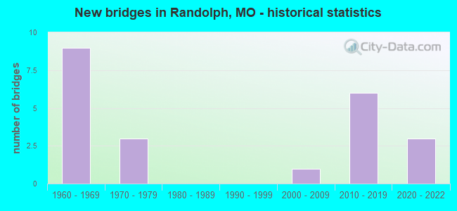
- New bridges - historical statistics
- 91960-1969
- 31970-1979
- 12000-2009
- 62010-2019
- 32020-2022


- Bridge Condition - Deck
- 11.1%Excellent
- 11.1%Very good
- 22.2%Good
- 44.4%Satisfactory
- 11.1%Poor

- Bridge Condition - Superstructure
- 22.2%Excellent
- 11.1%Very good
- 11.1%Good
- 44.4%Satisfactory
- 11.1%Fair

- Bridge Condition - Substructure
- 11.1%Excellent
- 22.2%Very good
- 11.1%Good
- 44.4%Satisfactory
- 11.1%Poor

- Bridge Condition - Channel
- 33.3%Very good
- 33.3%Fair
- 33.3%Poor
Find on map >> Show street view
Structure Number: 1357, Location: S 3 T 50 N R 32 W (Lat: 39.180606, Lng: -94.492769), Route carried "on" structure: Interstate 435, Year Built: 1968, Status: Open, Structure Length: 4.36m (14.30ft), Average Daily Traffic: 35,401 (year 2021), Truck Traffic: 19%, Average Future Daily Traffic: 63,722 (year 2041), Design Load: HS 20, Features Intersected: CST NE 48TH ST
Minimum Vertical Clearance: 30+ m (98+ ft), Kilometerpoint: 34.875, Lanes on structure: 3, Lanes under structure: 4, Base Highway Network: Yes, Owner: State Highway Agency, Approaching Roadway Width: 16.5m (54.1ft), Material/Design: Concrete continuous, Design/Construction: Slab, Number Of Spans In Main Unit: 3, Length of Maximum Span: 20.1m (65.9ft), Curb-To-Curb Width: 15.2m (49.9ft), Out-to-Out Width: 16.1m (52.8ft)
Condition: Deck: Satisfactory, Superstructure: Satisfactory, Substructure: Satisfactory, Operating Rating: 59.4 metric tons, Method Used To Determine Operating Rating: Load Factor (LF), Inventory Rating: 36.0 metric tons, Method Used To Determine Inventory Rating: Load Factor (LF), Structural Evaluation: Equal to present minimum criteria, Deck Geometry: Meets minimum limits, Underclear: Meets minimum limits, Approach Roadway Alignment: Equal to present desirable criteria, Designated Inspection Frequency: Every 24 months, Inspection Date: September 2020, Deck Structure Type: Concrete Cast-file-Place, Wearing Surface/Protective System: Wearing Surface: Low Slump Concrete, Membrane: Built-up
Find on map >> Show street view
Structure Number: 1358, Location: S 3 T 50 N R 32 W (Lat: 39.180603, Lng: -94.493097), Route carried "on" structure: Interstate 435, Year Built: 1968, Status: Open, Structure Length: 4.36m (14.30ft), Average Daily Traffic: 29,501 (year 2021), Truck Traffic: 15%, Average Future Daily Traffic: 53,102 (year 2041), Design Load: HS 20, Features Intersected: CST NE 48TH ST
Minimum Vertical Clearance: 30+ m (98+ ft), Kilometerpoint: 53.953, Lanes on structure: 3, Lanes under structure: 4, Base Highway Network: Yes, Owner: State Highway Agency, Approaching Roadway Width: 16.5m (54.1ft), Material/Design: Concrete continuous, Design/Construction: Slab, Number Of Spans In Main Unit: 3, Length of Maximum Span: 20.1m (65.9ft), Curb-To-Curb Width: 15.2m (49.9ft), Out-to-Out Width: 16.1m (52.8ft)
Condition: Deck: Satisfactory, Superstructure: Satisfactory, Substructure: Satisfactory, Operating Rating: 59.4 metric tons, Method Used To Determine Operating Rating: Load Factor (LF), Inventory Rating: 36.0 metric tons, Method Used To Determine Inventory Rating: Load Factor (LF), Structural Evaluation: Equal to present minimum criteria, Deck Geometry: Meets minimum limits, Underclear: Meets minimum limits, Approach Roadway Alignment: Equal to present desirable criteria, Designated Inspection Frequency: Every 24 months, Inspection Date: September 2020, Deck Structure Type: Concrete Cast-file-Place, Wearing Surface/Protective System: Wearing Surface: Low Slump Concrete, Deck Protection: Cathodic Protection
Find on map >> Show street view
Structure Number: 1365, Location: S 3 T 50 N R 32 W (Lat: 39.168375, Lng: -94.493167), Route carried "on" structure: Interstate 435, Year Built: 1968, Status: Open, Structure Length: 4.66m (15.29ft), Average Daily Traffic: 40,817 (year 2021), Truck Traffic: 19%, Average Future Daily Traffic: 73,471 (year 2041), Design Load: HS 20, Features Intersected: CST NE PARVIN RD
Minimum Vertical Clearance: 30+ m (98+ ft), Kilometerpoint: 33.507, Lanes on structure: 3, Lanes under structure: 5, Base Highway Network: Yes, Owner: State Highway Agency, Approaching Roadway Width: 16.5m (54.1ft), Skew: 1 degrees, Material/Design: Concrete continuous, Design/Construction: Slab, Number Of Spans In Main Unit: 3, Length of Maximum Span: 19.5m (64.0ft), Curb-To-Curb Width: 15.2m (49.9ft), Out-to-Out Width: 16.1m (52.8ft)
Condition: Deck: Satisfactory, Superstructure: Satisfactory, Substructure: Satisfactory, Operating Rating: 61.2 metric tons, Method Used To Determine Operating Rating: Load Factor (LF), Inventory Rating: 36.0 metric tons, Method Used To Determine Inventory Rating: Load Factor (LF), Structural Evaluation: Equal to present minimum criteria, Deck Geometry: Meets minimum limits, Underclear: Meets minimum limits, Approach Roadway Alignment: Equal to present desirable criteria, Designated Inspection Frequency: Every 24 months, Inspection Date: September 2020, Deck Structure Type: Concrete Cast-file-Place, Wearing Surface/Protective System: Wearing Surface: Low Slump Concrete, Membrane: Built-up
Find on map >> Show street view
Structure Number: 1366, Location: S 9 T 50 N R 32 W (Lat: 39.168389, Lng: -94.493458), Route carried "on" structure: Interstate 435, Year Built: 1968, Status: Open, Structure Length: 4.66m (15.29ft), Average Daily Traffic: 34,248 (year 2021), Truck Traffic: 15%, Average Future Daily Traffic: 61,646 (year 2041), Design Load: HS 20, Features Intersected: CST NE PARVIN RD
Minimum Vertical Clearance: 30+ m (98+ ft), Kilometerpoint: 55.316, Lanes on structure: 3, Lanes under structure: 5, Base Highway Network: Yes, Owner: State Highway Agency, Approaching Roadway Width: 16.5m (54.1ft), Skew: 1 degrees, Material/Design: Concrete continuous, Design/Construction: Slab, Number Of Spans In Main Unit: 3, Length of Maximum Span: 19.5m (64.0ft), Curb-To-Curb Width: 15.2m (49.9ft), Out-to-Out Width: 16.1m (52.8ft)
Condition: Deck: Satisfactory, Superstructure: Satisfactory, Substructure: Good, Operating Rating: 61.2 metric tons, Method Used To Determine Operating Rating: Load Factor (LF), Inventory Rating: 36.0 metric tons, Method Used To Determine Inventory Rating: Load Factor (LF), Structural Evaluation: Equal to present minimum criteria, Deck Geometry: Meets minimum limits, Underclear: Meets minimum limits, Approach Roadway Alignment: Equal to present desirable criteria, Designated Inspection Frequency: Every 24 months, Inspection Date: September 2020, Deck Structure Type: Concrete Cast-file-Place, Wearing Surface/Protective System: Wearing Surface: Low Slump Concrete
Find on map >> Show street view
Structure Number: 1656, Location: S 9 T 50 N R 32 W (Lat: 39.155422, Lng: -94.498147), Route carried "on" structure: Interstate 435, Year Built: 1967, Status: Open, Structure Length: 0.70m (2.30ft), Average Daily Traffic: 89,963 (year 2021), Truck Traffic: 15%, Average Future Daily Traffic: 161,933 (year 2041), Design Load: HS 20, Features Intersected: DRAIN DTCH
Minimum Vertical Clearance: 30+ m (98+ ft), Kilometerpoint: 56.839, Lanes on structure: 7, Base Highway Network: Yes, Owner: State Highway Agency, Approaching Roadway Width: 30.5m (100.1ft), Skew: 20 degrees, Material/Design: Concrete continuous, Design/Construction: Culvert, Number Of Spans In Main Unit: 2, Length of Maximum Span: 3.7m (12.1ft)
Condition: Channel: Very good, Culverts: Poor, Structural Evaluation: Meets minimum limits, Waterway Adequacy: Equal to present minimum criteria, Approach Roadway Alignment: Equal to present desirable criteria, Length Of Structure Improvement: 0.13m (0.43ft), Designated Inspection Frequency: Every 12 months, Inspection Date: November 2021, Bridge Improvement Cost: $250,000, Roadway Improvement Cost: $25,000, Total Project Cost: $375,000 ( Estimate for 2022)
Find on map >> Show street view
Structure Number: 32421, Location: S 9 T 50 N R 32 W (Lat: 39.157878, Lng: -94.496439), Route carried "on" structure: City street , Year Built: 2006, Status: Posted for load, Structure Length: 1.52m (4.99ft), Average Daily Traffic: 10 (year 2020), Truck Traffic: 10%, Average Future Daily Traffic: 16 (year 2040), Features Intersected: SMALL CR, Facility Carried by Structure: SIXTH ST
Minimum Vertical Clearance: 30+ m (98+ ft), Kilometerpoint: 0.161, Lanes on structure: 1, Owner: City or Municipal Highway Agency, Approaching Roadway Width: 4.3m (14.1ft), Material/Design: Steel, Design/Construction: Girder and Floorbeam System, Number Of Spans In Main Unit: 1, Length of Maximum Span: 12.5m (41.0ft), Curb-To-Curb Width: 3.5m (11.5ft), Out-to-Out Width: 3.7m (12.1ft)
Condition: Deck: Poor, Superstructure: Fair, Substructure: Satisfactory, Channel: Fair, Operating Rating: 4.5 metric tons, Method Used To Determine Operating Rating: Load Factor (LF), Inventory Rating: 2.7 metric tons, Method Used To Determine Inventory Rating: Load Factor (LF), Structural Evaluation: High priority of replacement, Deck Geometry: High priority of corrective action, Waterway Adequacy: Better than present minimum criteria, Approach Roadway Alignment: High priority of corrective action, Bridge Posting: Required (Relationship of Operating Rating to Maximum Legal Load: > 39.9% below), Length Of Structure Improvement: 0.22m (0.72ft), Designated Inspection Frequency: Every 24 months, Critical Feature Inspection Frequency: Every 24 months, Inspection Date: December 2021, Critical Feature Inspection Date: December 2021, Bridge Improvement Cost: $160,000, Roadway Improvement Cost: $16,000, Total Project Cost: $240,000 ( Estimate for 2022), Deck Structure Type: Other
Find on map >> Show street view
Structure Number: 3533, Location: S 9 T 50 N R 32 W (Lat: 39.159089, Lng: -94.497383), Route carried "on" structure: Interstate 435, Year Built: 2016, Status: Open, Structure Length: 4.51m (14.80ft), Average Daily Traffic: 46,854 (year 2021), Truck Traffic: 19%, Average Future Daily Traffic: 84,337 (year 2041), Features Intersected: MO 210
Minimum Vertical Clearance: 30+ m (98+ ft), Kilometerpoint: 32.409, Lanes on structure: 2, Lanes under structure: 6, Base Highway Network: Yes, Owner: State Highway Agency, Approaching Roadway Width: 15.2m (49.9ft), Skew: 4 degrees, Material/Design: Prestressed concrete, Design/Construction: Box Beam or Girders - Single/Spread, Number Of Spans In Main Unit: 2, Length of Maximum Span: 22.2m (72.8ft), Curb-To-Curb Width: 15.2m (49.9ft), Out-to-Out Width: 16.1m (52.8ft)
Condition: Deck: Good, Superstructure: Excellent, Substructure: Very good, Operating Rating: 69.3 metric tons, Method Used To Determine Operating Rating: Load Factor (LF), Inventory Rating: 41.4 metric tons, Method Used To Determine Inventory Rating: Load Factor (LF), Structural Evaluation: Equal to present desirable criteria, Deck Geometry: Superior to present desirable criteria, Underclear: Superior to present desirable criteria, Approach Roadway Alignment: Equal to present desirable criteria, Designated Inspection Frequency: Every 24 months, Inspection Date: September 2020, Deck Structure Type: Concrete Cast-file-Place, Wearing Surface/Protective System: Wearing Surface: Monolithic Concrete, Deck Protection: Epoxy Coated Reinforcing
Find on map >> Show street view
Structure Number: 35335, Location: S 9 T 50 N R 32 W (Lat: 39.158947, Lng: -94.497717), Route carried "on" structure: Interstate 435, Year Built: 2016, Status: Open, Structure Length: 4.32m (14.17ft), Average Daily Traffic: 36,772 (year 2021), Truck Traffic: 15%, Average Future Daily Traffic: 66,190 (year 2041), Features Intersected: MO 210
Minimum Vertical Clearance: 30+ m (98+ ft), Kilometerpoint: 56.427, Lanes on structure: 3, Lanes under structure: 6, Base Highway Network: Yes, Owner: State Highway Agency, Approaching Roadway Width: 15.2m (49.9ft), Skew: 4 degrees, Material/Design: Prestressed concrete, Design/Construction: Box Beam or Girders - Single/Spread, Number Of Spans In Main Unit: 2, Length of Maximum Span: 21.1m (69.2ft), Curb-To-Curb Width: 15.2m (49.9ft), Out-to-Out Width: 16.1m (52.8ft)
Condition: Deck: Very good, Superstructure: Very good, Substructure: Very good, Operating Rating: 65.7 metric tons, Method Used To Determine Operating Rating: Load Factor (LF), Inventory Rating: 39.6 metric tons, Method Used To Determine Inventory Rating: Load Factor (LF), Structural Evaluation: Equal to present desirable criteria, Deck Geometry: Meets minimum limits, Underclear: Superior to present desirable criteria, Approach Roadway Alignment: Equal to present desirable criteria, Designated Inspection Frequency: Every 24 months, Inspection Date: September 2020, Deck Structure Type: Concrete Cast-file-Place, Wearing Surface/Protective System: Wearing Surface: Monolithic Concrete, Deck Protection: Epoxy Coated Reinforcing
Find on map >> Show street view
Structure Number: 36559, Location: S 34 T 51 N R 32 W (Lat: 39.190569, Lng: -94.492781), Route carried "on" structure: City street , Year Built: 2021, Status: Open, Structure Length: 5.72m (18.77ft), Average Daily Traffic: 7,522 (year 2021), Truck Traffic: 5%, Average Future Daily Traffic: 11,659 (year 2041), Features Intersected: IS 435, Facility Carried by Structure: NE 53RD TER E
Minimum Vertical Clearance: 30+ m (98+ ft), Kilometerpoint: 0.029, Lanes on structure: 2, Lanes under structure: 6, Owner: State Highway Agency, Approaching Roadway Width: 11.6m (38.1ft), Material/Design: Prestressed concrete continuous, Design/Construction: Box Beam or Girders - Single/Spread, Number Of Spans In Main Unit: 2, Length of Maximum Span: 28.0m (91.9ft), Curb or Sidewalk Widths: Left: 1.8m (5.9ft), Right: 0.0m, Curb-To-Curb Width: 9.8m (32.2ft), Out-to-Out Width: 12.5m (41.0ft)
Condition: Deck: Excellent, Superstructure: Excellent, Substructure: Excellent, Inventory Rating: 53.1 metric tons, Method Used To Determine Inventory Rating: Load Factor (LF), Structural Evaluation: Superior to present desirable criteria, Deck Geometry: Meets minimum limits, Underclear: High priority of corrective action, Approach Roadway Alignment: Equal to present desirable criteria, Designated Inspection Frequency: Every 24 months, Inspection Date: January 2022, Deck Structure Type: Concrete Cast-file-Place, Wearing Surface/Protective System: Wearing Surface: Monolithic Concrete, Deck Protection: Epoxy Coated Reinforcing
Find on map >> Show street view
Structure Number: 552, Location: S 9 T 50 N R 32 W (Lat: 39.149986, Lng: -94.498372), Route carried "on" structure: Interstate 435, Year Built: 1972, Year Reconstructed: 2019, Status: Posted for load, Structure Length: 110.31m (361.91ft), Average Daily Traffic: 89,963 (year 2021), Truck Traffic: 15%, Average Future Daily Traffic: 161,933 (year 2041), Design Load: HS 20, Features Intersected: MISSOURI RVR, CST NE BIR
Minimum Vertical Clearance: 9.45m (31.00ft), Kilometerpoint: 56.894, Lanes on structure: 6, Lanes under structure: 4, Base Highway Network: Yes, Owner: State Highway Agency, Approaching Roadway Width: 16.5m (54.1ft), Skew: 20 degrees, Navigation Control: Yes ( Vertical Clearance: 13.7m (44.9ft), Horizontal Clearance: 121.9m (399.9ft)), Material/Design: Steel continuous, Design/Construction: Girder and Floorbeam System, Number Of Spans In Main Unit: 3, Number Of Approach Spans: 17, Length of Maximum Span: 129.5m (424.9ft), Curb-To-Curb Width: 25.5m (83.7ft), Out-to-Out Width: 27.1m (88.9ft)
Condition: Deck: Good, Superstructure: Good, Substructure: Poor, Channel: Poor, Operating Rating: 44.1 metric tons, Method Used To Determine Operating Rating: Load Factor (LF), Inventory Rating: 26.1 metric tons, Method Used To Determine Inventory Rating: Load Factor (LF), Structural Evaluation: Meets minimum limits, Deck Geometry: Meets minimum limits, Underclear: High priority of corrective action, Waterway Adequacy: Equal to present desirable criteria, Approach Roadway Alignment: Equal to present desirable criteria, Designated Inspection Frequency: Every 24 months, Critical Feature Inspection Frequency: Every 24 months, Underwater Inspection Frequency: Every 60 months, Other Special Inspection Frequency: Every 24 months, Inspection Date: September 2021, Critical Feature Inspection Date: September 2021, Underwater Inspection Date: May 2018, Other Special Inspection Date: September 2021, Deck Structure Type: Concrete Cast-file-Place, Wearing Surface/Protective System: Wearing Surface: Monolithic Concrete, Deck Protection: Epoxy Coated Reinforcing
Find on map >> Show street view
Structure Number: 1357, Location: S 3 T 50 N R 32 W (Lat: 39.180606, Lng: -94.492769), Route carried "under" structure: City street , Year Built: 1968, Structure Length: 0. m, Average Daily Traffic: 8,394 (year 2021), Truck Traffic: 3%, Features Intersected: CST NE 48TH ST, Facility Carried by Structure: IS 435 N
Minimum Vertical Clearance: 4.60m (15.09ft), Kilometerpoint: 2.795, Lanes on structure: 3, Lanes under structure: 4, Material/Design: Concrete continuous, Design/Construction: Slab, Length of Maximum Span: 20.1m (65.9ft)
Find on map >> Show street view
Structure Number: 1358, Location: S 3 T 50 N R 32 W (Lat: 39.180603, Lng: -94.493097), Route carried "under" structure: City street , Year Built: 1968, Structure Length: 0. m, Average Daily Traffic: 8,394 (year 2021), Truck Traffic: 3%, Features Intersected: CST NE 48TH ST, Facility Carried by Structure: IS 435 S
Minimum Vertical Clearance: 4.62m (15.16ft), Kilometerpoint: 2.768, Lanes on structure: 3, Lanes under structure: 4, Material/Design: Concrete continuous, Design/Construction: Slab, Length of Maximum Span: 20.1m (65.9ft)
Find on map >> Show street view
Structure Number: 1365, Location: S 3 T 50 N R 32 W (Lat: 39.168375, Lng: -94.493167), Route carried "under" structure: City street , Year Built: 1968, Structure Length: 0. m, Average Daily Traffic: 11,639 (year 2021), Truck Traffic: 5%, Features Intersected: CST NE PARVIN RD, Facility Carried by Structure: IS 435 N
Minimum Vertical Clearance: 4.50m (14.76ft), Kilometerpoint: 7.717, Lanes on structure: 3, Lanes under structure: 5, Material/Design: Concrete continuous, Design/Construction: Slab, Length of Maximum Span: 19.5m (64.0ft)
Find on map >> Show street view
Structure Number: 1366, Location: S 9 T 50 N R 32 W (Lat: 39.168389, Lng: -94.493458), Route carried "under" structure: City street , Year Built: 1968, Structure Length: 0. m, Average Daily Traffic: 11,639 (year 2021), Truck Traffic: 5%, Features Intersected: CST NE PARVIN RD, Facility Carried by Structure: IS 435 S
Minimum Vertical Clearance: 4.50m (14.76ft), Kilometerpoint: 7.691, Lanes on structure: 3, Lanes under structure: 5, Material/Design: Concrete continuous, Design/Construction: Slab, Length of Maximum Span: 19.5m (64.0ft)
Find on map >> Show street view
Structure Number: 3533, Location: S 9 T 50 N R 32 W (Lat: 39.159089, Lng: -94.497383), Route carried "under" structure: State highway 210, Year Built: 2016, Structure Length: 0. m, Average Daily Traffic: 15,612 (year 2021), Truck Traffic: 14%, Features Intersected: MO 210, Facility Carried by Structure: IS 435 N
Minimum Vertical Clearance: 5.21m (17.09ft), Kilometerpoint: 6.159, Lanes on structure: 2, Lanes under structure: 3, Material/Design: Prestressed concrete, Design/Construction: Box Beam or Girders - Single/Spread, Length of Maximum Span: 22.2m (72.8ft)
Find on map >> Show street view
Structure Number: 3533, Location: S 9 T 50 N R 32 W (Lat: 39.159089, Lng: -94.497383), Route carried "under" structure: State highway 210, Year Built: 2016, Structure Length: 0. m, Average Daily Traffic: 16,260 (year 2021), Truck Traffic: 10%, Features Intersected: MO 210, Facility Carried by Structure: IS 435 N
Minimum Vertical Clearance: 5.60m (18.37ft), Kilometerpoint: 47.963, Lanes on structure: 2, Lanes under structure: 3, Material/Design: Prestressed concrete, Design/Construction: Box Beam or Girders - Single/Spread, Length of Maximum Span: 22.2m (72.8ft)
Find on map >> Show street view
Structure Number: 35335, Location: S 9 T 50 N R 32 W (Lat: 39.158947, Lng: -94.497717), Route carried "under" structure: State highway 210, Year Built: 2016, Structure Length: 0. m, Average Daily Traffic: 15,612 (year 2021), Truck Traffic: 14%, Features Intersected: MO 210, Facility Carried by Structure: IS 435 S
Minimum Vertical Clearance: 5.23m (17.16ft), Kilometerpoint: 6.133, Lanes on structure: 3, Lanes under structure: 3, Material/Design: Prestressed concrete, Design/Construction: Box Beam or Girders - Single/Spread, Length of Maximum Span: 21.1m (69.2ft)
Find on map >> Show street view
Structure Number: 35335, Location: S 9 T 50 N R 32 W (Lat: 39.158947, Lng: -94.497717), Route carried "under" structure: State highway 210, Year Built: 2016, Structure Length: 0. m, Average Daily Traffic: 16,260 (year 2021), Truck Traffic: 10%, Features Intersected: MO 210, Facility Carried by Structure: IS 435 S
Minimum Vertical Clearance: 5.57m (18.27ft), Kilometerpoint: 47.989, Lanes on structure: 3, Lanes under structure: 3, Material/Design: Prestressed concrete, Design/Construction: Box Beam or Girders - Single/Spread, Length of Maximum Span: 21.1m (69.2ft)
Find on map >> Show street view
Structure Number: 36559, Location: S 34 T 51 N R 32 W (Lat: 39.190569, Lng: -94.492781), Route carried "under" structure: Interstate 435, Year Built: 2021, Structure Length: 0. m, Average Daily Traffic: 29,501 (year 2021), Truck Traffic: 15%, Features Intersected: IS 435, Facility Carried by Structure: NE 53RD TER E
Minimum Vertical Clearance: 5.06m (16.60ft), Kilometerpoint: 52.870, Lanes on structure: 2, Lanes under structure: 3, Material/Design: Prestressed concrete continuous, Design/Construction: Box Beam or Girders - Single/Spread, Length of Maximum Span: 28.0m (91.9ft)
Find on map >> Show street view
Structure Number: 36559, Location: S 34 T 51 N R 32 W (Lat: 39.190569, Lng: -94.492781), Route carried "under" structure: Interstate 435, Year Built: 2021, Structure Length: 0. m, Average Daily Traffic: 30,465 (year 2021), Truck Traffic: 19%, Features Intersected: IS 435, Facility Carried by Structure: NE 53RD TER E
Minimum Vertical Clearance: 5.06m (16.60ft), Kilometerpoint: 35.999, Lanes on structure: 2, Lanes under structure: 3, Material/Design: Prestressed concrete continuous, Design/Construction: Box Beam or Girders - Single/Spread, Length of Maximum Span: 28.0m (91.9ft)
Find on map >> Show street view
Structure Number: 552, Location: S 9 T 50 N R 32 W (Lat: 39.149986, Lng: -94.498372), Route carried "under" structure: City street , Year Built: 1972, Structure Length: 0. m, Average Daily Traffic: 2 (year 2021), Truck Traffic: 10%, Features Intersected: CST N LEVEE RD, Facility Carried by Structure: IS 435 S
Minimum Vertical Clearance: 3.84m (12.60ft), Kilometerpoint: 5.055, Lanes on structure: 6, Lanes under structure: 2, Material/Design: Steel continuous, Design/Construction: Girder and Floorbeam System, Length of Maximum Span: 129.5m (424.9ft)
Find on map >> Show street view
Structure Number: 552, Location: S 9 T 50 N R 32 W (Lat: 39.149986, Lng: -94.498372), Route carried "under" structure: City street , Year Built: 1972, Structure Length: 0. m, Average Daily Traffic: 2,142 (year 2021), Truck Traffic: 5%, Features Intersected: CST NE BIRMINGHAM RD, Facility Carried by Structure: IS 435 S
Minimum Vertical Clearance: 5.54m (18.18ft), Kilometerpoint: 1.629, Lanes on structure: 6, Lanes under structure: 2, Material/Design: Steel continuous, Design/Construction: Girder and Floorbeam System, Length of Maximum Span: 129.5m (424.9ft)