Bridge Statistics for Rathbone, New York (NY)
Condition, Traffic, Stress, Structural Evaluation, Project Costs
- National Bridge Inventory (NBI) Statistics
- 13Number of bridges
- 125ft / 37.5mTotal length
- $16,046,000Total costs
- 3,230Total average daily traffic
- 246Total average daily truck traffic
- 4,040Total future (year 2037) average daily traffic
- National Bridge Inventory (NBI) Registered Bridges for Rathbone
- No street view available for this location
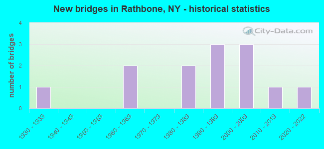
- New bridges - historical statistics
- 11930-1939
- 21960-1969
- 21980-1989
- 31990-1999
- 32000-2009
- 12010-2019
- 12020-2022


- Bridge Condition - Deck
- 33.3%Excellent
- 16.7%Very good
- 25.0%Good
- 16.7%Satisfactory
- 8.3%Fair

- Bridge Condition - Superstructure
- 33.3%Excellent
- 33.3%Good
- 8.3%Satisfactory
- 25.0%Fair

- Bridge Condition - Substructure
- 16.7%Excellent
- 16.7%Very good
- 25.0%Good
- 8.3%Satisfactory
- 16.7%Fair
- 8.3%Poor
- 8.3%Critical

- Bridge Condition - Channel
- 15.4%Excellent
- 15.4%Good
- 30.8%Satisfactory
- 30.8%Fair
- 7.7%Serious
Find on map >> Show street view
Structure Number: 22176, Location: 2.3 MI SW OF RATHBONE (Lat: 42.099078, Lng: -77.335950), Route carried "on" structure: Other road , Year Built: 1994, Status: Posted for load-capacity, Structure Length: 1.95m (6.40ft), Average Daily Traffic: 57 (year 2017), Truck Traffic: 9%, Average Future Daily Traffic: 80 (year 2037), Design Load: HS 20, Features Intersected: N BR TUSCARORA, Facility Carried by Structure: HARDSCRABBLE ROAD
Minimum Vertical Clearance: 30+ m (98+ ft), Kilometerpoint: 0.885, Lanes on structure: 2, Owner: Town or Township Highway Agency, Maintenance Responsibility: County Highway Agency, Approaching Roadway Width: 4.6m (15.1ft), Skew: 1 degrees, Material/Design: Steel, Design/Construction: Stringer/Multi-beam, Number Of Spans In Main Unit: 1, Length of Maximum Span: 18.8m (61.7ft), Curb-To-Curb Width: 7.3m (24.0ft), Out-to-Out Width: 7.7m (25.3ft)
Condition: Deck: Satisfactory, Superstructure: Fair, Substructure: Good, Channel: Good, Operating Rating: 18.8 metric tons, Method Used To Determine Operating Rating: Load and Resistance Factor Rating (LRFR) rating reported by rating factor(RF) method using HL-93 loadings, Inventory Rating: 14.6 metric tons, Method Used To Determine Inventory Rating: Load and Resistance Factor Rating (LRFR) rating reported by rating factor(RF) method using HL-93 loadings, Structural Evaluation: Meets minimum limits, Deck Geometry: Equal to present minimum criteria, Waterway Adequacy: Better than present minimum criteria, Approach Roadway Alignment: Equal to present desirable criteria, Length Of Structure Improvement: 1.95m (6.40ft), Designated Inspection Frequency: Every 24 months, Inspection Date: September 2020, Bridge Improvement Cost: $582,000, Roadway Improvement Cost: $341,000, Total Project Cost: $923,000 ( Estimate for 2021), Deck Structure Type: Wood or Timber, Wearing Surface/Protective System: Wearing Surface: Bituminous, Membrane: Other
Find on map >> Show street view
Structure Number: 221761, Location: 2.9 MI N OF RATHBONE (Lat: 42.173092, Lng: -77.330553), Route carried "on" structure: Other road , Year Built: 2008, Status: Open, Structure Length: 5.55m (18.21ft), Average Daily Traffic: 111 (year 2018), Truck Traffic: 5%, Average Future Daily Traffic: 155 (year 2038), Design Load: HS 25 or greater, Features Intersected: CANISTEO RIVER, Facility Carried by Structure: SAUNDERS ROAD
Minimum Vertical Clearance: 30+ m (98+ ft), Kilometerpoint: 4.199, Lanes on structure: 2, Owner: Town or Township Highway Agency, Maintenance Responsibility: County Highway Agency, Approaching Roadway Width: 8.5m (27.9ft), Skew: 3 degrees, Material/Design: Steel, Design/Construction: Stringer/Multi-beam, Number Of Spans In Main Unit: 1, Length of Maximum Span: 54.9m (180.1ft), Curb-To-Curb Width: 7.9m (25.9ft), Out-to-Out Width: 9.4m (30.8ft)
Condition: Deck: Excellent, Superstructure: Excellent, Substructure: Excellent, Channel: Excellent, Operating Rating: 77.6 metric tons, Method Used To Determine Operating Rating: Load Factor (LF), Inventory Rating: 46.5 metric tons, Method Used To Determine Inventory Rating: Load Factor (LF), Structural Evaluation: Superior to present desirable criteria, Deck Geometry: Somewhat better than minimum adequacy, Waterway Adequacy: Equal to present desirable criteria, Approach Roadway Alignment: Somewhat better than minimum adequacy, Length Of Structure Improvement: 5.54m (18.18ft), Designated Inspection Frequency: Every 24 months, Inspection Date: August 2020, Bridge Improvement Cost: $1,915,000, Roadway Improvement Cost: $1,121,000, Total Project Cost: $3,036,000 ( Estimate for 2021), Deck Structure Type: Concrete Cast-file-Place, Wearing Surface/Protective System: Wearing Surface: Monolithic Concrete, Deck Protection: Epoxy Coated Reinforcing
Find on map >> Show street view
Structure Number: 221762, Location: 1.4 MI NW OF RATHBONE (Lat: 42.147239, Lng: -77.341403), Route carried "on" structure: Other road , Year Built: 1963, Year Reconstructed: 1994, Status: Open, Structure Length: 0.88m (2.89ft), Average Daily Traffic: 64 (year 2017), Truck Traffic: 5%, Average Future Daily Traffic: 90 (year 2037), Design Load: HS 20, Features Intersected: TRACY CREEK, Facility Carried by Structure: LEARN RD
Minimum Vertical Clearance: 30+ m (98+ ft), Kilometerpoint: 4.489, Lanes on structure: 2, Owner: Town or Township Highway Agency, Maintenance Responsibility: County Highway Agency, Approaching Roadway Width: 7.3m (24.0ft), Skew: 3 degrees, Material/Design: Steel, Design/Construction: Stringer/Multi-beam, Number Of Spans In Main Unit: 1, Length of Maximum Span: 8.5m (27.9ft), Curb-To-Curb Width: 8.3m (27.2ft), Out-to-Out Width: 8.5m (27.9ft)
Condition: Deck: Satisfactory, Superstructure: Fair, Substructure: Poor, Channel: Serious, Operating Rating: 62.6 metric tons, Method Used To Determine Operating Rating: Load Factor (LF), Inventory Rating: 44.5 metric tons, Method Used To Determine Inventory Rating: Load Factor (LF), Structural Evaluation: Meets minimum limits, Deck Geometry: Equal to present minimum criteria, Waterway Adequacy: Better than present minimum criteria, Approach Roadway Alignment: Somewhat better than minimum adequacy, Length Of Structure Improvement: 0.88m (2.89ft), Designated Inspection Frequency: Every 24 months, Inspection Date: November 2021, Bridge Improvement Cost: $483,000, Roadway Improvement Cost: $283,000, Total Project Cost: $766,000 ( Estimate for 2021), Deck Structure Type: Wood or Timber, Wearing Surface/Protective System: Wearing Surface: Bituminous, Membrane: Other
Find on map >> Show street view
Structure Number: 221763, Location: 2.4 MI SW OF RATHBONE (Lat: 42.116331, Lng: -77.357411), Route carried "on" structure: Other road , Year Built: 2020, Status: Open, Structure Length: 1.83m (6.00ft), Average Daily Traffic: 72 (year 2017), Truck Traffic: 5%, Average Future Daily Traffic: 101 (year 2037), Design Load: HS 25 or greater, Features Intersected: N BR TUSCARORA CK, Facility Carried by Structure: MERRING ROAD
Minimum Vertical Clearance: 30+ m (98+ ft), Kilometerpoint: 3.138, Lanes on structure: 2, Owner: Town or Township Highway Agency, Maintenance Responsibility: County Highway Agency, Approaching Roadway Width: 8.2m (26.9ft), Material/Design: Prestressed concrete, Design/Construction: Box Beam or Girders - Multiple, Number Of Spans In Main Unit: 1, Length of Maximum Span: 17.7m (58.1ft), Curb-To-Curb Width: 8.2m (26.9ft), Out-to-Out Width: 8.7m (28.5ft)
Condition: Deck: Excellent, Superstructure: Excellent, Substructure: Excellent, Channel: Excellent, Operating Rating: 88.0 metric tons, Method Used To Determine Operating Rating: Load Factor (LF), Inventory Rating: 52.6 metric tons, Method Used To Determine Inventory Rating: Load Factor (LF), Structural Evaluation: Superior to present desirable criteria, Deck Geometry: Equal to present minimum criteria, Waterway Adequacy: Better than present minimum criteria, Approach Roadway Alignment: Equal to present desirable criteria, Length Of Structure Improvement: 1.82m (5.97ft), Designated Inspection Frequency: Every 24 months, Inspection Date: September 2020, Bridge Improvement Cost: $410,000, Roadway Improvement Cost: $240,000, Total Project Cost: $651,000 ( Estimate for 2021), Wearing Surface/Protective System: Wearing Surface: Bituminous, Membrane: Other
Find on map >> Show street view
Structure Number: 221764, Location: 2 MILES SOUTH OF RATHBONE (Lat: 42.106439, Lng: -77.339625), Route carried "on" structure: Other road , Year Built: 2011, Status: Open, Structure Length: 1.83m (6.00ft), Average Daily Traffic: 126 (year 2017), Truck Traffic: 11%, Average Future Daily Traffic: 176 (year 2037), Design Load: HS 25 or greater, Features Intersected: N B TUSCARORA CRK, Facility Carried by Structure: DERBY HILL ROAD
Minimum Vertical Clearance: 30+ m (98+ ft), Kilometerpoint: 0.000, Lanes on structure: 2, Owner: Town or Township Highway Agency, Maintenance Responsibility: County Highway Agency, Approaching Roadway Width: 6.4m (21.0ft), Material/Design: Prestressed concrete, Design/Construction: Box Beam or Girders - Multiple, Number Of Spans In Main Unit: 1, Length of Maximum Span: 17.7m (58.1ft), Curb-To-Curb Width: 8.2m (26.9ft), Out-to-Out Width: 8.7m (28.5ft)
Condition: Deck: Excellent, Superstructure: Excellent, Substructure: Good, Channel: Fair, Operating Rating: 66.2 metric tons, Method Used To Determine Operating Rating: Load Factor (LF), Inventory Rating: 39.9 metric tons, Method Used To Determine Inventory Rating: Load Factor (LF), Structural Evaluation: Better than present minimum criteria, Deck Geometry: Somewhat better than minimum adequacy, Waterway Adequacy: Somewhat better than minimum adequacy, Approach Roadway Alignment: Equal to present desirable criteria, Length Of Structure Improvement: 1.82m (5.97ft), Designated Inspection Frequency: Every 24 months, Inspection Date: November 2021, Bridge Improvement Cost: $359,000, Roadway Improvement Cost: $210,000, Total Project Cost: $569,000 ( Estimate for 2021), Wearing Surface/Protective System: Wearing Surface: Bituminous, Membrane: Other
Find on map >> Show street view
Structure Number: 221765, Location: 1.5 MI SE OF RATHBONE (Lat: 42.116219, Lng: -77.299631), Route carried "on" structure: Other road , Year Built: 1987, Status: Posted for load-capacity, Structure Length: 6.68m (21.92ft), Average Daily Traffic: 82 (year 2017), Truck Traffic: 6%, Average Future Daily Traffic: 115 (year 2037), Design Load: HS 15, Features Intersected: CANISTEO RIVER, Facility Carried by Structure: NEWCOMB ROAD
Minimum Vertical Clearance: 30+ m (98+ ft), Kilometerpoint: 2.043, Lanes on structure: 1, Owner: Town or Township Highway Agency, Maintenance Responsibility: County Highway Agency, Approaching Roadway Width: 4.3m (14.1ft), Material/Design: Steel, Design/Construction: Stringer/Multi-beam, Number Of Spans In Main Unit: 3, Length of Maximum Span: 22.5m (73.8ft), Curb-To-Curb Width: 4.4m (14.4ft), Out-to-Out Width: 5.2m (17.1ft)
Condition: Deck: Fair, Superstructure: Fair, Substructure: Critical, Channel: Fair, Operating Rating: 34.5 metric tons, Method Used To Determine Operating Rating: Load Factor (LF), Inventory Rating: 25.4 metric tons, Method Used To Determine Inventory Rating: Load Factor (LF), Structural Evaluation: High priority of replacement, Deck Geometry: Equal to present minimum criteria, Waterway Adequacy: Meets minimum limits, Approach Roadway Alignment: Meets minimum limits, Length Of Structure Improvement: 6.67m (21.88ft), Designated Inspection Frequency: Every 24 months, Critical Feature Inspection Frequency: Every 24 months, Underwater Inspection Frequency: Every 60 months, Inspection Date: August 2020, Critical Feature Inspection Date: August 2020, Underwater Inspection Date: June 2019, Bridge Improvement Cost: $905,000, Roadway Improvement Cost: $530,000, Total Project Cost: $1,436,000 ( Estimate for 2021), Deck Structure Type: Wood or Timber, Wearing Surface/Protective System: Wearing Surface: Bituminous
Find on map >> Show street view
Structure Number: 333328, Location: IN RATHBONE (Lat: 42.136006, Lng: -77.320672), Route carried "on" structure: County highway , Year Built: 1990, Status: Open, Structure Length: 7.25m (23.79ft), Average Daily Traffic: 601 (year 2018), Truck Traffic: 6%, Average Future Daily Traffic: 841 (year 2038), Design Load: HS 20, Features Intersected: CANISTEO RIVER, Facility Carried by Structure: COUNTY ROAD 21
Minimum Vertical Clearance: 30+ m (98+ ft), Kilometerpoint: 25.985, Lanes on structure: 2, Owner: County Highway Agency, Approaching Roadway Width: 8.5m (27.9ft), Material/Design: Steel continuous, Design/Construction: Stringer/Multi-beam, Number Of Spans In Main Unit: 2, Length of Maximum Span: 35.3m (115.8ft), Curb-To-Curb Width: 8.5m (27.9ft), Out-to-Out Width: 9.1m (29.9ft)
Condition: Deck: Good, Superstructure: Good, Substructure: Satisfactory, Channel: Satisfactory, Operating Rating: 73.5 metric tons, Method Used To Determine Operating Rating: Allowable Stress (AS), Inventory Rating: 32.7 metric tons, Method Used To Determine Inventory Rating: Allowable Stress (AS), Structural Evaluation: Equal to present minimum criteria, Deck Geometry: Somewhat better than minimum adequacy, Waterway Adequacy: Superior to present desirable criteria, Approach Roadway Alignment: Equal to present minimum criteria, Length Of Structure Improvement: 7.25m (23.79ft), Designated Inspection Frequency: Every 24 months, Inspection Date: July 2021, Bridge Improvement Cost: $1,810,000, Roadway Improvement Cost: $1,060,000, Total Project Cost: $2,870,000 ( Estimate for 2021), Deck Structure Type: Concrete Cast-file-Place, Wearing Surface/Protective System: Wearing Surface: Integral Concrete, Deck Protection: Epoxy Coated Reinforcing
Find on map >> Show street view
Structure Number: 33333, Location: 1.1 MI E OF CAMERON MILLS (Lat: 42.182394, Lng: -77.347842), Route carried "on" structure: County highway , Year Built: 1937, Year Reconstructed: 1991, Status: Open, Structure Length: 1.07m (3.51ft), Average Daily Traffic: 417 (year 2018), Truck Traffic: 8%, Average Future Daily Traffic: 435 (year 2040), Design Load: HS 20, Features Intersected: TRIB HELMER CREEK, Facility Carried by Structure: COUNTY ROAD 24
Minimum Vertical Clearance: 30+ m (98+ ft), Kilometerpoint: 0.788, Lanes on structure: 2, Owner: County Highway Agency, Approaching Roadway Width: 6.4m (21.0ft), Material/Design: Steel, Design/Construction: Stringer/Multi-beam, Number Of Spans In Main Unit: 1, Length of Maximum Span: 10.0m (32.8ft), Curb-To-Curb Width: 8.7m (28.5ft), Out-to-Out Width: 9.0m (29.5ft)
Condition: Deck: Very good, Superstructure: Good, Substructure: Fair, Channel: Fair, Operating Rating: 89.8 metric tons, Method Used To Determine Operating Rating: Load Factor (LF), Inventory Rating: 89.8 metric tons, Method Used To Determine Inventory Rating: Load Factor (LF), Structural Evaluation: Somewhat better than minimum adequacy, Deck Geometry: Somewhat better than minimum adequacy, Waterway Adequacy: Meets minimum limits, Approach Roadway Alignment: Equal to present desirable criteria, Length Of Structure Improvement: 1.06m (3.48ft), Designated Inspection Frequency: Every 24 months, Inspection Date: May 2021, Bridge Improvement Cost: $621,000, Roadway Improvement Cost: $364,000, Total Project Cost: $985,000 ( Estimate for 2021), Deck Structure Type: Wood or Timber, Wearing Surface/Protective System: Wearing Surface: Bituminous, Membrane: Other
Find on map >> Show street view
Structure Number: 333404, Location: 0.5 MI NW OF RATHBONE (Lat: 42.137947, Lng: -77.324128), Route carried "on" structure: County highway , Year Built: 1990, Status: Open, Structure Length: 1.10m (3.61ft), Average Daily Traffic: 295 (year 2017), Truck Traffic: 21%, Average Future Daily Traffic: 413 (year 2037), Design Load: HS 25 or greater, Features Intersected: TRACY CREEK, Facility Carried by Structure: COUNTY ROAD 80
Minimum Vertical Clearance: 30+ m (98+ ft), Kilometerpoint: 7.417, Lanes on structure: 2, Owner: County Highway Agency, Approaching Roadway Width: 6.1m (20.0ft), Material/Design: Prestressed concrete, Design/Construction: Box Beam or Girders - Multiple, Number Of Spans In Main Unit: 1, Length of Maximum Span: 10.6m (34.8ft), Curb-To-Curb Width: 8.1m (26.6ft), Out-to-Out Width: 8.6m (28.2ft)
Condition: Deck: Good, Superstructure: Good, Substructure: Good, Channel: Satisfactory, Operating Rating: 58.1 metric tons, Method Used To Determine Operating Rating: Load Factor (LF), Inventory Rating: 49.9 metric tons, Method Used To Determine Inventory Rating: Load Factor (LF), Structural Evaluation: Better than present minimum criteria, Deck Geometry: Somewhat better than minimum adequacy, Waterway Adequacy: Better than present minimum criteria, Approach Roadway Alignment: Better than present minimum criteria, Length Of Structure Improvement: 1.09m (3.58ft), Designated Inspection Frequency: Every 24 months, Inspection Date: October 2021, Bridge Improvement Cost: $355,000, Roadway Improvement Cost: $208,000, Total Project Cost: $563,000 ( Estimate for 2021), Wearing Surface/Protective System: Wearing Surface: Bituminous
Find on map >> Show street view
Structure Number: 333405, Location: 2.8 MI SE OF CAMERON (Lat: 42.162175, Lng: -77.384608), Route carried "on" structure: County highway , Year Built: 2001, Status: Open, Structure Length: 0.82m (2.69ft), Average Daily Traffic: 159 (year 2017), Truck Traffic: 9%, Average Future Daily Traffic: 223 (year 2037), Design Load: HS 25 or greater, Features Intersected: TRACY CREEK, Facility Carried by Structure: COUNTY ROAD 80
Minimum Vertical Clearance: 30+ m (98+ ft), Kilometerpoint: 1.110, Lanes on structure: 2, Owner: County Highway Agency, Approaching Roadway Width: 6.7m (22.0ft), Skew: 2 degrees, Material/Design: Prestressed concrete, Design/Construction: Slab, Number Of Spans In Main Unit: 1, Length of Maximum Span: 7.6m (24.9ft), Curb-To-Curb Width: 8.2m (26.9ft), Out-to-Out Width: 8.7m (28.5ft)
Condition: Deck: Very good, Superstructure: Satisfactory, Substructure: Very good, Channel: Satisfactory, Operating Rating: 87.1 metric tons, Method Used To Determine Operating Rating: Load Factor (LF), Inventory Rating: 50.8 metric tons, Method Used To Determine Inventory Rating: Load Factor (LF), Structural Evaluation: Equal to present minimum criteria, Deck Geometry: Somewhat better than minimum adequacy, Waterway Adequacy: Somewhat better than minimum adequacy, Approach Roadway Alignment: Equal to present desirable criteria, Length Of Structure Improvement: 0.82m (2.69ft), Designated Inspection Frequency: Every 24 months, Inspection Date: November 2021, Bridge Improvement Cost: $307,000, Roadway Improvement Cost: $180,000, Total Project Cost: $487,000 ( Estimate for 2021), Wearing Surface/Protective System: Wearing Surface: Bituminous, Membrane: Other
Find on map >> Show street view
Structure Number: 333406, Location: 2.1 MI SW OF RATHBONE (Lat: 42.110697, Lng: -77.348925), Route carried "on" structure: County highway , Year Built: 1967, Status: Open, Structure Length: 1.98m (6.50ft), Average Daily Traffic: 196 (year 2017), Truck Traffic: 5%, Average Future Daily Traffic: 274 (year 2037), Design Load: H 20, Features Intersected: N BR TUSCARORA CK, Facility Carried by Structure: COUNTY ROAD 81
Minimum Vertical Clearance: 30+ m (98+ ft), Kilometerpoint: 3.572, Lanes on structure: 2, Owner: County Highway Agency, Approaching Roadway Width: 7.0m (23.0ft), Material/Design: Concrete continuous, Design/Construction: Culvert, Number Of Spans In Main Unit: 3, Length of Maximum Span: 6.4m (21.0ft)
Condition: Channel: Satisfactory, Culverts: Good, Operating Rating: 89.8 metric tons, Method Used To Determine Operating Rating: Load Factor (LF), Inventory Rating: 13.6 metric tons, Method Used To Determine Inventory Rating: Load Factor (LF), Structural Evaluation: Meets minimum limits, Waterway Adequacy: Better than present minimum criteria, Approach Roadway Alignment: Equal to present desirable criteria, Length Of Structure Improvement: 1.98m (6.50ft), Designated Inspection Frequency: Every 24 months, Inspection Date: October 2021, Bridge Improvement Cost: $509,000, Roadway Improvement Cost: $298,000, Total Project Cost: $808,000 ( Estimate for 2021)
Find on map >> Show street view
Structure Number: 333432, Location: 8.5 MILES NE OF ADDISON (Lat: 42.178411, Lng: -77.363456), Route carried "on" structure: County highway , Year Built: 2005, Status: Open, Structure Length: 5.46m (17.91ft), Average Daily Traffic: 117 (year 2020), Truck Traffic: 5%, Average Future Daily Traffic: 164 (year 2040), Design Load: HS 25 or greater, Features Intersected: CANISTEO RIVER, Facility Carried by Structure: COUNTY ROAD 110
Minimum Vertical Clearance: 30+ m (98+ ft), Kilometerpoint: 2.751, Lanes on structure: 2, Owner: County Highway Agency, Approaching Roadway Width: 8.5m (27.9ft), Skew: 1 degrees, Material/Design: Steel continuous, Design/Construction: Stringer/Multi-beam, Number Of Spans In Main Unit: 3, Length of Maximum Span: 21.0m (68.9ft), Curb-To-Curb Width: 8.4m (27.6ft), Out-to-Out Width: 9.4m (30.8ft)
Condition: Deck: Excellent, Superstructure: Excellent, Substructure: Very good, Channel: Good, Operating Rating: 82.6 metric tons, Method Used To Determine Operating Rating: Load Factor (LF), Inventory Rating: 49.9 metric tons, Method Used To Determine Inventory Rating: Load Factor (LF), Structural Evaluation: Equal to present desirable criteria, Deck Geometry: Somewhat better than minimum adequacy, Waterway Adequacy: Somewhat better than minimum adequacy, Approach Roadway Alignment: Equal to present minimum criteria, Length Of Structure Improvement: 5.45m (17.88ft), Designated Inspection Frequency: Every 24 months, Inspection Date: July 2021, Bridge Improvement Cost: $1,511,000, Roadway Improvement Cost: $885,000, Total Project Cost: $2,396,000 ( Estimate for 2021), Deck Structure Type: Concrete Cast-file-Place, Wearing Surface/Protective System: Wearing Surface: Integral Concrete, Deck Protection: Epoxy Coated Reinforcing
Find on map >> Show street view
Structure Number: 333445, Location: 1.4 MI E OF CAMERON MILLS (Lat: 42.175875, Lng: -77.340742), Route carried "on" structure: County highway , Year Built: 1989, Status: Open, Structure Length: 1.10m (3.61ft), Average Daily Traffic: 933 (year 2018), Truck Traffic: 6%, Average Future Daily Traffic: 973 (year 2040), Features Intersected: HELMER CREEK, Facility Carried by Structure: COUNTY ROAD 119
Minimum Vertical Clearance: 30+ m (98+ ft), Kilometerpoint: 14.304, Lanes on structure: 2, Owner: County Highway Agency, Approaching Roadway Width: 7.3m (24.0ft), Skew: 1 degrees, Material/Design: Wood or Timber, Design/Construction: Slab, Number Of Spans In Main Unit: 1, Length of Maximum Span: 10.3m (33.8ft), Curb-To-Curb Width: 9.2m (30.2ft), Out-to-Out Width: 9.8m (32.2ft)
Condition: Deck: Good, Superstructure: Good, Substructure: Fair, Channel: Fair, Operating Rating: 49.9 metric tons, Method Used To Determine Operating Rating: Allowable Stress (AS), Inventory Rating: 32.7 metric tons, Method Used To Determine Inventory Rating: Allowable Stress (AS), Structural Evaluation: Somewhat better than minimum adequacy, Deck Geometry: Equal to present minimum criteria, Waterway Adequacy: Meets minimum limits, Approach Roadway Alignment: Equal to present desirable criteria, Length Of Structure Improvement: 1.09m (3.58ft), Designated Inspection Frequency: Every 24 months, Inspection Date: May 2021, Bridge Improvement Cost: $350,000, Roadway Improvement Cost: $205,000, Total Project Cost: $556,000 ( Estimate for 2021), Wearing Surface/Protective System: Wearing Surface: Bituminous