Bridge Statistics for Raymond, Nebraska (NE)
Condition, Traffic, Stress, Structural Evaluation, Project Costs
- National Bridge Inventory (NBI) Statistics
- 22Number of bridges
- 138ft / 42.4mTotal length
- 25,628Total average daily traffic
- 2,092Total average daily truck traffic
- 39,543Total future (year 2033) average daily traffic
- National Bridge Inventory (NBI) Registered Bridges for Raymond
- No street view available for this location
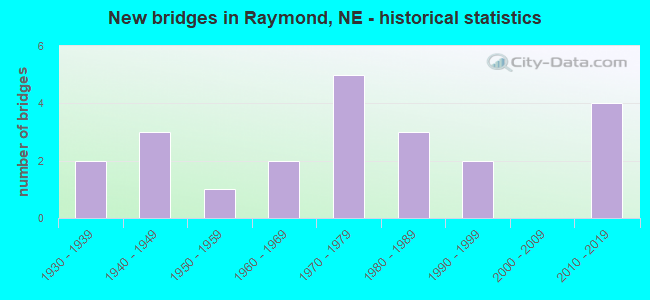
- New bridges - historical statistics
- 21930-1939
- 31940-1949
- 11950-1959
- 21960-1969
- 51970-1979
- 31980-1989
- 21990-1999
- 42010-2019

- Reconstructed bridges - Historical Statistics
- 21970-1979
- 01980-1989
- 01990-1999
- 22000-2009


- Bridge Condition - Deck
- 45.5%Good
- 18.2%Satisfactory
- 18.2%Fair
- 9.1%Poor
- 9.1%Serious

- Bridge Condition - Superstructure
- 36.4%Good
- 18.2%Satisfactory
- 27.3%Fair
- 18.2%Poor

- Bridge Condition - Substructure
- 18.2%Good
- 45.5%Satisfactory
- 36.4%Fair

- Bridge Condition - Channel
- 9.1%Excellent
- 18.2%Good
- 22.7%Satisfactory
- 45.5%Fair
- 4.5%Poor

- Bridge Condition - Culverts
- 9.1%Excellent
- 27.3%Very good
- 27.3%Good
- 9.1%Satisfactory
- 27.3%Fair
Find on map >> Show street view
Structure Number: C00550062, Location: JCT US77/S-55J 4N 1.2E (Lat: 41.016800, Lng: -96.772900), Route carried "on" structure: County highway 3380, Year Built: 1962, Status: Open, Structure Length: 2.26m (7.41ft), Average Daily Traffic: 486 (year 2016), Average Future Daily Traffic: 826 (year 2042), Design Load: H 20, Features Intersected: LITTLE SALT CR (C 125)
Minimum Vertical Clearance: 30+ m (98+ ft), Kilometerpoint: 1.160, Lanes on structure: 2, Owner: County Highway Agency, Approaching Roadway Width: 6.7m (22.0ft), Material/Design: Concrete continuous, Design/Construction: Slab, Number Of Spans In Main Unit: 3, Length of Maximum Span: 9.1m (29.9ft), Curb or Sidewalk Widths: Left: 0.7m (2.3ft), Right: 0.7m (2.3ft), Curb-To-Curb Width: 7.9m (25.9ft), Out-to-Out Width: 9.4m (30.8ft)
Condition: Deck: Good, Superstructure: Good, Substructure: Satisfactory, Channel: Fair, Operating Rating: 44.0 metric tons, Method Used To Determine Operating Rating: Load Factor (LF), Inventory Rating: 25.0 metric tons, Method Used To Determine Inventory Rating: Load Factor (LF), Structural Evaluation: Equal to present minimum criteria, Deck Geometry: Somewhat better than minimum adequacy, Waterway Adequacy: Equal to present minimum criteria, Approach Roadway Alignment: Equal to present desirable criteria, Designated Inspection Frequency: Every 24 months, Inspection Date: March 2022, Deck Structure Type: Concrete Cast-file-Place, Wearing Surface/Protective System: Wearing Surface: Monolithic Concrete
Find on map >> Show street view
Structure Number: C005501210P, Location: 1.75W .5N OF RAYMOND (Lat: 40.966200, Lng: -96.831800), Route carried "on" structure: County highway P12, Year Built: 1972, Status: Open, Structure Length: 0.79m (2.59ft), Average Daily Traffic: 31 (year 2018), Average Future Daily Traffic: 52 (year 2039), Features Intersected: STREAM (D 123), Facility Carried by Structure: COUNTY HIGHWAY
Minimum Vertical Clearance: 30+ m (98+ ft), Kilometerpoint: 0.000, Lanes on structure: 2, Owner: County Highway Agency, Approaching Roadway Width: 8.5m (27.9ft), Material/Design: Concrete, Design/Construction: Culvert, Number Of Spans In Main Unit: 2, Length of Maximum Span: 3.7m (12.1ft)
Condition: Channel: Fair, Culverts: Fair, Operating Rating: 33.0 metric tons, Method Used To Determine Operating Rating: Field evaluation and documented engineering judgment, Inventory Rating: 22.0 metric tons, Method Used To Determine Inventory Rating: Field evaluation and documented engineering judgment, Structural Evaluation: Somewhat better than minimum adequacy, Waterway Adequacy: Equal to present minimum criteria, Approach Roadway Alignment: Better than present minimum criteria, Designated Inspection Frequency: Every 24 months, Inspection Date: Febuary 2021
Find on map >> Show street view
Structure Number: C005501405, Location: JCT N79/S-55J 1.9W (Lat: 40.958900, Lng: -96.833100), Route carried "on" structure: County highway 3370, Year Built: 1968, Status: Open, Structure Length: 0.67m (2.20ft), Average Daily Traffic: 1,115 (year 2011), Average Future Daily Traffic: 1,110 (year 2033), Features Intersected: OAK CREEK (D 5)
Minimum Vertical Clearance: 30+ m (98+ ft), Kilometerpoint: 1.267, Lanes on structure: 2, Owner: County Highway Agency, Approaching Roadway Width: 6.7m (22.0ft), Material/Design: Concrete, Design/Construction: Culvert, Number Of Spans In Main Unit: 2, Length of Maximum Span: 3.0m (9.8ft)
Condition: Channel: Poor, Culverts: Fair, Operating Rating: 33.0 metric tons, Method Used To Determine Operating Rating: Load Factor (LF), Inventory Rating: 22.0 metric tons, Method Used To Determine Inventory Rating: Load Factor (LF), Structural Evaluation: Somewhat better than minimum adequacy, Waterway Adequacy: Meets minimum limits, Approach Roadway Alignment: Equal to present desirable criteria, Designated Inspection Frequency: Every 24 months, Inspection Date: July 2020
Find on map >> Show street view
Structure Number: C005501807, Location: 1.5N 2.5E OF MALCOLM (Lat: 40.930100, Lng: -96.815800), Route carried "on" structure: County highway 7826, Year Built: 1974, Status: Open, Structure Length: 0.67m (2.20ft), Average Daily Traffic: 187 (year 2014), Average Future Daily Traffic: 318 (year 2035), Features Intersected: STREAM (E 163)
Minimum Vertical Clearance: 30+ m (98+ ft), Kilometerpoint: 0.480, Lanes on structure: 2, Owner: County Highway Agency, Approaching Roadway Width: 8.5m (27.9ft), Material/Design: Concrete, Design/Construction: Culvert, Number Of Spans In Main Unit: 2, Length of Maximum Span: 3.0m (9.8ft)
Condition: Channel: Satisfactory, Culverts: Satisfactory, Operating Rating: 33.0 metric tons, Method Used To Determine Operating Rating: Field evaluation and documented engineering judgment, Inventory Rating: 22.0 metric tons, Method Used To Determine Inventory Rating: Field evaluation and documented engineering judgment, Structural Evaluation: Equal to present minimum criteria, Waterway Adequacy: Equal to present desirable criteria, Approach Roadway Alignment: Equal to present desirable criteria, Designated Inspection Frequency: Every 24 months, Inspection Date: March 2021
Find on map >> Show street view
Structure Number: C00550181, Location: 2S OF RAYMOND (Lat: 40.930200, Lng: -96.774300), Route carried "on" structure: County highway 18, Year Built: 1972, Status: Posted for load, Structure Length: 4.11m (13.48ft), Average Daily Traffic: 169 (year 2017), Truck Traffic: 10%, Average Future Daily Traffic: 287 (year 2036), Features Intersected: OAK CREEK (F 181), Facility Carried by Structure: W WAVERLY RD
Minimum Vertical Clearance: 30+ m (98+ ft), Kilometerpoint: 0.000, Lanes on structure: 2, Owner: County Highway Agency, Approaching Roadway Width: 8.5m (27.9ft), Material/Design: Prestressed concrete, Design/Construction: Tee Beam, Number Of Spans In Main Unit: 3, Length of Maximum Span: 13.7m (44.9ft), Curb or Sidewalk Widths: Left: 0.3m (1.0ft), Right: 0.3m (1.0ft), Curb-To-Curb Width: 8.5m (27.9ft), Out-to-Out Width: 9.1m (29.9ft)
Condition: Deck: Poor, Superstructure: Poor, Substructure: Satisfactory, Channel: Fair, Operating Rating: 36.0 metric tons, Method Used To Determine Operating Rating: Load Factor (LF), Inventory Rating: 18.0 metric tons, Method Used To Determine Inventory Rating: Load Factor (LF), Structural Evaluation: Meets minimum limits, Deck Geometry: Equal to present minimum criteria, Waterway Adequacy: Equal to present minimum criteria, Approach Roadway Alignment: Equal to present desirable criteria, Bridge Posting: Required (Relationship of Operating Rating to Maximum Legal Load: 0.1 - 9.9% below), Length Of Structure Improvement: 4.11m (13.48ft), Designated Inspection Frequency: Every 24 months, Inspection Date: November 2021, Deck Structure Type: Concrete Cast-file-Place, Wearing Surface/Protective System: Wearing Surface: Bituminous
Find on map >> Show street view
Structure Number: C00551081, Location: 3N OF RAYMOND (Lat: 41.002300, Lng: -96.800300), Route carried "on" structure: County highway 108, Year Built: 1985, Status: Open, Structure Length: 3.96m (12.99ft), Average Daily Traffic: 55 (year 2017), Average Future Daily Traffic: 93 (year 2038), Design Load: H 20, Features Intersected: NORTH OAK CREEK (D 203), Facility Carried by Structure: W ROCK CREEK RD
Minimum Vertical Clearance: 30+ m (98+ ft), Kilometerpoint: 0.000, Lanes on structure: 2, Owner: County Highway Agency, Approaching Roadway Width: 9.1m (29.9ft), Material/Design: Concrete continuous, Design/Construction: Slab, Number Of Spans In Main Unit: 3, Length of Maximum Span: 15.8m (51.8ft), Curb-To-Curb Width: 8.5m (27.9ft), Out-to-Out Width: 9.2m (30.2ft)
Condition: Deck: Good, Superstructure: Good, Substructure: Fair, Channel: Fair, Operating Rating: 50.0 metric tons, Method Used To Determine Operating Rating: Load Factor (LF), Inventory Rating: 30.0 metric tons, Method Used To Determine Inventory Rating: Load Factor (LF), Structural Evaluation: Somewhat better than minimum adequacy, Deck Geometry: Better than present minimum criteria, Waterway Adequacy: Equal to present minimum criteria, Approach Roadway Alignment: Equal to present desirable criteria, Length Of Structure Improvement: 3.96m (12.99ft), Designated Inspection Frequency: Every 24 months, Inspection Date: July 2020, Deck Structure Type: Concrete Cast-file-Place, Wearing Surface/Protective System: Wearing Surface: Monolithic Concrete
Find on map >> Show street view
Structure Number: C005510815, Location: 3N .5E OF RAYMOND (Lat: 41.002300, Lng: -96.767600), Route carried "on" structure: County highway 108, Year Built: 1935, Year Reconstructed: 1978, Status: Posted for load, Structure Length: 2.32m (7.61ft), Average Daily Traffic: 50 (year 2003), Average Future Daily Traffic: 85 (year 2033), Design Load: H 15, Features Intersected: LITTLE SALT CR (C 220), Facility Carried by Structure: W ROCK CREEK RD
Minimum Vertical Clearance: 30+ m (98+ ft), Kilometerpoint: 0.000, Lanes on structure: 2, Owner: County Highway Agency, Approaching Roadway Width: 8.2m (26.9ft), Material/Design: Steel, Design/Construction: Truss - Thru, Number Of Spans In Main Unit: 1, Length of Maximum Span: 22.9m (75.1ft), Curb-To-Curb Width: 7.3m (24.0ft), Out-to-Out Width: 7.5m (24.6ft)
Condition: Deck: Good, Superstructure: Fair, Substructure: Good, Channel: Good, Operating Rating: 10.0 metric tons, Method Used To Determine Operating Rating: Load Factor (LF), Inventory Rating: 6.0 metric tons, Method Used To Determine Inventory Rating: Load Factor (LF), Structural Evaluation: High priority of replacement, Deck Geometry: Equal to present minimum criteria, Waterway Adequacy: Equal to present desirable criteria, Approach Roadway Alignment: Better than present minimum criteria, Bridge Posting: Required (Relationship of Operating Rating to Maximum Legal Load: > 39.9% below), Length Of Structure Improvement: 2.32m (7.61ft), Designated Inspection Frequency: Every 24 months, Critical Feature Inspection Frequency: Every 24 months, Inspection Date: June 2021, Critical Feature Inspection Date: June 2021, Deck Structure Type: Concrete Cast-file-Place, Wearing Surface/Protective System: Wearing Surface: Monolithic Concrete
Find on map >> Show street view
Structure Number: C00551121, Location: 1N OF RAYMOND (Lat: 40.973300, Lng: -96.789900), Route carried "on" structure: County highway 112, Year Built: 1932, Year Reconstructed: 1978, Status: Posted for load, Structure Length: 4.66m (15.29ft), Average Daily Traffic: 153 (year 2016), Truck Traffic: 10%, Average Future Daily Traffic: 260 (year 2040), Design Load: HS 20, Features Intersected: NORTH OAK CREEK (C 224), Facility Carried by Structure: W BRANCHED OAK RD
Minimum Vertical Clearance: 30+ m (98+ ft), Kilometerpoint: 0.000, Lanes on structure: 2, Owner: County Highway Agency, Approaching Roadway Width: 7.3m (24.0ft), Material/Design: Steel, Design/Construction: Truss - Thru, Number Of Spans In Main Unit: 1, Number Of Approach Spans: 2, Length of Maximum Span: 27.4m (89.9ft), Curb-To-Curb Width: 7.3m (24.0ft), Out-to-Out Width: 7.5m (24.6ft)
Condition: Deck: Satisfactory, Superstructure: Fair, Substructure: Satisfactory, Channel: Fair, Operating Rating: 32.0 metric tons, Method Used To Determine Operating Rating: Load Factor (LF), Inventory Rating: 19.0 metric tons, Method Used To Determine Inventory Rating: Load Factor (LF), Structural Evaluation: Somewhat better than minimum adequacy, Deck Geometry: Somewhat better than minimum adequacy, Waterway Adequacy: Equal to present desirable criteria, Approach Roadway Alignment: Equal to present desirable criteria, Bridge Posting: Required (Relationship of Operating Rating to Maximum Legal Load: 10.0 - 19.9% below), Length Of Structure Improvement: 4.66m (15.29ft), Designated Inspection Frequency: Every 24 months, Critical Feature Inspection Frequency: Every 24 months, Inspection Date: June 2021, Critical Feature Inspection Date: June 2021, Deck Structure Type: Concrete Cast-file-Place, Wearing Surface/Protective System: Wearing Surface: Monolithic Concrete
Find on map >> Show street view
Structure Number: C005511215, Location: 1.5E 1N OF RAYMOND (Lat: 40.973200, Lng: -96.746600), Route carried "on" structure: County highway 112, Year Built: 1940, Status: Closed, Structure Length: 0.98m (3.22ft), Average Daily Traffic: 76 (year 2017), Average Future Daily Traffic: 106 (year 2040), Features Intersected: LITTLE SALT CR (C 253), Facility Carried by Structure: W BRANCHED OAK RD
Minimum Vertical Clearance: 30+ m (98+ ft), Kilometerpoint: 0.000, Lanes on structure: 2, Owner: County Highway Agency, Approaching Roadway Width: 9.1m (29.9ft), Material/Design: Steel, Design/Construction: Stringer/Multi-beam, Number Of Spans In Main Unit: 1, Length of Maximum Span: 9.4m (30.8ft), Curb or Sidewalk Widths: Left: 0.1m (0.3ft), Right: 0.1m (0.3ft), Curb-To-Curb Width: 7.1m (23.3ft), Out-to-Out Width: 7.4m (24.3ft)
Condition: Deck: Serious, Superstructure: Satisfactory, Substructure: Satisfactory, Channel: Fair, Deck Geometry: Somewhat better than minimum adequacy, Waterway Adequacy: Meets minimum limits, Approach Roadway Alignment: Better than present minimum criteria, Bridge Posting: Required (Relationship of Operating Rating to Maximum Legal Load: 10.0 - 19.9% below), Designated Inspection Frequency: Every 24 months, Inspection Date: November 2021, Deck Structure Type: Concrete Cast-file-Place, Wearing Surface/Protective System: Wearing Surface: Monolithic Concrete
Find on map >> Show street view
Structure Number: C00551122, Location: 2.5E 1N OF RAYMOND (Lat: 40.973200, Lng: -96.726700), Route carried "on" structure: County highway 112, Year Built: 1954, Status: Posted for load, Structure Length: 1.01m (3.31ft), Average Daily Traffic: 137 (year 2017), Average Future Daily Traffic: 232 (year 2038), Features Intersected: STREAM (C 250), Facility Carried by Structure: W BRANCHED OAK RD
Minimum Vertical Clearance: 30+ m (98+ ft), Kilometerpoint: 0.000, Lanes on structure: 2, Owner: County Highway Agency, Approaching Roadway Width: 9.1m (29.9ft), Material/Design: Steel, Design/Construction: Stringer/Multi-beam, Number Of Spans In Main Unit: 1, Length of Maximum Span: 9.4m (30.8ft), Curb or Sidewalk Widths: Left: 0.2m (0.7ft), Right: 0.2m (0.7ft), Curb-To-Curb Width: 7.0m (23.0ft), Out-to-Out Width: 7.3m (24.0ft)
Condition: Deck: Satisfactory, Superstructure: Satisfactory, Substructure: Fair, Channel: Satisfactory, Operating Rating: 38.0 metric tons, Method Used To Determine Operating Rating: Load Factor (LF), Inventory Rating: 23.0 metric tons, Method Used To Determine Inventory Rating: Load Factor (LF), Structural Evaluation: Somewhat better than minimum adequacy, Deck Geometry: Meets minimum limits, Waterway Adequacy: Equal to present minimum criteria, Approach Roadway Alignment: Better than present minimum criteria, Bridge Posting: Required (Relationship of Operating Rating to Maximum Legal Load: 0.1 - 9.9% below), Designated Inspection Frequency: Every 24 months, Inspection Date: November 2021, Deck Structure Type: Concrete Cast-file-Place, Wearing Surface/Protective System: Wearing Surface: Monolithic Concrete
Find on map >> Show street view
Structure Number: C005511605, Location: .5S OF RAYMOND (Lat: 40.944500, Lng: -96.785700), Route carried "on" structure: County highway 116, Year Built: 1989, Status: Posted for load, Structure Length: 4.33m (14.21ft), Average Daily Traffic: 114 (year 2016), Average Future Daily Traffic: 193 (year 2037), Design Load: HS 20, Features Intersected: OAK CREEK (F 62), Facility Carried by Structure: W MILL RD
Minimum Vertical Clearance: 30+ m (98+ ft), Kilometerpoint: 0.000, Lanes on structure: 2, Owner: County Highway Agency, Approaching Roadway Width: 9.1m (29.9ft), Material/Design: Steel, Design/Construction: Stringer/Multi-beam, Number Of Spans In Main Unit: 3, Length of Maximum Span: 24.4m (80.1ft), Curb-To-Curb Width: 8.5m (27.9ft), Out-to-Out Width: 9.2m (30.2ft)
Condition: Deck: Good, Superstructure: Good, Substructure: Good, Channel: Satisfactory, Operating Rating: 32.0 metric tons, Method Used To Determine Operating Rating: Load Factor (LF), Inventory Rating: 19.0 metric tons, Method Used To Determine Inventory Rating: Load Factor (LF), Structural Evaluation: Somewhat better than minimum adequacy, Deck Geometry: Equal to present minimum criteria, Waterway Adequacy: Equal to present desirable criteria, Approach Roadway Alignment: Equal to present desirable criteria, Bridge Posting: Required (Relationship of Operating Rating to Maximum Legal Load: 0.1 - 9.9% below), Designated Inspection Frequency: Every 24 months, Inspection Date: October 2021, Deck Structure Type: Concrete Cast-file-Place, Wearing Surface/Protective System: Wearing Surface: Monolithic Concrete
Find on map >> Show street view
Structure Number: C00552101, Location: 2N 1E OF RAYMOND (Lat: 40.987000, Lng: -96.760300), Route carried "on" structure: County highway 210, Year Built: 1999, Status: Open, Structure Length: 0.79m (2.59ft), Average Daily Traffic: 53 (year 2012), Average Future Daily Traffic: 90 (year 2033), Design Load: HS 20, Features Intersected: LITTLE SALT CR (C 227), Facility Carried by Structure: WEST DAVEY ROAD
Minimum Vertical Clearance: 30+ m (98+ ft), Kilometerpoint: 0.000, Lanes on structure: 2, Owner: County Highway Agency, Approaching Roadway Width: 9.1m (29.9ft), Skew: 2 degrees, Material/Design: Concrete, Design/Construction: Culvert, Number Of Spans In Main Unit: 2, Length of Maximum Span: 4.0m (13.1ft)
Condition: Channel: Fair, Culverts: Fair, Operating Rating: 33.0 metric tons, Method Used To Determine Operating Rating: Field evaluation and documented engineering judgment, Inventory Rating: 22.0 metric tons, Method Used To Determine Inventory Rating: Field evaluation and documented engineering judgment, Structural Evaluation: Somewhat better than minimum adequacy, Waterway Adequacy: Equal to present minimum criteria, Approach Roadway Alignment: Equal to present minimum criteria, Designated Inspection Frequency: Every 24 months, Inspection Date: Febuary 2021
Find on map >> Show street view
Structure Number: C005521013, Location: 3.5W DAVEY (Lat: 40.987800, Lng: -96.736200), Route carried "on" structure: County highway 210, Year Built: 1993, Status: Open, Structure Length: 0.61m (2.00ft), Average Daily Traffic: 108 (year 2018), Truck Traffic: 10%, Average Future Daily Traffic: 183 (year 2042), Design Load: HS 20, Features Intersected: STREAM (C 231), Facility Carried by Structure: WEST DAVEY RD
Minimum Vertical Clearance: 30+ m (98+ ft), Kilometerpoint: 0.000, Lanes on structure: 2, Owner: County Highway Agency, Approaching Roadway Width: 6.1m (20.0ft), Material/Design: Concrete, Design/Construction: Culvert, Number Of Spans In Main Unit: 2, Length of Maximum Span: 3.0m (9.8ft)
Condition: Channel: Fair, Culverts: Good, Operating Rating: 33.0 metric tons, Method Used To Determine Operating Rating: Load Factor (LF), Inventory Rating: 22.0 metric tons, Method Used To Determine Inventory Rating: Load Factor (LF), Structural Evaluation: Equal to present minimum criteria, Waterway Adequacy: Better than present minimum criteria, Approach Roadway Alignment: Better than present minimum criteria, Designated Inspection Frequency: Every 24 months, Inspection Date: Febuary 2022
Find on map >> Show street view
Structure Number: C005581735, Location: 1.2N 1.4E RAYMOND (Lat: 40.976214, Lng: -96.749092), Route carried "on" structure: County highway 817, Year Built: 1983, Status: Posted for load, Structure Length: 2.16m (7.09ft), Average Daily Traffic: 4 (year 2011), Average Future Daily Traffic: 7 (year 2040), Design Load: H 15, Features Intersected: LITTLE SALT CR (C 262), Facility Carried by Structure: 19TH ST
Minimum Vertical Clearance: 30+ m (98+ ft), Kilometerpoint: 0.000, Lanes on structure: 2, Owner: County Highway Agency, Approaching Roadway Width: 6.4m (21.0ft), Material/Design: Steel, Design/Construction: Girder and Floorbeam System, Number Of Spans In Main Unit: 1, Length of Maximum Span: 21.0m (68.9ft), Curb-To-Curb Width: 6.1m (20.0ft), Out-to-Out Width: 6.1m (20.0ft)
Condition: Deck: Good, Superstructure: Fair, Substructure: Fair, Channel: Satisfactory, Operating Rating: 15.0 metric tons, Method Used To Determine Operating Rating: Load Factor (LF), Inventory Rating: 9.0 metric tons, Method Used To Determine Inventory Rating: Load Factor (LF), Structural Evaluation: High priority of corrective action, Deck Geometry: Somewhat better than minimum adequacy, Waterway Adequacy: Equal to present minimum criteria, Approach Roadway Alignment: Somewhat better than minimum adequacy, Bridge Posting: Required (Relationship of Operating Rating to Maximum Legal Load: > 39.9% below), Length Of Structure Improvement: 2.16m (7.09ft), Designated Inspection Frequency: Every 24 months, Critical Feature Inspection Frequency: Every 24 months, Inspection Date: June 2021, Critical Feature Inspection Date: June 2021, Deck Structure Type: Wood or Timber, Wearing Surface/Protective System: Wearing Surface: Wood or Timber
Find on map >> Show street view
Structure Number: S079 00448, Location: 5S AGNEW (Lat: 40.950500, Lng: -96.795700), Route carried "on" structure: State highway 79, Year Built: 1970, Status: Open, Structure Length: 3.11m (10.20ft), Average Daily Traffic: 3,460 (year 2018), Truck Traffic: 8%, Average Future Daily Traffic: 5,709 (year 2038), Design Load: HS 20, Features Intersected: OAK CREEK
Minimum Vertical Clearance: 30+ m (98+ ft), Kilometerpoint: 0.721, Lanes on structure: 2, Owner: State Highway Agency, Approaching Roadway Width: 8.2m (26.9ft), Material/Design: Prestressed concrete, Design/Construction: Tee Beam, Number Of Spans In Main Unit: 3, Length of Maximum Span: 12.5m (41.0ft), Curb or Sidewalk Widths: Left: 0.2m (0.7ft), Right: 0.2m (0.7ft), Curb-To-Curb Width: 12.3m (40.4ft), Out-to-Out Width: 13.0m (42.7ft)
Condition: Deck: Fair, Superstructure: Good, Substructure: Satisfactory, Channel: Fair, Operating Rating: 51.0 metric tons, Method Used To Determine Operating Rating: Load Factor (LF), Inventory Rating: 31.0 metric tons, Method Used To Determine Inventory Rating: Load Factor (LF), Structural Evaluation: Equal to present minimum criteria, Deck Geometry: Equal to present minimum criteria, Waterway Adequacy: Equal to present desirable criteria, Approach Roadway Alignment: Equal to present desirable criteria, Designated Inspection Frequency: Every 24 months, Inspection Date: Febuary 2021, Deck Structure Type: Concrete Cast-file-Place, Wearing Surface/Protective System: Wearing Surface: Bituminous, Membrane: Preformed Fabric
Find on map >> Show street view
Structure Number: S079 00468, Location: 5S AGNEW (Lat: 40.953500, Lng: -96.795700), Route carried "on" structure: State highway 79, Year Built: 1945, Year Reconstructed: 2007, Status: Open, Structure Length: 1.58m (5.18ft), Average Daily Traffic: 3,460 (year 2018), Truck Traffic: 8%, Average Future Daily Traffic: 5,709 (year 2038), Design Load: H 15, Features Intersected: STREAM
Minimum Vertical Clearance: 30+ m (98+ ft), Kilometerpoint: 0.753, Lanes on structure: 2, Owner: State Highway Agency, Approaching Roadway Width: 7.3m (24.0ft), Material/Design: Concrete, Design/Construction: Culvert, Number Of Spans In Main Unit: 4, Length of Maximum Span: 3.7m (12.1ft)
Condition: Channel: Good, Culverts: Good, Operating Rating: 33.0 metric tons, Method Used To Determine Operating Rating: Field evaluation and documented engineering judgment, Inventory Rating: 22.0 metric tons, Method Used To Determine Inventory Rating: Field evaluation and documented engineering judgment, Structural Evaluation: Somewhat better than minimum adequacy, Waterway Adequacy: Equal to present minimum criteria, Approach Roadway Alignment: Equal to present desirable criteria, Designated Inspection Frequency: Every 24 months, Inspection Date: January 2021
Find on map >> Show street view
Structure Number: S079 0048, Location: 4S AGNEW (Lat: 40.955300, Lng: -96.795600), Route carried "on" structure: State highway 79, Year Built: 1943, Year Reconstructed: 2007, Status: Open, Structure Length: 0.85m (2.79ft), Average Daily Traffic: 3,460 (year 2018), Truck Traffic: 8%, Average Future Daily Traffic: 5,709 (year 2038), Design Load: H 15, Features Intersected: STREAM
Minimum Vertical Clearance: 30+ m (98+ ft), Kilometerpoint: 0.772, Lanes on structure: 2, Owner: State Highway Agency, Approaching Roadway Width: 7.3m (24.0ft), Skew: 3 degrees, Material/Design: Concrete, Design/Construction: Culvert, Number Of Spans In Main Unit: 2, Length of Maximum Span: 3.7m (12.1ft)
Condition: Channel: Good, Culverts: Good, Operating Rating: 33.0 metric tons, Method Used To Determine Operating Rating: Field evaluation and documented engineering judgment, Inventory Rating: 22.0 metric tons, Method Used To Determine Inventory Rating: Field evaluation and documented engineering judgment, Structural Evaluation: Somewhat better than minimum adequacy, Waterway Adequacy: Equal to present minimum criteria, Approach Roadway Alignment: Equal to present desirable criteria, Designated Inspection Frequency: Every 24 months, Inspection Date: January 2021
Find on map >> Show street view
Structure Number: S079 00604, Location: JCT N79/S-55J 1N (Lat: 40.973333, Lng: -96.795608), Route carried "on" structure: State highway 79, Year Built: 2018, Status: Open, Structure Length: 0.80m (2.62ft), Average Daily Traffic: 2,750 (year 2018), Truck Traffic: 10%, Average Future Daily Traffic: 4,538 (year 2038), Design Load: HL 93, Features Intersected: NORTH OAK CREEK TRIB.
Minimum Vertical Clearance: 30+ m (98+ ft), Kilometerpoint: 0.972, Lanes on structure: 2, Owner: State Highway Agency, Approaching Roadway Width: 7.3m (24.0ft), Skew: 4 degrees, Material/Design: Concrete, Design/Construction: Culvert, Number Of Spans In Main Unit: 2, Length of Maximum Span: 3.9m (12.8ft)
Condition: Channel: Good, Culverts: Excellent, Operating Rating: 61.0 metric tons, Method Used To Determine Operating Rating: Load and Resistance Factor (LRFR), Inventory Rating: 46.0 metric tons, Method Used To Determine Inventory Rating: Load and Resistance Factor (LRFR), Structural Evaluation: Superior to present desirable criteria, Waterway Adequacy: Equal to present minimum criteria, Approach Roadway Alignment: Equal to present desirable criteria, Designated Inspection Frequency: Every 24 months, Inspection Date: January 2021
Find on map >> Show street view
Structure Number: S079 0069, Location: 2S AGNEW (Lat: 40.986000, Lng: -96.796000), Route carried "on" structure: State highway 79, Year Built: 2018, Status: Open, Structure Length: 0.75m (2.46ft), Average Daily Traffic: 2,750 (year 2018), Truck Traffic: 10%, Average Future Daily Traffic: 4,538 (year 2038), Design Load: HL 93, Features Intersected: NORTH OAK CREEK TRIB.
Minimum Vertical Clearance: 30+ m (98+ ft), Kilometerpoint: 1.110, Lanes on structure: 2, Owner: State Highway Agency, Approaching Roadway Width: 7.3m (24.0ft), Material/Design: Concrete, Design/Construction: Culvert, Number Of Spans In Main Unit: 2, Length of Maximum Span: 3.7m (12.1ft)
Condition: Channel: Satisfactory, Culverts: Very good, Operating Rating: 84.0 metric tons, Method Used To Determine Operating Rating: Load and Resistance Factor (LRFR), Inventory Rating: 65.0 metric tons, Method Used To Determine Inventory Rating: Load and Resistance Factor (LRFR), Structural Evaluation: Equal to present desirable criteria, Waterway Adequacy: Equal to present minimum criteria, Approach Roadway Alignment: Equal to present desirable criteria, Length Of Structure Improvement: 0.67m (2.20ft), Designated Inspection Frequency: Every 24 months, Inspection Date: January 2021
Find on map >> Show street view
Structure Number: S079 00804R, Location: 1.5S AND 0.8E AGNEW (Lat: 41.002100, Lng: -96.800900), Route carried "on" structure: State highway 79, Year Built: 2017, Status: Open, Structure Length: 0.74m (2.43ft), Average Daily Traffic: 2,750 (year 2018), Truck Traffic: 10%, Average Future Daily Traffic: 4,538 (year 2038), Design Load: HL 93, Features Intersected: STREAM
Minimum Vertical Clearance: 30+ m (98+ ft), Kilometerpoint: 1.294, Lanes on structure: 2, Owner: State Highway Agency, Approaching Roadway Width: 7.3m (24.0ft), Material/Design: Concrete, Design/Construction: Culvert, Number Of Spans In Main Unit: 2, Length of Maximum Span: 3.7m (12.1ft)
Condition: Channel: Excellent, Culverts: Very good, Inventory Rating: 80.0 metric tons, Method Used To Determine Inventory Rating: Load and Resistance Factor (LRFR), Structural Evaluation: Equal to present desirable criteria, Waterway Adequacy: Equal to present desirable criteria, Approach Roadway Alignment: Equal to present desirable criteria, Designated Inspection Frequency: Every 24 months, Inspection Date: January 2021
Find on map >> Show street view
Structure Number: S079 00811, Location: 1S AGNEW (Lat: 41.002000, Lng: -96.802000), Route carried "on" structure: State highway 79, Year Built: 2018, Status: Open, Structure Length: 1.78m (5.84ft), Average Daily Traffic: 2,860 (year 2016), Truck Traffic: 10%, Average Future Daily Traffic: 2,860 (year 2038), Design Load: HL 93, Features Intersected: OAK CREEK TRIB
Minimum Vertical Clearance: 30+ m (98+ ft), Kilometerpoint: 1.305, Lanes on structure: 2, Owner: State Highway Agency, Approaching Roadway Width: 7.3m (24.0ft), Skew: 6 degrees, Material/Design: Concrete, Design/Construction: Culvert, Number Of Spans In Main Unit: 2, Length of Maximum Span: 8.7m (28.5ft)
Condition: Channel: Excellent, Culverts: Very good, Inventory Rating: 92.0 metric tons, Method Used To Determine Inventory Rating: Load and Resistance Factor (LRFR), Structural Evaluation: Equal to present desirable criteria, Waterway Adequacy: Equal to present minimum criteria, Approach Roadway Alignment: Somewhat better than minimum adequacy, Designated Inspection Frequency: Every 24 months, Inspection Date: January 2021
Find on map >> Show street view
Structure Number: SS55J00036, Location: JCT N79/S55J .4E (Lat: 40.959000, Lng: -96.789000), Route carried "on" structure: Spur State highway S55J, Year Built: 1974, Status: Posted for load, Structure Length: 3.44m (11.29ft), Average Daily Traffic: 1,400 (year 2018), Truck Traffic: 8%, Average Future Daily Traffic: 2,100 (year 2038), Features Intersected: NORTH OAK CREEK
Minimum Vertical Clearance: 4.50m (14.76ft), Kilometerpoint: 0.058, Lanes on structure: 2, Owner: State Highway Agency, Approaching Roadway Width: 7.3m (24.0ft), Material/Design: Steel, Design/Construction: Truss - Thru, Number Of Spans In Main Unit: 1, Length of Maximum Span: 33.2m (108.9ft), Curb or Sidewalk Widths: Left: 0.2m (0.7ft), Right: 0.2m (0.7ft), Curb-To-Curb Width: 9.1m (29.9ft), Out-to-Out Width: 10.8m (35.4ft)
Condition: Deck: Fair, Superstructure: Poor, Substructure: Fair, Channel: Fair, Operating Rating: 32.0 metric tons, Method Used To Determine Operating Rating: Load Factor (LF), Inventory Rating: 19.0 metric tons, Method Used To Determine Inventory Rating: Load Factor (LF), Structural Evaluation: Meets minimum limits, Deck Geometry: Somewhat better than minimum adequacy, Waterway Adequacy: Better than present minimum criteria, Approach Roadway Alignment: Equal to present desirable criteria, Bridge Posting: Required (Relationship of Operating Rating to Maximum Legal Load: 0.1 - 9.9% below), Length Of Structure Improvement: 3.44m (11.29ft), Designated Inspection Frequency: Every 24 months, Critical Feature Inspection Frequency: Every 24 months, Other Special Inspection Frequency: Every 24 months, Inspection Date: June 2021, Critical Feature Inspection Date: June 2021, Other Special Inspection Date: May 2020, Deck Structure Type: Concrete Cast-file-Place, Wearing Surface/Protective System: Wearing Surface: Monolithic Concrete