Bridge Statistics for Raymore, Missouri (MO)
Condition, Traffic, Stress, Structural Evaluation, Project Costs
- National Bridge Inventory (NBI) Statistics
- 34Number of bridges
- 190ft / 58.1mTotal length
- $215,000Total costs
- 205,555Total average daily traffic
- 28,054Total average daily truck traffic
- National Bridge Inventory (NBI) Registered Bridges for Raymore
- No street view available for this location
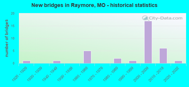
- New bridges - historical statistics
- 11920-1929
- 11940-1949
- 51960-1969
- 21980-1989
- 11990-1999
- 172000-2009
- 62010-2019
- 12020-2022
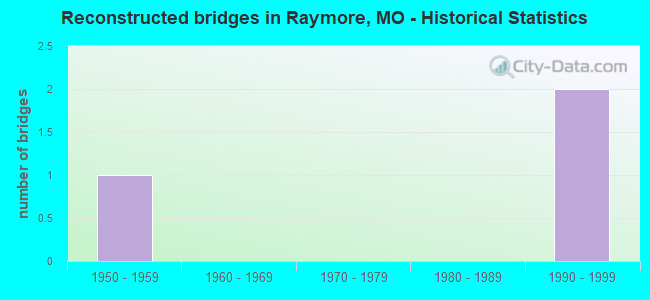
- Reconstructed bridges - Historical Statistics
- 11950-1959
- 01960-1969
- 01970-1979
- 01980-1989
- 21990-1999
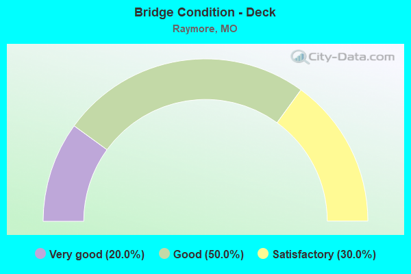
- Bridge Condition - Deck
- 20.0%Very good
- 50.0%Good
- 30.0%Satisfactory
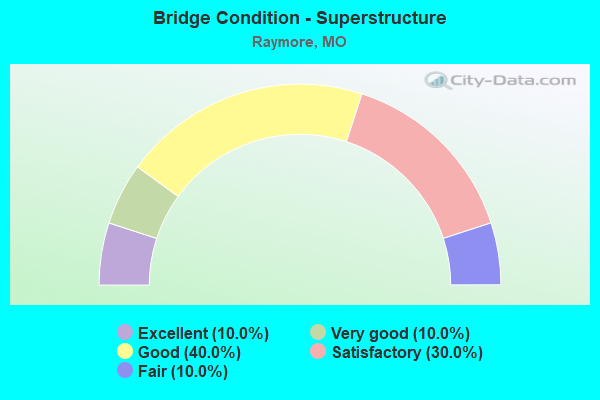
- Bridge Condition - Superstructure
- 10.0%Excellent
- 10.0%Very good
- 40.0%Good
- 30.0%Satisfactory
- 10.0%Fair
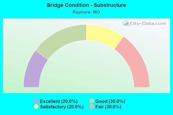
- Bridge Condition - Substructure
- 20.0%Excellent
- 30.0%Good
- 20.0%Satisfactory
- 30.0%Fair
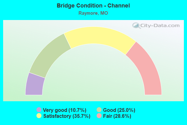
- Bridge Condition - Channel
- 10.7%Very good
- 25.0%Good
- 35.7%Satisfactory
- 28.6%Fair
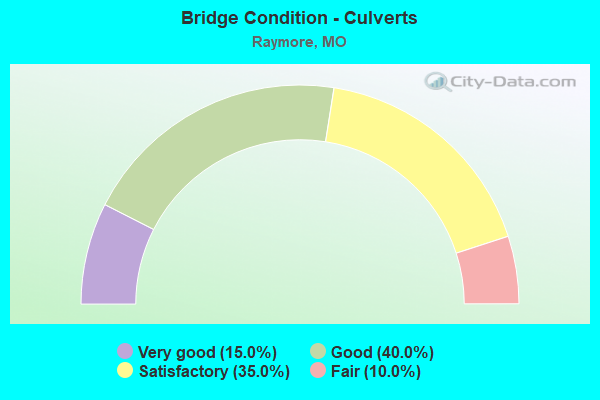
- Bridge Condition - Culverts
- 15.0%Very good
- 40.0%Good
- 35.0%Satisfactory
- 10.0%Fair
Find on map >> Show street view
Structure Number: 13334, Location: S 11 T 46 N R 32 W (Lat: 38.806042, Lng: -94.420214), Route carried "on" structure: County highway 35, Year Built: 1988, Status: Posted for load, Structure Length: 0.94m (3.08ft), Average Daily Traffic: 349 (year 2021), Truck Traffic: 5%, Average Future Daily Traffic: 558 (year 2041), Features Intersected: BR OF BIG CR, Facility Carried by Structure: PRAIRIE RD
Minimum Vertical Clearance: 30+ m (98+ ft), Kilometerpoint: 3.701, Lanes on structure: 1, Owner: County Highway Agency, Approaching Roadway Width: 6.7m (22.0ft), Material/Design: Steel, Design/Construction: Stringer/Multi-beam, Number Of Spans In Main Unit: 1, Length of Maximum Span: 9.1m (29.9ft), Curb-To-Curb Width: 7.3m (24.0ft), Out-to-Out Width: 7.3m (24.0ft)
Condition: Deck: Satisfactory, Superstructure: Fair, Substructure: Fair, Channel: Fair, Operating Rating: 16.2 metric tons, Method Used To Determine Operating Rating: Allowable Stress (AS), Inventory Rating: 8.1 metric tons, Method Used To Determine Inventory Rating: Allowable Stress (AS), Structural Evaluation: High priority of replacement, Deck Geometry: Somewhat better than minimum adequacy, Waterway Adequacy: Better than present minimum criteria, Approach Roadway Alignment: Equal to present desirable criteria, Bridge Posting: Required (Relationship of Operating Rating to Maximum Legal Load: 30.0 - 39.9% below), Length Of Structure Improvement: 0.16m (0.52ft), Designated Inspection Frequency: Every 24 months, Inspection Date: April 2021, Bridge Improvement Cost: $143,000, Roadway Improvement Cost: $14,000, Total Project Cost: $215,000 ( Estimate for 2022), Deck Structure Type: Concrete Cast-file-Place, Wearing Surface/Protective System: Wearing Surface: Monolithic Concrete
Find on map >> Show street view
Structure Number: 13398, Location: S 7 T 46 N R 31 W (Lat: 38.811786, Lng: -94.400983), Route carried "on" structure: County highway 37, Year Built: 1940, Year Reconstructed: 1995, Status: Open, Structure Length: 0.94m (3.08ft), Average Daily Traffic: 532 (year 2021), Truck Traffic: 5%, Average Future Daily Traffic: 851 (year 2041), Features Intersected: BR OF BIG CR, Facility Carried by Structure: WARD RD
Minimum Vertical Clearance: 30+ m (98+ ft), Kilometerpoint: 2.897, Lanes on structure: 2, Owner: City or Municipal Highway Agency, Approaching Roadway Width: 6.4m (21.0ft), Material/Design: Steel, Design/Construction: Stringer/Multi-beam, Number Of Spans In Main Unit: 1, Length of Maximum Span: 8.8m (28.9ft), Curb-To-Curb Width: 7.3m (24.0ft), Out-to-Out Width: 7.5m (24.6ft)
Condition: Deck: Good, Superstructure: Satisfactory, Substructure: Fair, Channel: Fair, Operating Rating: 89.1 metric tons, Method Used To Determine Operating Rating: Load Factor (LF), Inventory Rating: 46.8 metric tons, Method Used To Determine Inventory Rating: Load Factor (LF), Structural Evaluation: Somewhat better than minimum adequacy, Deck Geometry: Meets minimum limits, Waterway Adequacy: Better than present minimum criteria, Approach Roadway Alignment: Equal to present desirable criteria, Designated Inspection Frequency: Every 24 months, Inspection Date: March 2021, Deck Structure Type: Concrete Cast-file-Place, Wearing Surface/Protective System: Wearing Surface: Bituminous
Find on map >> Show street view
Structure Number: 13544, Location: S 30 T 46 N R 32 W (Lat: 38.769036, Lng: -94.494094), Route carried "on" structure: County highway 41, Year Built: 1965, Status: Posted for load, Structure Length: 3.23m (10.60ft), Average Daily Traffic: 205 (year 2021), Truck Traffic: 5%, Average Future Daily Traffic: 328 (year 2041), Design Load: HS 20, Features Intersected: BR OF W FK CR, Facility Carried by Structure: 195 ST
Minimum Vertical Clearance: 30+ m (98+ ft), Kilometerpoint: 1.609, Lanes on structure: 2, Owner: County Highway Agency, Approaching Roadway Width: 7.3m (24.0ft), Material/Design: Steel, Design/Construction: Stringer/Multi-beam, Number Of Spans In Main Unit: 3, Length of Maximum Span: 12.2m (40.0ft), Curb-To-Curb Width: 7.3m (24.0ft), Out-to-Out Width: 7.9m (25.9ft)
Condition: Deck: Good, Superstructure: Good, Substructure: Good, Channel: Fair, Operating Rating: 18.9 metric tons, Method Used To Determine Operating Rating: Allowable Stress (AS), Inventory Rating: 10.8 metric tons, Method Used To Determine Inventory Rating: Allowable Stress (AS), Structural Evaluation: Meets minimum limits, Deck Geometry: Somewhat better than minimum adequacy, Waterway Adequacy: Better than present minimum criteria, Approach Roadway Alignment: Equal to present desirable criteria, Designated Inspection Frequency: Every 24 months, Inspection Date: March 2021, Deck Structure Type: Concrete Cast-file-Place, Wearing Surface/Protective System: Wearing Surface: Monolithic Concrete
Find on map >> Show street view
Structure Number: 1751, Location: S 32 T 46 N R 32 W (Lat: 38.759711, Lng: -94.486092), Route carried "on" structure: Interstate 49, Year Built: 1968, Status: Open, Structure Length: 0.71m (2.33ft), Average Daily Traffic: 35,999 (year 2021), Truck Traffic: 20%, Average Future Daily Traffic: 62,998 (year 2041), Design Load: HS 20, Features Intersected: MILLERS HOLLOW CR
Minimum Vertical Clearance: 30+ m (98+ ft), Kilometerpoint: 21.633, Lanes on structure: 4, Base Highway Network: Yes, Owner: State Highway Agency, Approaching Roadway Width: 12.2m (40.0ft), Skew: 21 degrees, Material/Design: Concrete continuous, Design/Construction: Culvert, Number Of Spans In Main Unit: 2, Length of Maximum Span: 3.4m (11.2ft)
Condition: Channel: Fair, Culverts: Satisfactory, Inventory Rating: 69.3 metric tons, Method Used To Determine Inventory Rating: Load Factor (LF), Structural Evaluation: Equal to present minimum criteria, Waterway Adequacy: Equal to present minimum criteria, Approach Roadway Alignment: Equal to present desirable criteria, Designated Inspection Frequency: Every 24 months, Inspection Date: November 2021
Find on map >> Show street view
Structure Number: 1778, Location: S 7 T 46 N R 32 W (Lat: 38.813319, Lng: -94.503872), Route carried "on" structure: State highway 58, Year Built: 1968, Year Reconstructed: 1990, Status: Posted for load, Structure Length: 8.38m (27.49ft), Average Daily Traffic: 29,522 (year 2021), Truck Traffic: 4%, Average Future Daily Traffic: 54,616 (year 2041), Design Load: HS 20+Mod, Features Intersected: IS 49
Minimum Vertical Clearance: 30+ m (98+ ft), Kilometerpoint: 7.166, Lanes on structure: 5, Lanes under structure: 4, Owner: State Highway Agency, Approaching Roadway Width: 22.9m (75.1ft), Skew: 3 degrees, Material/Design: Steel continuous, Design/Construction: Stringer/Multi-beam, Number Of Spans In Main Unit: 4, Length of Maximum Span: 25.6m (84.0ft), Curb or Sidewalk Widths: Left: 1.5m (4.9ft), Right: 1.5m (4.9ft), Curb-To-Curb Width: 18.8m (61.7ft), Out-to-Out Width: 23.5m (77.1ft)
Condition: Deck: Satisfactory, Superstructure: Satisfactory, Substructure: Fair, Operating Rating: 54.9 metric tons, Method Used To Determine Operating Rating: Load Factor (LF), Inventory Rating: 33.3 metric tons, Method Used To Determine Inventory Rating: Load Factor (LF), Structural Evaluation: Somewhat better than minimum adequacy, Deck Geometry: Meets minimum limits, Underclear: Meets minimum limits, Approach Roadway Alignment: Equal to present desirable criteria, Designated Inspection Frequency: Every 24 months, Inspection Date: November 2021, Deck Structure Type: Concrete Cast-file-Place, Wearing Surface/Protective System: Wearing Surface: Monolithic Concrete, Deck Protection: Epoxy Coated Reinforcing
Find on map >> Show street view
Structure Number: 31212, Location: S 28 T 46 N R 32 W (Lat: 38.782444, Lng: -94.463222), Route carried "on" structure: County highway 43, Year Built: 2006, Status: Open, Structure Length: 0.73m (2.40ft), Average Daily Traffic: 50 (year 2021), Truck Traffic: 10%, Average Future Daily Traffic: 80 (year 2041), Design Load: HS 20, Features Intersected: TRIB TO EAST CR, Facility Carried by Structure: HUBACH HILL RD
Minimum Vertical Clearance: 30+ m (98+ ft), Kilometerpoint: 0.000, Lanes on structure: 2, Owner: County Highway Agency, Approaching Roadway Width: 7.3m (24.0ft), Material/Design: Concrete continuous, Design/Construction: Slab, Number Of Spans In Main Unit: 3, Length of Maximum Span: 2.4m (7.9ft), Curb-To-Curb Width: 7.3m (24.0ft), Out-to-Out Width: 13.7m (44.9ft)
Condition: Deck: Good, Superstructure: Good, Substructure: Good, Channel: Satisfactory, Operating Rating: 57.6 metric tons, Method Used To Determine Operating Rating: Load Factor (LF), Inventory Rating: 34.2 metric tons, Method Used To Determine Inventory Rating: Load Factor (LF), Structural Evaluation: Better than present minimum criteria, Deck Geometry: Equal to present minimum criteria, Waterway Adequacy: Better than present minimum criteria, Approach Roadway Alignment: Equal to present desirable criteria, Designated Inspection Frequency: Every 24 months, Inspection Date: April 2021, Deck Structure Type: Concrete Cast-file-Place, Wearing Surface/Protective System: Wearing Surface: Bituminous
Find on map >> Show street view
Structure Number: 31915, Location: S 17 T 46 N R 32 W (Lat: 38.798250, Lng: -94.482861), Route carried "on" structure: City street , Year Built: 2006, Status: Open, Structure Length: 1.92m (6.30ft), Average Daily Traffic: 4,400 (year 2021), Truck Traffic: 5%, Average Future Daily Traffic: 7,040 (year 2041), Features Intersected: TRIBUTARY, Facility Carried by Structure: FOX RIDGE DR
Minimum Vertical Clearance: 30+ m (98+ ft), Kilometerpoint: 0.000, Lanes on structure: 3, Owner: City or Municipal Highway Agency, Approaching Roadway Width: 12.2m (40.0ft), Skew: 3 degrees, Material/Design: Concrete continuous, Design/Construction: Culvert, Number Of Spans In Main Unit: 5, Length of Maximum Span: 4.0m (13.1ft)
Condition: Channel: Satisfactory, Culverts: Satisfactory, Operating Rating: 54.0 metric tons, Method Used To Determine Operating Rating: Load Factor (LF), Inventory Rating: 32.4 metric tons, Method Used To Determine Inventory Rating: Load Factor (LF), Structural Evaluation: Equal to present minimum criteria, Waterway Adequacy: Better than present minimum criteria, Approach Roadway Alignment: Equal to present desirable criteria, Designated Inspection Frequency: Every 24 months, Inspection Date: March 2021
Find on map >> Show street view
Structure Number: 31916, Location: S 17 T 46 N R 32 W (Lat: 38.797847, Lng: -94.483525), Route carried "on" structure: City street , Year Built: 2006, Status: Open, Structure Length: 1.49m (4.89ft), Average Daily Traffic: 7,800 (year 2021), Truck Traffic: 5%, Average Future Daily Traffic: 12,480 (year 2041), Features Intersected: TRIBUTARY, Facility Carried by Structure: LUCY WEBB RD
Minimum Vertical Clearance: 30+ m (98+ ft), Kilometerpoint: 0.000, Lanes on structure: 3, Owner: City or Municipal Highway Agency, Approaching Roadway Width: 12.2m (40.0ft), Skew: 3 degrees, Material/Design: Concrete continuous, Design/Construction: Culvert, Number Of Spans In Main Unit: 5, Length of Maximum Span: 4.0m (13.1ft)
Condition: Channel: Good, Culverts: Good, Operating Rating: 54.0 metric tons, Method Used To Determine Operating Rating: Load Factor (LF), Inventory Rating: 32.4 metric tons, Method Used To Determine Inventory Rating: Load Factor (LF), Structural Evaluation: Better than present minimum criteria, Waterway Adequacy: Better than present minimum criteria, Approach Roadway Alignment: Equal to present desirable criteria, Designated Inspection Frequency: Every 24 months, Inspection Date: March 2021
Find on map >> Show street view
Structure Number: 31918, Location: S 17 T 46 N R 33 W (Lat: 38.797847, Lng: -94.485422), Route carried "on" structure: City street , Year Built: 2006, Status: Open, Structure Length: 2.44m (8.01ft), Average Daily Traffic: 7,800 (year 2021), Truck Traffic: 5%, Average Future Daily Traffic: 12,480 (year 2041), Features Intersected: TRIBUTARY, Facility Carried by Structure: LUCY WEBB RD
Minimum Vertical Clearance: 30+ m (98+ ft), Kilometerpoint: 0.000, Lanes on structure: 2, Owner: City or Municipal Highway Agency, Approaching Roadway Width: 9.1m (29.9ft), Skew: 4 degrees, Material/Design: Concrete continuous, Design/Construction: Culvert, Number Of Spans In Main Unit: 4, Length of Maximum Span: 3.4m (11.2ft)
Condition: Channel: Satisfactory, Culverts: Good, Operating Rating: 54.0 metric tons, Method Used To Determine Operating Rating: Load Factor (LF), Inventory Rating: 32.4 metric tons, Method Used To Determine Inventory Rating: Load Factor (LF), Structural Evaluation: Better than present minimum criteria, Waterway Adequacy: Better than present minimum criteria, Approach Roadway Alignment: Equal to present desirable criteria, Designated Inspection Frequency: Every 24 months, Inspection Date: March 2021
Find on map >> Show street view
Structure Number: 31919, Location: S 17 T 46 N R 32 W (Lat: 38.806894, Lng: -94.479664), Route carried "on" structure: City street , Year Built: 2006, Status: Open, Structure Length: 0.94m (3.08ft), Average Daily Traffic: 4,400 (year 2021), Truck Traffic: 5%, Average Future Daily Traffic: 7,040 (year 2041), Features Intersected: TRIB OF SILVER LK, Facility Carried by Structure: FOX RIDGE DR
Minimum Vertical Clearance: 30+ m (98+ ft), Kilometerpoint: 0.000, Lanes on structure: 4, Owner: City or Municipal Highway Agency, Approaching Roadway Width: 14.0m (45.9ft), Skew: 4 degrees, Material/Design: Concrete continuous, Design/Construction: Culvert, Number Of Spans In Main Unit: 2, Length of Maximum Span: 4.3m (14.1ft)
Condition: Channel: Satisfactory, Culverts: Satisfactory, Operating Rating: 54.0 metric tons, Method Used To Determine Operating Rating: Load Factor (LF), Inventory Rating: 32.4 metric tons, Method Used To Determine Inventory Rating: Load Factor (LF), Structural Evaluation: Equal to present minimum criteria, Waterway Adequacy: Equal to present desirable criteria, Approach Roadway Alignment: Equal to present desirable criteria, Designated Inspection Frequency: Every 24 months, Inspection Date: March 2021
Find on map >> Show street view
Structure Number: 3192, Location: S 17 T 46 N R 32 W (Lat: 38.804850, Lng: -94.479539), Route carried "on" structure: City street , Year Built: 2006, Status: Open, Structure Length: 1.55m (5.09ft), Average Daily Traffic: 4,400 (year 2021), Truck Traffic: 5%, Average Future Daily Traffic: 7,040 (year 2041), Design Load: HS 20+Mod, Features Intersected: TRIB OF SILVER LK, Facility Carried by Structure: JOHNSON DR
Minimum Vertical Clearance: 30+ m (98+ ft), Kilometerpoint: 0.000, Lanes on structure: 2, Owner: City or Municipal Highway Agency, Approaching Roadway Width: 10.4m (34.1ft), Material/Design: Concrete continuous, Design/Construction: Culvert, Number Of Spans In Main Unit: 4, Length of Maximum Span: 3.0m (9.8ft)
Condition: Channel: Very good, Culverts: Satisfactory, Operating Rating: 38.7 metric tons, Method Used To Determine Operating Rating: Load Factor (LF), Inventory Rating: 23.4 metric tons, Method Used To Determine Inventory Rating: Load Factor (LF), Structural Evaluation: Equal to present minimum criteria, Waterway Adequacy: Better than present minimum criteria, Approach Roadway Alignment: Equal to present desirable criteria, Designated Inspection Frequency: Every 24 months, Inspection Date: March 2021
Find on map >> Show street view
Structure Number: 31921, Location: S 17 T 46 N R 32 W (Lat: 38.801197, Lng: -94.476100), Route carried "on" structure: City street , Year Built: 1990, Status: Open, Structure Length: 1.22m (4.00ft), Average Daily Traffic: 200 (year 2021), Truck Traffic: 2%, Average Future Daily Traffic: 320 (year 2041), Design Load: HS 20, Features Intersected: SILVER LAKE OVRFL, Facility Carried by Structure: SILVER TOP DR
Minimum Vertical Clearance: 30+ m (98+ ft), Kilometerpoint: 0.000, Lanes on structure: 2, Owner: City or Municipal Highway Agency, Approaching Roadway Width: 7.3m (24.0ft), Material/Design: Concrete continuous, Design/Construction: Culvert, Number Of Spans In Main Unit: 3, Length of Maximum Span: 3.7m (12.1ft)
Condition: Channel: Good, Culverts: Fair, Operating Rating: 54.0 metric tons, Method Used To Determine Operating Rating: Load Factor (LF), Inventory Rating: 32.4 metric tons, Method Used To Determine Inventory Rating: Load Factor (LF), Structural Evaluation: Somewhat better than minimum adequacy, Waterway Adequacy: Superior to present desirable criteria, Approach Roadway Alignment: Equal to present desirable criteria, Designated Inspection Frequency: Every 24 months, Inspection Date: March 2021
Find on map >> Show street view
Structure Number: 31922, Location: S 29 T 46 N R 32 W (Lat: 38.783025, Lng: -94.480156), Route carried "on" structure: City street , Year Built: 2006, Status: Open, Structure Length: 1.40m (4.59ft), Average Daily Traffic: 50 (year 2021), Truck Traffic: 5%, Average Future Daily Traffic: 80 (year 2041), Features Intersected: TRIBUTARY, Facility Carried by Structure: HUBACH HILL RD
Minimum Vertical Clearance: 30+ m (98+ ft), Kilometerpoint: 0.000, Lanes on structure: 2, Owner: City or Municipal Highway Agency, Approaching Roadway Width: 9.8m (32.2ft), Material/Design: Steel, Design/Construction: Culvert, Number Of Spans In Main Unit: 2, Length of Maximum Span: 6.7m (22.0ft)
Condition: Channel: Fair, Culverts: Satisfactory, Operating Rating: 54.0 metric tons, Method Used To Determine Operating Rating: Load Factor (LF), Inventory Rating: 32.4 metric tons, Method Used To Determine Inventory Rating: Load Factor (LF), Structural Evaluation: Equal to present minimum criteria, Waterway Adequacy: Better than present minimum criteria, Approach Roadway Alignment: Equal to present desirable criteria, Designated Inspection Frequency: Every 24 months, Inspection Date: March 2021
Find on map >> Show street view
Structure Number: 31924, Location: S 20 T 46 N R 32 W (Lat: 38.790033, Lng: -94.484317), Route carried "on" structure: City street , Year Built: 2006, Status: Open, Structure Length: 1.01m (3.31ft), Average Daily Traffic: 30 (year 2021), Truck Traffic: 2%, Average Future Daily Traffic: 48 (year 2041), Features Intersected: TRIB OF SILVER LK, Facility Carried by Structure: FOXRIDGE DR
Minimum Vertical Clearance: 30+ m (98+ ft), Kilometerpoint: 0.000, Lanes on structure: 2, Owner: City or Municipal Highway Agency, Approaching Roadway Width: 11.0m (36.1ft), Material/Design: Concrete, Design/Construction: Culvert, Number Of Spans In Main Unit: 1, Length of Maximum Span: 10.1m (33.1ft)
Condition: Channel: Fair, Culverts: Fair, Operating Rating: 54.0 metric tons, Method Used To Determine Operating Rating: Load Factor (LF), Inventory Rating: 32.4 metric tons, Method Used To Determine Inventory Rating: Load Factor (LF), Structural Evaluation: Somewhat better than minimum adequacy, Waterway Adequacy: Better than present minimum criteria, Approach Roadway Alignment: Equal to present desirable criteria, Designated Inspection Frequency: Every 24 months, Inspection Date: March 2021
Find on map >> Show street view
Structure Number: 31925, Location: S 29 T 46 N R 32 W (Lat: 38.770814, Lng: -94.490494), Route carried "on" structure: City street , Year Built: 2006, Status: Open, Structure Length: 1.40m (4.59ft), Average Daily Traffic: 20 (year 2021), Truck Traffic: 5%, Average Future Daily Traffic: 32 (year 2041), Features Intersected: BR OF EAST CR, Facility Carried by Structure: OWEN GOOD PUMP RD
Minimum Vertical Clearance: 30+ m (98+ ft), Kilometerpoint: 0.000, Lanes on structure: 2, Owner: City or Municipal Highway Agency, Approaching Roadway Width: 4.6m (15.1ft), Material/Design: Concrete continuous, Design/Construction: Slab, Number Of Spans In Main Unit: 3, Length of Maximum Span: 4.3m (14.1ft), Curb-To-Curb Width: 6.7m (22.0ft), Out-to-Out Width: 6.7m (22.0ft)
Condition: Deck: Good, Superstructure: Good, Substructure: Good, Channel: Satisfactory, Operating Rating: 54.0 metric tons, Method Used To Determine Operating Rating: Load Factor (LF), Inventory Rating: 32.4 metric tons, Method Used To Determine Inventory Rating: Allowable Stress (AS), Structural Evaluation: Better than present minimum criteria, Deck Geometry: Somewhat better than minimum adequacy, Waterway Adequacy: Better than present minimum criteria, Approach Roadway Alignment: Equal to present desirable criteria, Designated Inspection Frequency: Every 24 months, Inspection Date: March 2021, Deck Structure Type: Concrete Cast-file-Place, Wearing Surface/Protective System: Wearing Surface: Monolithic Concrete
Find on map >> Show street view
Structure Number: 31926, Location: S 8 T 46 N R 32 W (Lat: 38.825442, Lng: -94.477283), Route carried "on" structure: City street , Year Built: 2006, Status: Open, Structure Length: 0.79m (2.59ft), Average Daily Traffic: 50 (year 2021), Truck Traffic: 2%, Average Future Daily Traffic: 80 (year 2041), Design Load: HS 20+Mod, Features Intersected: CREEKMOORE LK OVRF, Facility Carried by Structure: 163RD ST
Minimum Vertical Clearance: 30+ m (98+ ft), Kilometerpoint: 0.000, Lanes on structure: 3, Owner: City or Municipal Highway Agency, Approaching Roadway Width: 12.5m (41.0ft), Material/Design: Concrete continuous, Design/Construction: Culvert, Number Of Spans In Main Unit: 2, Length of Maximum Span: 3.7m (12.1ft)
Condition: Channel: Satisfactory, Culverts: Good, Operating Rating: 53.1 metric tons, Method Used To Determine Operating Rating: Load Factor (LF), Inventory Rating: 31.5 metric tons, Method Used To Determine Inventory Rating: Load Factor (LF), Structural Evaluation: Better than present minimum criteria, Waterway Adequacy: Better than present minimum criteria, Approach Roadway Alignment: Equal to present desirable criteria, Designated Inspection Frequency: Every 24 months, Inspection Date: March 2021
Find on map >> Show street view
Structure Number: 31927, Location: S 5 T 46 N R 32 W (Lat: 38.832767, Lng: -94.475908), Route carried "on" structure: City street , Year Built: 2006, Status: Open, Structure Length: 0.70m (2.30ft), Average Daily Traffic: 50 (year 2021), Truck Traffic: 5%, Average Future Daily Traffic: 80 (year 2041), Design Load: HS 20+Mod, Features Intersected: TRIB OF CREEKMOOR, Facility Carried by Structure: CREEKMOOR DR
Minimum Vertical Clearance: 30+ m (98+ ft), Kilometerpoint: 0.000, Lanes on structure: 2, Owner: City or Municipal Highway Agency, Approaching Roadway Width: 9.1m (29.9ft), Skew: 2 degrees, Material/Design: Concrete continuous, Design/Construction: Culvert, Number Of Spans In Main Unit: 2, Length of Maximum Span: 3.0m (9.8ft)
Condition: Channel: Satisfactory, Culverts: Satisfactory, Operating Rating: 36.9 metric tons, Method Used To Determine Operating Rating: Load Factor (LF), Inventory Rating: 22.5 metric tons, Method Used To Determine Inventory Rating: Load Factor (LF), Structural Evaluation: Equal to present minimum criteria, Waterway Adequacy: Better than present minimum criteria, Approach Roadway Alignment: Equal to present desirable criteria, Designated Inspection Frequency: Every 24 months, Inspection Date: March 2021
Find on map >> Show street view
Structure Number: 31928, Location: S 4 T 46 N R 32 W (Lat: 38.831425, Lng: -94.481344), Route carried "on" structure: City street , Year Built: 2006, Status: Open, Structure Length: 1.74m (5.71ft), Average Daily Traffic: 2,750 (year 2021), Truck Traffic: 2%, Average Future Daily Traffic: 4,400 (year 2041), Design Load: HS 20+Mod, Features Intersected: TRIB OF CREEKMOOR, Facility Carried by Structure: FOX RIDGE DR
Minimum Vertical Clearance: 30+ m (98+ ft), Kilometerpoint: 0.000, Lanes on structure: 2, Owner: City or Municipal Highway Agency, Approaching Roadway Width: 4.3m (14.1ft), Skew: 22 degrees, Material/Design: Concrete continuous, Design/Construction: Culvert, Number Of Spans In Main Unit: 3, Length of Maximum Span: 4.9m (16.1ft)
Condition: Channel: Satisfactory, Culverts: Satisfactory, Operating Rating: 49.5 metric tons, Method Used To Determine Operating Rating: Load Factor (LF), Inventory Rating: 29.7 metric tons, Method Used To Determine Inventory Rating: Load Factor (LF), Structural Evaluation: Equal to present minimum criteria, Waterway Adequacy: Better than present minimum criteria, Approach Roadway Alignment: Equal to present desirable criteria, Designated Inspection Frequency: Every 24 months, Inspection Date: March 2021
Find on map >> Show street view
Structure Number: 3193, Location: S 23 T 57 N R 24 W (Lat: 39.732942, Lng: -93.555578), Route carried "on" structure: US 65, Year Built: 1983, Status: Open, Structure Length: 6.89m (22.60ft), Average Daily Traffic: 3,421 (year 2021), Truck Traffic: 11%, Average Future Daily Traffic: 5,987 (year 2041), Design Load: HS 20+Mod, Features Intersected: SHOAL CR
Minimum Vertical Clearance: 30+ m (98+ ft), Kilometerpoint: 100.901, Lanes on structure: 2, Base Highway Network: Yes, Owner: State Highway Agency, Approaching Roadway Width: 13.4m (44.0ft), Skew: 1 degrees, Material/Design: Prestressed concrete continuous, Design/Construction: Stringer/Multi-beam, Number Of Spans In Main Unit: 3, Length of Maximum Span: 23.0m (75.5ft), Curb or Sidewalk Widths: Left: 0.2m (0.7ft), Right: 0.2m (0.7ft), Curb-To-Curb Width: 13.4m (44.0ft), Out-to-Out Width: 14.5m (47.6ft)
Condition: Deck: Good, Superstructure: Good, Substructure: Satisfactory, Channel: Satisfactory, Operating Rating: 69.3 metric tons, Method Used To Determine Operating Rating: Load Factor (LF), Inventory Rating: 36.9 metric tons, Method Used To Determine Inventory Rating: Load Factor (LF), Structural Evaluation: Equal to present minimum criteria, Deck Geometry: Better than present minimum criteria, Waterway Adequacy: Equal to present desirable criteria, Approach Roadway Alignment: Equal to present desirable criteria, Designated Inspection Frequency: Every 24 months, Inspection Date: October 2020, Deck Structure Type: Concrete Cast-file-Place, Wearing Surface/Protective System: Wearing Surface: Monolithic Concrete, Deck Protection: Epoxy Coated Reinforcing
Find on map >> Show street view
Structure Number: 3193, Location: S 5 T 46 N R 32 W (Lat: 38.835211, Lng: -94.478750), Route carried "on" structure: City street , Year Built: 2006, Status: Open, Structure Length: 0.88m (2.89ft), Average Daily Traffic: 60 (year 2021), Truck Traffic: 5%, Average Future Daily Traffic: 96 (year 2041), Design Load: HS 20, Features Intersected: TRIB OF CREEKMOOR, Facility Carried by Structure: CROSS CREEK DR
Minimum Vertical Clearance: 30+ m (98+ ft), Kilometerpoint: 0.000, Lanes on structure: 2, Owner: City or Municipal Highway Agency, Approaching Roadway Width: 8.5m (27.9ft), Material/Design: Concrete continuous, Design/Construction: Culvert, Number Of Spans In Main Unit: 2, Length of Maximum Span: 4.0m (13.1ft)
Condition: Channel: Fair, Culverts: Good, Operating Rating: 54.0 metric tons, Method Used To Determine Operating Rating: Load Factor (LF), Inventory Rating: 32.4 metric tons, Method Used To Determine Inventory Rating: Load Factor (LF), Structural Evaluation: Better than present minimum criteria, Waterway Adequacy: Equal to present desirable criteria, Approach Roadway Alignment: Equal to present desirable criteria, Designated Inspection Frequency: Every 24 months, Inspection Date: March 2021
Find on map >> Show street view
Structure Number: 31982, Location: S 5 T 46 N R 32 W (Lat: 38.834706, Lng: -94.481472), Route carried "on" structure: City street , Year Built: 2006, Status: Open, Structure Length: 0.67m (2.20ft), Average Daily Traffic: 2,750 (year 2021), Truck Traffic: 5%, Average Future Daily Traffic: 4,400 (year 2041), Design Load: HS 20+Mod, Features Intersected: TRIB OF CREEKMOOR, Facility Carried by Structure: FOX RIDGE DR
Minimum Vertical Clearance: 30+ m (98+ ft), Kilometerpoint: 0.000, Lanes on structure: 2, Owner: City or Municipal Highway Agency, Approaching Roadway Width: 4.3m (14.1ft), Skew: 20 degrees, Material/Design: Concrete continuous, Design/Construction: Culvert, Number Of Spans In Main Unit: 2, Length of Maximum Span: 3.0m (9.8ft)
Condition: Channel: Satisfactory, Culverts: Good, Operating Rating: 45.9 metric tons, Method Used To Determine Operating Rating: Load Factor (LF), Inventory Rating: 27.9 metric tons, Method Used To Determine Inventory Rating: Load Factor (LF), Structural Evaluation: Better than present minimum criteria, Waterway Adequacy: Better than present minimum criteria, Approach Roadway Alignment: Equal to present desirable criteria, Designated Inspection Frequency: Every 24 months, Inspection Date: March 2021
Find on map >> Show street view
Structure Number: 32792, Location: S 19 T 46 N R 32 W (Lat: 38.786075, Lng: -94.497075), Route carried "on" structure: City street , Year Built: 2008, Status: Open, Structure Length: 5.64m (18.50ft), Average Daily Traffic: 4,428 (year 2020), Truck Traffic: 5%, Average Future Daily Traffic: 7,306 (year 2040), Design Load: HS 20, Features Intersected: IS 49, Facility Carried by Structure: NORTH CASS PKWY E
Minimum Vertical Clearance: 30+ m (98+ ft), Kilometerpoint: 0.489, Lanes on structure: 6, Lanes under structure: 4, Owner: State Highway Agency, Approaching Roadway Width: 25.0m (82.0ft), Material/Design: Prestressed concrete continuous, Design/Construction: Stringer/Multi-beam, Number Of Spans In Main Unit: 2, Length of Maximum Span: 27.7m (90.9ft), Curb or Sidewalk Widths: Left: 0.0m, Right: 0.4m (1.3ft), Curb-To-Curb Width: 25.0m (82.0ft), Out-to-Out Width: 29.1m (95.5ft)
Condition: Deck: Very good, Superstructure: Very good, Substructure: Excellent, Operating Rating: 87.3 metric tons, Method Used To Determine Operating Rating: Load Factor (LF), Inventory Rating: 43.2 metric tons, Method Used To Determine Inventory Rating: Load Factor (LF), Structural Evaluation: Equal to present desirable criteria, Deck Geometry: Somewhat better than minimum adequacy, Underclear: Somewhat better than minimum adequacy, Approach Roadway Alignment: Equal to present desirable criteria, Designated Inspection Frequency: Every 24 months, Inspection Date: November 2021, Deck Structure Type: Concrete Cast-file-Place, Wearing Surface/Protective System: Wearing Surface: Monolithic Concrete, Deck Protection: Epoxy Coated Reinforcing
Find on map >> Show street view
Structure Number: 34984, Location: S 21 T 46 N R 32 W (Lat: 38.786056, Lng: -94.459583), Route carried "on" structure: County highway 698, Year Built: 2010, Status: Open, Structure Length: 0.90m (2.95ft), Average Daily Traffic: 100 (year 2021), Truck Traffic: 10%, Average Future Daily Traffic: 160 (year 2041), Design Load: HS 20, Features Intersected: UNNAMED CR, Facility Carried by Structure: MAGNOLIA ST
Minimum Vertical Clearance: 30+ m (98+ ft), Kilometerpoint: 1.287, Lanes on structure: 2, Owner: County Highway Agency, Approaching Roadway Width: 7.3m (24.0ft), Skew: 3 degrees, Material/Design: Aluminum, Iron, Design/Construction: Culvert, Number Of Spans In Main Unit: 1, Length of Maximum Span: 9.0m (29.5ft)
Condition: Channel: Good, Culverts: Very good, Operating Rating: 54.0 metric tons, Method Used To Determine Operating Rating: Field evaluation and documented engineering judgment, Inventory Rating: 32.4 metric tons, Method Used To Determine Inventory Rating: Field evaluation and documented engineering judgment, Structural Evaluation: Equal to present desirable criteria, Waterway Adequacy: Equal to present minimum criteria, Approach Roadway Alignment: Equal to present desirable criteria, Designated Inspection Frequency: Every 24 months, Inspection Date: April 2021
Find on map >> Show street view
Structure Number: 34985, Location: S 36 T 45 N R 32 W (Lat: 38.759444, Lng: -94.422139), Route carried "on" structure: County highway 53, Year Built: 2014, Status: Open, Structure Length: 0.73m (2.40ft), Average Daily Traffic: 100 (year 2021), Truck Traffic: 10%, Average Future Daily Traffic: 160 (year 2041), Design Load: HS 20, Features Intersected: BR OF WOLF CR, Facility Carried by Structure: PRAIRIE RD
Minimum Vertical Clearance: 30+ m (98+ ft), Kilometerpoint: 0.805, Lanes on structure: 2, Owner: County Highway Agency, Approaching Roadway Width: 7.9m (25.9ft), Material/Design: Aluminum, Iron, Design/Construction: Culvert, Number Of Spans In Main Unit: 1, Length of Maximum Span: 7.3m (24.0ft)
Condition: Channel: Good, Culverts: Good, Operating Rating: 54.0 metric tons, Method Used To Determine Operating Rating: Field evaluation and documented engineering judgment, Inventory Rating: 32.4 metric tons, Method Used To Determine Inventory Rating: Field evaluation and documented engineering judgment, Structural Evaluation: Better than present minimum criteria, Waterway Adequacy: Equal to present minimum criteria, Approach Roadway Alignment: Equal to present desirable criteria, Designated Inspection Frequency: Every 24 months, Inspection Date: April 2021
Find on map >> Show street view
Structure Number: 35015, Location: S 20 T 46 N R 32 W (Lat: 38.784222, Lng: -94.486944), Route carried "on" structure: City street , Year Built: 2010, Status: Open, Structure Length: 1.02m (3.35ft), Average Daily Traffic: 1,000 (year 2021), Truck Traffic: 10%, Average Future Daily Traffic: 1,600 (year 2041), Design Load: HS 20, Features Intersected: TRIB SILVER LAKE, Facility Carried by Structure: N CASS PKWY
Minimum Vertical Clearance: 30+ m (98+ ft), Kilometerpoint: 0.000, Lanes on structure: 3, Owner: City or Municipal Highway Agency, Approaching Roadway Width: 13.2m (43.3ft), Skew: 3 degrees, Material/Design: Concrete continuous, Design/Construction: Culvert, Number Of Spans In Main Unit: 2, Length of Maximum Span: 4.3m (14.1ft)
Condition: Channel: Very good, Culverts: Good, Operating Rating: 72.0 metric tons, Method Used To Determine Operating Rating: Load Factor (LF), Inventory Rating: 43.2 metric tons, Method Used To Determine Inventory Rating: Load Factor (LF), Structural Evaluation: Better than present minimum criteria, Waterway Adequacy: Equal to present desirable criteria, Approach Roadway Alignment: Equal to present desirable criteria, Designated Inspection Frequency: Every 24 months, Inspection Date: March 2021
Find on map >> Show street view
Structure Number: 35016, Location: S 29 T 46 N R 32 W (Lat: 38.781444, Lng: -94.481639), Route carried "on" structure: City street , Year Built: 2010, Status: Open, Structure Length: 1.81m (5.94ft), Average Daily Traffic: 1 (year 2021), Truck Traffic: 5%, Average Future Daily Traffic: 2 (year 2041), Design Load: HS 20, Features Intersected: TRIB SILVER LAKE, Facility Carried by Structure: N CASS PKWY 2
Minimum Vertical Clearance: 30+ m (98+ ft), Kilometerpoint: 0.000, Lanes on structure: 2, Owner: City or Municipal Highway Agency, Approaching Roadway Width: 13.6m (44.6ft), Skew: 2 degrees, Material/Design: Concrete continuous, Design/Construction: Culvert, Number Of Spans In Main Unit: 3, Length of Maximum Span: 5.5m (18.0ft)
Condition: Channel: Very good, Culverts: Good, Operating Rating: 54.0 metric tons, Method Used To Determine Operating Rating: Load Factor (LF), Inventory Rating: 32.4 metric tons, Method Used To Determine Inventory Rating: Load Factor (LF), Structural Evaluation: Better than present minimum criteria, Waterway Adequacy: Better than present minimum criteria, Approach Roadway Alignment: Equal to present desirable criteria, Designated Inspection Frequency: Every 24 months, Inspection Date: March 2021
Find on map >> Show street view
Structure Number: 36128, Location: S 3 T 46 N R 32 W (Lat: 38.840389, Lng: -94.449056), Route carried "on" structure: City street , Year Built: 2018, Status: Open, Structure Length: 0.70m (2.30ft), Average Daily Traffic: 1,600 (year 2021), Truck Traffic: 10%, Average Future Daily Traffic: 2,560 (year 2041), Features Intersected: LUMPKIN'S FK, Facility Carried by Structure: 155TH ST
Minimum Vertical Clearance: 30+ m (98+ ft), Kilometerpoint: 3.058, Lanes on structure: 2, Owner: City or Municipal Highway Agency, Approaching Roadway Width: 7.3m (24.0ft), Material/Design: Concrete, Design/Construction: Culvert, Number Of Spans In Main Unit: 2, Length of Maximum Span: 3.0m (9.8ft)
Condition: Channel: Good, Culverts: Very good, Operating Rating: 77.4 metric tons, Method Used To Determine Operating Rating: Load Factor (LF), Inventory Rating: 46.8 metric tons, Method Used To Determine Inventory Rating: Load Factor (LF), Structural Evaluation: Equal to present desirable criteria, Waterway Adequacy: Superior to present desirable criteria, Approach Roadway Alignment: Equal to present desirable criteria, Designated Inspection Frequency: Every 24 months, Inspection Date: March 2021
Find on map >> Show street view
Structure Number: 36134, Location: S 20 T 46 N R 32 W (Lat: 38.789556, Lng: -94.487528), Route carried "on" structure: City street 361, Year Built: 2019, Status: Open, Structure Length: 1.40m (4.59ft), Average Daily Traffic: 40 (year 2021), Truck Traffic: 5%, Average Future Daily Traffic: 64 (year 2041), Features Intersected: TRIB OF SILVER LK, Facility Carried by Structure: S FOX RIDGE DR
Minimum Vertical Clearance: 30+ m (98+ ft), Kilometerpoint: 3.219, Lanes on structure: 2, Owner: City or Municipal Highway Agency, Approaching Roadway Width: 10.1m (33.1ft), Skew: 1 degrees, Material/Design: Concrete, Design/Construction: Culvert, Number Of Spans In Main Unit: 3, Length of Maximum Span: 4.3m (14.1ft)
Condition: Channel: Good, Culverts: Very good, Operating Rating: 96.3 metric tons, Method Used To Determine Operating Rating: Load Factor (LF), Inventory Rating: 57.6 metric tons, Method Used To Determine Inventory Rating: Load Factor (LF), Structural Evaluation: Equal to present desirable criteria, Waterway Adequacy: Superior to present desirable criteria, Approach Roadway Alignment: Equal to present desirable criteria, Designated Inspection Frequency: Every 24 months, Inspection Date: March 2021
Find on map >> Show street view
Structure Number: 36514, Location: S 29 T 46 N R 32 W (Lat: 38.770900, Lng: -94.492661), Route carried "on" structure: County highway , Year Built: 2021, Status: Open, Structure Length: 4.62m (15.16ft), Average Daily Traffic: 1,628 (year 2020), Truck Traffic: 5%, Average Future Daily Traffic: 2,686 (year 2040), Features Intersected: EAST CR, Facility Carried by Structure: PECULIAR DR S
Minimum Vertical Clearance: 30+ m (98+ ft), Kilometerpoint: 5.531, Lanes on structure: 2, Owner: State Highway Agency, Approaching Roadway Width: 8.5m (27.9ft), Skew: 3 degrees, Material/Design: Prestressed concrete continuous, Design/Construction: Box Beam or Girders - Single/Spread, Number Of Spans In Main Unit: 3, Length of Maximum Span: 21.3m (69.9ft), Curb-To-Curb Width: 8.5m (27.9ft), Out-to-Out Width: 9.3m (30.5ft)
Condition: Deck: Very good, Superstructure: Excellent, Substructure: Excellent, Channel: Good, Operating Rating: 54.9 metric tons, Method Used To Determine Operating Rating: Load Factor (LF), Inventory Rating: 18.0 metric tons, Method Used To Determine Inventory Rating: Load Factor (LF), Structural Evaluation: Somewhat better than minimum adequacy, Deck Geometry: Somewhat better than minimum adequacy, Waterway Adequacy: Superior to present desirable criteria, Approach Roadway Alignment: Equal to present desirable criteria, Designated Inspection Frequency: Every 24 months, Inspection Date: January 2022, Deck Structure Type: Concrete Cast-file-Place, Wearing Surface/Protective System: Wearing Surface: Monolithic Concrete, Deck Protection: Epoxy Coated Reinforcing
Find on map >> Show street view
Structure Number: 4695, Location: S 32 T 46 N R 32 W (Lat: 38.759539, Lng: -94.486375), Route carried "on" structure: County highway , Year Built: 1923, Year Reconstructed: 1956, Status: Posted for load, Structure Length: 1.34m (4.40ft), Average Daily Traffic: 1,628 (year 2020), Truck Traffic: 5%, Average Future Daily Traffic: 2,686 (year 2040), Design Load: H 20, Features Intersected: MILLERS CR, Facility Carried by Structure: PECULIAR DR S
Minimum Vertical Clearance: 30+ m (98+ ft), Kilometerpoint: 6.975, Lanes on structure: 2, Owner: State Highway Agency, Approaching Roadway Width: 7.3m (24.0ft), Material/Design: Concrete, Design/Construction: Slab, Number Of Spans In Main Unit: 3, Length of Maximum Span: 4.4m (14.4ft), Curb-To-Curb Width: 8.5m (27.9ft), Out-to-Out Width: 9.6m (31.5ft)
Condition: Deck: Satisfactory, Superstructure: Satisfactory, Substructure: Satisfactory, Channel: Fair, Operating Rating: 31.5 metric tons, Method Used To Determine Operating Rating: Load Factor (LF), Inventory Rating: 18.9 metric tons, Method Used To Determine Inventory Rating: Load Factor (LF), Structural Evaluation: Somewhat better than minimum adequacy, Deck Geometry: Somewhat better than minimum adequacy, Waterway Adequacy: Somewhat better than minimum adequacy, Approach Roadway Alignment: Equal to present desirable criteria, Designated Inspection Frequency: Every 24 months, Inspection Date: November 2021, Deck Structure Type: Concrete Cast-file-Place, Wearing Surface/Protective System: Wearing Surface: Bituminous, Membrane: Built-up
Find on map >> Show street view
Structure Number: 1778, Location: S 7 T 46 N R 32 W (Lat: 38.813319, Lng: -94.503872), Route carried "under" structure: Interstate 49, Year Built: 1968, Structure Length: 0. m, Average Daily Traffic: 19,777 (year 2021), Truck Traffic: 17%, Features Intersected: IS 49, Facility Carried by Structure: MO 58 E
Minimum Vertical Clearance: 4.60m (15.09ft), Kilometerpoint: 280.712, Lanes on structure: 5, Lanes under structure: 2, Material/Design: Steel continuous, Design/Construction: Stringer/Multi-beam, Length of Maximum Span: 25.6m (84.0ft)
Find on map >> Show street view
Structure Number: 1778, Location: S 7 T 46 N R 32 W (Lat: 38.813319, Lng: -94.503872), Route carried "under" structure: Interstate 49, Year Built: 1968, Structure Length: 0. m, Average Daily Traffic: 32,845 (year 2021), Truck Traffic: 19%, Features Intersected: IS 49, Facility Carried by Structure: MO 58 E
Minimum Vertical Clearance: 5.11m (16.77ft), Kilometerpoint: 15.352, Lanes on structure: 5, Lanes under structure: 2, Material/Design: Steel continuous, Design/Construction: Stringer/Multi-beam, Length of Maximum Span: 25.6m (84.0ft)
Find on map >> Show street view
Structure Number: 32792, Location: S 19 T 46 N R 32 W (Lat: 38.786075, Lng: -94.497075), Route carried "under" structure: Interstate 49, Year Built: 2008, Structure Length: 0. m, Average Daily Traffic: 19,186 (year 2021), Truck Traffic: 20%, Features Intersected: IS 49, Facility Carried by Structure: NORTH CASS PKWY E
Minimum Vertical Clearance: 5.11m (16.77ft), Kilometerpoint: 277.572, Lanes on structure: 6, Lanes under structure: 2, Material/Design: Prestressed concrete continuous, Design/Construction: Stringer/Multi-beam, Length of Maximum Span: 27.7m (90.9ft)
Find on map >> Show street view
Structure Number: 32792, Location: S 19 T 46 N R 32 W (Lat: 38.786075, Lng: -94.497075), Route carried "under" structure: Interstate 49, Year Built: 2008, Structure Length: 0. m, Average Daily Traffic: 18,384 (year 2021), Truck Traffic: 19%, Features Intersected: IS 49, Facility Carried by Structure: NORTH CASS PKWY E
Minimum Vertical Clearance: 4.83m (15.85ft), Kilometerpoint: 18.493, Lanes on structure: 6, Lanes under structure: 2, Material/Design: Prestressed concrete continuous, Design/Construction: Stringer/Multi-beam, Length of Maximum Span: 27.7m (90.9ft)