Bridge Statistics for Redmond, Washington (WA)
Condition, Traffic, Stress, Structural Evaluation, Project Costs
- National Bridge Inventory (NBI) Statistics
- 37Number of bridges
- 571ft / 174mTotal length
- $154,432,000Total costs
- 1,129,218Total average daily traffic
- 46,939Total average daily truck traffic
- National Bridge Inventory (NBI) Registered Bridges for Redmond
- No street view available for this location
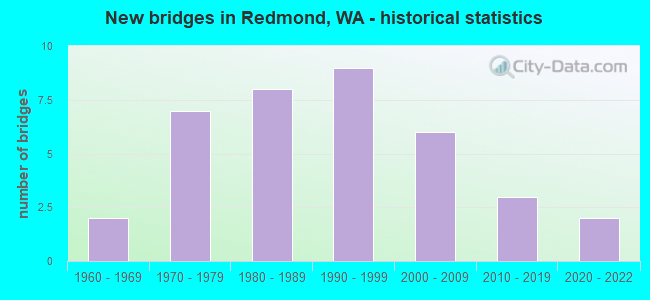
- New bridges - historical statistics
- 21960-1969
- 71970-1979
- 81980-1989
- 91990-1999
- 62000-2009
- 32010-2019
- 22020-2022
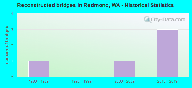
- Reconstructed bridges - Historical Statistics
- 11980-1989
- 01990-1999
- 12000-2009
- 32010-2019
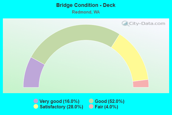
- Bridge Condition - Deck
- 16.0%Very good
- 52.0%Good
- 28.0%Satisfactory
- 4.0%Fair
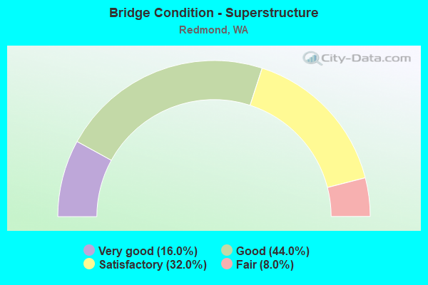
- Bridge Condition - Superstructure
- 16.0%Very good
- 44.0%Good
- 32.0%Satisfactory
- 8.0%Fair
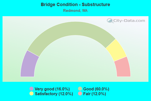
- Bridge Condition - Substructure
- 16.0%Very good
- 60.0%Good
- 12.0%Satisfactory
- 12.0%Fair
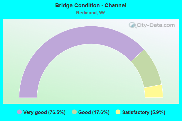
- Bridge Condition - Channel
- 76.5%Very good
- 17.6%Good
- 5.9%Satisfactory
Find on map >> Show street view
Structure Number: OW, Location: 2.5 MI E JCT I-405 (Lat: 47.673389, Lng: -122.132528), Route carried "on" structure: City street 908, Year Built: 1972, Status: Open, Structure Length: 6.00m (19.69ft), Average Daily Traffic: 27,000 (year 2019), Truck Traffic: 2%, Average Future Daily Traffic: 35,000 (year 2039), Design Load: HS 20, Features Intersected: SAMMAMISH R, Facility Carried by Structure: Redmond Way
Minimum Vertical Clearance: 30+ m (98+ ft), Kilometerpoint: 7.001, Lanes on structure: 4, Base Highway Network: Yes, Owner: City or Municipal Highway Agency, Approaching Roadway Width: 15.8m (51.8ft), Skew: 20 degrees, Material/Design: Concrete continuous, Design/Construction: Box Beam or Girders - Single/Spread, Number Of Spans In Main Unit: 3, Length of Maximum Span: 24.4m (80.1ft), Curb or Sidewalk Widths: Left: 1.8m (5.9ft), Right: 1.8m (5.9ft), Curb-To-Curb Width: 15.8m (51.8ft), Out-to-Out Width: 19.8m (65.0ft)
Condition: Deck: Good, Superstructure: Satisfactory, Substructure: Satisfactory, Channel: Good, Operating Rating: 46.3 metric tons, Method Used To Determine Operating Rating: Load Factor (LF) rating reported by rating factor (RF) method using MS18 loading, Inventory Rating: 27.9 metric tons, Method Used To Determine Inventory Rating: Load Factor (LF) rating reported by rating factor (RF) method using MS18 loading, Structural Evaluation: Equal to present minimum criteria, Deck Geometry: Meets minimum limits, Waterway Adequacy: Equal to present desirable criteria, Approach Roadway Alignment: Equal to present desirable criteria, Length Of Structure Improvement: 6.31m (20.70ft), Designated Inspection Frequency: Every 24 months, Inspection Date: May 2021, Bridge Improvement Cost: $5,134,000, Roadway Improvement Cost: $1,027,000, Total Project Cost: $10,267,000 ( Estimate for 2014), Deck Structure Type: Concrete Cast-file-Place, Wearing Surface/Protective System: Wearing Surface: Bituminous
Find on map >> Show street view
Structure Number: 10201A, Location: 4.9 E JCT I-405 (Lat: 47.667083, Lng: -122.127333), Route carried "on" structure: State highway 520, Year Built: 1976, Year Reconstructed: 2010, Status: Open, Structure Length: 11.80m (38.71ft), Average Daily Traffic: 49,682 (year 2019), Truck Traffic: 3%, Average Future Daily Traffic: 70,150 (year 2039), Design Load: HS 20+Mod, Features Intersected: WLS PKWY & SAMMAMISH R
Minimum Vertical Clearance: 30+ m (98+ ft), Kilometerpoint: 18.990, Lanes on structure: 3, Lanes under structure: 4, Base Highway Network: Yes, Owner: State Highway Agency, Approaching Roadway Width: 12.2m (40.0ft), Material/Design: Concrete continuous, Design/Construction: Box Beam or Girders - Multiple, Number Of Spans In Main Unit: 4, Length of Maximum Span: 38.7m (127.0ft), Curb-To-Curb Width: 17.1m (56.1ft), Out-to-Out Width: 18.0m (59.1ft)
Condition: Deck: Satisfactory, Superstructure: Good, Substructure: Good, Channel: Very good, Operating Rating: 68.0 metric tons, Method Used To Determine Operating Rating: Load Factor (LF), Inventory Rating: 40.8 metric tons, Method Used To Determine Inventory Rating: Load Factor (LF), Structural Evaluation: Better than present minimum criteria, Deck Geometry: Equal to present minimum criteria, Underclear: Superior to present desirable criteria, Waterway Adequacy: Equal to present desirable criteria, Approach Roadway Alignment: Equal to present minimum criteria, Length Of Structure Improvement: 11.80m (38.71ft), Designated Inspection Frequency: Every 48 months, Inspection Date: August 2018, Bridge Improvement Cost: $3,251,000, Roadway Improvement Cost: $650,000, Total Project Cost: $6,502,000 ( Estimate for 2014), Deck Structure Type: Concrete Cast-file-Place, Wearing Surface/Protective System: Wearing Surface: Monolithic Concrete
Find on map >> Show street view
Structure Number: 10849A, Location: 7.6 E JCT SR 522 (Lat: 47.670333, Lng: -122.109583), Route carried "on" structure: State highway 202, Year Built: 1978, Status: Open, Structure Length: 2.32m (7.61ft), Average Daily Traffic: 37,273 (year 2019), Truck Traffic: 5%, Average Future Daily Traffic: 52,629 (year 2039), Design Load: HS 20+Mod, Features Intersected: BEAR CREEK
Minimum Vertical Clearance: 30+ m (98+ ft), Kilometerpoint: 12.311, Lanes on structure: 5, Base Highway Network: Yes, Owner: State Highway Agency, Approaching Roadway Width: 19.2m (63.0ft), Material/Design: Prestressed concrete, Design/Construction: Tee Beam, Number Of Spans In Main Unit: 1, Length of Maximum Span: 21.6m (70.9ft), Curb or Sidewalk Widths: Left: 2.0m (6.6ft), Right: 2.0m (6.6ft), Curb-To-Curb Width: 19.2m (63.0ft), Out-to-Out Width: 24.1m (79.1ft)
Condition: Deck: Good, Superstructure: Good, Substructure: Good, Channel: Good, Operating Rating: 41.7 metric tons, Method Used To Determine Operating Rating: Load Factor (LF), Inventory Rating: 24.5 metric tons, Method Used To Determine Inventory Rating: Load Factor (LF), Structural Evaluation: Equal to present minimum criteria, Deck Geometry: Meets minimum limits, Waterway Adequacy: Equal to present desirable criteria, Approach Roadway Alignment: Equal to present desirable criteria, Length Of Structure Improvement: 2.32m (7.61ft), Designated Inspection Frequency: Every 48 months, Inspection Date: April 2018, Bridge Improvement Cost: $988,000, Roadway Improvement Cost: $198,000, Total Project Cost: $1,976,000 ( Estimate for 2014), Deck Structure Type: Other, Wearing Surface/Protective System: Wearing Surface: Bituminous, Membrane: Preformed Fabric
Find on map >> Show street view
Structure Number: 11314A, Location: 3.3 E JCT I-405 (Lat: 47.646028, Lng: -122.134417), Route carried "on" structure: City street , Year Built: 1980, Year Reconstructed: 2000, Status: Open, Structure Length: 6.68m (21.92ft), Average Daily Traffic: 26,907 (year 2007), Truck Traffic: 5%, Design Load: HS 20+Mod, Features Intersected: SR 520, Facility Carried by Structure: NE 40TH ST
Minimum Vertical Clearance: 30+ m (98+ ft), Kilometerpoint: 0.016, Lanes on structure: 8, Lanes under structure: 7, Owner: State Highway Agency, Approaching Roadway Width: 28.7m (94.2ft), Skew: 1 degrees, Material/Design: Prestressed concrete continuous, Design/Construction: Stringer/Multi-beam, Number Of Spans In Main Unit: 2, Length of Maximum Span: 35.4m (116.1ft), Curb or Sidewalk Widths: Left: 4.6m (15.1ft), Right: 1.7m (5.6ft), Curb-To-Curb Width: 28.7m (94.2ft), Out-to-Out Width: 35.9m (117.8ft)
Condition: Deck: Good, Superstructure: Satisfactory, Substructure: Fair, Operating Rating: 73.5 metric tons, Method Used To Determine Operating Rating: Load Factor (LF), Inventory Rating: 43.5 metric tons, Method Used To Determine Inventory Rating: Load Factor (LF), Structural Evaluation: Somewhat better than minimum adequacy, Deck Geometry: High priority of corrective action, Underclear: Equal to present minimum criteria, Approach Roadway Alignment: Equal to present desirable criteria, Length Of Structure Improvement: 6.68m (21.92ft), Designated Inspection Frequency: Every 24 months, Inspection Date: September 2021, Bridge Improvement Cost: $4,205,000, Roadway Improvement Cost: $841,000, Total Project Cost: $8,410,000 ( Estimate for 2014), Deck Structure Type: Concrete Cast-file-Place, Wearing Surface/Protective System: Wearing Surface: Monolithic Concrete, Deck Protection: Epoxy Coated Reinforcing
Find on map >> Show street view
Structure Number: 11314B, Location: 4.4 E JCT I-405 (Lat: 47.660639, Lng: -122.134806), Route carried "on" structure: City street , Year Built: 1980, Status: Open, Structure Length: 7.74m (25.39ft), Average Daily Traffic: 3,200 (year 2008), Truck Traffic: 5%, Average Future Daily Traffic: 5,171 (year 2036), Design Load: HS 20+Mod, Features Intersected: SR 520, Facility Carried by Structure: NE 60TH AVE
Minimum Vertical Clearance: 30+ m (98+ ft), Kilometerpoint: 0.869, Lanes on structure: 2, Lanes under structure: 8, Owner: State Highway Agency, Approaching Roadway Width: 13.4m (44.0ft), Skew: 2 degrees, Material/Design: Prestressed concrete continuous, Design/Construction: Stringer/Multi-beam, Number Of Spans In Main Unit: 2, Length of Maximum Span: 40.8m (133.9ft), Curb or Sidewalk Widths: Left: 1.5m (4.9ft), Right: 1.5m (4.9ft), Curb-To-Curb Width: 13.4m (44.0ft), Out-to-Out Width: 17.2m (56.4ft)
Condition: Deck: Good, Superstructure: Good, Substructure: Good, Operating Rating: 89.8 metric tons, Method Used To Determine Operating Rating: Load Factor (LF), Inventory Rating: 52.6 metric tons, Method Used To Determine Inventory Rating: Load Factor (LF), Structural Evaluation: Better than present minimum criteria, Deck Geometry: Better than present minimum criteria, Underclear: High priority of corrective action, Approach Roadway Alignment: Equal to present desirable criteria, Length Of Structure Improvement: 7.74m (25.39ft), Designated Inspection Frequency: Every 48 months, Inspection Date: April 2018, Bridge Improvement Cost: $2,337,000, Roadway Improvement Cost: $467,000, Total Project Cost: $4,674,000 ( Estimate for 2014), Deck Structure Type: Concrete Cast-file-Place, Wearing Surface/Protective System: Wearing Surface: Monolithic Concrete
Find on map >> Show street view
Structure Number: 12854A, Location: 3.9 E JCT I-405 (Lat: 47.654361, Lng: -122.137278), Route carried "on" structure: City street , Year Built: 1987, Status: Open, Structure Length: 6.95m (22.80ft), Average Daily Traffic: 14,591 (year 2010), Truck Traffic: 5%, Average Future Daily Traffic: 22,937 (year 2036), Design Load: HS 20+Mod, Features Intersected: SR 520, Facility Carried by Structure: NE 51ST STREET
Minimum Vertical Clearance: 30+ m (98+ ft), Kilometerpoint: 0.064, Lanes on structure: 5, Lanes under structure: 7, Owner: State Highway Agency, Approaching Roadway Width: 19.2m (63.0ft), Material/Design: Prestressed concrete continuous, Design/Construction: Stringer/Multi-beam, Number Of Spans In Main Unit: 2, Length of Maximum Span: 35.1m (115.2ft), Curb or Sidewalk Widths: Left: 1.8m (5.9ft), Right: 1.8m (5.9ft), Curb-To-Curb Width: 19.2m (63.0ft), Out-to-Out Width: 23.5m (77.1ft)
Condition: Deck: Good, Superstructure: Good, Substructure: Good, Operating Rating: 89.8 metric tons, Method Used To Determine Operating Rating: Load Factor (LF), Inventory Rating: 53.5 metric tons, Method Used To Determine Inventory Rating: Load Factor (LF), Structural Evaluation: Better than present minimum criteria, Deck Geometry: Meets minimum limits, Underclear: Somewhat better than minimum adequacy, Approach Roadway Alignment: Equal to present desirable criteria, Length Of Structure Improvement: 6.95m (22.80ft), Designated Inspection Frequency: Every 48 months, Inspection Date: April 2018, Bridge Improvement Cost: $2,964,000, Roadway Improvement Cost: $593,000, Total Project Cost: $5,928,000 ( Estimate for 2014), Deck Structure Type: Concrete Cast-file-Place, Wearing Surface/Protective System: Wearing Surface: Monolithic Concrete, Deck Protection: Epoxy Coated Reinforcing
Find on map >> Show street view
Structure Number: 14444A, Location: 4.9 E JCT I-405 (Lat: 47.667306, Lng: -122.127361), Route carried "on" structure: State highway 520, Year Built: 1995, Status: Open, Structure Length: 12.31m (40.39ft), Average Daily Traffic: 49,682 (year 2019), Truck Traffic: 3%, Average Future Daily Traffic: 70,150 (year 2039), Design Load: HS 25 or greater, Features Intersected: PKWY & SAMMAMISH RIVER
Minimum Vertical Clearance: 30+ m (98+ ft), Kilometerpoint: 18.990, Lanes on structure: 3, Lanes under structure: 3, Base Highway Network: Yes, Owner: State Highway Agency, Approaching Roadway Width: 16.8m (55.1ft), Material/Design: Prestressed concrete continuous, Design/Construction: Box Beam or Girders - Multiple, Number Of Spans In Main Unit: 4, Length of Maximum Span: 38.7m (127.0ft), Curb-To-Curb Width: 16.8m (55.1ft), Out-to-Out Width: 17.7m (58.1ft)
Condition: Deck: Good, Superstructure: Good, Substructure: Good, Channel: Very good, Operating Rating: 89.8 metric tons, Method Used To Determine Operating Rating: Load Factor (LF), Inventory Rating: 84.4 metric tons, Method Used To Determine Inventory Rating: Load Factor (LF), Structural Evaluation: Better than present minimum criteria, Deck Geometry: Equal to present minimum criteria, Underclear: Superior to present desirable criteria, Waterway Adequacy: Equal to present desirable criteria, Approach Roadway Alignment: Equal to present minimum criteria, Length Of Structure Improvement: 12.31m (40.39ft), Designated Inspection Frequency: Every 48 months, Inspection Date: August 2018, Bridge Improvement Cost: $4,606,000, Roadway Improvement Cost: $921,000, Total Project Cost: $9,211,000 ( Estimate for 2014), Deck Structure Type: Concrete Cast-file-Place, Wearing Surface/Protective System: Wearing Surface: Monolithic Concrete, Deck Protection: Epoxy Coated Reinforcing
Find on map >> Show street view
Structure Number: 14444B, Location: 5.8 E JCT I-405 (Lat: 47.668861, Lng: -122.107944), Route carried "on" structure: State highway 520, Year Built: 1995, Year Reconstructed: 2010, Status: Open, Structure Length: 14.11m (46.29ft), Average Daily Traffic: 40,852 (year 2019), Truck Traffic: 3%, Average Future Daily Traffic: 57,683 (year 2039), Design Load: HS 25 or greater, Features Intersected: SR 202 & BIKE PATH
Minimum Vertical Clearance: 30+ m (98+ ft), Kilometerpoint: 20.503, Lanes on structure: 3, Lanes under structure: 6, Base Highway Network: Yes, Owner: State Highway Agency, Approaching Roadway Width: 30.5m (100.1ft), Skew: 30 degrees, Material/Design: Prestressed concrete continuous, Design/Construction: Stringer/Multi-beam, Number Of Spans In Main Unit: 5, Length of Maximum Span: 29.9m (98.1ft), Curb-To-Curb Width: 30.5m (100.1ft), Out-to-Out Width: 31.9m (104.7ft)
Condition: Deck: Good, Superstructure: Satisfactory, Substructure: Good, Operating Rating: 72.6 metric tons, Method Used To Determine Operating Rating: Load Factor (LF), Inventory Rating: 42.6 metric tons, Method Used To Determine Inventory Rating: Load Factor (LF), Structural Evaluation: Equal to present minimum criteria, Deck Geometry: Superior to present desirable criteria, Underclear: High priority of corrective action, Approach Roadway Alignment: Equal to present desirable criteria, Length Of Structure Improvement: 14.11m (46.29ft), Designated Inspection Frequency: Every 24 months, Inspection Date: Febuary 2020, Bridge Improvement Cost: $9,445,000, Roadway Improvement Cost: $1,889,000, Total Project Cost: $18,890,000 ( Estimate for 2014), Deck Structure Type: Concrete Cast-file-Place, Wearing Surface/Protective System: Wearing Surface: Monolithic Concrete, Deck Protection: Epoxy Coated Reinforcing
Find on map >> Show street view
Structure Number: 14444C, Location: 0.1 E JCT SR 202 (Lat: 47.670719, Lng: -122.106856), Route carried "on" structure: City street 520, Year Built: 1996, Year Reconstructed: 2010, Status: Open, Structure Length: 6.89m (22.60ft), Average Daily Traffic: 33,156 (year 2012), Truck Traffic: 4%, Average Future Daily Traffic: 53,050 (year 2036), Design Load: HS 25 or greater, Features Intersected: RAMP & NE 76TH, Facility Carried by Structure: ACCESS (AVONDALE)
Minimum Vertical Clearance: 30+ m (98+ ft), Kilometerpoint: 0.064, Lanes on structure: 5, Lanes under structure: 5, Base Highway Network: Yes, Owner: State Highway Agency, Approaching Roadway Width: 26.5m (86.9ft), Skew: 32 degrees, Material/Design: Prestressed concrete continuous, Design/Construction: Stringer/Multi-beam, Number Of Spans In Main Unit: 2, Length of Maximum Span: 35.4m (116.1ft), Curb-To-Curb Width: 27.1m (88.9ft), Out-to-Out Width: 29.4m (96.5ft)
Condition: Deck: Good, Superstructure: Good, Substructure: Good, Operating Rating: 65.3 metric tons, Method Used To Determine Operating Rating: Load Factor (LF), Inventory Rating: 39.0 metric tons, Method Used To Determine Inventory Rating: Load Factor (LF), Structural Evaluation: Better than present minimum criteria, Deck Geometry: Superior to present desirable criteria, Underclear: Equal to present minimum criteria, Approach Roadway Alignment: Equal to present desirable criteria, Length Of Structure Improvement: 6.89m (22.60ft), Designated Inspection Frequency: Every 48 months, Inspection Date: August 2018, Bridge Improvement Cost: $4,023,000, Roadway Improvement Cost: $805,000, Total Project Cost: $8,046,000 ( Estimate for 2014), Deck Structure Type: Concrete Cast-file-Place, Wearing Surface/Protective System: Wearing Surface: Monolithic Concrete, Deck Protection: Epoxy Coated Reinforcing
Find on map >> Show street view
Structure Number: 17272A, Location: JCT SR 520 (Lat: 47.670111, Lng: -122.107861), Route carried "on" structure: Ramp State highway 202, Year Built: 2007, Status: Open, Structure Length: 13.26m (43.50ft), Average Daily Traffic: 16,261 (year 2012), Truck Traffic: 3%, Average Future Daily Traffic: 26,018 (year 2036), Design Load: HL 93, Features Intersected: SR 202 BNRR, Facility Carried by Structure: W-W RAMP
Minimum Vertical Clearance: 30+ m (98+ ft), Kilometerpoint: 0.499, Lanes on structure: 3, Lanes under structure: 5, Owner: State Highway Agency, Approaching Roadway Width: 14.0m (45.9ft), Material/Design: Prestressed concrete continuous, Design/Construction: Stringer/Multi-beam, Number Of Spans In Main Unit: 3, Length of Maximum Span: 44.2m (145.0ft), Curb-To-Curb Width: 13.7m (44.9ft), Out-to-Out Width: 14.6m (47.9ft)
Condition: Deck: Very good, Superstructure: Very good, Substructure: Very good, Operating Rating: 89.8 metric tons, Method Used To Determine Operating Rating: Load Factor (LF), Inventory Rating: 57.1 metric tons, Method Used To Determine Inventory Rating: Load Factor (LF), Structural Evaluation: Equal to present desirable criteria, Deck Geometry: Equal to present minimum criteria, Underclear: Equal to present minimum criteria, Approach Roadway Alignment: Equal to present minimum criteria, Length Of Structure Improvement: 13.26m (43.50ft), Designated Inspection Frequency: Every 24 months, Inspection Date: March 2020, Bridge Improvement Cost: $4,176,000, Roadway Improvement Cost: $835,000, Total Project Cost: $8,352,000 ( Estimate for 2014), Deck Structure Type: Concrete Cast-file-Place, Wearing Surface/Protective System: Wearing Surface: Monolithic Concrete, Deck Protection: Epoxy Coated Reinforcing
Find on map >> Show street view
Structure Number: 17637A, Location: 4.9 E JCT I-405 (Lat: 47.667361, Lng: -122.127444), Route carried "on" structure: Ramp State highway 520, Year Built: 2010, Status: Open, Structure Length: 12.19m (39.99ft), Average Daily Traffic: 3,902 (year 2012), Truck Traffic: 3%, Design Load: HL 93, Features Intersected: SAMMAMISH PKWY/RIVER
Minimum Vertical Clearance: 30+ m (98+ ft), Kilometerpoint: 0.290, Lanes on structure: 1, Lanes under structure: 4, Owner: State Highway Agency, Approaching Roadway Width: 8.2m (26.9ft), Material/Design: Prestressed concrete continuous, Design/Construction: Stringer/Multi-beam, Number Of Spans In Main Unit: 4, Length of Maximum Span: 40.2m (131.9ft), Curb-To-Curb Width: 8.2m (26.9ft), Out-to-Out Width: 8.8m (28.9ft)
Condition: Deck: Very good, Superstructure: Very good, Substructure: Very good, Channel: Very good, Operating Rating: 89.8 metric tons, Method Used To Determine Operating Rating: Load Factor (LF), Inventory Rating: 59.9 metric tons, Method Used To Determine Inventory Rating: Load Factor (LF), Structural Evaluation: Equal to present desirable criteria, Deck Geometry: Superior to present desirable criteria, Underclear: Superior to present desirable criteria, Waterway Adequacy: Equal to present desirable criteria, Approach Roadway Alignment: Equal to present desirable criteria, Length Of Structure Improvement: 12.19m (39.99ft), Designated Inspection Frequency: Every 48 months, Inspection Date: August 2018, Bridge Improvement Cost: $2,320,000, Roadway Improvement Cost: $464,000, Total Project Cost: $4,640,000 ( Estimate for 2014), Deck Structure Type: Concrete Cast-file-Place, Wearing Surface/Protective System: Wearing Surface: Monolithic Concrete, Deck Protection: Epoxy Coated Reinforcing
Find on map >> Show street view
Structure Number: 17637B, Location: 4.9 E JCT I-405 (Lat: 47.666839, Lng: -122.127392), Route carried "on" structure: Ramp State highway 520, Year Built: 2010, Status: Open, Structure Length: 11.46m (37.60ft), Average Daily Traffic: 4,606 (year 2012), Truck Traffic: 3%, Design Load: HL 93, Features Intersected: W L SAMMAMISH PKWY/RIVER
Minimum Vertical Clearance: 30+ m (98+ ft), Kilometerpoint: 0.257, Lanes on structure: 1, Lanes under structure: 4, Owner: State Highway Agency, Approaching Roadway Width: 8.2m (26.9ft), Material/Design: Prestressed concrete continuous, Design/Construction: Stringer/Multi-beam, Number Of Spans In Main Unit: 4, Length of Maximum Span: 38.7m (127.0ft), Curb-To-Curb Width: 8.2m (26.9ft), Out-to-Out Width: 8.8m (28.9ft)
Condition: Deck: Very good, Superstructure: Very good, Substructure: Very good, Channel: Very good, Operating Rating: 89.8 metric tons, Method Used To Determine Operating Rating: Load Factor (LF), Inventory Rating: 55.3 metric tons, Method Used To Determine Inventory Rating: Load Factor (LF), Structural Evaluation: Equal to present desirable criteria, Deck Geometry: Superior to present desirable criteria, Underclear: Superior to present desirable criteria, Waterway Adequacy: Equal to present desirable criteria, Approach Roadway Alignment: Equal to present desirable criteria, Length Of Structure Improvement: 11.46m (37.60ft), Designated Inspection Frequency: Every 48 months, Inspection Date: August 2018, Bridge Improvement Cost: $2,181,000, Roadway Improvement Cost: $436,000, Total Project Cost: $4,362,000 ( Estimate for 2014), Deck Structure Type: Concrete Cast-file-Place, Wearing Surface/Protective System: Wearing Surface: Monolithic Concrete, Deck Protection: Epoxy Coated Reinforcing
Find on map >> Show street view
Structure Number: 200365, Location: 2.5 MI E JCT I-405 (Lat: 47.673556, Lng: -122.133500), Route carried "on" structure: City street 908, Year Built: 1992, Status: Open, Structure Length: 2.62m (8.60ft), Average Daily Traffic: 27,000 (year 2019), Truck Traffic: 2%, Average Future Daily Traffic: 35,000 (year 2039), Design Load: HS 20, Features Intersected: 154TH AVE NE, Facility Carried by Structure: REDMOND WAY
Minimum Vertical Clearance: 30+ m (98+ ft), Kilometerpoint: 7.033, Lanes on structure: 6, Lanes under structure: 4, Base Highway Network: Yes, Owner: City or Municipal Highway Agency, Approaching Roadway Width: 15.8m (51.8ft), Skew: 1 degrees, Material/Design: Prestressed concrete, Design/Construction: Stringer/Multi-beam, Number Of Spans In Main Unit: 1, Length of Maximum Span: 25.3m (83.0ft), Curb or Sidewalk Widths: Left: 1.8m (5.9ft), Right: 1.8m (5.9ft), Curb-To-Curb Width: 19.4m (63.6ft), Out-to-Out Width: 24.9m (81.7ft)
Condition: Deck: Good, Superstructure: Good, Substructure: Good, Operating Rating: 40.2 metric tons, Method Used To Determine Operating Rating: Load and Resistance Factor Rating (LRFR) rating reported by rating factor(RF) method using HL-93 loadings, Inventory Rating: 20.4 metric tons, Method Used To Determine Inventory Rating: Load and Resistance Factor Rating (LRFR) rating reported by rating factor(RF) method using HL-93 loadings, Structural Evaluation: Somewhat better than minimum adequacy, Deck Geometry: High priority of replacement, Underclear: High priority of replacement, Approach Roadway Alignment: Equal to present desirable criteria, Length Of Structure Improvement: 2.93m (9.61ft), Designated Inspection Frequency: Every 24 months, Inspection Date: May 2021, Bridge Improvement Cost: $3,302,000, Roadway Improvement Cost: $660,000, Total Project Cost: $6,605,000 ( Estimate for 2014), Deck Structure Type: Other, Wearing Surface/Protective System: Wearing Surface: Bituminous, Deck Protection: Epoxy Coated Reinforcing
Find on map >> Show street view
Structure Number: 80413, Location: 1.0 MI NE OF SR-520 (Lat: 47.688722, Lng: -122.090083), Route carried "on" structure: City street 96800, Year Built: 1974, Status: Open, Structure Length: 0.98m (3.22ft), Average Daily Traffic: 23,000 (year 2019), Truck Traffic: 15%, Average Future Daily Traffic: 30,000 (year 2039), Design Load: HS 20, Features Intersected: BEAR CREEK, Facility Carried by Structure: NOVELTY HILL RD
Minimum Vertical Clearance: 30+ m (98+ ft), Kilometerpoint: 0.001, Lanes on structure: 2, Owner: City or Municipal Highway Agency, Approaching Roadway Width: 10.7m (35.1ft), Skew: 2 degrees, Material/Design: Steel, Design/Construction: Culvert, Number Of Spans In Main Unit: 1, Length of Maximum Span: 9.8m (32.2ft), Curb-To-Curb Width: 10.7m (35.1ft), Out-to-Out Width: 11.6m (38.1ft)
Condition: Channel: Satisfactory, Culverts: Satisfactory, Operating Rating: 89.8 metric tons, Method Used To Determine Operating Rating: Load and Resistance Factor (LRFR), Inventory Rating: 87.1 metric tons, Method Used To Determine Inventory Rating: Load and Resistance Factor (LRFR), Structural Evaluation: Equal to present minimum criteria, Deck Geometry: Meets minimum limits, Waterway Adequacy: Equal to present desirable criteria, Approach Roadway Alignment: Equal to present desirable criteria, Length Of Structure Improvement: 0.98m (3.22ft), Designated Inspection Frequency: Every 24 months, Inspection Date: May 2021, Bridge Improvement Cost: $237,000, Roadway Improvement Cost: $47,000, Total Project Cost: $474,000 ( Estimate for 2014)
Find on map >> Show street view
Structure Number: 80543, Location: 0.5 MI S OF SR-520 (Lat: 47.662211, Lng: -122.124617), Route carried "on" structure: Spur County highway , Year Built: 1963, Status: Open, Structure Length: 3.57m (11.71ft), Average Daily Traffic: 1,600 (year 2018), Truck Traffic: 5%, Average Future Daily Traffic: 1,850 (year 2038), Design Load: HS 20, Features Intersected: SAMMAMISH SLOUGH, Facility Carried by Structure: NE MARYMOOR WAY
Minimum Vertical Clearance: 30+ m (98+ ft), Kilometerpoint: 0.001, Lanes on structure: 2, Owner: Local Park, Forest, or Reservation Agency, Approaching Roadway Width: 11.6m (38.1ft), Material/Design: Concrete, Design/Construction: Tee Beam, Number Of Spans In Main Unit: 3, Length of Maximum Span: 16.2m (53.1ft), Curb or Sidewalk Widths: Left: 1.2m (3.9ft), Right: 1.2m (3.9ft), Curb-To-Curb Width: 7.9m (25.9ft), Out-to-Out Width: 11.0m (36.1ft)
Condition: Deck: Satisfactory, Superstructure: Good, Substructure: Satisfactory, Channel: Very good, Operating Rating: 30.8 metric tons, Method Used To Determine Operating Rating: Load Factor (LF), Inventory Rating: 18.1 metric tons, Method Used To Determine Inventory Rating: Load Factor (LF), Structural Evaluation: Somewhat better than minimum adequacy, Deck Geometry: Meets minimum limits, Waterway Adequacy: Equal to present desirable criteria, Approach Roadway Alignment: Equal to present desirable criteria, Length Of Structure Improvement: 3.87m (12.70ft), Designated Inspection Frequency: Every 24 months, Inspection Date: June 2020, Bridge Improvement Cost: $1,930,000, Roadway Improvement Cost: $386,000, Total Project Cost: $3,861,000 ( Estimate for 2014), Deck Structure Type: Other, Wearing Surface/Protective System: Wearing Surface: Monolithic Concrete
Find on map >> Show street view
Structure Number: 85691, Location: 0.5 MI W OF JCT SR-202 (Lat: 47.678628, Lng: -122.132700), Route carried "on" structure: City street 1065, Year Built: 1985, Status: Open, Structure Length: 5.46m (17.91ft), Average Daily Traffic: 12,000 (year 2017), Truck Traffic: 3%, Average Future Daily Traffic: 16,500 (year 2038), Design Load: HS 20, Features Intersected: SAMMAMISH RIVER, Facility Carried by Structure: NE 85TH STREET
Minimum Vertical Clearance: 30+ m (98+ ft), Kilometerpoint: 0.001, Lanes on structure: 3, Owner: City or Municipal Highway Agency, Approaching Roadway Width: 17.1m (56.1ft), Material/Design: Concrete continuous, Design/Construction: Box Beam or Girders - Single/Spread, Number Of Spans In Main Unit: 3, Length of Maximum Span: 27.4m (89.9ft), Curb or Sidewalk Widths: Left: 1.5m (4.9ft), Right: 1.5m (4.9ft), Curb-To-Curb Width: 17.1m (56.1ft), Out-to-Out Width: 20.7m (67.9ft)
Condition: Deck: Fair, Superstructure: Fair, Substructure: Good, Channel: Very good, Operating Rating: 60.8 metric tons, Method Used To Determine Operating Rating: Load Factor (LF), Inventory Rating: 36.3 metric tons, Method Used To Determine Inventory Rating: Load Factor (LF), Structural Evaluation: Somewhat better than minimum adequacy, Deck Geometry: Superior to present desirable criteria, Waterway Adequacy: Equal to present desirable criteria, Approach Roadway Alignment: Equal to present desirable criteria, Length Of Structure Improvement: 5.76m (18.90ft), Designated Inspection Frequency: Every 24 months, Inspection Date: April 2021, Bridge Improvement Cost: $3,780,000, Roadway Improvement Cost: $756,000, Total Project Cost: $7,560,000 ( Estimate for 2014), Deck Structure Type: Concrete Cast-file-Place, Wearing Surface/Protective System: Wearing Surface: Monolithic Concrete, Deck Protection: Epoxy Coated Reinforcing
Find on map >> Show street view
Structure Number: 85692, Location: 1.0 MI E OF I-405 (Lat: 47.667139, Lng: -122.157000), Route carried "on" structure: City street 1065, Year Built: 1970, Status: Open, Structure Length: 1.10m (3.61ft), Average Daily Traffic: 13,100 (year 2018), Truck Traffic: 4%, Average Future Daily Traffic: 16,055 (year 2038), Design Load: HS 20, Features Intersected: 138th AVE NE, Facility Carried by Structure: OLD REDMOND ROAD
Minimum Vertical Clearance: 30+ m (98+ ft), Kilometerpoint: 0.001, Lanes on structure: 2, Lanes under structure: 2, Owner: City or Municipal Highway Agency, Approaching Roadway Width: 13.4m (44.0ft), Material/Design: Concrete, Design/Construction: Channel Beam, Number Of Spans In Main Unit: 1, Length of Maximum Span: 10.4m (34.1ft), Curb or Sidewalk Widths: Left: 1.7m (5.6ft), Right: 1.7m (5.6ft), Curb-To-Curb Width: 13.4m (44.0ft), Out-to-Out Width: 17.2m (56.4ft)
Condition: Deck: Satisfactory, Superstructure: Fair, Substructure: Fair, Operating Rating: 39.9 metric tons, Method Used To Determine Operating Rating: Load Factor (LF) rating reported by rating factor (RF) method using MS18 loading, Inventory Rating: 24.0 metric tons, Method Used To Determine Inventory Rating: Load Factor (LF) rating reported by rating factor (RF) method using MS18 loading, Structural Evaluation: Somewhat better than minimum adequacy, Deck Geometry: Equal to present minimum criteria, Underclear: High priority of replacement, Approach Roadway Alignment: Equal to present minimum criteria, Length Of Structure Improvement: 1.40m (4.59ft), Designated Inspection Frequency: Every 24 months, Inspection Date: May 2021, Bridge Improvement Cost: $699,000, Roadway Improvement Cost: $140,000, Total Project Cost: $1,398,000 ( Estimate for 2014), Deck Structure Type: Other, Wearing Surface/Protective System: Wearing Surface: Bituminous
Find on map >> Show street view
Structure Number: 85694, Location: .4 N JCT 520/202 (Lat: 47.675833, Lng: -122.106000), Route carried "on" structure: City street 1065, Year Built: 1979, Year Reconstructed: 1988, Status: Open, Structure Length: 1.58m (5.18ft), Average Daily Traffic: 34,500 (year 2017), Truck Traffic: 7%, Average Future Daily Traffic: 46,500 (year 2039), Design Load: HS 20, Features Intersected: BEAR CREEK, Facility Carried by Structure: AVONDALE ROAD
Minimum Vertical Clearance: 30+ m (98+ ft), Kilometerpoint: 0.724, Lanes on structure: 5, Base Highway Network: Yes, Owner: City or Municipal Highway Agency, Approaching Roadway Width: 19.2m (63.0ft), Skew: 20 degrees, Material/Design: Concrete, Design/Construction: Channel Beam, Number Of Spans In Main Unit: 1, Length of Maximum Span: 15.2m (49.9ft), Curb or Sidewalk Widths: Left: 0.0m, Right: 2.0m (6.6ft), Curb-To-Curb Width: 19.2m (63.0ft), Out-to-Out Width: 21.9m (71.9ft)
Condition: Deck: Satisfactory, Superstructure: Satisfactory, Substructure: Fair, Channel: Very good, Operating Rating: 45.0 metric tons, Method Used To Determine Operating Rating: Load and Resistance Factor Rating (LRFR) rating reported by rating factor(RF) method using HL-93 loadings, Inventory Rating: 24.0 metric tons, Method Used To Determine Inventory Rating: Load and Resistance Factor Rating (LRFR) rating reported by rating factor(RF) method using HL-93 loadings, Structural Evaluation: Somewhat better than minimum adequacy, Deck Geometry: Meets minimum limits, Waterway Adequacy: Equal to present desirable criteria, Approach Roadway Alignment: Equal to present desirable criteria, Length Of Structure Improvement: 1.89m (6.20ft), Designated Inspection Frequency: Every 24 months, Inspection Date: May 2021, Bridge Improvement Cost: $1,835,000, Roadway Improvement Cost: $367,000, Total Project Cost: $3,670,000 ( Estimate for 2014), Deck Structure Type: Other, Wearing Surface/Protective System: Wearing Surface: Bituminous, Deck Protection: Epoxy Coated Reinforcing
Find on map >> Show street view
Structure Number: 85762, Location: 0.1 MI N OF JCT SR-908 (Lat: 47.676333, Lng: -122.143694), Route carried "on" structure: City street 1065, Year Built: 1991, Status: Open, Structure Length: 15.39m (50.49ft), Average Daily Traffic: 18,000 (year 2019), Truck Traffic: 5%, Average Future Daily Traffic: 21,000 (year 2039), Design Load: HS 20, Features Intersected: HILLSIDE SLOPE, Facility Carried by Structure: 148TH AVE NE
Minimum Vertical Clearance: 30+ m (98+ ft), Kilometerpoint: 0.001, Lanes on structure: 4, Base Highway Network: Yes, Owner: City or Municipal Highway Agency, Approaching Roadway Width: 15.5m (50.9ft), Skew: 20 degrees, Material/Design: Prestressed concrete continuous, Design/Construction: Stringer/Multi-beam, Number Of Spans In Main Unit: 6, Length of Maximum Span: 27.4m (89.9ft), Curb or Sidewalk Widths: Left: 2.7m (8.9ft), Right: 0.0m, Curb-To-Curb Width: 15.5m (50.9ft), Out-to-Out Width: 19.1m (62.7ft)
Condition: Deck: Satisfactory, Superstructure: Satisfactory, Substructure: Good, Operating Rating: 33.4 metric tons, Method Used To Determine Operating Rating: Load and Resistance Factor Rating (LRFR) rating reported by rating factor(RF) method using HL-93 loadings, Inventory Rating: 19.1 metric tons, Method Used To Determine Inventory Rating: Load and Resistance Factor Rating (LRFR) rating reported by rating factor(RF) method using HL-93 loadings, Structural Evaluation: Meets minimum limits, Deck Geometry: Meets minimum limits, Approach Roadway Alignment: Equal to present desirable criteria, Length Of Structure Improvement: 15.39m (50.49ft), Designated Inspection Frequency: Every 24 months, Inspection Date: May 2021, Bridge Improvement Cost: $5,353,000, Roadway Improvement Cost: $1,071,000, Total Project Cost: $10,706,000 ( Estimate for 2014), Deck Structure Type: Concrete Cast-file-Place, Wearing Surface/Protective System: Wearing Surface: Monolithic Concrete, Deck Protection: Epoxy Coated Reinforcing
Find on map >> Show street view
Structure Number: 85985, Location: 0.4 MILES S JCT SR 908 (Lat: 47.670353, Lng: -122.127981), Route carried "on" structure: City street 1065, Year Built: 1992, Status: Open, Structure Length: 3.51m (11.52ft), Average Daily Traffic: 30,000 (year 2019), Truck Traffic: 4%, Average Future Daily Traffic: 40,000 (year 2038), Design Load: HS 20, Features Intersected: SAMMAMISH RIVER, Facility Carried by Structure: LEARY WAY
Minimum Vertical Clearance: 30+ m (98+ ft), Kilometerpoint: 0.001, Lanes on structure: 4, Owner: City or Municipal Highway Agency, Approaching Roadway Width: 14.6m (47.9ft), Material/Design: Concrete continuous, Design/Construction: Box Beam or Girders - Single/Spread, Number Of Spans In Main Unit: 3, Length of Maximum Span: 10.1m (33.1ft), Curb or Sidewalk Widths: Left: 1.7m (5.6ft), Right: 2.6m (8.5ft), Curb-To-Curb Width: 14.6m (47.9ft), Out-to-Out Width: 19.4m (63.6ft)
Condition: Deck: Good, Superstructure: Satisfactory, Substructure: Good, Channel: Good, Operating Rating: 54.4 metric tons, Method Used To Determine Operating Rating: Load Factor (LF), Inventory Rating: 32.7 metric tons, Method Used To Determine Inventory Rating: Load Factor (LF), Structural Evaluation: Equal to present minimum criteria, Deck Geometry: High priority of replacement, Waterway Adequacy: Equal to present desirable criteria, Approach Roadway Alignment: Equal to present desirable criteria, Length Of Structure Improvement: 3.81m (12.50ft), Designated Inspection Frequency: Every 24 months, Inspection Date: April 2021, Bridge Improvement Cost: $3,100,000, Roadway Improvement Cost: $620,000, Total Project Cost: $6,200,000 ( Estimate for 2014), Deck Structure Type: Concrete Cast-file-Place, Wearing Surface/Protective System: Wearing Surface: Monolithic Concrete, Deck Protection: Epoxy Coated Reinforcing
Find on map >> Show street view
Structure Number: 86194, Location: 0.1 W AVONDALE RD (Lat: 47.674694, Lng: -122.107517), Route carried "on" structure: City street 1065, Year Built: 1994, Status: Open, Structure Length: 3.44m (11.29ft), Average Daily Traffic: 23,866 (year 2019), Truck Traffic: 5%, Average Future Daily Traffic: 30,000 (year 2039), Design Load: HS 25 or greater, Features Intersected: BEAR CREEK, Facility Carried by Structure: UNION HILL ROAD
Minimum Vertical Clearance: 30+ m (98+ ft), Kilometerpoint: 0.001, Lanes on structure: 3, Owner: City or Municipal Highway Agency, Approaching Roadway Width: 18.9m (62.0ft), Skew: 24 degrees, Material/Design: Concrete continuous, Design/Construction: Slab, Number Of Spans In Main Unit: 3, Length of Maximum Span: 13.4m (44.0ft), Curb or Sidewalk Widths: Left: 2.3m (7.5ft), Right: 2.3m (7.5ft), Curb-To-Curb Width: 26.8m (87.9ft), Out-to-Out Width: 32.0m (105.0ft)
Condition: Deck: Satisfactory, Superstructure: Satisfactory, Substructure: Good, Channel: Very good, Operating Rating: 71.7 metric tons, Method Used To Determine Operating Rating: Load Factor (LF), Inventory Rating: 42.6 metric tons, Method Used To Determine Inventory Rating: Load Factor (LF), Structural Evaluation: Equal to present minimum criteria, Deck Geometry: Superior to present desirable criteria, Waterway Adequacy: Equal to present desirable criteria, Approach Roadway Alignment: Equal to present desirable criteria, Length Of Structure Improvement: 3.44m (11.29ft), Designated Inspection Frequency: Every 24 months, Inspection Date: May 2021, Bridge Improvement Cost: $1,446,000, Roadway Improvement Cost: $289,000, Total Project Cost: $2,893,000 ( Estimate for 2014), Deck Structure Type: Concrete Cast-file-Place, Wearing Surface/Protective System: Wearing Surface: Epoxy Overlay, Membrane: Epoxy, Deck Protection: Epoxy Coated Reinforcing
Find on map >> Show street view
Structure Number: 87124, Location: 300' NW of NE 80th Street (Lat: 47.675917, Lng: -122.022861), Route carried "on" structure: County highway 67495, Year Built: 2001, Status: Open, Structure Length: 5.94m (19.49ft), Average Daily Traffic: 6,200 (year 2020), Truck Traffic: 5%, Average Future Daily Traffic: 8,200 (year 2040), Design Load: HS 20, Features Intersected: WETLAND, Facility Carried by Structure: REDMOND RIDGE NE
Minimum Vertical Clearance: 30+ m (98+ ft), Kilometerpoint: 0.001, Lanes on structure: 2, Owner: County Highway Agency, Approaching Roadway Width: 15.2m (49.9ft), Skew: 1 degrees, Material/Design: Prestressed concrete continuous, Design/Construction: Stringer/Multi-beam, Number Of Spans In Main Unit: 3, Length of Maximum Span: 19.8m (65.0ft), Curb or Sidewalk Widths: Left: 1.7m (5.6ft), Right: 2.6m (8.5ft), Curb-To-Curb Width: 9.8m (32.2ft), Out-to-Out Width: 14.9m (48.9ft)
Condition: Deck: Good, Superstructure: Good, Substructure: Good, Channel: Very good, Operating Rating: 89.8 metric tons, Method Used To Determine Operating Rating: Load Factor (LF), Inventory Rating: 54.4 metric tons, Method Used To Determine Inventory Rating: Load Factor (LF), Structural Evaluation: Better than present minimum criteria, Deck Geometry: Meets minimum limits, Waterway Adequacy: Equal to present desirable criteria, Approach Roadway Alignment: Equal to present desirable criteria, Length Of Structure Improvement: 5.94m (19.49ft), Designated Inspection Frequency: Every 24 months, Inspection Date: May 2021, Bridge Improvement Cost: $2,028,000, Roadway Improvement Cost: $406,000, Total Project Cost: $4,056,000 ( Estimate for 2014), Deck Structure Type: Concrete Cast-file-Place, Wearing Surface/Protective System: Wearing Surface: Monolithic Concrete, Deck Protection: Epoxy Coated Reinforcing
Find on map >> Show street view
Structure Number: 87126, Location: 0.5 MI W OF SR-202 (Lat: 47.682194, Lng: -122.133000), Route carried "on" structure: City street 1065, Year Built: 2001, Status: Open, Structure Length: 6.71m (22.01ft), Average Daily Traffic: 17,500 (year 2018), Truck Traffic: 5%, Average Future Daily Traffic: 24,000 (year 2038), Design Load: HS 25 or greater, Features Intersected: SAMMAMISH RIVER, Facility Carried by Structure: NE 90TH ST
Minimum Vertical Clearance: 30+ m (98+ ft), Kilometerpoint: 0.001, Lanes on structure: 4, Base Highway Network: Yes, Owner: City or Municipal Highway Agency, Approaching Roadway Width: 16.8m (55.1ft), Material/Design: Concrete continuous, Design/Construction: Box Beam or Girders - Multiple, Number Of Spans In Main Unit: 3, Length of Maximum Span: 30.5m (100.1ft), Curb or Sidewalk Widths: Left: 3.0m (9.8ft), Right: 3.0m (9.8ft), Curb-To-Curb Width: 16.8m (55.1ft), Out-to-Out Width: 23.5m (77.1ft)
Condition: Deck: Satisfactory, Superstructure: Satisfactory, Substructure: Satisfactory, Channel: Very good, Operating Rating: 50.8 metric tons, Method Used To Determine Operating Rating: Load Factor (LF), Inventory Rating: 34.5 metric tons, Method Used To Determine Inventory Rating: Load Factor (LF), Structural Evaluation: Equal to present minimum criteria, Deck Geometry: Somewhat better than minimum adequacy, Waterway Adequacy: Equal to present desirable criteria, Approach Roadway Alignment: Equal to present minimum criteria, Length Of Structure Improvement: 7.01m (23.00ft), Designated Inspection Frequency: Every 24 months, Inspection Date: May 2021, Bridge Improvement Cost: $5,704,000, Roadway Improvement Cost: $1,141,000, Total Project Cost: $11,408,000 ( Estimate for 2014), Deck Structure Type: Concrete Cast-file-Place, Wearing Surface/Protective System: Wearing Surface: Monolithic Concrete, Deck Protection: Epoxy Coated Reinforcing
Find on map >> Show street view
Structure Number: 87189, Location: 0.5 MI W OF SR-202 (Lat: 47.711264, Lng: -122.143175), Route carried "on" structure: County highway 96830, Year Built: 2004, Status: Open, Structure Length: 3.90m (12.80ft), Average Daily Traffic: 25,500 (year 2020), Truck Traffic: 5%, Average Future Daily Traffic: 40,000 (year 2040), Design Load: HL 93, Features Intersected: SAMMAMISH RIVER, Facility Carried by Structure: NE 124TH ST
Minimum Vertical Clearance: 30+ m (98+ ft), Kilometerpoint: 0.001, Lanes on structure: 4, Base Highway Network: Yes, Owner: County Highway Agency, Approaching Roadway Width: 18.9m (62.0ft), Material/Design: Prestressed concrete, Design/Construction: Stringer/Multi-beam, Number Of Spans In Main Unit: 1, Length of Maximum Span: 36.9m (121.1ft), Curb-To-Curb Width: 18.9m (62.0ft), Out-to-Out Width: 19.5m (64.0ft)
Condition: Deck: Good, Superstructure: Good, Substructure: Good, Channel: Very good, Operating Rating: 81.3 metric tons, Method Used To Determine Operating Rating: Load and Resistance Factor Rating (LRFR) rating reported by rating factor(RF) method using HL-93 loadings, Inventory Rating: 62.9 metric tons, Method Used To Determine Inventory Rating: Load and Resistance Factor Rating (LRFR) rating reported by rating factor(RF) method using HL-93 loadings, Structural Evaluation: Better than present minimum criteria, Deck Geometry: Equal to present minimum criteria, Waterway Adequacy: Equal to present desirable criteria, Approach Roadway Alignment: Equal to present desirable criteria, Length Of Structure Improvement: 3.90m (12.80ft), Designated Inspection Frequency: Every 24 months, Inspection Date: March 2021, Bridge Improvement Cost: $1,638,000, Roadway Improvement Cost: $328,000, Total Project Cost: $3,277,000 ( Estimate for 2014), Deck Structure Type: Concrete Cast-file-Place, Wearing Surface/Protective System: Wearing Surface: Monolithic Concrete, Deck Protection: Epoxy Coated Reinforcing
Find on map >> Show street view
Structure Number: 87523, Location: 0.5 MI W OF SR-202 (Lat: 47.704108, Lng: -122.143578), Route carried "on" structure: County highway 62760, Year Built: 2006, Status: Open, Structure Length: 6.71m (22.01ft), Average Daily Traffic: 2,200 (year 2020), Truck Traffic: 5%, Average Future Daily Traffic: 2,600 (year 2040), Design Load: HS 25 or greater, Features Intersected: SAMMAMISH RIVER, Facility Carried by Structure: NE 116TH STREET
Minimum Vertical Clearance: 30+ m (98+ ft), Kilometerpoint: 0.001, Lanes on structure: 2, Owner: County Highway Agency, Approaching Roadway Width: 10.1m (33.1ft), Material/Design: Concrete continuous, Design/Construction: Arch - Deck, Number Of Spans In Main Unit: 1, Number Of Approach Spans: 2, Length of Maximum Span: 29.0m (95.1ft), Curb or Sidewalk Widths: Left: 1.8m (5.9ft), Right: 3.0m (9.8ft), Curb-To-Curb Width: 10.1m (33.1ft), Out-to-Out Width: 15.6m (51.2ft)
Condition: Deck: Very good, Superstructure: Very good, Substructure: Very good, Channel: Very good, Operating Rating: 83.4 metric tons, Method Used To Determine Operating Rating: Load Factor (LF), Inventory Rating: 49.9 metric tons, Method Used To Determine Inventory Rating: Load Factor (LF), Structural Evaluation: Equal to present desirable criteria, Deck Geometry: Meets minimum limits, Waterway Adequacy: Equal to present desirable criteria, Approach Roadway Alignment: Equal to present desirable criteria, Length Of Structure Improvement: 7.01m (23.00ft), Designated Inspection Frequency: Every 24 months, Inspection Date: June 2020, Bridge Improvement Cost: $85,000, Roadway Improvement Cost: $9,000, Total Project Cost: $128,000 ( Estimate for 2014), Deck Structure Type: Concrete Cast-file-Place, Wearing Surface/Protective System: Wearing Surface: Monolithic Concrete, Deck Protection: Epoxy Coated Reinforcing
Find on map >> Show street view
Structure Number: 88566, Location: 1.5 MI N OF SR 202 (Lat: 47.686478, Lng: -122.080342), Route carried "on" structure: County highway 61780, Year Built: 2012, Status: Open, Structure Length: 1.40m (4.59ft), Average Daily Traffic: 7,945 (year 2016), Truck Traffic: 5%, Average Future Daily Traffic: 12,000 (year 2037), Design Load: HL 93, Features Intersected: TRIBUTARY, Facility Carried by Structure: 195TH AVE. NE
Minimum Vertical Clearance: 30+ m (98+ ft), Kilometerpoint: 0.001, Lanes on structure: 3, Owner: County Highway Agency, Approaching Roadway Width: 14.9m (48.9ft), Material/Design: Prestressed concrete, Design/Construction: Slab, Number Of Spans In Main Unit: 1, Length of Maximum Span: 12.8m (42.0ft), Curb-To-Curb Width: 14.9m (48.9ft), Out-to-Out Width: 15.9m (52.2ft)
Condition: Deck: Good, Superstructure: Good, Substructure: Good, Channel: Very good, Operating Rating: 65.3 metric tons, Method Used To Determine Operating Rating: Load and Resistance Factor (LRFR), Inventory Rating: 47.2 metric tons, Method Used To Determine Inventory Rating: Load and Resistance Factor (LRFR), Structural Evaluation: Better than present minimum criteria, Deck Geometry: Equal to present minimum criteria, Waterway Adequacy: Equal to present desirable criteria, Approach Roadway Alignment: Equal to present desirable criteria, Length Of Structure Improvement: 1.40m (4.59ft), Designated Inspection Frequency: Every 24 months, Inspection Date: July 2020, Bridge Improvement Cost: $469,000, Roadway Improvement Cost: $94,000, Total Project Cost: $938,000 ( Estimate for 2014), Deck Structure Type: Concrete Cast-file-Place, Wearing Surface/Protective System: Wearing Surface: Monolithic Concrete, Deck Protection: Epoxy Coated Reinforcing
Find on map >> Show street view
Structure Number: OX, Location: 0.5 MI N OF SR-520 (Lat: 47.674361, Lng: -122.129556), Route carried "under" structure: City street 908, Year Built: 1972, Structure Length: 0. m, Average Daily Traffic: 27,000 (year 2019), Truck Traffic: 4%, Features Intersected: Redmond Way, Facility Carried by Structure: Central Conn Trail
Minimum Vertical Clearance: 5.00m (16.40ft), Kilometerpoint: 0.001, Lanes under structure: 5, Material/Design: Steel, Design/Construction: Girder and Floorbeam System, Length of Maximum Span: 33.5m (109.9ft)
Find on map >> Show street view
Structure Number: 11314A, Location: 3.3 E JCT I-405 (Lat: 47.646028, Lng: -122.134417), Route carried "under" structure: State highway 520, Year Built: 1980, Structure Length: 0. m, Average Daily Traffic: 74,788 (year 2019), Truck Traffic: 3%, Features Intersected: SR 520, Facility Carried by Structure: NE 40TH ST
Minimum Vertical Clearance: 6.43m (21.10ft), Kilometerpoint: 16.319, Lanes on structure: 8, Lanes under structure: 8, Material/Design: Prestressed concrete continuous, Design/Construction: Stringer/Multi-beam, Length of Maximum Span: 35.4m (116.1ft)
Find on map >> Show street view
Structure Number: 11314B, Location: 4.2 E JCT I-405 (Lat: 47.660639, Lng: -122.134806), Route carried "under" structure: State highway 520, Year Built: 1980, Structure Length: 0. m, Average Daily Traffic: 74,788 (year 2019), Truck Traffic: 3%, Features Intersected: SR 520, Facility Carried by Structure: NE 60TH AVE
Minimum Vertical Clearance: 5.79m (19.00ft), Kilometerpoint: 18.009, Lanes on structure: 2, Lanes under structure: 8, Material/Design: Prestressed concrete continuous, Design/Construction: Stringer/Multi-beam, Length of Maximum Span: 40.8m (133.9ft)
Find on map >> Show street view
Structure Number: 11314C, Location: 4.2 E JCT I-405 (Lat: 47.660528, Lng: -122.134889), Route carried "under" structure: State highway 520, Year Built: 1980, Structure Length: 0. m, Average Daily Traffic: 74,788 (year 2019), Truck Traffic: 3%, Features Intersected: SR 520, Facility Carried by Structure: EQUESTRIAN TRAFFIC
Minimum Vertical Clearance: 5.59m (18.34ft), Kilometerpoint: 18.009, Lanes under structure: 5, Material/Design: Concrete continuous, Design/Construction: Box Beam or Girders - Single/Spread, Length of Maximum Span: 40.8m (133.9ft)
Find on map >> Show street view
Structure Number: 12854A, Location: 3.9 E JCT I-405 (Lat: 47.654361, Lng: -122.137278), Route carried "under" structure: State highway 520, Year Built: 1987, Structure Length: 0. m, Average Daily Traffic: 74,788 (year 2019), Truck Traffic: 3%, Features Intersected: SR 520, Facility Carried by Structure: NE 51ST STREET
Minimum Vertical Clearance: 5.61m (18.41ft), Kilometerpoint: 17.284, Lanes on structure: 5, Lanes under structure: 7, Material/Design: Prestressed concrete continuous, Design/Construction: Stringer/Multi-beam, Length of Maximum Span: 35.1m (115.2ft)
Find on map >> Show street view
Structure Number: 14444B, Location: 7.8 E JCT SR 522 (Lat: 47.668861, Lng: -122.107944), Route carried "under" structure: State highway 202, Year Built: 1995, Structure Length: 0. m, Average Daily Traffic: 37,273 (year 2019), Truck Traffic: 5%, Features Intersected: SR 202 & BIKE PATH, Facility Carried by Structure: SR 520
Minimum Vertical Clearance: 6.88m (22.57ft), Kilometerpoint: 12.472, Lanes on structure: 3, Lanes under structure: 6, Material/Design: Prestressed concrete continuous, Design/Construction: Stringer/Multi-beam, Length of Maximum Span: 29.9m (98.1ft)
Find on map >> Show street view
Structure Number: 14444C, Location: 0.1 E JCT SR 520 (Lat: 47.670719, Lng: -122.106856), Route carried "under" structure: Ramp State highway 202, Year Built: 1996, Structure Length: 0. m, Average Daily Traffic: 16,261 (year 2012), Truck Traffic: 3%, Features Intersected: RAMP & NE 76TH, Facility Carried by Structure: ACCESS (AVONDALE)
Minimum Vertical Clearance: 5.99m (19.65ft), Kilometerpoint: 0.370, Lanes on structure: 5, Lanes under structure: 1, Material/Design: Prestressed concrete continuous, Design/Construction: Stringer/Multi-beam, Length of Maximum Span: 35.4m (116.1ft)
Find on map >> Show street view
Structure Number: 17272A, Location: 7.7 E JCT SR 522 (Lat: 47.670111, Lng: -122.107861), Route carried "under" structure: State highway 202, Year Built: 2007, Structure Length: 0. m, Average Daily Traffic: 37,273 (year 2019), Truck Traffic: 5%, Features Intersected: SR 202 BNRR, Facility Carried by Structure: W-W RAMP
Minimum Vertical Clearance: 6.86m (22.51ft), Kilometerpoint: 12.408, Lanes on structure: 3, Lanes under structure: 5, Material/Design: Prestressed concrete continuous, Design/Construction: Stringer/Multi-beam, Length of Maximum Span: 44.2m (145.0ft)
Find on map >> Show street view
Structure Number: 200538, Location: 2.6 E JCT I-405 (Lat: 47.637458, Lng: -122.138489), Route carried "under" structure: State highway 520, Year Built: 2021, Structure Length: 0. m, Average Daily Traffic: 67,418 (year 2020), Truck Traffic: 5%, Features Intersected: SR 520, RAMPS, RAILROAD, Facility Carried by Structure: PEDESTRIANS
Minimum Vertical Clearance: 5.33m (17.49ft), Kilometerpoint: 15.257, Lanes under structure: 6, Material/Design: Concrete, Design/Construction: Truss - Thru, Length of Maximum Span: 39.6m (129.9ft)
Find on map >> Show street view
Structure Number: 200539, Location: 3.0 E JCT I-405 (Lat: 47.643803, Lng: -122.134808), Route carried "under" structure: State highway 520, Year Built: 2021, Structure Length: 0. m, Average Daily Traffic: 67,418 (year 2020), Truck Traffic: 5%, Features Intersected: SR 520, RAMPS, Facility Carried by Structure: PEDESTRIANS
Minimum Vertical Clearance: 9.78m (32.09ft), Kilometerpoint: 16.029, Lanes under structure: 4, Material/Design: Concrete, Design/Construction: Stringer/Multi-beam, Length of Maximum Span: 62.2m (204.1ft)
Find on map >> Show street view
Structure Number: 88358, Location: 0.5 MI N OF SR-520 (Lat: 47.675417, Lng: -122.134000), Route carried "under" structure: City street 1065, Year Built: 1960, Structure Length: 0. m, Average Daily Traffic: 27,900 (year 2019), Truck Traffic: 5%, Features Intersected: 154TH AVE NE, Facility Carried by Structure: Central Conn Trail
Minimum Vertical Clearance: 4.93m (16.17ft), Kilometerpoint: 0.001, Lanes under structure: 4, Material/Design: Steel, Design/Construction: Stringer/Multi-beam, Length of Maximum Span: 13.7m (44.9ft)