Bridge Statistics for Reedsville, West Virginia (WV)
Condition, Traffic, Stress, Structural Evaluation, Project Costs
- National Bridge Inventory (NBI) Statistics
- 11Number of bridges
- 36ft / 10.9mTotal length
- $3,020,000Total costs
- 16,470Total average daily traffic
- 1,806Total average daily truck traffic
- 17,906Total future (year 2037) average daily traffic
- National Bridge Inventory (NBI) Registered Bridges for Reedsville
- No street view available for this location
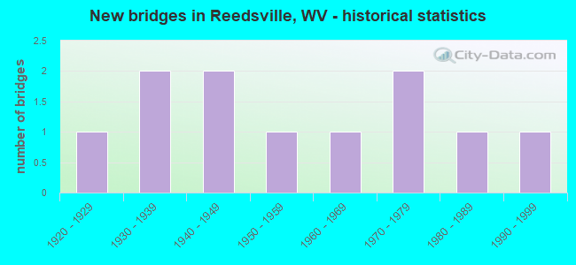
- New bridges - historical statistics
- 11920-1929
- 21930-1939
- 21940-1949
- 11950-1959
- 11960-1969
- 21970-1979
- 11980-1989
- 11990-1999


- Bridge Condition - Deck
- 33.3%Good
- 16.7%Satisfactory
- 16.7%Fair
- 16.7%Poor
- 16.7%Serious

- Bridge Condition - Superstructure
- 12.5%Good
- 12.5%Satisfactory
- 37.5%Fair
- 12.5%Poor
- 25.0%Serious

- Bridge Condition - Substructure
- 12.5%Good
- 37.5%Satisfactory
- 37.5%Fair
- 12.5%Poor

- Bridge Condition - Channel
- 27.3%Good
- 45.5%Satisfactory
- 9.1%Fair
- 18.2%Poor

- Bridge Condition - Culverts
- 33.3%Satisfactory
- 66.7%Poor
Find on map >> Show street view
Structure Number: 39A016, Location: 0.07 MI EAST CO RT 27/3 (Lat: 39.528900, Lng: -79.805281), Route carried "on" structure: State highway 700, Year Built: 1920, Status: Open, Structure Length: 0.79m (2.59ft), Average Daily Traffic: 8,200 (year 2019), Truck Traffic: 11%, Average Future Daily Traffic: 8,610 (year 2041), Features Intersected: DILLAN CREEK, Facility Carried by Structure: WV ROUTE 7
Minimum Vertical Clearance: 30+ m (98+ ft), Kilometerpoint: 6.405, Lanes on structure: 2, Base Highway Network: Yes, Owner: State Highway Agency, Approaching Roadway Width: 8.5m (27.9ft), Skew: 1 degrees, Material/Design: Concrete, Design/Construction: Arch - Deck, Number Of Spans In Main Unit: 1, Length of Maximum Span: 7.9m (25.9ft), Curb-To-Curb Width: 10.9m (35.8ft), Out-to-Out Width: 11.7m (38.4ft)
Condition: Superstructure: Satisfactory, Substructure: Satisfactory, Channel: Good, Operating Rating: 63.5 metric tons, Method Used To Determine Operating Rating: Field evaluation and documented engineering judgment, Inventory Rating: 29.0 metric tons, Method Used To Determine Inventory Rating: Field evaluation and documented engineering judgment, Structural Evaluation: Equal to present minimum criteria, Deck Geometry: Meets minimum limits, Waterway Adequacy: Equal to present minimum criteria, Approach Roadway Alignment: Equal to present desirable criteria, Designated Inspection Frequency: Every 24 months, Inspection Date: March 2021
Find on map >> Show street view
Structure Number: 39A023, Location: 0.30 MI EAST WV RT 7 (Lat: 39.529189, Lng: -79.796939), Route carried "on" structure: County highway 703, Year Built: 1987, Status: Posted for load, Structure Length: 0.74m (2.43ft), Average Daily Traffic: 100 (year 2019), Average Future Daily Traffic: 140 (year 2041), Design Load: HS 20, Features Intersected: DILLAN CREEK, Facility Carried by Structure: PRESTON CO RT 7/3
Minimum Vertical Clearance: 30+ m (98+ ft), Kilometerpoint: 0.483, Lanes on structure: 1, Owner: State Highway Agency, Approaching Roadway Width: 4.0m (13.1ft), Material/Design: Steel, Design/Construction: Stringer/Multi-beam, Number Of Spans In Main Unit: 1, Length of Maximum Span: 6.6m (21.7ft), Curb-To-Curb Width: 3.6m (11.8ft), Out-to-Out Width: 3.6m (11.8ft)
Condition: Deck: Satisfactory, Superstructure: Fair, Substructure: Fair, Channel: Poor, Operating Rating: 46.3 metric tons, Method Used To Determine Operating Rating: Load Factor (LF), Inventory Rating: 27.2 metric tons, Method Used To Determine Inventory Rating: Load Factor (LF), Structural Evaluation: Somewhat better than minimum adequacy, Deck Geometry: High priority of corrective action, Waterway Adequacy: Better than present minimum criteria, Approach Roadway Alignment: Somewhat better than minimum adequacy, Length Of Structure Improvement: 1.31m (4.30ft), Designated Inspection Frequency: Every 24 months, Inspection Date: May 2021, Bridge Improvement Cost: $203,000, Roadway Improvement Cost: $171,000, Total Project Cost: $414,000 ( Estimate for 2021), Deck Structure Type: Wood or Timber, Wearing Surface/Protective System: Wearing Surface: Bituminous
Find on map >> Show street view
Structure Number: 39A065, Location: 0.63 MI EAST CO RT 27/2 (Lat: 39.516600, Lng: -79.809961), Route carried "on" structure: County highway 2700, Year Built: 1967, Status: Open, Structure Length: 1.30m (4.27ft), Average Daily Traffic: 1,900 (year 2018), Truck Traffic: 13%, Average Future Daily Traffic: 2,425 (year 2038), Features Intersected: DECKERS CREEK, Facility Carried by Structure: PRESTON CO RT 27
Minimum Vertical Clearance: 30+ m (98+ ft), Kilometerpoint: 1.255, Lanes on structure: 2, Owner: State Highway Agency, Approaching Roadway Width: 7.6m (24.9ft), Skew: 2 degrees, Material/Design: Steel, Design/Construction: Stringer/Multi-beam, Number Of Spans In Main Unit: 1, Length of Maximum Span: 11.4m (37.4ft), Curb-To-Curb Width: 6.9m (22.6ft), Out-to-Out Width: 7.3m (24.0ft)
Condition: Deck: Good, Superstructure: Poor, Substructure: Satisfactory, Channel: Fair, Operating Rating: 62.6 metric tons, Method Used To Determine Operating Rating: Load Factor (LF), Inventory Rating: 38.1 metric tons, Method Used To Determine Inventory Rating: Load Factor (LF), Structural Evaluation: Meets minimum limits, Deck Geometry: High priority of corrective action, Waterway Adequacy: Somewhat better than minimum adequacy, Approach Roadway Alignment: Better than present minimum criteria, Length Of Structure Improvement: 2.01m (6.59ft), Designated Inspection Frequency: Every 24 months, Inspection Date: August 2020, Bridge Improvement Cost: $254,000, Roadway Improvement Cost: $222,000, Total Project Cost: $568,000 ( Estimate for 2020), Deck Structure Type: Concrete Cast-file-Place, Wearing Surface/Protective System: Wearing Surface: Bituminous
Find on map >> Show street view
Structure Number: 39A066, Location: 0.35 MI EAST CO RT 27/2 (Lat: 39.525600, Lng: -79.811850), Route carried "on" structure: County highway 2703, Year Built: 1979, Status: Open, Structure Length: 1.32m (4.33ft), Average Daily Traffic: 100 (year 2019), Average Future Daily Traffic: 140 (year 2041), Features Intersected: DECKERS CREEK, Facility Carried by Structure: PRESTON CO RT 27/3
Minimum Vertical Clearance: 30+ m (98+ ft), Kilometerpoint: 0.563, Lanes on structure: 1, Owner: State Highway Agency, Approaching Roadway Width: 4.9m (16.1ft), Material/Design: Steel continuous, Design/Construction: Stringer/Multi-beam, Number Of Spans In Main Unit: 1, Number Of Approach Spans: 1, Length of Maximum Span: 5.8m (19.0ft), Curb-To-Curb Width: 4.8m (15.7ft), Out-to-Out Width: 4.9m (16.1ft)
Condition: Deck: Poor, Superstructure: Serious, Substructure: Poor, Channel: Poor, Operating Rating: 16.3 metric tons, Method Used To Determine Operating Rating: Load Factor (LF), Inventory Rating: 10.0 metric tons, Method Used To Determine Inventory Rating: Load Factor (LF), Structural Evaluation: High priority of replacement, Deck Geometry: Equal to present desirable criteria, Waterway Adequacy: Equal to present minimum criteria, Approach Roadway Alignment: Equal to present desirable criteria, Length Of Structure Improvement: 1.89m (6.20ft), Designated Inspection Frequency: Every 24 months, Underwater Inspection Frequency: Every 60 months, Inspection Date: September 2021, Underwater Inspection Date: June 2021, Bridge Improvement Cost: $362,000, Roadway Improvement Cost: $103,000, Total Project Cost: $521,000 ( Estimate for 2021), Deck Structure Type: Wood or Timber, Wearing Surface/Protective System: Wearing Surface: Bituminous
Find on map >> Show street view
Structure Number: 39A071, Location: 0.05 MI NORTH CO RT 92/40 (Lat: 39.500950, Lng: -79.812781), Route carried "on" structure: County highway 9242, Year Built: 1936, Status: Open, Structure Length: 0.77m (2.53ft), Average Daily Traffic: 150 (year 2018), Truck Traffic: 13%, Average Future Daily Traffic: 200 (year 2038), Features Intersected: DECKERS CREEK, Facility Carried by Structure: PRESTON CO 92/42
Minimum Vertical Clearance: 30+ m (98+ ft), Kilometerpoint: 0.692, Lanes on structure: 1, Owner: State Highway Agency, Approaching Roadway Width: 4.6m (15.1ft), Material/Design: Concrete, Design/Construction: Slab, Number Of Spans In Main Unit: 1, Length of Maximum Span: 6.7m (22.0ft), Curb-To-Curb Width: 4.8m (15.7ft), Out-to-Out Width: 5.4m (17.7ft)
Condition: Deck: Fair, Superstructure: Fair, Substructure: Fair, Channel: Good, Operating Rating: 47.2 metric tons, Method Used To Determine Operating Rating: Field evaluation and documented engineering judgment, Inventory Rating: 21.8 metric tons, Method Used To Determine Inventory Rating: Field evaluation and documented engineering judgment, Structural Evaluation: Somewhat better than minimum adequacy, Deck Geometry: High priority of corrective action, Waterway Adequacy: Equal to present desirable criteria, Approach Roadway Alignment: Equal to present desirable criteria, Length Of Structure Improvement: 0.67m (2.20ft), Designated Inspection Frequency: Every 24 months, Inspection Date: June 2020, Bridge Improvement Cost: $214,000, Roadway Improvement Cost: $178,000, Total Project Cost: $473,000 ( Estimate for 2020), Deck Structure Type: Concrete Cast-file-Place, Wearing Surface/Protective System: Wearing Surface: Bituminous
Find on map >> Show street view
Structure Number: 39A085, Location: 0.45 MI SOUTH CO RT 29 (Lat: 39.475711, Lng: -79.849039), Route carried "on" structure: County highway 3305, Year Built: 1952, Status: Posted for load, Structure Length: 0.79m (2.59ft), Average Daily Traffic: 10 (year 2020), Average Future Daily Traffic: 13 (year 2039), Features Intersected: FIELDS CREEK, Facility Carried by Structure: PRESTON CO RT 33/5
Minimum Vertical Clearance: 30+ m (98+ ft), Kilometerpoint: 2.350, Lanes on structure: 1, Owner: State Highway Agency, Approaching Roadway Width: 3.0m (9.8ft), Material/Design: Steel, Number Of Spans In Main Unit: 1, Length of Maximum Span: 7.6m (24.9ft), Curb-To-Curb Width: 3.7m (12.1ft), Out-to-Out Width: 3.7m (12.1ft)
Condition: Deck: Serious, Superstructure: Serious, Substructure: Satisfactory, Channel: Satisfactory, Operating Rating: 10.0 metric tons, Method Used To Determine Operating Rating: Load Factor (LF), Inventory Rating: 6.3 metric tons, Method Used To Determine Inventory Rating: Load Factor (LF), Structural Evaluation: High priority of replacement, Deck Geometry: Meets minimum limits, Waterway Adequacy: Equal to present minimum criteria, Approach Roadway Alignment: Equal to present minimum criteria, Bridge Posting: Required (Relationship of Operating Rating to Maximum Legal Load: > 39.9% below), Length Of Structure Improvement: 1.40m (4.59ft), Designated Inspection Frequency: Every 24 months, Inspection Date: May 2020, Bridge Improvement Cost: $141,000, Roadway Improvement Cost: $108,000, Total Project Cost: $314,000 ( Estimate for 2020), Deck Structure Type: Wood or Timber
Find on map >> Show street view
Structure Number: 39A09, Location: 0.20 MI WEST WV RT 92 (Lat: 39.452231, Lng: -79.823339), Route carried "on" structure: County highway 3500, Year Built: 1992, Status: Open, Structure Length: 1.58m (5.18ft), Average Daily Traffic: 10 (year 2017), Average Future Daily Traffic: 13 (year 2037), Design Load: HS 25 or greater, Features Intersected: BIRDS CREEK, Facility Carried by Structure: PRESTON CO RT 35
Minimum Vertical Clearance: 30+ m (98+ ft), Kilometerpoint: 3.331, Lanes on structure: 1, Owner: State Highway Agency, Approaching Roadway Width: 3.0m (9.8ft), Skew: 2 degrees, Material/Design: Prestressed concrete, Design/Construction: Box Beam or Girders - Multiple, Number Of Spans In Main Unit: 1, Length of Maximum Span: 14.6m (47.9ft), Curb-To-Curb Width: 4.5m (14.8ft), Out-to-Out Width: 4.6m (15.1ft)
Condition: Deck: Good, Superstructure: Good, Substructure: Good, Channel: Good, Operating Rating: 88.9 metric tons, Method Used To Determine Operating Rating: Load Factor (LF), Inventory Rating: 58.0 metric tons, Method Used To Determine Inventory Rating: Load Factor (LF), Structural Evaluation: Better than present minimum criteria, Deck Geometry: Equal to present minimum criteria, Waterway Adequacy: Equal to present desirable criteria, Approach Roadway Alignment: Equal to present desirable criteria, Designated Inspection Frequency: Every 48 months, Inspection Date: May 2019, Deck Structure Type: Other, Wearing Surface/Protective System: Deck Protection: Epoxy Coated Reinforcing
Find on map >> Show street view
Structure Number: 39A169, Location: 0.26 MI SOUTH CO RT 58 (Lat: 39.449550, Lng: -79.815081), Route carried "on" structure: State highway 9200, Year Built: 1940, Status: Open, Structure Length: 0.95m (3.12ft), Average Daily Traffic: 2,900 (year 2019), Truck Traffic: 11%, Average Future Daily Traffic: 3,050 (year 2041), Features Intersected: BIRDS CREEK, Facility Carried by Structure: WV ROUTE 92
Minimum Vertical Clearance: 30+ m (98+ ft), Kilometerpoint: 21.066, Lanes on structure: 2, Owner: State Highway Agency, Approaching Roadway Width: 9.1m (29.9ft), Material/Design: Concrete continuous, Design/Construction: Culvert, Number Of Spans In Main Unit: 2, Length of Maximum Span: 4.6m (15.1ft)
Condition: Channel: Satisfactory, Culverts: Poor, Operating Rating: 63.5 metric tons, Method Used To Determine Operating Rating: Field evaluation and documented engineering judgment, Inventory Rating: 29.0 metric tons, Method Used To Determine Inventory Rating: Field evaluation and documented engineering judgment, Structural Evaluation: Meets minimum limits, Waterway Adequacy: Equal to present desirable criteria, Approach Roadway Alignment: Better than present minimum criteria, Designated Inspection Frequency: Every 24 months, Inspection Date: March 2021
Find on map >> Show street view
Structure Number: 39A17, Location: 0.09 MI NORTH CO RT 35 (Lat: 39.453939, Lng: -79.822469), Route carried "on" structure: State highway 9200, Year Built: 1940, Status: Open, Structure Length: 1.10m (3.61ft), Average Daily Traffic: 2,900 (year 2019), Truck Traffic: 11%, Average Future Daily Traffic: 3,045 (year 2041), Features Intersected: SQUIRES RUN, Facility Carried by Structure: WV ROUTE 92
Minimum Vertical Clearance: 30+ m (98+ ft), Kilometerpoint: 22.048, Lanes on structure: 2, Owner: State Highway Agency, Approaching Roadway Width: 9.1m (29.9ft), Skew: 3 degrees, Material/Design: Concrete continuous, Design/Construction: Culvert, Number Of Spans In Main Unit: 2, Length of Maximum Span: 5.3m (17.4ft)
Condition: Channel: Satisfactory, Culverts: Poor, Operating Rating: 57.1 metric tons, Method Used To Determine Operating Rating: Field evaluation and documented engineering judgment, Inventory Rating: 26.3 metric tons, Method Used To Determine Inventory Rating: Field evaluation and documented engineering judgment, Structural Evaluation: Meets minimum limits, Waterway Adequacy: Equal to present minimum criteria, Approach Roadway Alignment: Better than present minimum criteria, Length Of Structure Improvement: 1.10m (3.61ft), Designated Inspection Frequency: Every 24 months, Inspection Date: April 2021, Bridge Improvement Cost: $138,000, Roadway Improvement Cost: $74,000, Total Project Cost: $244,000 ( Estimate for 2021)
Find on map >> Show street view
Structure Number: 39A173, Location: 0.25 MI NORTH WV RT 92 (Lat: 39.498400, Lng: -79.817831), Route carried "on" structure: County highway 9230, Year Built: 1936, Status: Open, Structure Length: 0.74m (2.43ft), Average Daily Traffic: 100 (year 2019), Average Future Daily Traffic: 140 (year 2041), Features Intersected: DECKERS CREEK, Facility Carried by Structure: COUNTY ROUTE 92/30
Minimum Vertical Clearance: 30+ m (98+ ft), Kilometerpoint: 0.402, Lanes on structure: 1, Owner: State Highway Agency, Approaching Roadway Width: 5.2m (17.1ft), Skew: 2 degrees, Material/Design: Concrete, Design/Construction: Slab, Number Of Spans In Main Unit: 1, Length of Maximum Span: 6.2m (20.3ft), Curb or Sidewalk Widths: Left: 0.1m (0.3ft), Right: 0.1m (0.3ft), Curb-To-Curb Width: 4.8m (15.7ft), Out-to-Out Width: 5.4m (17.7ft)
Condition: Superstructure: Fair, Substructure: Fair, Channel: Satisfactory, Operating Rating: 47.2 metric tons, Method Used To Determine Operating Rating: Field evaluation and documented engineering judgment, Inventory Rating: 21.8 metric tons, Method Used To Determine Inventory Rating: Field evaluation and documented engineering judgment, Structural Evaluation: Somewhat better than minimum adequacy, Deck Geometry: Equal to present desirable criteria, Waterway Adequacy: Better than present minimum criteria, Approach Roadway Alignment: Equal to present desirable criteria, Length Of Structure Improvement: 0.64m (2.10ft), Designated Inspection Frequency: Every 24 months, Inspection Date: March 2021, Bridge Improvement Cost: $225,000, Roadway Improvement Cost: $179,000, Total Project Cost: $486,000 ( Estimate for 2019), Deck Structure Type: Concrete Cast-file-Place, Wearing Surface/Protective System: Wearing Surface: Bituminous
Find on map >> Show street view
Structure Number: 39A189, Location: 0.45 MI WEST WV RT 7 (Lat: 39.528119, Lng: -79.806539), Route carried "on" structure: County highway 2703, Year Built: 1970, Status: Open, Structure Length: 0.79m (2.59ft), Average Daily Traffic: 100 (year 2018), Average Future Daily Traffic: 130 (year 2038), Features Intersected: DILLAN CREEK, Facility Carried by Structure: PRESTON CO RT 27/3
Minimum Vertical Clearance: 30+ m (98+ ft), Kilometerpoint: 1.223, Lanes on structure: 2, Owner: State Highway Agency, Approaching Roadway Width: 4.9m (16.1ft), Skew: 1 degrees, Material/Design: Concrete, Design/Construction: Culvert, Number Of Spans In Main Unit: 1, Length of Maximum Span: 7.9m (25.9ft)
Condition: Channel: Satisfactory, Culverts: Satisfactory, Operating Rating: 71.7 metric tons, Method Used To Determine Operating Rating: Field evaluation and documented engineering judgment, Inventory Rating: 32.7 metric tons, Method Used To Determine Inventory Rating: Field evaluation and documented engineering judgment, Structural Evaluation: Equal to present minimum criteria, Waterway Adequacy: Somewhat better than minimum adequacy, Approach Roadway Alignment: Equal to present desirable criteria, Designated Inspection Frequency: Every 24 months, Inspection Date: April 2020