Bridge Statistics for Reeltown, Alabama (AL)
Condition, Traffic, Stress, Structural Evaluation, Project Costs
- National Bridge Inventory (NBI) Statistics
- 13Number of bridges
- 148ft / 44.7mTotal length
- $16,585,000Total costs
- 27,379Total average daily traffic
- 3,499Total average daily truck traffic
- National Bridge Inventory (NBI) Registered Bridges for Reeltown
- No street view available for this location
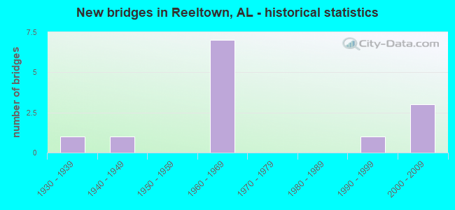
- New bridges - historical statistics
- 11930-1939
- 11940-1949
- 71960-1969
- 11990-1999
- 32000-2009

- Reconstructed bridges - Historical Statistics
- 11950-1959
- 01960-1969
- 01970-1979
- 11980-1989


- Bridge Condition - Deck
- 28.6%Very good
- 42.9%Satisfactory
- 14.3%Fair
- 14.3%Poor

- Bridge Condition - Superstructure
- 14.3%Very good
- 42.9%Good
- 14.3%Satisfactory
- 14.3%Poor
- 14.3%Serious

- Bridge Condition - Substructure
- 28.6%Very good
- 57.1%Satisfactory
- 14.3%Serious

- Bridge Condition - Channel
- 8.3%Very good
- 41.7%Good
- 33.3%Satisfactory
- 16.7%Fair

- Bridge Condition - Culverts
- 20.0%Very good
- 20.0%Good
- 60.0%Fair
Find on map >> Show street view
Structure Number: 2576, Location: 0.7 MI N JCT SR 14 (Lat: 32.569244, Lng: -85.817311), Route carried "on" structure: State highway 49, Year Built: 1941, Status: Open, Structure Length: 1.33m (4.36ft), Average Daily Traffic: 1,964 (year 2018), Truck Traffic: 11%, Average Future Daily Traffic: 2,750 (year 2038), Design Load: H 15, Features Intersected: STONE CREEK
Minimum Vertical Clearance: 30+ m (98+ ft), Kilometerpoint: 15.651, Lanes on structure: 2, Base Highway Network: Yes, Owner: State Highway Agency, Approaching Roadway Width: 7.3m (24.0ft), Skew: 4 degrees, Material/Design: Concrete, Design/Construction: Culvert, Number Of Spans In Main Unit: 3, Length of Maximum Span: 4.2m (13.8ft), Curb-To-Curb Width: 9.1m (29.9ft), Out-to-Out Width: 9.8m (32.2ft)
Condition: Channel: Satisfactory, Culverts: Fair, Operating Rating: 43.7 metric tons, Method Used To Determine Operating Rating: Load Factor (LF), Inventory Rating: 26.2 metric tons, Method Used To Determine Inventory Rating: Load Factor (LF), Structural Evaluation: Somewhat better than minimum adequacy, Deck Geometry: Somewhat better than minimum adequacy, Waterway Adequacy: Equal to present minimum criteria, Approach Roadway Alignment: Equal to present minimum criteria, Length Of Structure Improvement: 2.00m (6.56ft), Designated Inspection Frequency: Every 24 months, Inspection Date: July 2020, Bridge Improvement Cost: $369,000, Roadway Improvement Cost: $37,000, Total Project Cost: $406,000 ( Estimate for 2022), Deck Structure Type: Concrete Cast-file-Place
Find on map >> Show street view
Structure Number: 6756, Location: 3.8 MI N ALA NO 49 (Lat: 32.640219, Lng: -85.844653), Route carried "on" structure: County highway 46, Year Built: 1995, Status: Open, Structure Length: 9.14m (29.99ft), Average Daily Traffic: 405 (year 2008), Truck Traffic: 7%, Average Future Daily Traffic: 625 (year 2030), Design Load: HS 20, Features Intersected: SOUGHATCHEE CREEK, Facility Carried by Structure: LOVELADY RD
Minimum Vertical Clearance: 30+ m (98+ ft), Kilometerpoint: 0.010, Lanes on structure: 2, Owner: County Highway Agency, Approaching Roadway Width: 8.5m (27.9ft), Material/Design: Prestressed concrete, Design/Construction: Stringer/Multi-beam, Number Of Spans In Main Unit: 1, Number Of Approach Spans: 2, Length of Maximum Span: 36.6m (120.1ft), Curb-To-Curb Width: 8.5m (27.9ft), Out-to-Out Width: 9.4m (30.8ft)
Condition: Deck: Very good, Superstructure: Very good, Substructure: Very good, Channel: Good, Operating Rating: 73.7 metric tons, Method Used To Determine Operating Rating: Load Factor (LF), Inventory Rating: 45.4 metric tons, Method Used To Determine Inventory Rating: Load Factor (LF), Structural Evaluation: Equal to present desirable criteria, Deck Geometry: Somewhat better than minimum adequacy, Waterway Adequacy: Equal to present desirable criteria, Approach Roadway Alignment: Equal to present desirable criteria, Length Of Structure Improvement: 10.11m (33.17ft), Designated Inspection Frequency: Every 24 months, Inspection Date: October 2020, Bridge Improvement Cost: $2,079,000, Roadway Improvement Cost: $208,000, Total Project Cost: $2,287,000 ( Estimate for 2022), Deck Structure Type: Concrete Cast-file-Place, Wearing Surface/Protective System: Wearing Surface: Bituminous
Find on map >> Show street view
Structure Number: 7418, Location: .6M EAST CO RT#1 (Lat: 32.340000, Lng: -87.435000), Route carried "on" structure: County highway 50, Year Built: 1961, Status: Open, Structure Length: 1.46m (4.79ft), Average Daily Traffic: 125 (year 1993), Truck Traffic: 1%, Average Future Daily Traffic: 140 (year 2032), Design Load: H 10, Features Intersected: ROGERS CREEK
Minimum Vertical Clearance: 30+ m (98+ ft), Kilometerpoint: 0.010, Lanes on structure: 2, Owner: County Highway Agency, Approaching Roadway Width: 5.5m (18.0ft), Material/Design: Concrete, Design/Construction: Culvert, Number Of Spans In Main Unit: 4, Length of Maximum Span: 3.1m (10.2ft), Out-to-Out Width: 9.9m (32.5ft)
Condition: Channel: Fair, Culverts: Fair, Operating Rating: 88.9 metric tons, Method Used To Determine Operating Rating: Load Factor (LF), Inventory Rating: 75.1 metric tons, Method Used To Determine Inventory Rating: Load Factor (LF), Structural Evaluation: Somewhat better than minimum adequacy, Waterway Adequacy: Better than present minimum criteria, Approach Roadway Alignment: Equal to present minimum criteria, Length Of Structure Improvement: 2.14m (7.02ft), Designated Inspection Frequency: Every 24 months, Inspection Date: August 2021, Bridge Improvement Cost: $592,000, Roadway Improvement Cost: $59,000, Total Project Cost: $651,000 ( Estimate for 2022)
Find on map >> Show street view
Structure Number: 742, Location: 0.5 MI E OF US 11 (Lat: 34.498333, Lng: -85.691667), Route carried "on" structure: Other road , Year Built: 1961, Status: Closed, Structure Length: 1.22m (4.00ft), Average Daily Traffic: 55 (year 1995), Average Future Daily Traffic: 80 (year 2015), Design Load: H 10, Features Intersected: WILLS CREEK, Facility Carried by Structure: FAIRWAY RD
Minimum Vertical Clearance: 3.35m (10.99ft), Kilometerpoint: 0.161, Lanes on structure: 1, Owner: City or Municipal Highway Agency, Maintenance Responsibility: Private, Approaching Roadway Width: 3.7m (12.1ft), Material/Design: Steel, Design/Construction: Stringer/Multi-beam, Number Of Spans In Main Unit: 1, Length of Maximum Span: 12.2m (40.0ft), Curb-To-Curb Width: 3.6m (11.8ft), Out-to-Out Width: 3.6m (11.8ft)
Condition: Deck: Poor, Superstructure: Serious, Substructure: Serious, Channel: Fair, Waterway Adequacy: Meets minimum limits, Approach Roadway Alignment: High priority of replacement, Bridge Posting: Required (Relationship of Operating Rating to Maximum Legal Load: > 39.9% below), Length Of Structure Improvement: 1.89m (6.20ft), Designated Inspection Frequency: Every 24 months, Other Special Inspection Frequency: Every 12 months, Inspection Date: Febuary 1995, Other Special Inspection Date: Febuary 1995, Bridge Improvement Cost: $143,000, Roadway Improvement Cost: $14,000, Total Project Cost: $157,000 ( Estimate for 2022), Deck Structure Type: Concrete Cast-file-Place
Find on map >> Show street view
Structure Number: 7459, Location: 1.2 MI E CARROLLTON (Lat: 33.261867, Lng: -88.079300), Route carried "on" structure: State highway 86, Year Built: 1961, Status: Open, Structure Length: 12.47m (40.91ft), Average Daily Traffic: 3,058 (year 2020), Truck Traffic: 9%, Average Future Daily Traffic: 3,514 (year 2040), Design Load: H 20, Features Intersected: Lubbub Creek
Minimum Vertical Clearance: 30+ m (98+ ft), Kilometerpoint: 24.208, Lanes on structure: 2, Owner: State Highway Agency, Approaching Roadway Width: 9.1m (29.9ft), Material/Design: Concrete, Design/Construction: Tee Beam, Number Of Spans In Main Unit: 12, Length of Maximum Span: 10.4m (34.1ft), Curb or Sidewalk Widths: Left: 0.5m (1.6ft), Right: 0.5m (1.6ft), Curb-To-Curb Width: 7.3m (24.0ft), Out-to-Out Width: 8.9m (29.2ft)
Condition: Deck: Satisfactory, Superstructure: Satisfactory, Substructure: Satisfactory, Channel: Satisfactory, Operating Rating: 40.8 metric tons, Method Used To Determine Operating Rating: Load Factor (LF), Inventory Rating: 24.5 metric tons, Method Used To Determine Inventory Rating: Load Factor (LF), Structural Evaluation: Equal to present minimum criteria, Deck Geometry: High priority of replacement, Waterway Adequacy: Equal to present minimum criteria, Approach Roadway Alignment: Equal to present desirable criteria, Length Of Structure Improvement: 13.30m (43.64ft), Designated Inspection Frequency: Every 24 months, Underwater Inspection Frequency: Every 24 months, Inspection Date: August 2020, Underwater Inspection Date: July 2020, Bridge Improvement Cost: $2,646,000, Roadway Improvement Cost: $265,000, Total Project Cost: $2,911,000 ( Estimate for 2022), Deck Structure Type: Concrete Cast-file-Place
Find on map >> Show street view
Structure Number: 75, Location: 0.82 M E OF AL. NO.49 (Lat: 32.533719, Lng: -85.800569), Route carried "on" structure: County highway 205, Year Built: 1961, Status: Open, Structure Length: 1.16m (3.81ft), Average Daily Traffic: 175 (year 2008), Truck Traffic: 7%, Average Future Daily Traffic: 270 (year 2030), Features Intersected: WAUXAMAKA CREEK, Facility Carried by Structure: E. GANTS MILL RD
Minimum Vertical Clearance: 30+ m (98+ ft), Kilometerpoint: 0.010, Lanes on structure: 2, Owner: County Highway Agency, Approaching Roadway Width: 8.8m (28.9ft), Material/Design: Concrete, Design/Construction: Channel Beam, Number Of Spans In Main Unit: 1, Number Of Approach Spans: 1, Length of Maximum Span: 5.8m (19.0ft), Curb-To-Curb Width: 6.7m (22.0ft), Out-to-Out Width: 7.6m (24.9ft)
Condition: Deck: Satisfactory, Superstructure: Good, Substructure: Satisfactory, Channel: Satisfactory, Operating Rating: 71.4 metric tons, Method Used To Determine Operating Rating: Allowable Stress (AS), Inventory Rating: 47.3 metric tons, Method Used To Determine Inventory Rating: Allowable Stress (AS), Structural Evaluation: Equal to present minimum criteria, Waterway Adequacy: Equal to present minimum criteria, Approach Roadway Alignment: Somewhat better than minimum adequacy, Length Of Structure Improvement: 1.84m (6.04ft), Designated Inspection Frequency: Every 24 months, Inspection Date: November 2020, Bridge Improvement Cost: $302,000, Roadway Improvement Cost: $30,000, Total Project Cost: $332,000 ( Estimate for 2022), Deck Structure Type: Concrete Cast-file-Place
Find on map >> Show street view
Structure Number: 7521, Location: 1.4 M E CO RD 046 (Lat: 32.652194, Lng: -85.832447), Route carried "on" structure: County highway 60, Year Built: 1930, Year Reconstructed: 1962, Status: Posted for load, Structure Length: 1.60m (5.25ft), Average Daily Traffic: 220 (year 2008), Average Future Daily Traffic: 340 (year 2030), Features Intersected: BUCK CREEK, Facility Carried by Structure: BUCK CREEK RD
Minimum Vertical Clearance: 30+ m (98+ ft), Kilometerpoint: 0.010, Lanes on structure: 1, Owner: County Highway Agency, Approaching Roadway Width: 5.2m (17.1ft), Material/Design: Steel, Design/Construction: Truss - Thru, Number Of Spans In Main Unit: 1, Length of Maximum Span: 16.0m (52.5ft), Curb-To-Curb Width: 3.7m (12.1ft), Out-to-Out Width: 4.3m (14.1ft)
Condition: Deck: Fair, Superstructure: Poor, Substructure: Satisfactory, Channel: Good, Operating Rating: 5.4 metric tons, Method Used To Determine Operating Rating: Load Factor (LF), Inventory Rating: 3.6 metric tons, Method Used To Determine Inventory Rating: Load Factor (LF), Structural Evaluation: High priority of replacement, Deck Geometry: High priority of replacement, Waterway Adequacy: Equal to present minimum criteria, Approach Roadway Alignment: Somewhat better than minimum adequacy, Bridge Posting: Required (Relationship of Operating Rating to Maximum Legal Load: > 39.9% below), Length Of Structure Improvement: 2.29m (7.51ft), Designated Inspection Frequency: Every 24 months, Critical Feature Inspection Frequency: Every 12 months, Other Special Inspection Frequency: Every 12 months, Inspection Date: October 2020, Critical Feature Inspection Date: October 2021, Other Special Inspection Date: October 2021, Bridge Improvement Cost: $219,000, Roadway Improvement Cost: $22,000, Total Project Cost: $241,000 ( Estimate for 2022), Deck Structure Type: Wood or Timber, Wearing Surface/Protective System: Wearing Surface: Wood or Timber
Find on map >> Show street view
Structure Number: 7966, Location: 0.6 MI NORTH ALA 14 (Lat: 32.569628, Lng: -85.809969), Route carried "on" structure: County highway 25, Year Built: 1963, Status: Open, Structure Length: 0.67m (2.20ft), Average Daily Traffic: 315 (year 2008), Truck Traffic: 7%, Average Future Daily Traffic: 485 (year 2030), Features Intersected: STONE CREEK, Facility Carried by Structure: LOWE RD
Minimum Vertical Clearance: 30+ m (98+ ft), Kilometerpoint: 0.010, Lanes on structure: 2, Owner: County Highway Agency, Approaching Roadway Width: 9.1m (29.9ft), Material/Design: Concrete, Design/Construction: Culvert, Number Of Spans In Main Unit: 2, Length of Maximum Span: 3.0m (9.8ft)
Condition: Channel: Good, Culverts: Good, Operating Rating: 63.5 metric tons, Method Used To Determine Operating Rating: Load Factor (LF), Inventory Rating: 38.1 metric tons, Method Used To Determine Inventory Rating: Load Factor (LF), Structural Evaluation: Better than present minimum criteria, Waterway Adequacy: Better than present minimum criteria, Approach Roadway Alignment: Equal to present minimum criteria, Length Of Structure Improvement: 1.30m (4.27ft), Designated Inspection Frequency: Every 24 months, Inspection Date: November 2020, Bridge Improvement Cost: $601,000, Roadway Improvement Cost: $60,000, Total Project Cost: $661,000 ( Estimate for 2022), Deck Structure Type: Concrete Cast-file-Place, Wearing Surface/Protective System: Wearing Surface: Bituminous
Find on map >> Show street view
Structure Number: 13813, Location: CR 1494 (Lat: 34.294769, Lng: -86.740678), Route carried "on" structure: County highway , Year Built: 1962, Year Reconstructed: 1986, Status: Open, Structure Length: 0.70m (2.30ft), Average Daily Traffic: 20 (year 1991), Average Future Daily Traffic: 20 (year 2036), Features Intersected: BRANCH, Facility Carried by Structure: cr 1494
Minimum Vertical Clearance: 30+ m (98+ ft), Kilometerpoint: 0.010, Lanes on structure: 2, Owner: County Highway Agency, Approaching Roadway Width: 6.7m (22.0ft), Skew: 3 degrees, Material/Design: Steel, Design/Construction: Stringer/Multi-beam, Number Of Spans In Main Unit: 1, Length of Maximum Span: 7.0m (23.0ft), Curb-To-Curb Width: 8.0m (26.2ft), Out-to-Out Width: 8.1m (26.6ft)
Condition: Deck: Satisfactory, Superstructure: Good, Substructure: Satisfactory, Channel: Satisfactory, Operating Rating: 86.2 metric tons, Method Used To Determine Operating Rating: Load Factor (LF), Inventory Rating: 61.3 metric tons, Method Used To Determine Inventory Rating: Load Factor (LF), Structural Evaluation: Equal to present minimum criteria, Deck Geometry: Equal to present minimum criteria, Waterway Adequacy: Somewhat better than minimum adequacy, Approach Roadway Alignment: Equal to present minimum criteria, Length Of Structure Improvement: 1.34m (4.40ft), Designated Inspection Frequency: Every 24 months, Inspection Date: September 2020, Bridge Improvement Cost: $239,000, Roadway Improvement Cost: $24,000, Total Project Cost: $263,000 ( Estimate for 2022), Deck Structure Type: Concrete Cast-file-Place
Find on map >> Show street view
Structure Number: 18025, Location: 5.6 MI N JCT SR14 (Lat: 32.631583, Lng: -85.799167), Route carried "on" structure: State highway 49, Year Built: 2006, Status: Open, Structure Length: 12.62m (41.40ft), Average Daily Traffic: 1,961 (year 2020), Truck Traffic: 6%, Average Future Daily Traffic: 2,745 (year 2040), Design Load: HS 20, Features Intersected: SAUGAHATCHEE CREEK
Minimum Vertical Clearance: 30+ m (98+ ft), Kilometerpoint: 23.451, Lanes on structure: 2, Base Highway Network: Yes, Owner: State Highway Agency, Approaching Roadway Width: 11.2m (36.7ft), Skew: 2 degrees, Material/Design: Prestressed concrete, Design/Construction: Stringer/Multi-beam, Number Of Spans In Main Unit: 3, Length of Maximum Span: 42.1m (138.1ft), Curb-To-Curb Width: 13.3m (43.6ft), Out-to-Out Width: 14.2m (46.6ft)
Condition: Deck: Very good, Superstructure: Good, Substructure: Very good, Channel: Good, Operating Rating: 88.9 metric tons, Method Used To Determine Operating Rating: Load Factor (LF), Inventory Rating: 47.8 metric tons, Method Used To Determine Inventory Rating: Load Factor (LF), Structural Evaluation: Better than present minimum criteria, Deck Geometry: Better than present minimum criteria, Waterway Adequacy: Equal to present desirable criteria, Approach Roadway Alignment: Equal to present desirable criteria, Length Of Structure Improvement: 13.45m (44.13ft), Designated Inspection Frequency: Every 24 months, Inspection Date: Febuary 2022, Bridge Improvement Cost: $4,243,000, Roadway Improvement Cost: $424,000, Total Project Cost: $4,667,000 ( Estimate for 2022), Deck Structure Type: Concrete Cast-file-Place
Find on map >> Show street view
Structure Number: 18384, Location: 1.0 MI N OF AL HWY 49S (Lat: 32.630878, Lng: -85.779397), Route carried "on" structure: County highway 86, Year Built: 2002, Status: Open, Structure Length: 1.37m (4.49ft), Average Daily Traffic: 505 (year 2008), Truck Traffic: 7%, Average Future Daily Traffic: 780 (year 2030), Design Load: HS 20, Features Intersected: MITCHELL CREEK, Facility Carried by Structure: S.CHURCHILL RD
Minimum Vertical Clearance: 30+ m (98+ ft), Kilometerpoint: 0.016, Lanes on structure: 2, Owner: County Highway Agency, Approaching Roadway Width: 10.7m (35.1ft), Material/Design: Concrete, Design/Construction: Culvert, Number Of Spans In Main Unit: 3, Length of Maximum Span: 4.3m (14.1ft)
Condition: Channel: Very good, Culverts: Very good, Operating Rating: 88.9 metric tons, Method Used To Determine Operating Rating: Load Factor (LF), Inventory Rating: 84.7 metric tons, Method Used To Determine Inventory Rating: Load Factor (LF), Structural Evaluation: Equal to present desirable criteria, Waterway Adequacy: Equal to present desirable criteria, Approach Roadway Alignment: Equal to present desirable criteria, Length Of Structure Improvement: 2.05m (6.73ft), Designated Inspection Frequency: Every 24 months, Inspection Date: December 2020, Bridge Improvement Cost: $709,000, Roadway Improvement Cost: $71,000, Total Project Cost: $780,000 ( Estimate for 2022)
Find on map >> Show street view
Structure Number: 19155, Location: 5.9 MI N JCT SR14 (Lat: 32.634431, Lng: -85.796122), Route carried "on" structure: State highway 49, Year Built: 2005, Status: Open, Structure Length: 1.00m (3.28ft), Average Daily Traffic: 1,986 (year 2019), Truck Traffic: 7%, Average Future Daily Traffic: 2,780 (year 2039), Design Load: HS 20, Features Intersected: LEDBETTER CREEK
Minimum Vertical Clearance: 30+ m (98+ ft), Kilometerpoint: 23.916, Lanes on structure: 2, Base Highway Network: Yes, Owner: State Highway Agency, Approaching Roadway Width: 11.3m (37.1ft), Skew: 1 degrees, Material/Design: Concrete, Design/Construction: Culvert, Number Of Spans In Main Unit: 3, Length of Maximum Span: 3.1m (10.2ft)
Condition: Channel: Good, Culverts: Fair, Operating Rating: 88.9 metric tons, Method Used To Determine Operating Rating: Load Factor (LF), Inventory Rating: 88.9 metric tons, Method Used To Determine Inventory Rating: Load Factor (LF), Structural Evaluation: Somewhat better than minimum adequacy, Waterway Adequacy: Equal to present desirable criteria, Approach Roadway Alignment: Equal to present desirable criteria, Length Of Structure Improvement: 1.67m (5.48ft), Designated Inspection Frequency: Every 24 months, Inspection Date: April 2021, Bridge Improvement Cost: $2,935,000, Roadway Improvement Cost: $294,000, Total Project Cost: $3,229,000 ( Estimate for 2022)
Find on map >> Show street view
Structure Number: 7421, Location: 3.5 MI. S. OZARK (Lat: 31.394783, Lng: -85.586550), Route carried "under" structure: US 231, Year Built: 1961, Structure Length: 0. m, Average Daily Traffic: 16,590 (year 2013), Truck Traffic: 16%, Features Intersected: U. S. 231, Facility Carried by Structure: CSXT RAILROAD
Minimum Vertical Clearance: 5.21m (17.09ft), Kilometerpoint: 61.313, Lanes under structure: 4, Material/Design: Steel, Design/Construction: Stringer/Multi-beam, Length of Maximum Span: 16.2m (53.1ft)