Bridge Statistics for Remington, Indiana (IN)
Condition, Traffic, Stress, Structural Evaluation, Project Costs
- National Bridge Inventory (NBI) Statistics
- 39Number of bridges
- 272ft / 83.2mTotal length
- $1,800,000Total costs
- 160,883Total average daily traffic
- 40,200Total average daily truck traffic
- National Bridge Inventory (NBI) Registered Bridges for Remington
- No street view available for this location
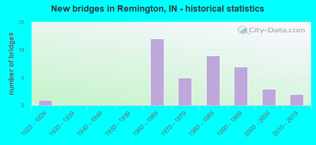
- New bridges - historical statistics
- 11920-1929
- 121960-1969
- 51970-1979
- 91980-1989
- 71990-1999
- 32000-2009
- 22010-2019

- Reconstructed bridges - Historical Statistics
- 11940-1949
- 01950-1959
- 01960-1969
- 01970-1979
- 31980-1989
- 01990-1999
- 02000-2009
- 22010-2019


- Bridge Condition - Deck
- 10.0%Very good
- 30.0%Good
- 46.7%Satisfactory
- 13.3%Fair

- Bridge Condition - Superstructure
- 6.5%Very good
- 45.2%Good
- 38.7%Satisfactory
- 9.7%Fair

- Bridge Condition - Substructure
- 19.4%Very good
- 45.2%Good
- 32.3%Satisfactory
- 3.2%Fair

- Bridge Condition - Channel
- 21.4%Very good
- 14.3%Good
- 39.3%Satisfactory
- 17.9%Fair
- 7.1%Poor

- Bridge Condition - Culverts
- 50.0%Very good
- 50.0%Good
Find on map >> Show street view
Structure Number: 5884, Location: 03.00 W US 231 (Lat: 40.765769, Lng: -87.210869), Route carried "on" structure: US 24, Year Built: 2013, Status: Open, Structure Length: 0.67m (2.20ft), Average Daily Traffic: 3,470 (year 2012), Truck Traffic: 28%, Average Future Daily Traffic: 3,600 (year 2030), Design Load: HL 93, Features Intersected: UNT GUSHWA DITCH
Minimum Vertical Clearance: 30+ m (98+ ft), Kilometerpoint: 7.194, Lanes on structure: 2, Base Highway Network: Yes (, Subroute: 1), Owner: State Highway Agency, Approaching Roadway Width: 7.3m (24.0ft), Material/Design: Concrete, Design/Construction: Culvert, Number Of Spans In Main Unit: 1, Length of Maximum Span: 6.1m (20.0ft), Curb-To-Curb Width: 19.9m (65.3ft), Out-to-Out Width: 21.8m (71.5ft)
Condition: Channel: Very good, Culverts: Very good, Operating Rating: 50.9 metric tons, Method Used To Determine Operating Rating: Load and Resistance Factor Rating (LRFR) rating reported by rating factor(RF) method using HL-93 loadings, Inventory Rating: 39.2 metric tons, Method Used To Determine Inventory Rating: Load and Resistance Factor Rating (LRFR) rating reported by rating factor(RF) method using HL-93 loadings, Structural Evaluation: Equal to present desirable criteria, Deck Geometry: Superior to present desirable criteria, Waterway Adequacy: Superior to present desirable criteria, Approach Roadway Alignment: Equal to present desirable criteria, Designated Inspection Frequency: Every 24 months, Inspection Date: May 2020
Find on map >> Show street view
Structure Number: 5887, Location: 01.50 W US 231 (Lat: 40.765789, Lng: -87.181150), Route carried "on" structure: US 24, Year Built: 2003, Status: Open, Structure Length: 0.70m (2.30ft), Average Daily Traffic: 10,562 (year 2004), Truck Traffic: 5%, Average Future Daily Traffic: 14,882 (year 2030), Design Load: HS 20+Mod, Features Intersected: TRIBUTARY CARPENTER CREE
Minimum Vertical Clearance: 30+ m (98+ ft), Kilometerpoint: 7.194, Lanes on structure: 2, Base Highway Network: Yes (, Subroute: 1), Owner: State Highway Agency, Approaching Roadway Width: 14.9m (48.9ft), Material/Design: Concrete, Design/Construction: Culvert, Number Of Spans In Main Unit: 1, Length of Maximum Span: 7.0m (23.0ft), Curb-To-Curb Width: 15.0m (49.2ft), Out-to-Out Width: 18.0m (59.1ft)
Condition: Channel: Very good, Culverts: Good, Operating Rating: 40.8 metric tons, Method Used To Determine Operating Rating: Allowable Stress (AS), Inventory Rating: 32.7 metric tons, Method Used To Determine Inventory Rating: Allowable Stress (AS), Structural Evaluation: Better than present minimum criteria, Deck Geometry: Superior to present desirable criteria, Waterway Adequacy: Superior to present desirable criteria, Approach Roadway Alignment: Equal to present desirable criteria, Designated Inspection Frequency: Every 24 months, Inspection Date: May 2020
Find on map >> Show street view
Structure Number: 589, Location: 00.36 E US 231 (Lat: 40.765861, Lng: -87.147017), Route carried "on" structure: US 24, Year Built: 1929, Year Reconstructed: 1954, Status: Open, Structure Length: 1.60m (5.25ft), Average Daily Traffic: 10,562 (year 2004), Truck Traffic: 5%, Average Future Daily Traffic: 14,882 (year 2030), Design Load: H 20, Features Intersected: CARPENTER CREEK
Minimum Vertical Clearance: 30+ m (98+ ft), Kilometerpoint: 10.187, Lanes on structure: 2, Base Highway Network: Yes (, Subroute: 1), Owner: State Highway Agency, Approaching Roadway Width: 9.1m (29.9ft), Material/Design: Concrete, Design/Construction: Arch - Deck, Number Of Spans In Main Unit: 1, Length of Maximum Span: 15.2m (49.9ft), Curb-To-Curb Width: 15.2m (49.9ft), Out-to-Out Width: 15.9m (52.2ft)
Condition: Superstructure: Satisfactory, Substructure: Good, Channel: Satisfactory, Inventory Rating: 88.2 metric tons, Method Used To Determine Inventory Rating: Field evaluation and documented engineering judgment, Structural Evaluation: Equal to present minimum criteria, Deck Geometry: Superior to present desirable criteria, Waterway Adequacy: Equal to present minimum criteria, Approach Roadway Alignment: Equal to present desirable criteria, Designated Inspection Frequency: Every 24 months, Inspection Date: May 2020
Find on map >> Show street view
Structure Number: 3799, Location: 01.20 S US 24 (Lat: 40.751111, Lng: -87.107650), Route carried "on" structure: Alternate County highway , Year Built: 1968, Status: Open, Structure Length: 8.27m (27.13ft), Average Daily Traffic: 400 (year 2010), Truck Traffic: 5%, Average Future Daily Traffic: 600 (year 2034), Design Load: HS 20, Features Intersected: I-65 NB/SB, Facility Carried by Structure: WOLCOTT RD/CR 1800
Minimum Vertical Clearance: 30+ m (98+ ft), Kilometerpoint: 0.000, Lanes on structure: 2, Lanes under structure: 4, Owner: State Highway Agency, Approaching Roadway Width: 6.1m (20.0ft), Skew: 3 degrees, Material/Design: Steel continuous, Design/Construction: Stringer/Multi-beam, Number Of Spans In Main Unit: 2, Length of Maximum Span: 40.4m (132.5ft), Curb or Sidewalk Widths: Left: 0.1m (0.3ft), Right: 0.1m (0.3ft), Curb-To-Curb Width: 8.6m (28.2ft), Out-to-Out Width: 9.6m (31.5ft)
Condition: Deck: Good, Superstructure: Good, Substructure: Good, Operating Rating: 41.1 metric tons, Method Used To Determine Operating Rating: Load and Resistance Factor Rating (LRFR) rating reported by rating factor(RF) method using HL-93 loadings, Inventory Rating: 31.8 metric tons, Method Used To Determine Inventory Rating: Load and Resistance Factor Rating (LRFR) rating reported by rating factor(RF) method using HL-93 loadings, Structural Evaluation: Better than present minimum criteria, Deck Geometry: Equal to present minimum criteria, Underclear: Somewhat better than minimum adequacy, Approach Roadway Alignment: Equal to present desirable criteria, Designated Inspection Frequency: Every 24 months, Inspection Date: August 2021, Deck Structure Type: Concrete Cast-file-Place, Wearing Surface/Protective System: Wearing Surface: Latex Concrete
Find on map >> Show street view
Structure Number: 38, Location: 00.47 S US 24 (Lat: 40.759861, Lng: -87.115650), Route carried "on" structure: Interstate 65, Year Built: 1968, Year Reconstructed: 1994, Status: Open, Structure Length: 5.33m (17.49ft), Average Daily Traffic: 14,828 (year 2004), Truck Traffic: 10%, Average Future Daily Traffic: 26,853 (year 2030), Design Load: HS 20+Mod, Features Intersected: TP&W RR
Minimum Vertical Clearance: 30+ m (98+ ft), Kilometerpoint: 322.625, Lanes on structure: 2, Base Highway Network: Yes (, Subroute: 1), Owner: State Highway Agency, Approaching Roadway Width: 13.1m (43.0ft), Skew: 3 degrees, Material/Design: Steel continuous, Design/Construction: Stringer/Multi-beam, Number Of Spans In Main Unit: 3, Length of Maximum Span: 20.6m (67.6ft), Curb-To-Curb Width: 12.1m (39.7ft), Out-to-Out Width: 13.0m (42.7ft)
Condition: Deck: Good, Superstructure: Good, Substructure: Satisfactory, Operating Rating: 49.6 metric tons, Method Used To Determine Operating Rating: Load and Resistance Factor Rating (LRFR) rating reported by rating factor(RF) method using HL-93 loadings, Inventory Rating: 36.3 metric tons, Method Used To Determine Inventory Rating: Load and Resistance Factor Rating (LRFR) rating reported by rating factor(RF) method using HL-93 loadings, Structural Evaluation: Equal to present minimum criteria, Deck Geometry: Equal to present minimum criteria, Underclear: Superior to present desirable criteria, Approach Roadway Alignment: Equal to present desirable criteria, Designated Inspection Frequency: Every 24 months, Inspection Date: August 2021, Deck Structure Type: Concrete Cast-file-Place, Wearing Surface/Protective System: Wearing Surface: Epoxy Overlay, Deck Protection: Epoxy Coated Reinforcing
Find on map >> Show street view
Structure Number: 3801, Location: 00.47 S US 24 (Lat: 40.759861, Lng: -87.116061), Route carried "on" structure: Interstate 65, Year Built: 1968, Year Reconstructed: 1994, Status: Open, Structure Length: 5.33m (17.49ft), Average Daily Traffic: 14,828 (year 2004), Truck Traffic: 10%, Average Future Daily Traffic: 26,853 (year 2030), Design Load: HS 20+Mod, Features Intersected: TP&W RR
Minimum Vertical Clearance: 30+ m (98+ ft), Kilometerpoint: 322.625, Lanes on structure: 2, Base Highway Network: Yes (, Subroute: 1), Owner: State Highway Agency, Approaching Roadway Width: 16.5m (54.1ft), Skew: 3 degrees, Material/Design: Steel continuous, Design/Construction: Stringer/Multi-beam, Number Of Spans In Main Unit: 3, Length of Maximum Span: 20.6m (67.6ft), Curb-To-Curb Width: 15.9m (52.2ft), Out-to-Out Width: 16.8m (55.1ft)
Condition: Deck: Satisfactory, Superstructure: Good, Substructure: Satisfactory, Operating Rating: 55.1 metric tons, Method Used To Determine Operating Rating: Load and Resistance Factor Rating (LRFR) rating reported by rating factor(RF) method using HL-93 loadings, Inventory Rating: 40.2 metric tons, Method Used To Determine Inventory Rating: Load and Resistance Factor Rating (LRFR) rating reported by rating factor(RF) method using HL-93 loadings, Structural Evaluation: Equal to present minimum criteria, Deck Geometry: Superior to present desirable criteria, Underclear: Superior to present desirable criteria, Approach Roadway Alignment: Equal to present desirable criteria, Designated Inspection Frequency: Every 24 months, Inspection Date: August 2021, Deck Structure Type: Concrete Cast-file-Place, Wearing Surface/Protective System: Wearing Surface: Epoxy Overlay, Deck Protection: Epoxy Coated Reinforcing
Find on map >> Show street view
Structure Number: 3802, Location: 03.57 N US 24 (Lat: 40.809561, Lng: -87.154139), Route carried "on" structure: Interstate 65, Year Built: 1968, Year Reconstructed: 2016, Status: Open, Structure Length: 3.54m (11.61ft), Average Daily Traffic: 16,094 (year 2005), Truck Traffic: 46%, Average Future Daily Traffic: 25,564 (year 2028), Design Load: HS 20, Features Intersected: US 231
Minimum Vertical Clearance: 30+ m (98+ ft), Kilometerpoint: 329.127, Lanes on structure: 2, Lanes under structure: 2, Base Highway Network: Yes (, Subroute: 1), Owner: State Highway Agency, Approaching Roadway Width: 11.6m (38.1ft), Skew: 4 degrees, Material/Design: Steel continuous, Design/Construction: Stringer/Multi-beam, Number Of Spans In Main Unit: 1, Length of Maximum Span: 34.6m (113.5ft), Curb-To-Curb Width: 19.6m (64.3ft), Out-to-Out Width: 20.5m (67.3ft)
Condition: Deck: Good, Superstructure: Good, Substructure: Very good, Operating Rating: 46.0 metric tons, Method Used To Determine Operating Rating: Load and Resistance Factor Rating (LRFR) rating reported by rating factor(RF) method using HL-93 loadings, Inventory Rating: 35.3 metric tons, Method Used To Determine Inventory Rating: Load and Resistance Factor Rating (LRFR) rating reported by rating factor(RF) method using HL-93 loadings, Structural Evaluation: Better than present minimum criteria, Deck Geometry: Superior to present desirable criteria, Underclear: Equal to present minimum criteria, Approach Roadway Alignment: Equal to present desirable criteria, Designated Inspection Frequency: Every 24 months, Inspection Date: May 2021, Deck Structure Type: Concrete Cast-file-Place, Wearing Surface/Protective System: Wearing Surface: Monolithic Concrete, Deck Protection: Epoxy Coated Reinforcing
Find on map >> Show street view
Structure Number: 3803, Location: 03.57 N US 24 (Lat: 40.809239, Lng: -87.154150), Route carried "on" structure: Interstate 65, Year Built: 1968, Year Reconstructed: 2016, Status: Open, Structure Length: 3.54m (11.61ft), Average Daily Traffic: 16,094 (year 2005), Truck Traffic: 46%, Average Future Daily Traffic: 26,405 (year 2030), Design Load: HS 20, Features Intersected: US 231
Minimum Vertical Clearance: 30+ m (98+ ft), Kilometerpoint: 329.127, Lanes on structure: 2, Lanes under structure: 2, Base Highway Network: Yes (, Subroute: 1), Owner: State Highway Agency, Approaching Roadway Width: 11.6m (38.1ft), Skew: 4 degrees, Material/Design: Steel continuous, Design/Construction: Stringer/Multi-beam, Number Of Spans In Main Unit: 1, Length of Maximum Span: 34.6m (113.5ft), Curb-To-Curb Width: 19.6m (64.3ft), Out-to-Out Width: 20.5m (67.3ft)
Condition: Deck: Good, Superstructure: Good, Substructure: Very good, Operating Rating: 46.0 metric tons, Method Used To Determine Operating Rating: Load and Resistance Factor Rating (LRFR) rating reported by rating factor(RF) method using HL-93 loadings, Inventory Rating: 35.3 metric tons, Method Used To Determine Inventory Rating: Load and Resistance Factor Rating (LRFR) rating reported by rating factor(RF) method using HL-93 loadings, Structural Evaluation: Better than present minimum criteria, Deck Geometry: Superior to present desirable criteria, Underclear: Equal to present minimum criteria, Approach Roadway Alignment: Equal to present desirable criteria, Designated Inspection Frequency: Every 24 months, Inspection Date: June 2021, Deck Structure Type: Concrete Cast-file-Place, Wearing Surface/Protective System: Wearing Surface: Monolithic Concrete, Deck Protection: Epoxy Coated Reinforcing
Find on map >> Show street view
Structure Number: 400021, Location: 00.40 N of CR 700 N (Lat: 40.713350, Lng: -87.172897), Route carried "on" structure: County highway 800, Year Built: 1970, Status: Open, Structure Length: 1.46m (4.79ft), Average Daily Traffic: 55 (year 2013), Truck Traffic: 8%, Average Future Daily Traffic: 69 (year 2033), Features Intersected: CARPENTER CREEK
Minimum Vertical Clearance: 30+ m (98+ ft), Kilometerpoint: 0.000, Lanes on structure: 2, Owner: County Highway Agency, Approaching Roadway Width: 4.9m (16.1ft), Material/Design: Prestressed concrete, Design/Construction: Box Beam or Girders - Multiple, Number Of Spans In Main Unit: 1, Length of Maximum Span: 13.4m (44.0ft), Curb or Sidewalk Widths: Left: 0.2m (0.7ft), Right: 0.2m (0.7ft), Curb-To-Curb Width: 7.4m (24.3ft), Out-to-Out Width: 8.0m (26.2ft)
Condition: Deck: Good, Superstructure: Satisfactory, Substructure: Good, Channel: Good, Operating Rating: 39.6 metric tons, Method Used To Determine Operating Rating: Load and Resistance Factor (LRFR), Inventory Rating: 26.3 metric tons, Method Used To Determine Inventory Rating: Load and Resistance Factor (LRFR), Structural Evaluation: Equal to present minimum criteria, Deck Geometry: Equal to present minimum criteria, Waterway Adequacy: Equal to present minimum criteria, Approach Roadway Alignment: Equal to present desirable criteria, Designated Inspection Frequency: Every 24 months, Inspection Date: May 2021, Deck Structure Type: Concrete Precast Panels, Wearing Surface/Protective System: Wearing Surface: Bituminous
Find on map >> Show street view
Structure Number: 400025, Location: 00.20 W of CR 800 E (Lat: 40.707450, Lng: -87.176933), Route carried "on" structure: County highway 700, Year Built: 2003, Status: Open, Structure Length: 3.10m (10.17ft), Average Daily Traffic: 33 (year 2013), Truck Traffic: 8%, Average Future Daily Traffic: 41 (year 2033), Design Load: HS 20, Features Intersected: CARPENTER CREEK
Minimum Vertical Clearance: 30+ m (98+ ft), Kilometerpoint: 0.000, Lanes on structure: 2, Owner: County Highway Agency, Approaching Roadway Width: 8.2m (26.9ft), Skew: 4 degrees, Material/Design: Concrete continuous, Design/Construction: Slab, Number Of Spans In Main Unit: 3, Length of Maximum Span: 10.4m (34.1ft), Curb-To-Curb Width: 8.4m (27.6ft), Out-to-Out Width: 8.6m (28.2ft)
Condition: Deck: Very good, Superstructure: Good, Substructure: Very good, Channel: Good, Operating Rating: 48.6 metric tons, Method Used To Determine Operating Rating: Load Factor (LF), Inventory Rating: 29.1 metric tons, Method Used To Determine Inventory Rating: Load Factor (LF), Structural Evaluation: Better than present minimum criteria, Deck Geometry: Equal to present minimum criteria, Waterway Adequacy: Superior to present desirable criteria, Approach Roadway Alignment: Equal to present desirable criteria, Designated Inspection Frequency: Every 48 months, Inspection Date: May 2019, Deck Structure Type: Concrete Cast-file-Place, Wearing Surface/Protective System: Wearing Surface: Monolithic Concrete
Find on map >> Show street view
Structure Number: 400027, Location: 00.20 E CR 800 E (Lat: 40.721981, Lng: -87.169814), Route carried "on" structure: County highway 800, Year Built: 1996, Status: Open, Structure Length: 1.57m (5.15ft), Average Daily Traffic: 33 (year 2013), Truck Traffic: 8%, Average Future Daily Traffic: 41 (year 2033), Design Load: HS 20, Features Intersected: CARPENTER CREEK
Minimum Vertical Clearance: 30+ m (98+ ft), Kilometerpoint: 0.000, Lanes on structure: 2, Owner: County Highway Agency, Approaching Roadway Width: 4.9m (16.1ft), Material/Design: Prestressed concrete, Design/Construction: Box Beam or Girders - Multiple, Number Of Spans In Main Unit: 1, Length of Maximum Span: 14.3m (46.9ft), Curb-To-Curb Width: 8.4m (27.6ft), Out-to-Out Width: 8.6m (28.2ft)
Condition: Deck: Satisfactory, Superstructure: Satisfactory, Substructure: Good, Channel: Good, Operating Rating: 50.9 metric tons, Method Used To Determine Operating Rating: Load and Resistance Factor (LRFR), Inventory Rating: 41.1 metric tons, Method Used To Determine Inventory Rating: Load and Resistance Factor (LRFR), Structural Evaluation: Equal to present minimum criteria, Deck Geometry: Equal to present minimum criteria, Waterway Adequacy: Better than present minimum criteria, Approach Roadway Alignment: Equal to present desirable criteria, Designated Inspection Frequency: Every 24 months, Inspection Date: May 2021, Deck Structure Type: Concrete Precast Panels, Wearing Surface/Protective System: Wearing Surface: Bituminous
Find on map >> Show street view
Structure Number: 4001, Location: 00.40 N of CR 700 N (Lat: 40.711400, Lng: -87.134628), Route carried "on" structure: County highway 1000, Year Built: 1996, Status: Open, Structure Length: 1.44m (4.72ft), Average Daily Traffic: 88 (year 2013), Truck Traffic: 8%, Average Future Daily Traffic: 109 (year 2033), Design Load: HS 20, Features Intersected: HOLLINGSWOTH DITCH
Minimum Vertical Clearance: 30+ m (98+ ft), Kilometerpoint: 0.000, Lanes on structure: 2, Owner: County Highway Agency, Approaching Roadway Width: 5.8m (19.0ft), Material/Design: Prestressed concrete, Design/Construction: Box Beam or Girders - Multiple, Number Of Spans In Main Unit: 1, Length of Maximum Span: 12.5m (41.0ft), Curb-To-Curb Width: 8.4m (27.6ft), Out-to-Out Width: 8.6m (28.2ft)
Condition: Deck: Satisfactory, Superstructure: Satisfactory, Substructure: Very good, Channel: Very good, Operating Rating: 52.5 metric tons, Method Used To Determine Operating Rating: Load Factor (LF), Inventory Rating: 31.4 metric tons, Method Used To Determine Inventory Rating: Load Factor (LF), Structural Evaluation: Equal to present minimum criteria, Deck Geometry: Equal to present minimum criteria, Waterway Adequacy: Better than present minimum criteria, Approach Roadway Alignment: Equal to present desirable criteria, Designated Inspection Frequency: Every 24 months, Inspection Date: May 2021, Deck Structure Type: Concrete Precast Panels, Wearing Surface/Protective System: Wearing Surface: Bituminous
Find on map >> Show street view
Structure Number: 400212, Location: 00.70 S of CR 700 N (Lat: 40.696750, Lng: -87.153756), Route carried "on" structure: County highway 900, Year Built: 2009, Status: Open, Structure Length: 1.65m (5.41ft), Average Daily Traffic: 350 (year 2013), Truck Traffic: 5%, Average Future Daily Traffic: 475 (year 2033), Features Intersected: Hollingsworth Ditch
Minimum Vertical Clearance: 30+ m (98+ ft), Kilometerpoint: 0.000, Lanes on structure: 2, Owner: County Highway Agency, Approaching Roadway Width: 9.1m (29.9ft), Skew: 2 degrees, Material/Design: Steel, Design/Construction: Stringer/Multi-beam, Number Of Spans In Main Unit: 1, Length of Maximum Span: 14.4m (47.2ft), Curb-To-Curb Width: 8.3m (27.2ft), Out-to-Out Width: 8.5m (27.9ft)
Condition: Deck: Good, Superstructure: Good, Substructure: Very good, Channel: Very good, Operating Rating: 47.0 metric tons, Method Used To Determine Operating Rating: Load Factor (LF), Inventory Rating: 28.1 metric tons, Method Used To Determine Inventory Rating: Load Factor (LF), Structural Evaluation: Better than present minimum criteria, Deck Geometry: Somewhat better than minimum adequacy, Waterway Adequacy: Better than present minimum criteria, Approach Roadway Alignment: Equal to present desirable criteria, Designated Inspection Frequency: Every 24 months, Inspection Date: May 2021, Deck Structure Type: Concrete Cast-file-Place, Wearing Surface/Protective System: Wearing Surface: Monolithic Concrete
Find on map >> Show street view
Structure Number: 370001, Location: 00.20 S OF CR 1600 S (Lat: 40.778111, Lng: -87.163311), Route carried "on" structure: County highway 157, Year Built: 1984, Status: Open, Structure Length: 3.13m (10.27ft), Average Daily Traffic: 139 (year 2012), Truck Traffic: 3%, Average Future Daily Traffic: 199 (year 2032), Features Intersected: CARPENTER CREEK, Facility Carried by Structure: CR 630 WEST
Minimum Vertical Clearance: 30+ m (98+ ft), Kilometerpoint: 0.000, Lanes on structure: 2, Owner: County Highway Agency, Approaching Roadway Width: 6.1m (20.0ft), Skew: 2 degrees, Material/Design: Concrete continuous, Design/Construction: Slab, Number Of Spans In Main Unit: 3, Length of Maximum Span: 10.2m (33.5ft), Curb-To-Curb Width: 7.3m (24.0ft), Out-to-Out Width: 8.0m (26.2ft)
Condition: Deck: Fair, Superstructure: Fair, Substructure: Satisfactory, Channel: Fair, Operating Rating: 39.4 metric tons, Method Used To Determine Operating Rating: Field evaluation and documented engineering judgment, Inventory Rating: 32.7 metric tons, Method Used To Determine Inventory Rating: Field evaluation and documented engineering judgment, Structural Evaluation: Somewhat better than minimum adequacy, Deck Geometry: Somewhat better than minimum adequacy, Waterway Adequacy: Better than present minimum criteria, Approach Roadway Alignment: Equal to present desirable criteria, Designated Inspection Frequency: Every 24 months, Inspection Date: August 2020, Deck Structure Type: Concrete Cast-file-Place, Wearing Surface/Protective System: Wearing Surface: Monolithic Concrete
Find on map >> Show street view
Structure Number: 3700012, Location: 00.50 S OF CR 1400 S (Lat: 40.801639, Lng: -87.173169), Route carried "on" structure: County highway 29, Year Built: 1989, Status: Open, Structure Length: 2.71m (8.89ft), Average Daily Traffic: 116 (year 2012), Truck Traffic: 5%, Average Future Daily Traffic: 166 (year 2032), Features Intersected: CARPENTER CREEK, Facility Carried by Structure: CR 680 WEST
Minimum Vertical Clearance: 30+ m (98+ ft), Kilometerpoint: 0.000, Lanes on structure: 2, Owner: County Highway Agency, Approaching Roadway Width: 6.1m (20.0ft), Skew: 2 degrees, Material/Design: Concrete continuous, Design/Construction: Slab, Number Of Spans In Main Unit: 3, Length of Maximum Span: 8.8m (28.9ft), Curb-To-Curb Width: 7.4m (24.3ft), Out-to-Out Width: 8.3m (27.2ft)
Condition: Deck: Satisfactory, Superstructure: Satisfactory, Substructure: Satisfactory, Channel: Poor, Operating Rating: 39.4 metric tons, Method Used To Determine Operating Rating: Field evaluation and documented engineering judgment, Inventory Rating: 32.7 metric tons, Method Used To Determine Inventory Rating: Field evaluation and documented engineering judgment, Structural Evaluation: Equal to present minimum criteria, Deck Geometry: Somewhat better than minimum adequacy, Waterway Adequacy: Somewhat better than minimum adequacy, Approach Roadway Alignment: Equal to present desirable criteria, Designated Inspection Frequency: Every 24 months, Inspection Date: August 2020, Deck Structure Type: Concrete Cast-file-Place, Wearing Surface/Protective System: Wearing Surface: Monolithic Concrete, Deck Protection: Epoxy Coated Reinforcing
Find on map >> Show street view
Structure Number: 3700013, Location: 00.20 E OF CR 700 W (Lat: 40.809319, Lng: -87.175500), Route carried "on" structure: County highway 10, Year Built: 1962, Status: Open, Structure Length: 2.63m (8.63ft), Average Daily Traffic: 231 (year 2012), Truck Traffic: 3%, Average Future Daily Traffic: 330 (year 2032), Features Intersected: CARPENTER CREEK, Facility Carried by Structure: CR 1400 SOUTH
Minimum Vertical Clearance: 30+ m (98+ ft), Kilometerpoint: 0.000, Lanes on structure: 2, Owner: County Highway Agency, Approaching Roadway Width: 5.2m (17.1ft), Material/Design: Concrete continuous, Design/Construction: Slab, Number Of Spans In Main Unit: 3, Length of Maximum Span: 10.1m (33.1ft), Curb or Sidewalk Widths: Left: 0.2m (0.7ft), Right: 0.2m (0.7ft), Curb-To-Curb Width: 7.3m (24.0ft), Out-to-Out Width: 8.5m (27.9ft)
Condition: Deck: Satisfactory, Superstructure: Satisfactory, Substructure: Satisfactory, Channel: Fair, Operating Rating: 39.4 metric tons, Method Used To Determine Operating Rating: Field evaluation and documented engineering judgment, Inventory Rating: 32.7 metric tons, Method Used To Determine Inventory Rating: Field evaluation and documented engineering judgment, Structural Evaluation: Equal to present minimum criteria, Deck Geometry: Somewhat better than minimum adequacy, Waterway Adequacy: Equal to present minimum criteria, Approach Roadway Alignment: Equal to present desirable criteria, Designated Inspection Frequency: Every 24 months, Inspection Date: August 2020, Deck Structure Type: Concrete Cast-file-Place, Wearing Surface/Protective System: Wearing Surface: Bituminous
Find on map >> Show street view
Structure Number: 3700014, Location: 00.20 E OF CR 900 W (Lat: 40.809369, Lng: -87.211650), Route carried "on" structure: County highway 10, Year Built: 1987, Status: Open, Structure Length: 1.55m (5.09ft), Average Daily Traffic: 138 (year 2019), Truck Traffic: 3%, Average Future Daily Traffic: 198 (year 2039), Features Intersected: CLAUDE MAY DITCH, Facility Carried by Structure: CR 1400 SOUTH
Minimum Vertical Clearance: 30+ m (98+ ft), Kilometerpoint: 0.000, Lanes on structure: 2, Owner: County Highway Agency, Approaching Roadway Width: 5.8m (19.0ft), Material/Design: Prestressed concrete, Design/Construction: Box Beam or Girders - Multiple, Number Of Spans In Main Unit: 1, Length of Maximum Span: 14.6m (47.9ft), Curb-To-Curb Width: 7.3m (24.0ft), Out-to-Out Width: 8.1m (26.6ft)
Condition: Deck: Satisfactory, Superstructure: Satisfactory, Substructure: Good, Channel: Satisfactory, Operating Rating: 55.2 metric tons, Method Used To Determine Operating Rating: Load and Resistance Factor (LRFR), Inventory Rating: 45.2 metric tons, Method Used To Determine Inventory Rating: Load and Resistance Factor (LRFR), Structural Evaluation: Equal to present minimum criteria, Deck Geometry: Somewhat better than minimum adequacy, Waterway Adequacy: Equal to present minimum criteria, Approach Roadway Alignment: Equal to present desirable criteria, Designated Inspection Frequency: Every 24 months, Inspection Date: August 2020, Deck Structure Type: Concrete Cast-file-Place, Wearing Surface/Protective System: Wearing Surface: Monolithic Concrete
Find on map >> Show street view
Structure Number: 3700017, Location: 00.20 E OF CR 400 W (Lat: 40.794819, Lng: -87.124969), Route carried "on" structure: County highway 340, Year Built: 1990, Status: Open, Structure Length: 1.55m (5.09ft), Average Daily Traffic: 139 (year 2012), Truck Traffic: 5%, Average Future Daily Traffic: 199 (year 2032), Design Load: HS 20, Features Intersected: BICE DITCH, Facility Carried by Structure: CR 1500 SOUTH
Minimum Vertical Clearance: 30+ m (98+ ft), Kilometerpoint: 0.000, Lanes on structure: 2, Owner: County Highway Agency, Approaching Roadway Width: 4.6m (15.1ft), Skew: 4 degrees, Material/Design: Prestressed concrete, Design/Construction: Box Beam or Girders - Multiple, Number Of Spans In Main Unit: 1, Length of Maximum Span: 14.3m (46.9ft), Curb-To-Curb Width: 7.3m (24.0ft), Out-to-Out Width: 8.1m (26.6ft)
Condition: Deck: Satisfactory, Superstructure: Good, Substructure: Good, Channel: Satisfactory, Operating Rating: 62.7 metric tons, Method Used To Determine Operating Rating: Load Factor (LF), Inventory Rating: 37.6 metric tons, Method Used To Determine Inventory Rating: Load Factor (LF), Structural Evaluation: Better than present minimum criteria, Deck Geometry: Somewhat better than minimum adequacy, Waterway Adequacy: Equal to present minimum criteria, Approach Roadway Alignment: Equal to present desirable criteria, Designated Inspection Frequency: Every 24 months, Inspection Date: August 2020, Deck Structure Type: Concrete Cast-file-Place, Wearing Surface/Protective System: Wearing Surface: Monolithic Concrete
Find on map >> Show street view
Structure Number: 3700018, Location: 00.00 S OF CR 1500 S (Lat: 40.797231, Lng: -87.137739), Route carried "on" structure: County highway 354, Year Built: 1985, Status: Open, Structure Length: 0.88m (2.89ft), Average Daily Traffic: 58 (year 2012), Truck Traffic: 5%, Average Future Daily Traffic: 83 (year 2032), Design Load: HS 20, Features Intersected: BICE DITCH, Facility Carried by Structure: CR 480 WEST
Minimum Vertical Clearance: 30+ m (98+ ft), Kilometerpoint: 0.000, Lanes on structure: 2, Owner: County Highway Agency, Approaching Roadway Width: 4.6m (15.1ft), Skew: 3 degrees, Material/Design: Prestressed concrete, Design/Construction: Box Beam or Girders - Multiple, Number Of Spans In Main Unit: 1, Length of Maximum Span: 7.6m (24.9ft), Curb-To-Curb Width: 6.0m (19.7ft), Out-to-Out Width: 6.1m (20.0ft)
Condition: Deck: Satisfactory, Superstructure: Satisfactory, Substructure: Satisfactory, Channel: Satisfactory, Operating Rating: 57.9 metric tons, Method Used To Determine Operating Rating: Load and Resistance Factor (LRFR), Inventory Rating: 47.9 metric tons, Method Used To Determine Inventory Rating: Load and Resistance Factor (LRFR), Structural Evaluation: Equal to present minimum criteria, Deck Geometry: Meets minimum limits, Waterway Adequacy: Equal to present minimum criteria, Approach Roadway Alignment: Equal to present desirable criteria, Designated Inspection Frequency: Every 24 months, Inspection Date: August 2020, Deck Structure Type: Concrete Precast Panels
Find on map >> Show street view
Structure Number: 3700027, Location: 00.00 N OF CR 1300 S (Lat: 40.825631, Lng: -87.192569), Route carried "on" structure: County highway 23, Year Built: 1989, Status: Open, Structure Length: 1.55m (5.09ft), Average Daily Traffic: 99 (year 2012), Truck Traffic: 5%, Average Future Daily Traffic: 142 (year 2032), Design Load: HS 20, Features Intersected: CLAUDE MAY DITCH, Facility Carried by Structure: CR 780 WEST
Minimum Vertical Clearance: 30+ m (98+ ft), Kilometerpoint: 0.000, Lanes on structure: 2, Owner: County Highway Agency, Approaching Roadway Width: 4.3m (14.1ft), Material/Design: Prestressed concrete, Design/Construction: Box Beam or Girders - Multiple, Number Of Spans In Main Unit: 1, Length of Maximum Span: 14.6m (47.9ft), Curb-To-Curb Width: 7.3m (24.0ft), Out-to-Out Width: 8.1m (26.6ft)
Condition: Deck: Satisfactory, Superstructure: Good, Substructure: Good, Channel: Satisfactory, Operating Rating: 56.4 metric tons, Method Used To Determine Operating Rating: Load and Resistance Factor (LRFR), Inventory Rating: 46.2 metric tons, Method Used To Determine Inventory Rating: Load and Resistance Factor (LRFR), Structural Evaluation: Better than present minimum criteria, Deck Geometry: Equal to present minimum criteria, Waterway Adequacy: Somewhat better than minimum adequacy, Approach Roadway Alignment: Equal to present desirable criteria, Designated Inspection Frequency: Every 24 months, Inspection Date: August 2020, Deck Structure Type: Concrete Cast-file-Place, Wearing Surface/Protective System: Wearing Surface: Monolithic Concrete
Find on map >> Show street view
Structure Number: 3700032, Location: 00.00 W OF CR 600 W (Lat: 40.736700, Lng: -87.159850), Route carried "on" structure: County highway 2, Year Built: 1997, Status: Open, Structure Length: 2.36m (7.74ft), Average Daily Traffic: 173 (year 2012), Truck Traffic: 3%, Average Future Daily Traffic: 247 (year 2032), Features Intersected: CARPENTER CREEK, Facility Carried by Structure: CR 1900 SOUTH
Minimum Vertical Clearance: 30+ m (98+ ft), Kilometerpoint: 0.000, Lanes on structure: 2, Owner: County Highway Agency, Approaching Roadway Width: 6.1m (20.0ft), Skew: 2 degrees, Material/Design: Concrete continuous, Design/Construction: Slab, Number Of Spans In Main Unit: 3, Length of Maximum Span: 9.1m (29.9ft), Curb-To-Curb Width: 8.5m (27.9ft), Out-to-Out Width: 8.7m (28.5ft)
Condition: Deck: Good, Superstructure: Good, Substructure: Very good, Channel: Very good, Operating Rating: 54.5 metric tons, Method Used To Determine Operating Rating: Field evaluation and documented engineering judgment, Inventory Rating: 32.7 metric tons, Method Used To Determine Inventory Rating: Field evaluation and documented engineering judgment, Structural Evaluation: Better than present minimum criteria, Deck Geometry: Equal to present minimum criteria, Waterway Adequacy: Better than present minimum criteria, Approach Roadway Alignment: Equal to present desirable criteria, Designated Inspection Frequency: Every 24 months, Inspection Date: August 2020, Deck Structure Type: Concrete Cast-file-Place, Wearing Surface/Protective System: Wearing Surface: Monolithic Concrete
Find on map >> Show street view
Structure Number: 3700033, Location: 00.00 W OF CR 600 W (Lat: 40.751261, Lng: -87.154850), Route carried "on" structure: County highway 4, Year Built: 1997, Status: Open, Structure Length: 2.79m (9.15ft), Average Daily Traffic: 116 (year 2012), Truck Traffic: 3%, Average Future Daily Traffic: 166 (year 2032), Features Intersected: CARPENTER CREEK, Facility Carried by Structure: CR 1800 SOUTH
Minimum Vertical Clearance: 30+ m (98+ ft), Kilometerpoint: 0.000, Lanes on structure: 2, Owner: County Highway Agency, Approaching Roadway Width: 6.1m (20.0ft), Material/Design: Concrete continuous, Design/Construction: Slab, Number Of Spans In Main Unit: 3, Length of Maximum Span: 10.7m (35.1ft), Curb-To-Curb Width: 8.6m (28.2ft), Out-to-Out Width: 8.7m (28.5ft)
Condition: Deck: Satisfactory, Superstructure: Satisfactory, Substructure: Good, Channel: Good, Operating Rating: 54.5 metric tons, Method Used To Determine Operating Rating: Field evaluation and documented engineering judgment, Inventory Rating: 32.7 metric tons, Method Used To Determine Inventory Rating: Field evaluation and documented engineering judgment, Structural Evaluation: Equal to present minimum criteria, Deck Geometry: Equal to present minimum criteria, Waterway Adequacy: Better than present minimum criteria, Approach Roadway Alignment: Equal to present desirable criteria, Designated Inspection Frequency: Every 24 months, Inspection Date: August 2020, Deck Structure Type: Concrete Cast-file-Place, Wearing Surface/Protective System: Wearing Surface: Monolithic Concrete
Find on map >> Show street view
Structure Number: 3700034, Location: 00.00 S OF CR 1800 S (Lat: 40.753511, Lng: -87.153669), Route carried "on" structure: County highway 159, Year Built: 1970, Status: Open, Structure Length: 2.13m (6.99ft), Average Daily Traffic: 231 (year 2012), Truck Traffic: 10%, Average Future Daily Traffic: 330 (year 2032), Features Intersected: CARPENTER CREEK, Facility Carried by Structure: CR 580 WEST
Minimum Vertical Clearance: 30+ m (98+ ft), Kilometerpoint: 0.000, Lanes on structure: 2, Owner: County Highway Agency, Approaching Roadway Width: 6.4m (21.0ft), Material/Design: Concrete continuous, Design/Construction: Slab, Number Of Spans In Main Unit: 3, Length of Maximum Span: 8.2m (26.9ft), Curb-To-Curb Width: 8.1m (26.6ft), Out-to-Out Width: 8.8m (28.9ft)
Condition: Deck: Satisfactory, Superstructure: Satisfactory, Substructure: Good, Channel: Fair, Operating Rating: 54.5 metric tons, Method Used To Determine Operating Rating: Field evaluation and documented engineering judgment, Inventory Rating: 32.7 metric tons, Method Used To Determine Inventory Rating: Field evaluation and documented engineering judgment, Structural Evaluation: Equal to present minimum criteria, Deck Geometry: Somewhat better than minimum adequacy, Waterway Adequacy: Somewhat better than minimum adequacy, Approach Roadway Alignment: Equal to present desirable criteria, Designated Inspection Frequency: Every 24 months, Inspection Date: August 2020, Deck Structure Type: Concrete Cast-file-Place, Wearing Surface/Protective System: Wearing Surface: Bituminous
Find on map >> Show street view
Structure Number: 3700035, Location: 00.30 W OF CR 600 W (Lat: 40.780289, Lng: -87.168111), Route carried "on" structure: County highway 6, Year Built: 1978, Status: Open, Structure Length: 2.29m (7.51ft), Average Daily Traffic: 197 (year 2012), Truck Traffic: 5%, Average Future Daily Traffic: 281 (year 2032), Features Intersected: CARPENTER CREEK
Minimum Vertical Clearance: 30+ m (98+ ft), Kilometerpoint: 0.000, Lanes on structure: 2, Owner: County Highway Agency, Approaching Roadway Width: 5.2m (17.1ft), Material/Design: Prestressed concrete, Design/Construction: Box Beam or Girders - Multiple, Number Of Spans In Main Unit: 3, Length of Maximum Span: 7.7m (25.3ft), Curb-To-Curb Width: 6.7m (22.0ft), Out-to-Out Width: 6.8m (22.3ft)
Condition: Deck: Satisfactory, Superstructure: Satisfactory, Substructure: Fair, Channel: Fair, Operating Rating: 63.9 metric tons, Method Used To Determine Operating Rating: Load Factor (LF), Inventory Rating: 38.3 metric tons, Method Used To Determine Inventory Rating: Load Factor (LF), Structural Evaluation: Somewhat better than minimum adequacy, Deck Geometry: Meets minimum limits, Waterway Adequacy: Equal to present minimum criteria, Approach Roadway Alignment: Equal to present desirable criteria, Designated Inspection Frequency: Every 24 months, Inspection Date: August 2020, Deck Structure Type: Concrete Precast Panels, Wearing Surface/Protective System: Wearing Surface: Bituminous
Find on map >> Show street view
Structure Number: 3700036, Location: 00.00 S OF CR 1600 S (Lat: 40.778719, Lng: -87.172850), Route carried "on" structure: County highway 29, Year Built: 1990, Status: Open, Structure Length: 1.37m (4.49ft), Average Daily Traffic: 202 (year 2012), Truck Traffic: 3%, Average Future Daily Traffic: 288 (year 2032), Features Intersected: BRANCH OF CARPENTER CREE, Facility Carried by Structure: CR 680 WEST
Minimum Vertical Clearance: 30+ m (98+ ft), Kilometerpoint: 0.000, Lanes on structure: 2, Owner: County Highway Agency, Approaching Roadway Width: 4.3m (14.1ft), Skew: 1 degrees, Material/Design: Prestressed concrete, Design/Construction: Box Beam or Girders - Multiple, Number Of Spans In Main Unit: 1, Length of Maximum Span: 12.5m (41.0ft), Curb-To-Curb Width: 7.3m (24.0ft), Out-to-Out Width: 8.1m (26.6ft)
Condition: Deck: Satisfactory, Superstructure: Good, Substructure: Good, Channel: Satisfactory, Operating Rating: 58.2 metric tons, Method Used To Determine Operating Rating: Load Factor (LF), Inventory Rating: 34.8 metric tons, Method Used To Determine Inventory Rating: Load Factor (LF), Structural Evaluation: Better than present minimum criteria, Deck Geometry: Somewhat better than minimum adequacy, Waterway Adequacy: Equal to present minimum criteria, Approach Roadway Alignment: Equal to present desirable criteria, Designated Inspection Frequency: Every 24 months, Inspection Date: August 2020, Deck Structure Type: Concrete Cast-file-Place, Wearing Surface/Protective System: Wearing Surface: Monolithic Concrete
Find on map >> Show street view
Structure Number: 3700037, Location: 00.20 E OF CR 700 W (Lat: 40.794811, Lng: -87.172339), Route carried "on" structure: County highway 8, Year Built: 1971, Status: Open, Structure Length: 2.64m (8.66ft), Average Daily Traffic: 202 (year 2012), Truck Traffic: 3%, Average Future Daily Traffic: 288 (year 2032), Features Intersected: CARPENTER CREEK, Facility Carried by Structure: CR 1500 SOUTH
Minimum Vertical Clearance: 30+ m (98+ ft), Kilometerpoint: 0.000, Lanes on structure: 2, Owner: County Highway Agency, Approaching Roadway Width: 5.2m (17.1ft), Material/Design: Concrete continuous, Design/Construction: Slab, Number Of Spans In Main Unit: 3, Length of Maximum Span: 10.1m (33.1ft), Curb or Sidewalk Widths: Left: 0.3m (1.0ft), Right: 0.3m (1.0ft), Curb-To-Curb Width: 7.3m (24.0ft), Out-to-Out Width: 8.5m (27.9ft)
Condition: Deck: Satisfactory, Superstructure: Satisfactory, Substructure: Satisfactory, Channel: Poor, Operating Rating: 54.5 metric tons, Method Used To Determine Operating Rating: Field evaluation and documented engineering judgment, Inventory Rating: 32.7 metric tons, Method Used To Determine Inventory Rating: Field evaluation and documented engineering judgment, Structural Evaluation: Equal to present minimum criteria, Deck Geometry: Somewhat better than minimum adequacy, Waterway Adequacy: Equal to present minimum criteria, Approach Roadway Alignment: Equal to present desirable criteria, Designated Inspection Frequency: Every 24 months, Inspection Date: August 2020, Deck Structure Type: Concrete Cast-file-Place, Wearing Surface/Protective System: Wearing Surface: Bituminous
Find on map >> Show street view
Structure Number: 3700039, Location: 00.20 E OF CR 700 W (Lat: 40.822650, Lng: -87.175881), Route carried "on" structure: County highway 12, Year Built: 1984, Year Reconstructed: 1993, Status: Open, Structure Length: 1.83m (6.00ft), Average Daily Traffic: 116 (year 2012), Truck Traffic: 5%, Average Future Daily Traffic: 166 (year 2032), Features Intersected: CARPENTER CREEK, Facility Carried by Structure: CR 1300 SOUTH
Minimum Vertical Clearance: 30+ m (98+ ft), Kilometerpoint: 0.000, Lanes on structure: 2, Owner: County Highway Agency, Approaching Roadway Width: 5.8m (19.0ft), Material/Design: Prestressed concrete, Design/Construction: Box Beam or Girders - Multiple, Number Of Spans In Main Unit: 3, Length of Maximum Span: 9.4m (30.8ft), Curb-To-Curb Width: 7.3m (24.0ft), Out-to-Out Width: 7.4m (24.3ft)
Condition: Deck: Good, Superstructure: Good, Substructure: Satisfactory, Channel: Satisfactory, Operating Rating: 46.8 metric tons, Method Used To Determine Operating Rating: Load Factor (LF), Inventory Rating: 28.0 metric tons, Method Used To Determine Inventory Rating: Load Factor (LF), Structural Evaluation: Equal to present minimum criteria, Deck Geometry: Somewhat better than minimum adequacy, Waterway Adequacy: Better than present minimum criteria, Approach Roadway Alignment: Equal to present desirable criteria, Designated Inspection Frequency: Every 24 months, Inspection Date: August 2020, Deck Structure Type: Concrete Precast Panels, Wearing Surface/Protective System: Wearing Surface: Bituminous, Membrane: Other
Find on map >> Show street view
Structure Number: 370004, Location: 00.20 E OF CR 600 W (Lat: 40.822781, Lng: -87.152181), Route carried "on" structure: County highway 344, Year Built: 1985, Status: Open, Structure Length: 1.55m (5.09ft), Average Daily Traffic: 105 (year 2012), Truck Traffic: 5%, Average Future Daily Traffic: 150 (year 2032), Features Intersected: BICE DITCH, Facility Carried by Structure: CR 1300 SOUTH
Minimum Vertical Clearance: 30+ m (98+ ft), Kilometerpoint: 0.000, Lanes on structure: 2, Owner: County Highway Agency, Approaching Roadway Width: 6.4m (21.0ft), Material/Design: Prestressed concrete, Design/Construction: Box Beam or Girders - Multiple, Number Of Spans In Main Unit: 1, Length of Maximum Span: 14.6m (47.9ft), Curb-To-Curb Width: 7.3m (24.0ft), Out-to-Out Width: 8.1m (26.6ft)
Condition: Deck: Fair, Superstructure: Good, Substructure: Satisfactory, Channel: Satisfactory, Operating Rating: 60.2 metric tons, Method Used To Determine Operating Rating: Load Factor (LF), Inventory Rating: 35.9 metric tons, Method Used To Determine Inventory Rating: Load Factor (LF), Structural Evaluation: Equal to present minimum criteria, Deck Geometry: Somewhat better than minimum adequacy, Waterway Adequacy: Somewhat better than minimum adequacy, Approach Roadway Alignment: Equal to present desirable criteria, Length Of Structure Improvement: 1.62m (5.31ft), Designated Inspection Frequency: Every 24 months, Inspection Date: August 2020, Bridge Improvement Cost: $150,000, Roadway Improvement Cost: $100,000, Total Project Cost: $250,000 ( Estimate for 2020), Deck Structure Type: Concrete Cast-file-Place, Wearing Surface/Protective System: Wearing Surface: Monolithic Concrete
Find on map >> Show street view
Structure Number: 3700141, Location: 00.00 W OF CR 500 W (Lat: 41.019719, Lng: -87.140961), Route carried "on" structure: County highway 150, Year Built: 1979, Status: Open, Structure Length: 3.06m (10.04ft), Average Daily Traffic: 93 (year 2012), Truck Traffic: 5%, Average Future Daily Traffic: 133 (year 2032), Design Load: HS 20, Features Intersected: OLIVER DITCH, Facility Carried by Structure: CR 50 NORTH
Minimum Vertical Clearance: 30+ m (98+ ft), Kilometerpoint: 0.000, Lanes on structure: 2, Owner: County Highway Agency, Approaching Roadway Width: 6.1m (20.0ft), Material/Design: Concrete continuous, Design/Construction: Slab, Number Of Spans In Main Unit: 3, Length of Maximum Span: 11.4m (37.4ft), Curb-To-Curb Width: 7.3m (24.0ft), Out-to-Out Width: 8.1m (26.6ft)
Condition: Deck: Fair, Superstructure: Fair, Substructure: Satisfactory, Channel: Fair, Operating Rating: 41.2 metric tons, Method Used To Determine Operating Rating: Load and Resistance Factor (LRFR), Inventory Rating: 34.1 metric tons, Method Used To Determine Inventory Rating: Load and Resistance Factor (LRFR), Structural Evaluation: Somewhat better than minimum adequacy, Deck Geometry: Equal to present minimum criteria, Waterway Adequacy: Better than present minimum criteria, Approach Roadway Alignment: Equal to present desirable criteria, Length Of Structure Improvement: 3.05m (10.01ft), Designated Inspection Frequency: Every 24 months, Inspection Date: August 2020, Bridge Improvement Cost: $400,000, Roadway Improvement Cost: $150,000, Total Project Cost: $550,000 ( Estimate for 2020), Deck Structure Type: Concrete Cast-file-Place, Wearing Surface/Protective System: Wearing Surface: Monolithic Concrete
Find on map >> Show street view
Structure Number: 3700147, Location: 00.04 E OF OHIO STREET (Lat: 40.756289, Lng: -87.150619), Route carried "on" structure: City street , Year Built: 1987, Status: Open, Structure Length: 2.83m (9.28ft), Average Daily Traffic: 422 (year 2012), Truck Traffic: 3%, Average Future Daily Traffic: 602 (year 2032), Features Intersected: CARPENTER CREEK, Facility Carried by Structure: BROWN STREET
Minimum Vertical Clearance: 30+ m (98+ ft), Kilometerpoint: 0.000, Lanes on structure: 2, Owner: County Highway Agency, Approaching Roadway Width: 7.6m (24.9ft), Skew: 1 degrees, Material/Design: Concrete continuous, Design/Construction: Slab, Number Of Spans In Main Unit: 3, Length of Maximum Span: 10.3m (33.8ft), Curb-To-Curb Width: 7.9m (25.9ft), Out-to-Out Width: 8.7m (28.5ft)
Condition: Deck: Good, Superstructure: Good, Substructure: Good, Channel: Satisfactory, Operating Rating: 54.5 metric tons, Method Used To Determine Operating Rating: Field evaluation and documented engineering judgment, Inventory Rating: 32.7 metric tons, Method Used To Determine Inventory Rating: Field evaluation and documented engineering judgment, Structural Evaluation: Better than present minimum criteria, Deck Geometry: Somewhat better than minimum adequacy, Waterway Adequacy: Equal to present desirable criteria, Approach Roadway Alignment: Equal to present minimum criteria, Length Of Structure Improvement: 2.80m (9.19ft), Designated Inspection Frequency: Every 24 months, Inspection Date: August 2020, Bridge Improvement Cost: $175,000, Roadway Improvement Cost: $125,000, Total Project Cost: $300,000 ( Estimate for 2020), Deck Structure Type: Concrete Cast-file-Place, Wearing Surface/Protective System: Wearing Surface: Monolithic Concrete
Find on map >> Show street view
Structure Number: 3700148, Location: 00.03 E OF HARRISON ST (Lat: 40.758331, Lng: -87.146689), Route carried "on" structure: City street , Year Built: 1980, Status: Open, Structure Length: 3.14m (10.30ft), Average Daily Traffic: 810 (year 2012), Truck Traffic: 3%, Average Future Daily Traffic: 1,155 (year 2032), Design Load: HS 20, Features Intersected: CARPENTER CREEK, Facility Carried by Structure: KENTUCKY STREET
Minimum Vertical Clearance: 30+ m (98+ ft), Kilometerpoint: 0.000, Lanes on structure: 2, Owner: County Highway Agency, Approaching Roadway Width: 6.1m (20.0ft), Skew: 2 degrees, Material/Design: Concrete continuous, Design/Construction: Slab, Number Of Spans In Main Unit: 3, Length of Maximum Span: 10.2m (33.5ft), Curb-To-Curb Width: 7.9m (25.9ft), Out-to-Out Width: 8.7m (28.5ft)
Condition: Deck: Fair, Superstructure: Fair, Substructure: Good, Channel: Satisfactory, Operating Rating: 74.5 metric tons, Method Used To Determine Operating Rating: Load Factor (LF), Inventory Rating: 44.6 metric tons, Method Used To Determine Inventory Rating: Load Factor (LF), Structural Evaluation: Somewhat better than minimum adequacy, Deck Geometry: Somewhat better than minimum adequacy, Waterway Adequacy: Better than present minimum criteria, Approach Roadway Alignment: High priority of corrective action, Length Of Structure Improvement: 3.14m (10.30ft), Designated Inspection Frequency: Every 24 months, Inspection Date: August 2020, Bridge Improvement Cost: $450,000, Roadway Improvement Cost: $250,000, Total Project Cost: $700,000 ( Estimate for 2020), Deck Structure Type: Concrete Cast-file-Place, Wearing Surface/Protective System: Wearing Surface: Monolithic Concrete
Find on map >> Show street view
Structure Number: 3700149, Location: 00.04 E OF OHIO STREET (Lat: 40.768039, Lng: -87.150289), Route carried "on" structure: City street , Year Built: 1992, Status: Open, Structure Length: 2.49m (8.17ft), Average Daily Traffic: 116 (year 2012), Truck Traffic: 3%, Average Future Daily Traffic: 166 (year 2032), Features Intersected: CARPENTER CREEK, Facility Carried by Structure: BRUEL STREET
Minimum Vertical Clearance: 30+ m (98+ ft), Kilometerpoint: 0.000, Lanes on structure: 2, Owner: County Highway Agency, Approaching Roadway Width: 5.8m (19.0ft), Material/Design: Concrete continuous, Design/Construction: Slab, Number Of Spans In Main Unit: 3, Length of Maximum Span: 9.9m (32.5ft), Curb or Sidewalk Widths: Left: 1.1m (3.6ft), Right: 0.0m, Curb-To-Curb Width: 6.1m (20.0ft), Out-to-Out Width: 8.2m (26.9ft)
Condition: Deck: Very good, Superstructure: Very good, Substructure: Good, Channel: Satisfactory, Operating Rating: 54.5 metric tons, Method Used To Determine Operating Rating: Field evaluation and documented engineering judgment, Inventory Rating: 32.7 metric tons, Method Used To Determine Inventory Rating: Field evaluation and documented engineering judgment, Structural Evaluation: Better than present minimum criteria, Deck Geometry: Meets minimum limits, Waterway Adequacy: Equal to present minimum criteria, Approach Roadway Alignment: Equal to present desirable criteria, Designated Inspection Frequency: Every 24 months, Inspection Date: August 2020, Deck Structure Type: Concrete Cast-file-Place, Wearing Surface/Protective System: Wearing Surface: Monolithic Concrete
Find on map >> Show street view
Structure Number: 370016, Location: 00.30 W OF CR 480 W (Lat: 40.760781, Lng: -87.144569), Route carried "on" structure: County highway 106, Year Built: 2013, Status: Open, Structure Length: 2.48m (8.14ft), Average Daily Traffic: 579 (year 2012), Truck Traffic: 3%, Average Future Daily Traffic: 826 (year 2032), Design Load: HL 93, Features Intersected: CARPENTER CREEK, Facility Carried by Structure: CR 1730 SOUTH
Minimum Vertical Clearance: 30+ m (98+ ft), Kilometerpoint: 0.000, Lanes on structure: 2, Owner: County Highway Agency, Approaching Roadway Width: 8.5m (27.9ft), Material/Design: Concrete continuous, Design/Construction: Slab, Number Of Spans In Main Unit: 3, Length of Maximum Span: 9.3m (30.5ft), Curb-To-Curb Width: 7.9m (25.9ft), Out-to-Out Width: 8.1m (26.6ft)
Condition: Deck: Very good, Superstructure: Very good, Substructure: Good, Channel: Very good, Operating Rating: 57.4 metric tons, Method Used To Determine Operating Rating: Load and Resistance Factor (LRFR), Inventory Rating: 47.5 metric tons, Method Used To Determine Inventory Rating: Load and Resistance Factor (LRFR), Structural Evaluation: Better than present minimum criteria, Deck Geometry: Somewhat better than minimum adequacy, Waterway Adequacy: Equal to present desirable criteria, Approach Roadway Alignment: Equal to present desirable criteria, Designated Inspection Frequency: Every 24 months, Inspection Date: August 2020, Deck Structure Type: Concrete Cast-file-Place, Wearing Surface/Protective System: Wearing Surface: Integral Concrete, Deck Protection: Epoxy Coated Reinforcing
Find on map >> Show street view
Structure Number: 59, Location: 01.78 E US 231 (Lat: 40.765731, Lng: -87.119653), Route carried "under" structure: Interstate 65, Year Built: 1968, Structure Length: 0. m, Average Daily Traffic: 15,000 (year 2004), Truck Traffic: 20%, Features Intersected: US 24
Minimum Vertical Clearance: 4.93m (16.17ft), Kilometerpoint: 323.382, Lanes on structure: 2, Lanes under structure: 4, Material/Design: Steel continuous, Design/Construction: Stringer/Multi-beam, Length of Maximum Span: 35.2m (115.5ft)
Find on map >> Show street view
Structure Number: 3799, Location: 01.20 S US 24 (Lat: 40.751111, Lng: -87.107650), Route carried "under" structure: Interstate 65, Year Built: 1968, Structure Length: 0. m, Average Daily Traffic: 15,190 (year 2010), Truck Traffic: 45%, Features Intersected: I-65 SBL, Facility Carried by Structure: WOLCOTT RD/CR 1800
Minimum Vertical Clearance: 4.88m (16.01ft), Kilometerpoint: 321.450, Lanes on structure: 2, Lanes under structure: 4, Material/Design: Steel continuous, Design/Construction: Stringer/Multi-beam, Length of Maximum Span: 40.4m (132.5ft)
Find on map >> Show street view
Structure Number: 3799, Location: 01.20 S US 24 (Lat: 40.751111, Lng: -87.107650), Route carried "under" structure: Interstate 65, Year Built: 1968, Structure Length: 0. m, Average Daily Traffic: 15,190 (year 2010), Truck Traffic: 45%, Features Intersected: I-65 NBL, Facility Carried by Structure: WOLCOTT RD/CR 1800
Minimum Vertical Clearance: 5.13m (16.83ft), Kilometerpoint: 321.450, Lanes on structure: 2, Lanes under structure: 4, Material/Design: Steel continuous, Design/Construction: Stringer/Multi-beam, Length of Maximum Span: 40.4m (132.5ft)
Find on map >> Show street view
Structure Number: 3802, Location: 03.57 N US 24 (Lat: 40.809561, Lng: -87.154144), Route carried "under" structure: US 231, Year Built: 1968, Structure Length: 0. m, Average Daily Traffic: 4,412 (year 2004), Truck Traffic: 6%, Features Intersected: US 231, Facility Carried by Structure: I-65 NB
Minimum Vertical Clearance: 4.74m (15.55ft), Kilometerpoint: 9.543, Lanes on structure: 2, Lanes under structure: 2, Material/Design: Steel continuous, Design/Construction: Stringer/Multi-beam, Length of Maximum Span: 34.6m (113.5ft)
Find on map >> Show street view
Structure Number: 3803, Location: 03.57 N US 24 (Lat: 40.809239, Lng: -87.154153), Route carried "under" structure: US 231, Year Built: 1968, Structure Length: 0. m, Average Daily Traffic: 4,412 (year 2004), Truck Traffic: 6%, Features Intersected: US 231, Facility Carried by Structure: I-65 SB
Minimum Vertical Clearance: 4.68m (15.35ft), Kilometerpoint: 9.527, Lanes on structure: 2, Lanes under structure: 2, Material/Design: Steel continuous, Design/Construction: Stringer/Multi-beam, Length of Maximum Span: 34.6m (113.5ft)